Overview
- Glaciers reshape landscapes through three principal erosion mechanisms — plucking, abrasion, and freeze-thaw weathering — producing distinctive landforms such as cirques, arêtes, horns, U-shaped valleys, and fjords that are unmistakable signatures of past ice cover.
- Depositional landforms including moraines, drumlins, eskers, kames, outwash plains, and erratics record the geometry, flow direction, and retreat history of former ice sheets with sufficient detail to reconstruct paleoglacial extent across entire continents.
- Modern remote sensing technologies, particularly airborne LiDAR and satellite radar, have revolutionized glacial geomorphological mapping by revealing subtle landforms beneath forest cover and across vast, inaccessible terrain, enabling increasingly precise reconstructions of Pleistocene ice dynamics.
Glacial geomorphology is the study of landforms created by the erosion, transport, and deposition of material by glaciers and ice sheets. Because glacial ice is among the most powerful agents of landscape modification on Earth, the landforms it produces are often dramatic in scale and unmistakable in character. U-shaped valleys, jagged alpine ridgelines, immense moraines, and deep fjords all testify to the passage of ice across a landscape, and their systematic study allows geologists to reconstruct the extent, thickness, flow direction, and retreat history of glaciers that vanished thousands or millions of years ago. The discipline draws on field geology, sedimentology, remote sensing, and numerical modeling to interpret a landscape record that spans every continent and extends from the highest mountain ranges to the floors of the continental shelves.1, 3
Mechanisms of glacial erosion
Glaciers erode the landscape through three principal mechanisms: plucking, abrasion, and freeze-thaw weathering. Each operates at a different scale and produces distinct signatures on the bedrock surface, but they work in concert to generate the erosional landforms that define glaciated terrain.4, 5
Plucking, also called quarrying, is the dominant process by which glaciers remove large blocks of rock from the bed. Meltwater penetrates fractures and joints in the bedrock beneath the ice, refreezes as it encounters colder temperatures downstream, and bonds the fractured blocks to the sole of the glacier. As the ice moves forward, it lifts and carries away these blocks, leaving behind an irregular, stepped surface on the lee (downstream) side of bedrock bumps. Plucking is most effective where the bedrock is well-jointed and where pressure fluctuations at the glacier bed drive repeated cycles of melting and refreezing.7 Theoretical models by Hallet demonstrate that the stress concentrations around subglacial cavities on the downstream sides of bedrock obstacles are sufficient to propagate fractures into intact rock, allowing quarrying to proceed even in relatively massive lithologies.7
Abrasion is the grinding and polishing of the bed surface by rock fragments embedded in the base of the moving glacier. As the ice slides over bedrock, the entrained clasts act as tools, scoring parallel striations and grooves into the substrate. The rate of abrasion depends on the sliding velocity of the ice, the effective pressure at the bed, and the concentration and hardness of basal debris. Hallet's 1979 theoretical model demonstrated that abrasion rates are proportional to the velocity of the particles relative to the bed and the force pressing them against the surface, which is itself a function of ice thickness and bed geometry.8 Measured erosion rates beneath modern glaciers range from less than 0.1 millimeters per year in cold-based polar glaciers to more than 10 millimeters per year beneath fast-flowing temperate glaciers, a span of more than two orders of magnitude that reflects the importance of basal thermal regime and sliding speed.6
Freeze-thaw weathering is not unique to glacial environments but is greatly enhanced in the periglacial zone around glacier margins and on exposed rock walls above the ice surface. Water seeps into cracks during daytime warming, freezes and expands at night, and progressively widens the fractures until blocks detach and fall onto the glacier as supraglacial debris. This process is particularly important in alpine settings, where it feeds rock debris to the glacier surface and contributes to the formation of lateral and medial moraines.1, 4
Erosional landforms
The landforms produced by glacial erosion are among the most recognizable features in physical geography. A cirque (also called a corrie in Scotland or a cwm in Wales) is a bowl-shaped depression carved into a mountainside at the head of a glacier. Cirques form through a combination of plucking at the bergschrund (the crevasse between the glacier and the headwall), freeze-thaw weathering on the exposed rock above, and rotational flow of ice within the basin. Over time, the headwall retreats and the floor deepens, producing a steep-sided amphitheatre that often holds a small lake, called a tarn, after the glacier melts. The elevation at which cirques cluster in a mountain range approximates the equilibrium line altitude of former glaciers, providing a quantitative tool for paleoclimate reconstruction.1, 24
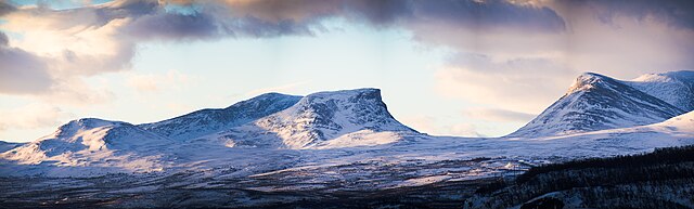
When two cirques on opposite sides of a ridge erode headward toward each other, the intervening rock is progressively narrowed into a knife-edge ridge called an arête. If three or more cirques converge on a single peak from different directions, the result is a steep pyramidal summit known as a horn. The Matterhorn on the Swiss-Italian border is the type example: its four sharply defined faces correspond to four cirques that eroded inward from the cardinal directions.1, 3 The concept of the "glacial buzzsaw" — the observation that maximum peak elevations in glaciated mountain ranges tend to cluster just above the equilibrium line altitude regardless of tectonic uplift rate — reflects the efficiency with which cirque erosion limits summit height.24
Below the cirque, a valley glacier carves a characteristic U-shaped valley (or glacial trough) with a broad, flat floor and steep sidewalls, contrasting sharply with the V-shaped profile of a river-cut valley. The cross-sectional shape results from the glacier's ability to erode laterally as well as vertically, planing the valley walls while deepening the floor. Hanging valleys form where tributary glaciers, being smaller and thinner than the main trunk glacier, erode their beds to a shallower depth; after deglaciation, the tributary valley is left perched above the main valley floor, often with a waterfall cascading from its lip. Yosemite Valley in California displays some of the most celebrated examples, with Bridalveil Fall dropping 189 metres from a hanging valley into the main trough.1, 3
At the scale of individual bedrock outcrops, the asymmetric forms called roches moutonnées record the contrasting erosional processes operating on opposite sides of a bedrock obstacle. The upstream (stoss) side is smoothed and striated by abrasion, while the downstream (lee) side is rough and angular, shaped by plucking where subglacial cavities form in the low-pressure zone behind the obstacle. The term, coined by Horace-Bénédict de Saussure in the eighteenth century, refers to the resemblance of these knobs to the wigs (moutons) worn in his era. Roches moutonnées are reliable indicators of former ice-flow direction because their stoss-lee asymmetry is consistently oriented with respect to the glacier's motion.9 Glacial striae — fine, parallel scratches on bedrock surfaces — provide even more precise constraints on local ice-flow vectors and are among the most commonly mapped features in glacial geomorphological surveys.1, 5
Fjords
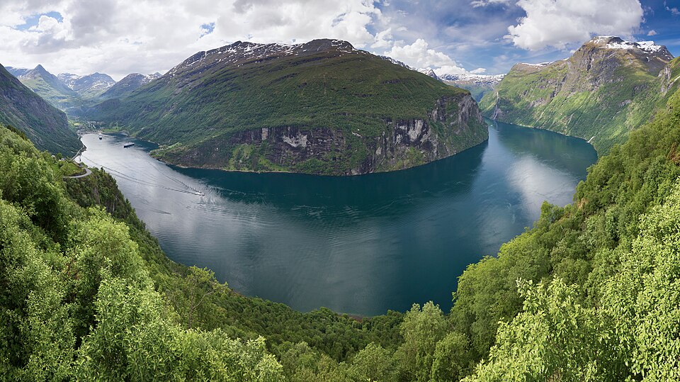
Fjords represent an extreme expression of glacial erosion: long, narrow, steep-walled inlets carved by outlet glaciers that drained coastal mountain ranges into the sea. The erosive power of an outlet glacier confined within a bedrock channel, combined with the fact that glaciers can erode well below sea level because ice thickness provides the driving stress, allows fjords to achieve extraordinary depths. Sognefjorden in western Norway, the deepest fjord in Europe, reaches a depth of 1,308 meters below sea level while extending 205 kilometers inland.14 Despite this immense depth along its length, Sognefjorden's mouth is guarded by a bedrock sill only about 100 meters deep — a characteristic threshold feature formed where the glacier thinned and spread as it reached the open ocean, reducing its erosive capacity.14, 25
Modeling work by Kessler and colleagues has shown that the longitudinal profiles of fjords — with their overdeepened basins and shallow sills — can be explained by a positive feedback between ice discharge and erosion. As a glacier flows through a narrowing in its bedrock channel, the ice thickens and accelerates, intensifying erosion and deepening the basin. At the marine margin, where the glacier terminates in a calving front, ice velocities diminish and deposition may exceed erosion, building the sill.25 Fjords are spectacularly developed along the coasts of Norway, Greenland, Chile, New Zealand's South Island, and British Columbia, all regions where steep coastal topography channeled Pleistocene ice directly into the ocean.1, 25
Depositional landforms
When a glacier melts or retreats, it releases its sediment load, constructing a suite of depositional landforms that record the position, geometry, and dynamics of the former ice margin. Moraines are ridges or sheets of glacial debris (till) deposited at the margins of a glacier. A terminal moraine (or end moraine) marks the position of maximum glacial advance, where material was bulldozed and dumped at the ice front during a period of equilibrium between accumulation and ablation. Recessional moraines are similar ridges formed during pauses in the glacier's retreat. Lateral moraines are elongate ridges deposited along the flanks of valley glaciers, built from debris that fell onto the glacier surface from the valley walls. Where two valley glaciers merge, their inner lateral moraines combine to form a medial moraine, a dark stripe of debris running down the centre of the enlarged glacier. Ground moraine is a blanket of till deposited beneath the glacier over a broad area, forming the gently undulating till plains that characterize much of the glaciated lowlands of North America and northern Europe.1, 2
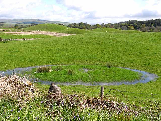
Drumlins are streamlined, elongated hills of glacial sediment shaped beneath a moving ice sheet. They typically occur in large fields or swarms, with their long axes aligned parallel to the direction of ice flow. A classic drumlin has a blunt, steep stoss end facing up-ice and a tapered, gentle lee end pointing down-ice, resembling the inverted hull of a boat. The origin of drumlins has been debated since the nineteenth century, with hypotheses ranging from subglacial sediment deformation to erosional streamlining of pre-existing deposits. Boulton's deformable-bed model proposes that drumlins form where till is moulded by differential pressure and shear stress at the base of the ice sheet,10 while more recent instability models suggest that drumlins arise spontaneously from perturbations in the coupling between ice flow, sediment transport, and subglacial water pressure.11 Major drumlin fields include those of central Ireland, the Eden Valley of northern England, and the extensive swarms across New York State and southern Ontario.1, 2
Eskers are sinuous ridges of stratified sand and gravel deposited by meltwater streams flowing within or beneath a glacier. They can extend for tens or even hundreds of kilometers and rise 10 to 30 meters above the surrounding terrain. Because the meltwater tunnels that formed them were pressurized conduits at the glacier bed, eskers can run uphill across the underlying topography — a feature that distinguishes them from ordinary fluvial deposits. The internal sedimentology of eskers, with their well-sorted, cross-bedded gravels and sands, contrasts markedly with the unsorted till of moraines and provides evidence for high-discharge subglacial drainage systems.12 Kames are irregular mounds of stratified sediment deposited in depressions on or against the ice surface; when the supporting ice melts, the sediment collapses into conical or flat-topped hills. Together, eskers, kames, and associated glaciofluvial deposits form the hummocky, pitted terrain characteristic of many formerly glaciated lowlands.1, 12
Outwash plains (also known by the Icelandic term sandur) are broad, gently sloping surfaces of stratified sand and gravel deposited by braided meltwater rivers issuing from the glacier terminus. They extend downstream from the moraine and grade laterally into finer-grained floodplain and lacustrine deposits. Kettle lakes form when blocks of ice buried within the outwash or moraine sediment eventually melt, leaving steep-sided depressions that fill with water. The lake-studded landscapes of Minnesota, Wisconsin, and Manitoba owe their character largely to kettle formation during the retreat of the Laurentide Ice Sheet.1, 2
Glacial erratics are boulders transported by ice far from their source bedrock and deposited in geologically incongruous settings when the glacier melted. Their identification and provenance tracing were among the earliest lines of evidence for continental glaciation, as Agassiz recognized in 1840. Because erratics can be matched to their source outcrops through lithological and geochemical analysis, they provide a direct measure of ice-flow paths over distances of hundreds of kilometers.1, 3
Till and glacial sedimentology
The sediments deposited by glaciers fall into two broad categories that record fundamentally different transport and depositional processes. Till (or glacial diamicton) is material deposited directly from the ice without reworking by water. It is characteristically unsorted, containing a chaotic mixture of clay, silt, sand, pebbles, cobbles, and boulders in a muddy matrix. Clasts within till are often faceted and striated from abrasion at the glacier bed. Till can be subdivided into lodgement till, plastered onto the bed beneath the moving glacier by frictional drag, and ablation till, released from the ice surface during melting and let down onto the ground. These two types differ in their degree of compaction, clast fabric, and geotechnical properties, and their distinction is important for engineering geology and groundwater hydrology in glaciated regions.1, 22
In contrast, glaciofluvial deposits are sediments sorted and stratified by meltwater and are indistinguishable in many respects from ordinary fluvial sediments except for their association with glacial landforms and their often abrupt lateral facies changes. Glaciofluvial gravels form eskers, kames, and outwash; glaciolacustrine deposits accumulate in proglacial and ice-dammed lakes and are characterized by fine laminations, including the annual couplets of coarse (summer) and fine (winter) layers known as varves. Varve counting provides a precise chronological tool analogous to tree-ring dating and has been used to establish floating chronologies spanning thousands of years in formerly glaciated regions of Scandinavia and North America.1, 2
Glacial lakes
Glaciers and ice sheets create lakes through several mechanisms, and many of the world's largest freshwater bodies owe their existence to glacial processes. Proglacial lakes form in front of a retreating glacier, impounded behind moraines or in basins scoured by the ice. Subglacial lakes exist beneath the ice sheet itself, maintained in a liquid state by geothermal heat and the insulating effect of the overlying ice; more than 400 subglacial lakes have been identified beneath the Antarctic ice sheet, the largest being Lake Vostok, which covers approximately 14,000 square kilometers beneath nearly 4 kilometers of ice.4 Ice-dammed lakes form when a glacier blocks a river valley, impounding water behind it until the dam fails catastrophically — a process that produces some of the most violent floods in the geological record.17
The most celebrated example of ice-dam failure is Glacial Lake Missoula, a vast body of water that formed repeatedly during the late Pleistocene when the Cordilleran Ice Sheet's Purcell Lobe dammed the Clark Fork River in western Montana. At its maximum, the lake held approximately 2,500 cubic kilometers of water — roughly half the volume of modern Lake Michigan. When the ice dam floated and ruptured, the lake drained in a catastrophic flood that raced across eastern Washington at estimated velocities exceeding 30 meters per second, stripping soil and loess from the landscape and carving the extraordinary complex of dry channels, cataracts, and gravel bars known as the Channeled Scablands.16, 17 J Harlen Bretz first described these features in 1923, proposing a catastrophic flood origin that was initially rejected by the geological establishment but was vindicated by decades of subsequent field work, including Pardee's 1942 identification of giant current ripples on the floor of the former lake.16, 17
Continental ice sheet landscapes
The great Pleistocene ice sheets that covered North America and northern Eurasia left an indelible imprint on the continental landscape. The Great Lakes of North America — Superior, Michigan, Huron, Erie, and Ontario — occupy basins that were deepened and widened by repeated glacial advances along pre-existing structural weaknesses and river valleys in the bedrock. Lake Superior, the largest freshwater lake by surface area in the world, fills a basin eroded partly along the Midcontinent Rift, where 1.1-billion-year-old volcanic rocks created a zone of relative weakness that the ice exploited. The current drainage of the Great Lakes system, flowing eastward through the St. Lawrence River, was established only after deglaciation reshaped the continental drainage, as earlier glacial stages had directed meltwater southward through the Mississippi system.15
The Scandinavian shield landscape of Finland, Sweden, and Norway bears equally clear evidence of continental glaciation. The Fennoscandian Ice Sheet, centred over the Gulf of Bothnia, repeatedly advanced and retreated across the shield, scouring the bedrock surface into a terrain of low, rounded hills, innumerable lake basins, and vast fields of drumlins and eskers. Finland alone contains approximately 188,000 lakes, the majority of which occupy ice-scoured basins or depressions left by differential erosion between resistant and weak rock types. The esker systems of Finland and Sweden extend for hundreds of kilometers and are so prominent that they have been used as transportation routes since prehistoric times.1, 23
Alpine glacial landscapes
Alpine glaciation has sculpted some of the most dramatic mountain scenery on Earth. The Swiss Alps are the type locality for many glacial landform terms — cirque, moraine, and erratic all entered English from French-speaking Alpine geologists — and preserve a textbook succession of horns, arêtes, U-shaped valleys, and hanging valleys. The Rhone glacier, which once filled the entire valley now occupied by Lake Geneva, deposited the massive terminal moraines that form the amphitheatre around the lake's western end. Louis Agassiz conducted his pioneering glaciological observations in the Unteraar Glacier region in the 1840s, making the Alps the birthplace of glacial geology as a scientific discipline.1, 3
In the Himalaya and Karakoram, glacial geomorphology records the interplay between rapid tectonic uplift and intense glacial erosion. Owen and colleagues have mapped multiple generations of moraines in the Karakoram valleys, dating them with cosmogenic nuclide exposure methods and demonstrating that glacial advances in the region were asynchronous with those in the Northern Hemisphere mid-latitudes, instead reflecting the influence of the South Asian monsoon on regional precipitation patterns.19 The concept of the glacial buzzsaw — that glacial erosion limits mountain height to a ceiling determined by the equilibrium line altitude rather than by tectonic uplift rate — was developed in part from observations of the remarkably uniform summit heights across the Himalayan range despite large variations in rock uplift rate.24
Patagonia, at the southern tip of South America, preserves one of the most complete records of Quaternary glaciation in the Southern Hemisphere. The Patagonian Ice Sheet, which at its maximum extended from approximately 38°S to 56°S, deposited extensive moraine sequences on the eastern steppe that have been dated using cosmogenic exposure methods, radiocarbon, and tephrochronology. Glasser and colleagues demonstrated that glacial advances in Patagonia were broadly synchronous with those in the Northern Hemisphere during the Last Glacial Maximum, supporting the hypothesis that globally synchronous forcing — particularly atmospheric CO2 changes — played a dominant role in driving Southern Hemisphere glaciation, even though insolation forcing is antiphased between the hemispheres.18
Major glacial landforms
Major glacial landform types1, 3
| Landform | Type | Formation process | Typical scale | Classic example |
|---|---|---|---|---|
| Cirque | Erosional | Plucking and freeze-thaw at glacier head | 0.5–3 km diameter | Cwm Idwal, Wales |
| Arête | Erosional | Headward erosion of opposing cirques | 1–20 km length | Striding Edge, Lake District |
| Horn | Erosional | Convergence of three or more cirques | Single peak | Matterhorn, Swiss Alps |
| U-shaped valley | Erosional | Lateral and vertical erosion by valley glacier | 1–100 km length | Yosemite Valley, California |
| Fjord | Erosional | Deep erosion by marine-terminating outlet glacier | 10–300 km length, up to 1,300 m depth | Sognefjorden, Norway |
| Roche moutonnée | Erosional | Abrasion (stoss) and plucking (lee) | 1–100 m length | Central Park, New York City |
| Terminal moraine | Depositional | Sediment accumulation at glacier terminus | 1–50 km length, 10–100 m height | Long Island, New York |
| Drumlin | Depositional | Subglacial moulding of till | 0.1–2 km length, 5–50 m height | Clew Bay, Ireland |
| Esker | Depositional | Deposition by subglacial meltwater streams | 1–500 km length, 10–30 m height | Punkaharju, Finland |
| Glacial erratic | Depositional | Ice transport and release during melting | 0.1–20 m diameter (single boulder) | Big Rock, Okotoks, Alberta |
| Kettle lake | Depositional | Melting of buried ice blocks in outwash | 0.01–5 km diameter | Walden Pond, Massachusetts |
| Outwash plain | Depositional | Braided meltwater deposition beyond ice margin | 10–100+ km extent | Skeidarársandur, Iceland |
Modern mapping and paleoglacial reconstruction
The advent of remote sensing technologies has transformed glacial geomorphology from a discipline reliant on laborious field mapping to one capable of surveying entire formerly glaciated regions at high resolution. Airborne LiDAR (Light Detection and Ranging) has proven especially valuable because its laser pulses penetrate forest canopy, revealing the bare-earth topography beneath. In densely forested regions of Scandinavia and Canada, LiDAR surveys have uncovered drumlin fields, esker networks, and moraines that were invisible on aerial photographs and satellite imagery. Chandler and colleagues reviewed the impact of LiDAR on glacial mapping and concluded that the technology has increased the number of identified glacial landforms by an order of magnitude in many study areas, fundamentally altering reconstructions of former ice-sheet geometry and dynamics.20
Satellite-based synthetic aperture radar (SAR) and high-resolution optical imagery complement LiDAR by providing coverage of remote and inaccessible terrain, including the Antarctic continental shelf, where submarine glacial landforms — mega-scale glacial lineations, grounding-zone wedges, and iceberg ploughmarks — record the former extent and retreat dynamics of the Antarctic Ice Sheet during the last deglaciation.13 Greenwood and Clark used LiDAR-derived digital elevation models to remap the glacial geomorphology of large areas of Scandinavia, identifying previously unrecognized flow sets and ice-stream tracks that required significant revision of existing ice-sheet reconstructions.23
These improved geomorphological datasets feed directly into paleoglacial reconstruction, the effort to determine the dimensions, dynamics, and chronology of former ice sheets. Clark and colleagues have developed systematic frameworks that integrate geomorphological mapping with geochronological data (radiocarbon dates, cosmogenic nuclide exposure ages, and optically stimulated luminescence ages) to produce time-slice reconstructions of the British-Irish Ice Sheet and the Laurentide Ice Sheet at millennial resolution.21 Such reconstructions are essential for constraining numerical ice-sheet models, which in turn provide the physical understanding needed to predict the future behavior of the Greenland and Antarctic ice sheets under anthropogenic climate warming.4, 21
References
Rates of erosion and sediment evacuation by glaciers: a review of field data and their implications
The instability theory of drumlin formation and its explanation of their varied composition and internal structure
Sognefjorden in western Norway – physiography, geomorphology, marine levels and deglaciation history