Overview
- The Hawaiian-Emperor seamount chain is a 6,000-kilometre trail of volcanic islands and drowned seamounts stretching across the North Pacific, produced as the Pacific Plate drifts northwestward over a stationary mantle hotspot — the age of each volcano increases systematically with distance from the active Big Island, providing one of geology’s most direct demonstrations of deep time and plate motion.
- K-Ar and 40Ar/39Ar dating documents a continuous age progression from the still-forming Loihi Seamount and the Big Island (0 Ma) through Kauai (~5.1 Ma) and on to the Meiji Seamount (~82–85 Ma) near the Aleutian Trench, with a conspicuous ~47-degree bend at ~47 Ma recording a change in Pacific Plate motion direction.
- Modern GPS measurements confirm the Pacific Plate is currently moving ~7 cm per year to the northwest, independently corroborating the radiometric age progression and making the entire chain a real-time, testable record of 85 million years of geological activity that cannot be reconciled with a young-Earth timescale.
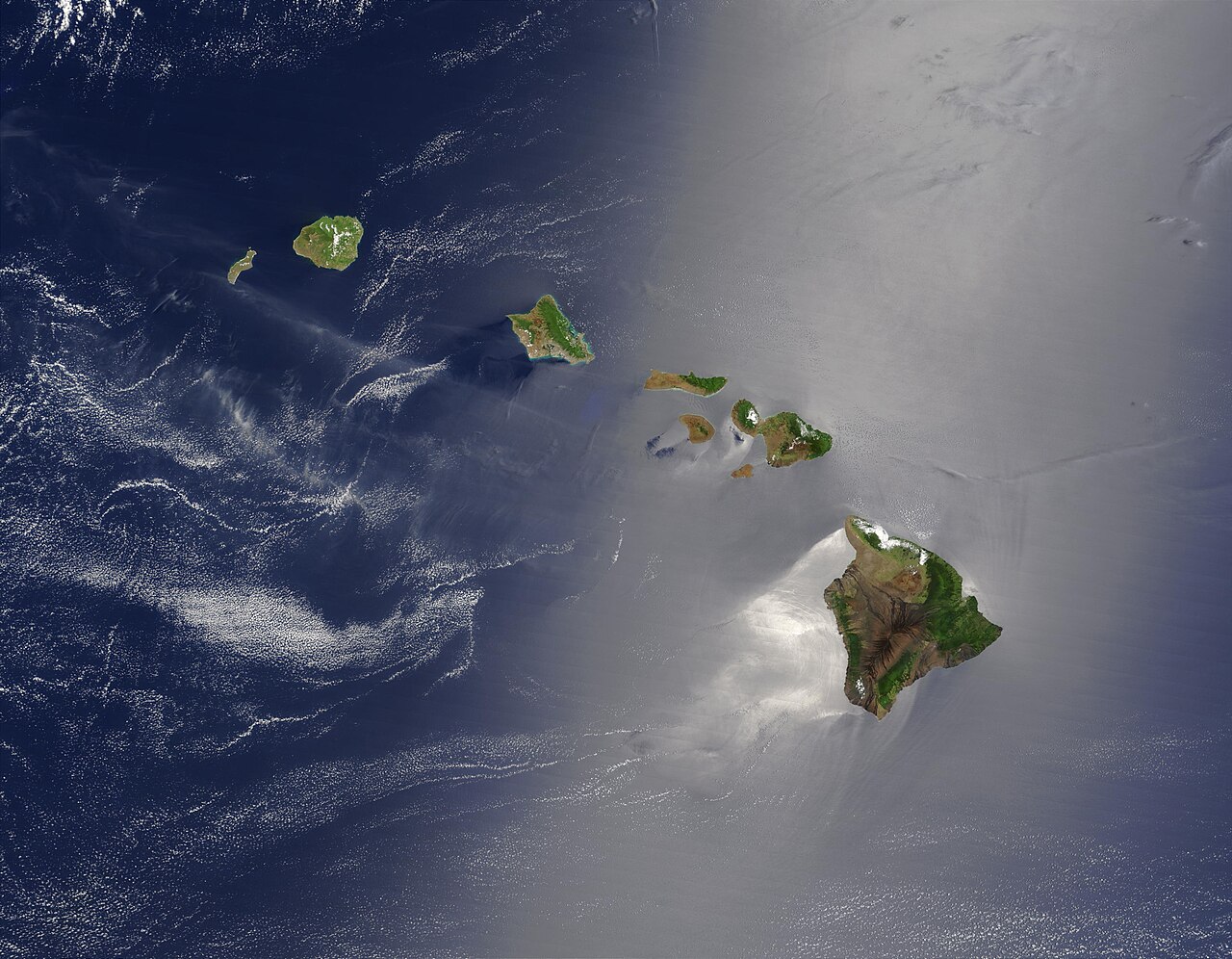
Few geological features illustrate the workings of deep time as directly as the Hawaiian island chain. Stretching more than 6,000 kilometres across the North Pacific Ocean, the Hawaiian-Emperor seamount chain is a continuous trail of volcanic edifices whose ages increase systematically from zero at the active Big Island of Hawaii to more than 82 million years at the Meiji Seamount near the Aleutian Trench.2, 17 Each volcano marks a position where the Pacific Plate once sat above a relatively stationary source of heat deep in the mantle; as the plate drifted northwestward, it carried each spent volcano away and allowed the next to form.1 The chain is simultaneously a record of plate motion, a radiometric clock stretched across the ocean floor, and a demonstration that geological processes have been operating continuously for tens of millions of years — a timescale accessible to direct measurement, not inference.
Wilson’s hotspot hypothesis
The modern interpretation of the Hawaiian Islands began with a paper by the Canadian geophysicist J. Tuzo Wilson published in 1963.1 Wilson noted that the Hawaiian Islands display a clear age gradient: the northwestern islands are more eroded and geologically older, while the southeastern islands and the Big Island itself host active volcanism. He proposed that this pattern could be explained if the Pacific Ocean floor were drifting over a fixed point of intense volcanic activity in the underlying mantle — what he called a “hot spot.” On this model, volcanoes do not erupt at random; they form above the hotspot, build to their maximum size during a shield-building stage, then are carried away from the heat source by plate motion. Cut off from their magma supply, they subside, erode, and eventually sink below sea level to become flat-topped seamounts called guyots.
Wilson’s 1963 hypothesis predated the widespread acceptance of plate tectonics by several years and was therefore framed in terms of a drifting ocean floor rather than moving lithospheric plates, but the underlying geometry was correct. In 1971, W. Jason Morgan formalised the plume concept, proposing that hotspots are the surface expressions of narrow columns of anomalously hot rock — mantle plumes — rising from near the core-mantle boundary at a depth of roughly 2,900 kilometres.4 The Hawaiian hotspot became, and remains, the canonical example against which all other proposed hotspots are compared. The empirical test of the hypothesis is straightforward: if the model is correct, radiometric dating of the volcanic rocks along the chain should reveal a smooth age progression, with older ages at greater distances from the active volcanoes. That is precisely what decades of K-Ar and 40Ar/39Ar geochronology have confirmed.
The age progression: K-Ar dating of the chain
Systematic radiometric dating of the Hawaiian-Emperor chain was largely accomplished through the work of David Clague, Brent Dalrymple, and their collaborators beginning in the 1970s and continuing through the Ocean Drilling Program in subsequent decades.2 The method applied is potassium-argon (K-Ar) dating and its more precise variant, the 40Ar/39Ar technique, both of which rely on the radioactive decay of potassium-40 to argon-40 with a half-life of approximately 1.25 billion years. Because basaltic lavas lose all their radiogenic argon when erupted, the accumulated argon in a cooled lava sample directly records the time elapsed since eruption — the age of the volcano itself.
The results are unambiguous. The Big Island of Hawaii, which hosts the currently active Kilauea and Mauna Loa volcanoes, is geologically newborn; its oldest subaerial lavas are less than 700,000 years old and the edifice is still growing.14 Moving northwest along the chain, ages increase at a roughly constant rate. Maui is approximately 1.0–1.3 million years old. Molokai and Lanai range from about 1.3 to 1.8 Ma. Oahu’s main shield volcanoes, Waianae and Koolau, date to roughly 2.5–3.7 Ma. Kauai, the oldest of the main Hawaiian Islands visible above sea level, yields K-Ar ages of approximately 5.1 million years.2 Beyond Kauai, the chain continues northwest as a series of low, wave-eroded atolls and reef shoals — Nihoa, Necker, Gardner Pinnacles, Laysan, Midway — before the islands disappear entirely beneath sea level to become seamounts. Midway Atoll, famous from the 1942 naval battle, has basaltic basement dated to approximately 27.7 Ma. The chain then extends as the Emperor Seamounts, trending roughly northward, with ages increasing to approximately 47 Ma at the Detroit and Daikakuji seamounts near the chain’s prominent bend, and reaching 82–85 Ma at the Meiji Seamount near the Aleutian Trench.17
The age-versus-distance relationship yields a plate velocity of approximately 7 to 9 centimetres per year — a figure that agrees closely with independent geodetic measurements of present-day Pacific Plate motion.9, 10 This consistency across two entirely independent lines of evidence — the decay of radioactive isotopes in ancient rocks, and the satellite-measured movement of the plate today — constitutes a powerful mutual confirmation that both the radiometric ages and the GPS velocities are measuring the same underlying reality.
Selected radiometric ages along the Hawaiian-Emperor chain2, 3, 17
| Volcanic feature | Age (Ma) | Notes |
|---|---|---|
| Loihi Seamount | 0 (active) | Still underwater; next Hawaiian island |
| Kilauea / Big Island | 0–0.7 | Currently active shield stage |
| Kauai | ~5.1 | Oldest main Hawaiian island above sea level |
| Midway Atoll | ~27.7 | Coral atoll on drowned shield |
| Chain bend (Detroit/Daikakuji) | ~47 | Marks change in Pacific Plate motion |
| Suiko Seamount | ~61 | Upper Emperor Seamounts |
| Meiji Seamount | ~82–85 | Oldest dated feature; near Aleutian Trench |
The Emperor bend and changing plate motion
At roughly 47 million years ago, the Hawaiian-Emperor chain exhibits a conspicuous change in orientation. North of the bend, the Emperor Seamounts trend approximately northward; south of it, the Hawaiian chain trends northwest. The angle between the two segments is approximately 47 degrees.3 This geometric inflection, clearly visible on any bathymetric map of the North Pacific, was recognised early as a potential record of a change in Pacific Plate motion direction.
The precise age of the bend was established by Sharp and Clague in a 2006 study using high-precision 40Ar/39Ar dating of basalt samples from seamounts immediately on either side of the elbow, which yielded ages converging on approximately 47 Ma.3 The traditional interpretation attributed the bend entirely to a sudden shift in the direction of Pacific Plate movement, possibly caused by the initiation of subduction in the western Pacific or by the collision of the Indian subcontinent with Asia and the associated reorganisation of mantle flow. However, subsequent palaeomagnetic work by Tarduno and colleagues complicated this picture by showing that the Emperor Seamounts formed at significantly lower latitudes than the present position of the Hawaiian hotspot, implying that the hotspot itself drifted southward during the Emperor stage at a rate of several centimetres per year.6, 11 On this revised interpretation, the bend reflects a combination of two processes: genuine southward drift of the plume during the Cretaceous and early Palaeogene, followed by the plume’s stabilisation and a concurrent change in Pacific Plate motion direction around 47 Ma. Disentangling these contributions remains an active research problem, but the broad picture — that the bend records tens of millions of years of changing plate and plume dynamics — is firmly established.
Shield building, erosion, and subsidence
Each Hawaiian volcano passes through a well-defined sequence of stages as it moves away from the hotspot, and this life cycle is itself a demonstration of geological processes operating over timescales far exceeding any human framework.14 The pre-shield stage involves intermittent, alkalic eruptions on the deep ocean floor as the plate approaches the hotspot. The shield stage is the main growth phase, during which the volcano erupts enormous volumes of tholeiitic basalt at high rates, building the broad, gently sloping shield form that gives Hawaiian volcanoes their distinctive profile. Mauna Loa and Kilauea are currently in shield stage. The shield stage accounts for more than 95 percent of the total volume of a Hawaiian volcano and can construct a edifice rising more than 9 kilometres from the ocean floor to its summit — making Mauna Kea, measured from its base, the tallest mountain on Earth.15
Once the plate carries the volcano sufficiently far from the hotspot, the magma supply diminishes and the eruption rate drops sharply. The volcano enters the post-shield stage, during which smaller volumes of more silica-rich, alkalic lavas cap the shield. Eruptions become increasingly infrequent. Simultaneously, the lithosphere flexes downward under the weight of the volcanic edifice and cools as it moves away from the hotspot’s thermal swell, causing the island to subside at rates of several millimetres per year. Erosion by waves, rain, and streams cuts deeply into the flanks. Kauai, at 5.1 Ma, already shows this advanced erosion: its dramatic sea cliffs and deeply incised valleys, including the Na Pali Coast, record millions of years of surface weathering acting on a no-longer-replenished volcanic pile.7
Eventually the island subsides below sea level entirely, leaving a flat-topped seamount called a guyot, its summit planed off by wave erosion during its final years above water. A thin cap of coral limestone may accumulate on the subsiding platform, producing an atoll — Midway and the other Northwestern Hawaiian Islands represent precisely this transitional stage. Still further down the chain, the coral can no longer keep pace with subsidence, the reef drowns, and nothing remains above sea level.14, 15 The entire sequence from active shield to drowned seamount plays out over tens of millions of years, and the chain presents all stages simultaneously, from the newborn Loihi Seamount underwater to the 85-million-year-old Meiji Seamount approaching the Aleutian Trench where it will eventually be consumed by subduction.
Loihi: the next island forming now
Approximately 35 kilometres south-southeast of the Big Island’s southern coast, at a depth of about 975 metres below the ocean surface, a new Hawaiian volcano is actively building itself. Loihi Seamount is still entirely submerged, but it is erupting basaltic lava, accumulating mass, and rising toward sea level on a geological timescale.8 Geologists estimate that Loihi will emerge above sea level in roughly 10,000 to 100,000 years, at which point it will constitute the newest Hawaiian island and will have displaced the Big Island as the chain’s active centre. The seamount hosts an active hydrothermal vent system, and its rocky flanks support chemosynthetic microbial communities that draw energy from volcanic gases rather than sunlight — a small-scale parallel to the deep-sea vent ecosystems found along mid-ocean ridges.
The existence of Loihi provides a present-tense anchor for the chain’s age progression. The same radiometric and GPS evidence that documents the Pacific Plate carrying Kauai away from the hotspot at ~7 cm per year also predicts that a new volcano should currently be forming southeast of the Big Island — and there it is, exactly where the model requires it to be.1, 8 The hotspot hypothesis generates testable predictions, and observation confirms them.
GPS confirmation and the rate of plate motion
One of the most direct confirmations of the Hawaiian chain’s geological interpretation comes from space geodesy. The Global Positioning System, and before it very-long-baseline interferometry (VLBI), allow the positions of points on the Earth’s surface to be measured with millimetre-scale precision across baselines of thousands of kilometres. Repeated measurements over years and decades directly resolve the motion of the Pacific Plate.9, 10
These measurements consistently show the Pacific Plate moving approximately 7 centimetres per year to the northwest relative to a fixed reference frame anchored to the deep mantle.9, 10 This figure is not inferred from ancient rocks; it is measured directly by satellites tracking the positions of GPS receivers bolted to Hawaiian bedrock year after year. The geodetic velocity agrees, within uncertainty, with the velocity implied by dividing the ages of the chain’s volcanoes by their distances from Kilauea.2 Two entirely independent methods of measurement — one based on the nuclear physics of radioactive decay in ancient basalts, the other based on microwave ranging between satellites and ground receivers — converge on the same answer.
This convergence has a direct implication for the chain’s age span. If the Pacific Plate is moving at ~7 cm per year, and the Meiji Seamount sits approximately 6,000 kilometres from Kilauea, simple arithmetic yields an age of ~86 million years for the Meiji — consistent with its measured radiometric age of 82–85 Ma.17 The agreement is not coincidental; it is the expected result if the Earth is genuinely old and if the physical constants governing both radioactive decay and orbital mechanics have remained stable.
Deep time and the young-Earth problem
The Hawaiian-Emperor chain presents a particular challenge to young-Earth creationism (YEC) because the evidence for its antiquity is multi-layered, physically independent, and internally self-consistent.2, 9 A young-Earth interpretation would require, at minimum, all of the following to be simultaneously true: that K-Ar and 40Ar/39Ar radiometric ages are systematically wrong by factors of millions; that GPS-measured plate velocities cannot be extrapolated even a few thousand years into the past; that the physical erosion, subsidence, coral reef growth, and drowning of islands visible at every stage along the chain somehow occurred within the last few thousand years; and that the 6,000-kilometre geometric trail of progressively older volcanoes was produced by some mechanism other than the one it so clearly exemplifies.
No mechanism capable of producing the observed age progression in a short timescale has been proposed that does not simultaneously violate well-tested physics. Rapid plate motion would require enormous heat dissipation inconsistent with the present thermal state of the lithosphere. Accelerated radioactive decay would produce lethal radiation doses and melt the crust. The subsidence and erosion sequence preserved along the chain records physical processes whose rates are measurable today and have been measured independently in multiple geological contexts.5, 7 The chain is not merely old by one line of evidence; it is old by every applicable physical test, and those tests agree with each other to within their stated uncertainties.
Seismic tomography adds a further dimension to this picture. High-resolution whole-mantle tomographic imaging has resolved a broad, low-seismic-velocity anomaly beneath the Hawaiian hotspot extending deep into the lower mantle — the thermal signature of the plume itself.12, 13, 16 The plume’s existence as a physical structure in the mantle today, confirmed by independent geophysical imaging, provides a mechanistic account of why the age progression exists and why it has the form it does. The chain is not an unexplained pattern requiring special pleading; it is the expected surface expression of a well-understood physical process operating over the timescale that radiometric dating independently documents.
The Hawaiian island chain is, in this sense, geology’s clearest open-air exhibit of deep time. Unlike the abstract ages attached to ancient rock formations or meteorites, the chain presents its evidence visually and sequentially: one can trace a line from a still-submerged newborn volcano to a 5-million-year-old eroded island to a 27-million-year-old atoll to an 85-million-year-old seamount approaching the trench that will eventually consume it.2, 17 Each stage is a frozen moment in a continuous process that has been running, uninterrupted, for longer than any human civilisation has existed by a factor of ten thousand.
References
- Wilson, J. T. “A hot spot in the Pacific: origin and distribution of the Hawaiian Islands.” Canadian Journal of Physics 41: 863–870, 1963. doi:10.1139/p63-094
- Clague, D. A. & Dalrymple, G. B. “Ages of the Hawaiian-Emperor chain and volcanism on the Hawaiian Islands.” In The Eastern Pacific Ocean and Hawaii (Geology of North America, vol. N), Geological Society of America, 187–217, 1989. doi:10.1130/DNAG-GNA-N.187
- Sharp, W. D. & Clague, D. A. “Bend in the Hawaiian-Emperor chain and age of Hawaiian volcanism.” Science 313: 1281–1284, 2006. doi:10.1126/science.1128489
- Morgan, W. J. “Convection plumes in the lower mantle.” Nature 230: 42–43, 1971. doi:10.1038/230042a0
- Dalrymple, G. B., Silver, E. A. & Jackson, E. D. “K-Ar ages and the opening of the Atlantic Ocean.” Science 171: 1137–1141, 1971. doi:10.1126/science.171.3976.1137
- Tarduno, J. A. et al. “Paleolatitudes of the Hawaiian-Emperor seamount chain: implications for the Hawaiian hotspot fixity.” Science 301: 1064–1069, 2003. doi:10.1126/science.1086442
- Clague, D. A. & Sherrod, D. R. “Postshield and posterosional volcanism of the Hawaiian Islands.” In Characteristics of Hawaiian Volcanoes, U.S. Geological Survey Professional Paper 1801, 2014. doi:10.3133/pp1801
- Karl, D. M. et al. “Loihi Seamount, Hawaii: a mid-plate volcano with a distinctive hydrothermal system.” Nature 335: 532–535, 1988. doi:10.1038/335532a0
- DeMets, C., Gordon, R. G. & Argus, D. F. “Geologically current plate motions.” Geophysical Journal International 181: 1–80, 2010. doi:10.1111/j.1365-246X.2009.04491.x
- Larson, K. M. et al. “Present plate motion and crustal deformation from the Global Positioning System.” Journal of Geophysical Research 102: 9961–9981, 1997. doi:10.1029/96JB03491
- Tarduno, J. A. & Cottrell, R. D. “The Emperor seamounts: southward motion of the Hawaiian hotspot plume in Earth’s mantle.” Science 278: 1499–1504, 1997. doi:10.1126/science.278.5344.1499
- Montelli, R. et al. “Finite-frequency tomography reveals a variety of plumes in the mantle.” Science 303: 338–343, 2004. doi:10.1126/science.1092485
- French, S. W. & Romanowicz, B. “Broad plumes rooted at the base of the Earth’s mantle beneath major hotspots.” Nature 525: 95–99, 2015. doi:10.1038/nature14876
- Clague, D. A. & Dalrymple, G. B. “The stages of Hawaiian volcanism.” In Volcanism in Hawaii, U.S. Geological Survey Professional Paper 1350, 1–54, 1987. doi:10.3133/pp1350
- Moore, J. G. et al. “Growth, collapse, and turbidite sedimentation of the Hawaii-Emperor seamount chain.” Geology 17: 1107–1111, 1989. doi:10.1130/0091-7613(1989)017<1107:GCATSO>2.3.CO;2
- Wolfe, C. J. et al. “Hawaiian volcanism: deep structure and origin.” Science 326: 1388–1390, 2009. doi:10.1126/science.1180165
- Regelous, M. et al. “Age of the Meiji Seamount and implications for Pacific Plate motion.” Earth and Planetary Science Letters 277: 420–427, 2009. doi:10.1016/j.epsl.2008.11.015
References
Paleolatitudes of the Hawaiian-Emperor seamount chain: implications for the Hawaiian hotspot fixity
The Emperor seamounts: southward motion of the Hawaiian hotspot plume in Earth’s mantle