Overview
- The Ancestral Pueblo peoples (formerly 'Anasazi') developed one of North America's most architecturally sophisticated pre-Columbian traditions across the arid Colorado Plateau, progressing from semi-subterranean pit houses to multi-storey masonry Great Houses at Chaco Canyon and cliff dwellings at Mesa Verde over a span of nearly two millennia.
- Chaco Canyon served as the political and ceremonial hub of the Ancestral Pueblo world from approximately 850 to 1150 CE, with a network of over 200 kilometres of engineered roads, massive Great Houses containing hundreds of rooms, and long-distance exchange connections extending to Mesoamerica.
- A prolonged drought in the late thirteenth century, combined with resource depletion, social conflict, and shifting political networks, triggered a large-scale migration out of the Four Corners region by 1300 CE, with descendant communities establishing themselves in the Rio Grande valley and other areas where their modern Pueblo successors live today.
The Ancestral Pueblo peoples—formerly known by the Navajo term "Anasazi," now generally avoided by archaeologists out of respect for Pueblo preferences—were the pre-Columbian inhabitants of the Four Corners region of the American Southwest, where the modern states of Colorado, Utah, Arizona, and New Mexico converge. Over a span of nearly two millennia, from roughly the first centuries CE through the late thirteenth century, these communities developed one of North America's most architecturally and socially complex pre-contact traditions, progressing from semi-subterranean pit houses to elaborate multi-storey masonry structures, including the Great Houses of Chaco Canyon and the cliff dwellings of Mesa Verde.4, 15 Their descendants are the modern Pueblo peoples of New Mexico and Arizona—including the Hopi, Zuni, Acoma, and the Tewa, Tiwa, and Keres-speaking communities of the Rio Grande valley—who maintain cultural, linguistic, and spiritual continuities with their ancestral past.15
From pit houses to pueblos
The earliest Ancestral Pueblo communities, dating to the Basketmaker II period (c. 100 BCE–500 CE), were semi-sedentary cultivators who grew maize and squash on the Colorado Plateau while continuing to rely heavily on wild plant foods and hunting. They lived in shallow pit houses—semi-subterranean structures with timber-and-earth roofs—and produced distinctive coiled basketry that gives the period its name.15, 4 The transition to the Basketmaker III period (c. 500–750 CE) brought deeper, more formalised pit houses, the introduction of pottery, the adoption of the bow and arrow, and the addition of beans to the agricultural repertoire, completing the maize-beans-squash triad that would sustain Pueblo communities for centuries.15
The shift from subterranean to above-ground masonry architecture began during the Pueblo I period (c. 750–900 CE), when communities constructed arcs or rows of contiguous stone-and-mud rooms behind their pit structures, which gradually evolved into the subterranean ceremonial chambers known as kivas. By the Pueblo II period (c. 900–1150 CE), villages of multi-room masonry "pueblos" had become the standard settlement form, and the pit house had been fully transformed into the kiva—a circular, semi-subterranean room used for religious ceremonies, community meetings, and craft production, featuring a ventilator shaft, a deflector stone, a central hearth, and a sipapu, a small hole in the floor symbolising the place of emergence from the underworld in Pueblo cosmology.15, 7
Chaco Canyon
The apogee of Ancestral Pueblo political and architectural complexity was reached at Chaco Canyon, a shallow desert canyon in northwestern New Mexico that served as the ceremonial and possibly political centre of a regional system spanning much of the San Juan Basin from approximately 850 to 1150 CE. The canyon contains more than a dozen "Great Houses"—massive multi-storey masonry structures of unprecedented scale and sophistication.3, 5 The largest, Pueblo Bonito, contained at least 650 rooms and 35 kivas arranged in a D-shaped plan rising four storeys at its tallest point. Tree-ring dating indicates that Pueblo Bonito was built in several major construction episodes between approximately 860 and 1120 CE, using hundreds of thousands of shaped sandstone blocks and an estimated 215,000 timber beams, many of which were transported from forests 60 to 80 kilometres distant.5, 3
Chaco's Great Houses were connected by a remarkable system of engineered roads, totalling over 200 kilometres of documented segments, that extended in straight lines across the landscape to outlying communities and distant resource zones. The roads, typically nine metres wide and often cut into bedrock or bordered by low masonry walls, have been interpreted variously as pilgrimage routes, processional ways, cosmological alignments, and practical transportation corridors.2, 13 The discovery of cacao residue in cylindrical jars from Pueblo Bonito by Patricia Crown and Jeffrey Hurst demonstrated that Chacoan elites had access to Mesoamerican trade goods, since cacao (Theobroma cacao) does not grow in the American Southwest and must have been obtained through long-distance exchange networks extending more than 2,000 kilometres to the south.10
The nature of Chaco's political authority remains one of the most debated questions in Southwestern archaeology. Some scholars interpret the canyon as a ritual pilgrimage centre without permanent residential population of significant size, while others argue for a more directly political role, with Chacoan elites exercising hierarchical control over outlying communities through tribute, labour mobilisation, and ideological authority.2, 5, 13 Demographic modelling by Kohler and Reese has identified a boom-and-bust population cycle in the Chaco region, with rapid growth during the tenth and eleventh centuries followed by steep decline, suggesting that the system was inherently unstable and vulnerable to environmental or social disruption.11
Mesa Verde and the cliff dwellings
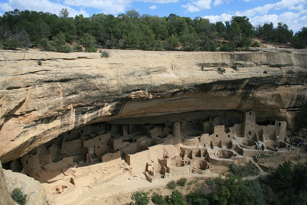
After Chaco Canyon's decline in the mid-twelfth century, the demographic and architectural centre of gravity shifted northward to the Mesa Verde region of southwestern Colorado, where Ancestral Pueblo communities constructed the cliff dwellings that have become the most iconic images of the pre-Columbian Southwest. During the Pueblo III period (c. 1150–1300 CE), populations aggregated into increasingly large villages, many of them built into the natural sandstone alcoves that punctuate the canyon walls of Mesa Verde, Hovenweep, and surrounding areas.7, 6
The largest cliff dwelling, Cliff Palace at Mesa Verde, contains approximately 150 rooms and 23 kivas sheltered within a massive alcove measuring roughly 89 metres long and 18 metres deep. First systematically studied by Gustav Nordenskiöld in 1891, Cliff Palace housed an estimated 100 to 120 people at its peak and served both residential and ceremonial functions.6, 7 The choice to relocate into defensible cliff alcoves during this period is widely interpreted as a response to increasing inter-community violence, a conclusion supported by bioarchaeological evidence of traumatic injuries, skeletal disarticulation, and unburied remains at several sites in the northern San Juan region during the twelfth and thirteenth centuries.9
The thirteenth-century abandonment
By approximately 1300 CE, the entire Four Corners region had been depopulated, a large-scale abandonment that constitutes one of the most dramatic demographic events in pre-Columbian North American history. Tree-ring records document a devastating drought lasting from 1276 to 1299—the "Great Drought"—that severely reduced the growing season and made rain-fed maize agriculture increasingly unreliable across the Colorado Plateau.12 However, earlier droughts of comparable severity had not triggered abandonment, leading archaeologists to conclude that the thirteenth-century departure resulted from a convergence of factors rather than climate alone.9, 14
Resource depletion from centuries of farming, deforestation for construction timber and firewood, soil erosion, and the breakdown of regional exchange networks all contributed to the diminishing viability of Four Corners settlements. Archaeological evidence of escalating warfare and social conflict—including the defensive architecture of the cliff dwellings themselves, massacre sites, and increasing evidence of community-level violence—suggests that the social fabric was under severe strain before the drought delivered a final blow.9, 7 Migrating populations moved southward and eastward, establishing new communities along the Rio Grande, at Zuni, at Hopi, and at Acoma, where they merged with existing populations and continued to develop the architectural, agricultural, and ceremonial traditions that characterise the modern Pueblo world.15, 14
The modern Pueblo peoples regard the "abandoned" sites of the Four Corners as ancestral places that remain spiritually significant, and collaborative relationships between archaeologists and Pueblo communities have increasingly shaped research agendas and interpretive frameworks in Southwestern archaeology. The Ancestral Pueblo story is not one of disappearance but of migration and transformation—a pattern repeated throughout the long history of human adaptation to the challenging environments of the arid Southwest.15
References
The Chaco Meridian: One Thousand Years of Political and Religious Power in the Ancient Southwest
A Long-Term Perspective on a Current Debate: Puebloan Warfare and Abandonment of the Four Corners