Overview
- Austronesian-speaking peoples settled the vast Pacific Ocean over a period spanning roughly 3,000 years, beginning with the Lapita expansion from Island Southeast Asia around 1500 BCE and culminating in the colonization of New Zealand, Hawai'i, and Rapa Nui by approximately 1200-1300 CE, representing the most extensive open-ocean migration in human history.
- Polynesian navigators crossed thousands of kilometers of open ocean without instruments, using a sophisticated wayfinding system that integrated star positions, ocean swell patterns, wind direction, cloud formations, bird flight paths, and bioluminescence to maintain course between islands invisible below the horizon.
- The 1976 voyage of Hokule'a, a reconstructed double-hulled canoe sailed from Hawai'i to Tahiti by Micronesian navigator Mau Piailug using traditional wayfinding methods, demonstrated that intentional long-distance voyaging was feasible and helped revive Pacific Islander cultural identity and navigational traditions.
The Austronesian expansion
The settlement of the Pacific Islands stands as the greatest maritime migration in human history. Beginning around 3,500 years ago, Austronesian-speaking peoples embarked on a series of voyages that would eventually bring human habitation to nearly every inhabitable island across an ocean covering one-third of Earth's surface.1, 2 This expansion proceeded in two broad phases: a relatively rapid Lapita dispersal through Near Oceania and into western Polynesia between approximately 1500 and 800 BCE, followed by a long pause and then the colonization of eastern Polynesia between roughly 1000 and 1300 CE.2, 13
The Austronesian language family, one of the world's largest, traces its origins to Taiwan approximately 5,000 to 6,000 years ago. From there, populations migrated southward through the Philippines and into Island Southeast Asia, carrying with them a suite of cultural traits including pottery, outrigger canoe technology, and domesticated plants and animals.7 The archaeological signature of this early expansion is the Lapita cultural complex, characterized by distinctive dentate-stamped pottery found at sites stretching from the Bismarck Archipelago to Samoa and Tonga.7, 1
Mitochondrial DNA studies have confirmed the Southeast Asian origins of Polynesian populations. Haplogroup B4a1a, a mitochondrial lineage also known as the "Polynesian motif," shows a clear trail from Taiwan through Island Melanesia and into Polynesia, consistent with the archaeological evidence for a staged migration.5
Wayfinding without instruments
Polynesian navigators crossed thousands of kilometers of open ocean without compasses, sextants, charts, or any of the instruments that European sailors would later consider essential. Their system of wayfinding, transmitted orally from master navigator to apprentice over years of training, integrated multiple natural phenomena into a coherent spatial framework for maintaining course and estimating position.3
The star compass formed the foundation of the system. Navigators memorized the rising and setting positions of hundreds of stars along the horizon, dividing the horizon into roughly 32 directional houses. Because stars rise and set at fixed azimuth angles determined by their declination, they provided reliable directional references throughout the night. As one guiding star rose too high to be useful for bearing, the navigator would shift attention to the next star in the sequence.3, 11
During the day, when stars were invisible, navigators relied on the sun's position, wind direction, and ocean swells. Deep-ocean swells generated by distant weather systems maintain remarkably consistent directions over large areas, and experienced navigators could detect and distinguish multiple swell patterns simultaneously, even when local wind waves obscured them. By feeling the canoe's motion through the hull, a skilled wayfinder could maintain orientation through overcast nights when neither stars nor sun were visible.3
Other environmental cues supplemented stellar and swell navigation. Certain seabird species forage within known distances of land, and their flight direction at dawn and dusk indicated the bearing of the nearest island. Cloud formations, particularly the stationary clouds that form over atolls and high islands, could be detected from beyond visual range of the land itself. The greenish reflection of shallow lagoon water on the underside of clouds, a phenomenon called te lapa in some Polynesian languages, extended the effective detection range of low-lying atolls.3, 12
The double-hulled voyaging canoe
The technological foundation of Polynesian long-distance voyaging was the double-hulled sailing canoe, known by various names across the Pacific including waka hourua in New Zealand, wa'a kaukau in Hawai'i, and pahi in Tahiti. These vessels lashed two carved hulls together with crossbeams and a central platform, creating a stable, seaworthy craft capable of carrying passengers, livestock, plant stocks, and sufficient provisions for weeks at sea.15
Double-hulled canoes offered several advantages over single-hulled vessels for ocean voyaging. Their catamaran design provided lateral stability without the need for heavy ballast, allowing them to carry more cargo. The twin hulls reduced drag relative to a single hull of equivalent displacement, enabling higher speeds. Estimates based on historical accounts and modern reconstructions suggest cruising speeds of 5 to 8 knots in favorable conditions, with bursts exceeding 10 knots on some points of sail.15, 9
The crab-claw sail, a triangular sail mounted with its apex pointing downward, was the standard rig across much of Polynesia. This sail design was efficient on the broad-reaching and running points of sail that prevailed on long-distance inter-island passages driven by the trade winds. The ability to reverse the sailing direction by shifting the mast rather than tacking the entire vessel gave these canoes additional versatility in variable wind conditions.15
Colonization of western Polynesia
The Lapita peoples reached the islands of Tonga and Samoa by approximately 900 to 800 BCE, marking the first human settlement of western Polynesia. Archaeological evidence from Lapita sites in these island groups shows the full cultural complex of the migration: dentate-stamped pottery, shell fishhooks, adzes, and the remains of transported domestic animals including pigs, chickens, and dogs, along with crop plants such as taro, yam, and breadfruit.7, 1
After the initial Lapita settlement, western Polynesia entered a period of relative isolation lasting roughly 1,500 years, during which distinctly Polynesian cultural traits developed. The Lapita pottery tradition gradually disappeared, replaced by plain-ware ceramics and eventually no ceramics at all. Languages diverged from their Oceanic ancestors into the Polynesian subfamily. Social structures evolved toward the hierarchical chiefdom organizations that would characterize Polynesian societies at the time of European contact.2, 8
This "long pause" in the expansion has been a subject of considerable scholarly debate. Some researchers have argued that navigational capability needed time to develop before the longer crossings to eastern Polynesia could be attempted. Others have suggested that population pressure or environmental factors eventually motivated renewed exploration. Computer simulations of voyaging have shown that the prevailing wind and current patterns make eastward voyaging more difficult, potentially explaining the delay.12
Colonization of eastern Polynesia
High-precision radiocarbon dating has compressed the chronology of East Polynesian colonization considerably from earlier estimates. Current evidence indicates that the Society Islands (including Tahiti) were settled around 1000 to 1100 CE, with subsequent rapid dispersal to the Marquesas, Cook Islands, Hawai'i, Rapa Nui (Easter Island), and New Zealand all occurring within a span of roughly 200 to 300 years.13
The colonization of New Zealand, the last major landmass to be settled by humans, is now dated to approximately 1280 CE based on radiocarbon dating of Pacific rat (Rattus exulans) bones, a commensal species transported by Polynesian voyagers. The rats, which could not have reached New Zealand without human assistance, provide an unambiguous proxy for the date of human arrival.6
Rapa Nui, the most isolated inhabited island in the world, located over 3,500 kilometers from the nearest populated land, was reached by Polynesian voyagers sometime between 1200 and 1300 CE. The settlement of this tiny volcanic island in the southeastern Pacific represents the extreme limit of Polynesian navigational achievement. Genetic studies have detected a signal of pre-European contact between Rapa Nui inhabitants and South American populations, suggesting that some voyagers may have continued eastward to make contact with the Americas or that South Americans reached Polynesia.16, 4
Contact with South America
The presence of the sweet potato (Ipomoea batatas), a plant of South American origin, throughout Polynesia at the time of European contact has long suggested some form of trans-Pacific contact. Linguistic evidence supports this connection: the Polynesian word for sweet potato, kumara or its cognates, resembles the Quechua term kumar, suggesting direct borrowing rather than independent introduction.14
Genomic studies have provided additional evidence for pre-Columbian contact between Polynesian and South American populations. Analysis of genome-wide ancestry patterns in Rapanui and other East Polynesian populations has detected Native American genetic admixture that predates European arrival, with statistical models suggesting contact occurred around 1200 CE, consistent with the chronology of East Polynesian expansion.4, 16
Whether Polynesian voyagers reached South America, South Americans reached Polynesia, or both occurred remains debated. The navigational capability for such a crossing existed on the Polynesian side, as the distance from the Marquesas to the South American coast, approximately 4,000 kilometers, falls within the range of documented Polynesian voyages. The prevailing winds and currents in the southeastern Pacific make a westward return voyage plausible.12, 4
The Hokule'a and the navigational revival
By the mid-twentieth century, the scholarly consensus held that Polynesian settlement of the Pacific was largely accidental, the result of fishermen blown off course rather than deliberate exploration. This "drift voyage" hypothesis, championed most influentially by Andrew Sharp in 1956, was challenged by the experimental voyaging program centered on Hokule'a, a performance-accurate reconstruction of a Hawaiian double-hulled voyaging canoe.9, 10
In 1976, Hokule'a sailed from Hawai'i to Tahiti, a distance of approximately 4,400 kilometers, navigated entirely by traditional wayfinding methods performed by Mau Piailug, a master navigator from the Micronesian island of Satawal. Piailug, one of the last practitioners of a living navigational tradition, guided the vessel using star positions, ocean swells, and other environmental indicators without any modern instruments. The successful voyage demonstrated conclusively that intentional long-distance navigation was feasible with traditional methods.9
Hokule'a has since completed numerous voyages across the Pacific, including a circumnavigation of the globe completed in 2017. The project has catalyzed a broader revival of traditional navigation and canoe-building across the Pacific, with voyaging societies established in New Zealand, the Cook Islands, Tahiti, and other island nations. This cultural renaissance has restored navigational knowledge to communities where it had been largely lost during the colonial period and has become a powerful symbol of indigenous Pacific Islander identity.10
Navigational knowledge systems
Traditional Pacific navigation represented a sophisticated knowledge system developed over millennia. In the Caroline Islands of Micronesia, where the tradition survived into the modern era, navigators underwent years of formal training in a system called etak, which conceptualized voyaging as a reference island moving past the stationary canoe rather than the canoe moving past stationary islands. This cognitive reframing simplified the task of dead reckoning by allowing the navigator to track progress against a moving reference point whose position could be estimated from star bearings.3
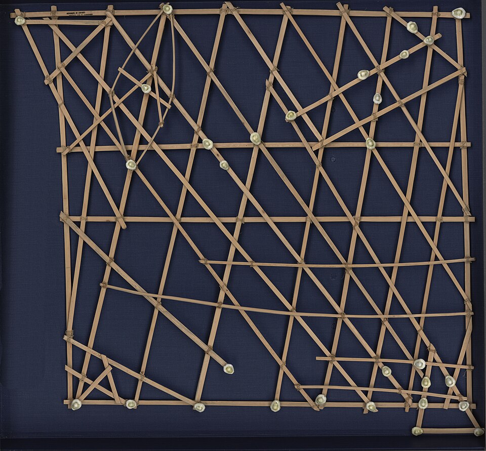
The Marshall Islanders developed stick charts, frameworks of palm ribs and cowrie shells that represented ocean swell patterns and island positions. Unlike Western maps, these charts were not carried aboard canoes but were study aids used before a voyage to memorize the pattern of swells around specific island groups. The charts encoded practical knowledge about how swells refract, reflect, and diffract around islands, creating detectable patterns that indicated the direction of land from beyond visual range.3, 11
The depth and precision of this navigational knowledge challenges any characterization of pre-literate Pacific societies as technologically unsophisticated. The system required memorizing hundreds of star positions, understanding seasonal variations in wind and current, interpreting subtle environmental cues, and integrating all of these into real-time spatial reasoning during voyages lasting weeks. This intellectual achievement, accomplished without writing, mathematics, or instruments, represents one of the most remarkable feats of applied environmental knowledge in human history.3, 12
Legacy and significance
The Polynesian settlement of the Pacific demonstrates that complex navigational technology and systematic exploration are not exclusive to literate, state-level societies. The colonization of Remote Oceania was not a haphazard process but a deliberate, multi-generational enterprise that required sophisticated vessel construction, navigational expertise, and the logistical capability to transport founding populations with sufficient genetic diversity and cultural knowledge to establish viable colonies.1, 2
Archaeological and genetic evidence together paint a picture of purposeful expansion. The "transported landscape" carried by Polynesian colonizers, including crops, livestock, and commensal species, indicates planned colonization rather than accidental discovery. The speed of the final East Polynesian dispersal, with islands separated by thousands of kilometers settled within a few centuries, suggests a self-reinforcing process in which successful voyages generated knowledge that facilitated subsequent ones.13, 2
The Polynesian navigational tradition also provides insight into human cognitive capabilities. The ability to maintain accurate spatial orientation across thousands of kilometers of featureless ocean, using only natural cues processed through a memorized knowledge framework, reveals capacities for environmental perception, spatial reasoning, and long-term memory that push the boundaries of what controlled laboratory studies might predict. As the revival of traditional voyaging continues across the Pacific, this ancient knowledge system remains both a subject of scientific study and a living cultural practice.3, 10
References
On the Road of the Winds: An Archaeological History of the Pacific Islands before European Contact
Dating the late prehistoric dispersal of Polynesians to New Zealand using the commensal Pacific rat
High-precision radiocarbon dating shows recent and rapid initial human colonization of East Polynesia
Genome-wide ancestry patterns in Rapanui suggest pre-European admixture with Native Americans