Overview
- Wind transports sediment through three distinct mechanisms — surface creep (grains > 2 mm rolling along the ground), saltation (0.1–2 mm grains bouncing in parabolic trajectories that account for 50–70 percent of total sand movement), and suspension (silt and clay particles lofted to altitudes exceeding 5 km) — with saltation initiating when wind shear velocity surpasses the Bagnold fluid threshold of approximately 0.2 m/s for typical quartz sand.
- Aeolian depositional landforms range from sand dunes covering roughly 6 percent of Earth's land surface in major sand seas (ergs) — classified into barchan, transverse, linear, and star morphologies depending on sand supply and wind regime — to loess blankets of wind-blown silt that mantle more than 10 percent of the global land area, including China's Loess Plateau at 640,000 km².
- The Sahara Desert alone emits an estimated 600–800 Tg of mineral dust per year, accounting for roughly 60 percent of global atmospheric dust loading; approximately 28 Tg of this dust reaches the Amazon Basin annually, delivering around 22,000 tonnes of phosphorus that replaces nutrients lost to tropical weathering and sustains rainforest productivity.
Aeolian geomorphology is the study of landforms and surface processes shaped by wind. Named after Aeolus, the Greek keeper of the winds, the discipline encompasses the erosion, transport, and deposition of sediment by atmospheric flow across landscapes ranging from hyper-arid sand seas to temperate agricultural plains and polar ice sheets.3, 6 Wind-sculpted features cover vast portions of Earth's surface: sand dunes and sand seas (ergs) occupy roughly 6 percent of the global land area, while loess — blankets of wind-blown silt — mantles more than 10 percent, making aeolian processes among the most spatially extensive geomorphic agents on the planet.5, 11
The scientific foundations of aeolian geomorphology were established by Ralph Alger Bagnold, whose 1941 monograph The Physics of Blown Sand and Desert Dunes provided the first rigorous quantitative treatment of wind-driven sediment transport, including the definition of saltation thresholds and the mathematical description of sand flux as a function of wind shear velocity.1 Subsequent decades brought advances in boundary-layer meteorology, remote sensing, and numerical modelling that have expanded the field far beyond its desert origins, revealing the importance of aeolian processes in dust-climate feedbacks, soil fertility, planetary geomorphology, and human land-use impacts.2, 3, 7
Mechanisms of aeolian sediment transport
Wind moves sediment through three principal mechanisms whose relative importance depends on grain size, wind velocity, and surface conditions.1, 2 The coarsest particles, generally exceeding 2 mm in diameter, are too heavy to be lifted into the airstream and instead roll or slide along the surface in a mode known as surface creep, which accounts for an estimated 5 to 25 percent of total sand transport.2, 12 Saltation is the dominant mode of sand movement, responsible for 50 to 70 percent of aeolian sediment flux.2 In saltation, grains of approximately 0.1 to 2 mm diameter are ejected from the surface at steep angles, follow parabolic trajectories typically reaching heights of a few centimetres to a few tens of centimetres, and impact the bed at shallow angles with sufficient energy to eject additional grains in a cascading chain reaction called the splash process.1, 2
Bagnold demonstrated that saltation initiates when the wind shear velocity at the surface exceeds a fluid threshold, approximately 0.2 m/s for loose quartz sand of 0.25 mm diameter.1 Once saltation is established, the sustained bombardment of the bed reduces the threshold required to maintain transport to a lower impact threshold, meaning that sand movement can persist at wind speeds below those required to start it.1, 2 The total sand transport rate scales approximately as the cube of the wind shear velocity, a relationship first proposed by Bagnold and subsequently refined by numerous investigators.1, 17
The finest particles — silt and clay grains smaller than about 0.07 mm — are transported in suspension, carried by atmospheric turbulence to altitudes that can exceed 5 km and distances of thousands of kilometres.2, 7 Unlike saltation, which is concentrated within the lowest metre of the atmosphere, suspension allows aeolian material to cross entire ocean basins. Satellite lidar measurements have documented Saharan dust plumes traversing the Atlantic Ocean, depositing an average of 28 Tg of dust per year into the Amazon Basin alone.8 The global atmosphere carries an estimated 2,000 Tg of mineral dust annually, with North Africa contributing roughly 60 percent of the total emission.9, 14
Erosional landforms
Wind erodes coherent surfaces through two primary processes: deflation, the removal of loose or weathered particles by turbulent airflow, and abrasion, the mechanical wear of rock surfaces by the impact of wind-borne sand grains.3, 13 Because saltating grains rarely rise above one metre, aeolian abrasion is concentrated in the lowest part of the wind profile, producing distinctive undercutting and fluting on exposed rock faces.1, 6
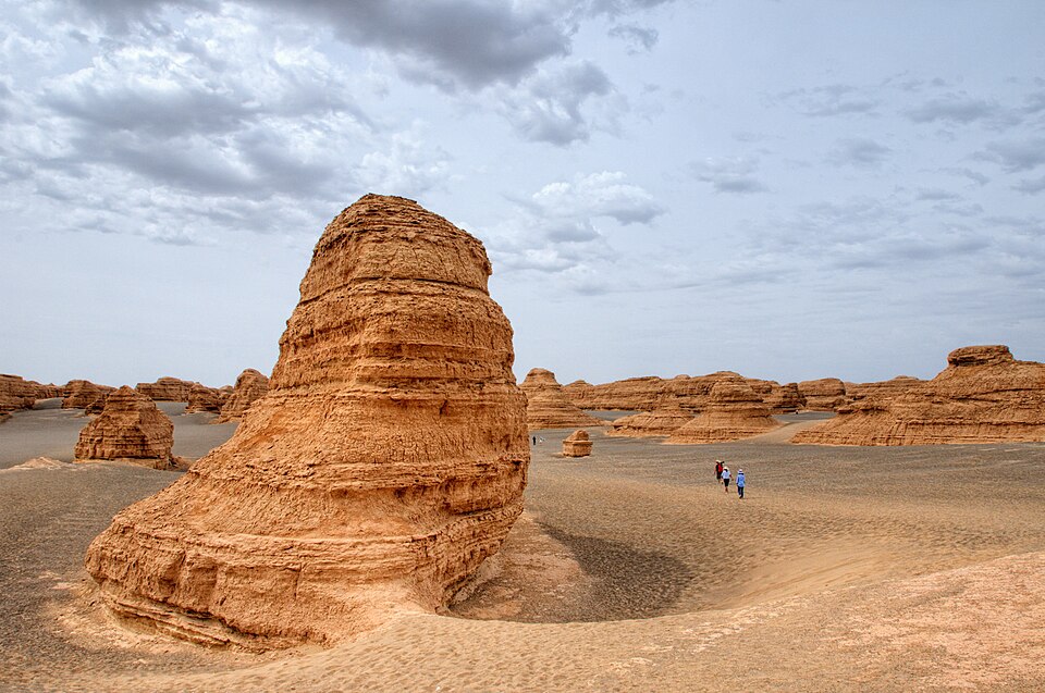
Yardangs are elongated, streamlined ridges carved from bedrock or consolidated sediment by the combined action of deflation and abrasion. They are typically three or more times longer than they are wide and, when viewed from above, resemble the hull of a boat, with a steep, blunt windward prow tapering to a narrow leeward tail.10, 13 Yardangs occur in arid regions worldwide, from the Lut Desert of Iran to the Qaidam Basin of China, where wind has been identified as the primary driver of regional-scale erosion removing hundreds of metres of sedimentary fill.10, 15 Ventifacts are individual rock clasts or bedrock protrusions that have been faceted, polished, or pitted by sand-blast abrasion, often developing flat faces (facets) and sharp edges (keels) oriented toward the prevailing wind.6, 13
Deflation hollows and basins form where wind removes fine-grained, unconsolidated material from topographic lows, creating shallow depressions that can range from a few metres to many kilometres in diameter.6, 12 The Qattara Depression in Egypt, measuring roughly 300 km long and 135 km wide with a floor 134 metres below sea level, is one of the largest deflation basins on Earth.6 Desert pavements — surfaces armoured by a layer of closely packed pebbles and cobbles — are partly a product of deflation, which selectively removes finer material and leaves behind a lag of coarser clasts too heavy for the wind to transport.19 These pavements, known as reg in Arabic and gibber in Australian usage, protect the underlying substrate from further deflation and create a negative feedback that limits continued erosion.6, 19
Sand dunes and dune morphology
Sand dunes are the most visually striking products of aeolian deposition. They form wherever wind-transported sand accumulates around an obstacle, a change in surface roughness, or a convergence in airflow, and they grow as saltating grains migrate up the windward (stoss) slope and avalanche down the steep leeward (slip) face once the angle of repose — typically 30 to 34 degrees for dry sand — is exceeded.1, 4, 5 The resulting asymmetric cross-sectional profile, with a gentle stoss slope and a steep slip face, is the fundamental morphological signature of an active dune.1
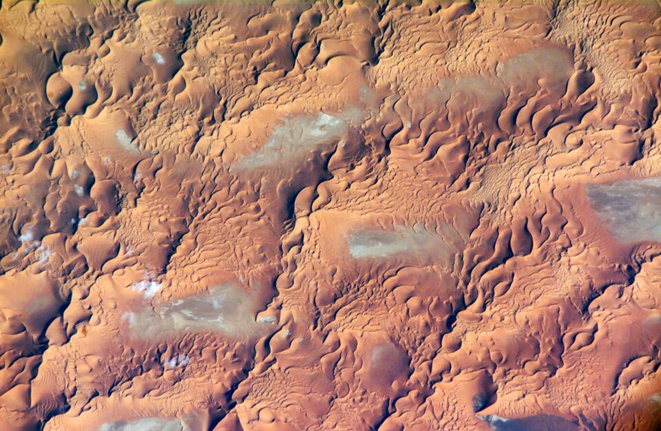
Dune morphology is controlled primarily by sand supply, wind regime, and the presence or absence of vegetation.4, 5 Barchan dunes are crescent-shaped forms with horns pointing downwind that develop where sand supply is limited and wind blows consistently from one direction; they are among the fastest-migrating dune types, advancing at rates of up to 30 metres per year.4, 18 Transverse dunes are long, sinuous ridges oriented perpendicular to the prevailing wind, forming in areas of abundant sand supply under a unidirectional wind regime.4, 5 Linear (longitudinal or seif) dunes extend as parallel ridges roughly aligned with the resultant sand transport direction, often reaching lengths of tens to hundreds of kilometres in the great sand seas of the Sahara, Arabia, and Australia; they are the most widespread dune form globally.4, 5, 18 Star dunes develop where three or more wind directions converge, producing a pyramidal central peak with radiating arms; they tend to grow vertically rather than migrate laterally and are the tallest dune type, reaching heights exceeding 300 metres in parts of the Namib and Saharan ergs.4, 6 Parabolic dunes, which are U-shaped with horns pointing upwind, form primarily in coastal and semi-arid settings where partial vegetation cover anchors the dune margins while the central body advances downwind.5, 17
Sand seas, or ergs, are large-scale accumulations of aeolian sand covering areas greater than 125 km², and collectively they occupy approximately 6 percent of the global land surface.5, 6 Approximately 85 percent of Earth's mobile sand is concentrated in ergs exceeding 32,000 km² in area, the largest being the Rub' al Khali of the Arabian Peninsula at roughly 650,000 km².6
Major dune types by global areal coverage4, 5
Loess deposits
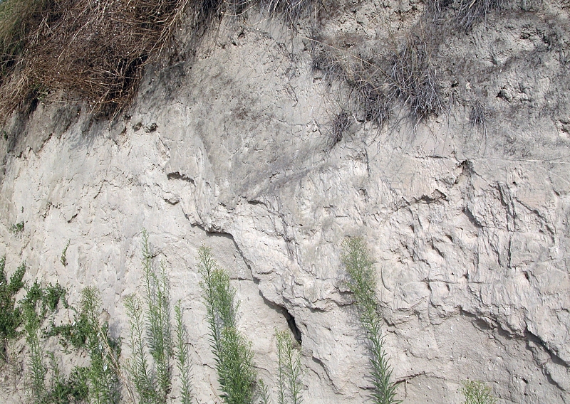
Loess is a fine-grained, wind-deposited sediment composed predominantly of silt-sized quartz particles in the 20 to 63 μm diameter range, with subordinate proportions of feldspar, ite, carbonate, and clay minerals.11, 16 Loess blankets more than 10 percent of Earth's land surface, concentrated primarily in the mid-latitudes, and reaches thicknesses exceeding 300 metres on China's Loess Plateau — an area of approximately 640,000 km² that represents the thickest and most complete terrestrial record of Quaternary climate change.11, 16
Three principal environments of loess formation have been identified.11, 16 Periglacial loess accumulated downwind of Pleistocene ice sheets, where glacial grinding produced abundant silt-sized material that was entrained by katabatic winds and deposited across shield landscapes; the thick loess deposits of the North American Great Plains and the northern European loess belt from England to Ukraine formed in this manner.11 Perimontane loess was generated by the mechanical weathering and fluvial reworking of mountain sediments, with the resulting silt deflated from broad outwash plains and deposited along mountain margins, as in the loess sequences of Central Asia.11, 16 Peridesert (or desert) loess formed on the semi-arid margins of lowland deserts, where abrasion and salt weathering break sand grains into silt-sized fragments that are subsequently lofted and transported by wind; examples include the loess deposits of the Negev Desert and the Saharan margins of North Africa.11, 16
Loess deposits are of considerable agricultural importance because they weather into deep, fertile soils with excellent moisture-holding capacity.12, 16 The most productive agricultural regions of China, Europe, Argentina, and the central United States are developed on loess-derived soils.11 However, loess is also highly erodible; when stripped of vegetation, loess landscapes are vulnerable to severe gully erosion, as dramatically illustrated by the deeply dissected terrain of the Chinese Loess Plateau, where erosion rates can exceed 10,000 tonnes per km² per year.11, 12
The global dust cycle
Mineral dust is the finest fraction of aeolian sediment, consisting of clay and silt particles that are lofted into suspension and transported over intercontinental distances by atmospheric circulation.7, 9 The global atmosphere carries approximately 2,000 Tg of mineral dust per year, with emissions dominated by a small number of hyperarid source regions.9, 14 North Africa is by far the largest single source, contributing an estimated 600 to 800 Tg per year — roughly 60 percent of the global total — with the Bodélé Depression of Chad identified as the single most active point source on Earth.7, 9 Asia, including the Taklamakan and Gobi deserts, contributes the second-largest share at approximately 10 to 15 percent of global emissions.9, 14
Atmospheric dust has far-reaching effects on Earth's climate and biogeochemical cycles.7, 9 Dust particles scatter and absorb solar radiation, alter cloud microphysics by serving as cloud condensation and ice nuclei, and modulate the radiative energy balance of the atmosphere at both regional and global scales.2, 7 Upon deposition, mineral dust delivers nutrients — particularly iron and phosphorus — to remote ecosystems. CALIPSO satellite lidar measurements have shown that an average of 28 Tg of Saharan dust is deposited in the Amazon Basin each year, delivering approximately 22,000 tonnes of phosphorus that replaces nutrients lost to intense tropical weathering and rainfall, effectively sustaining the productivity of the world's largest rainforest.8 Similarly, iron-bearing Saharan dust deposited in the Atlantic and Southern Oceans fertilizes phytoplankton growth, influencing marine primary productivity and the oceanic carbon cycle.7, 9
Major global dust source regions9, 14
| Source region | Estimated emission (Tg/yr) | Share of global total |
|---|---|---|
| North Africa (Sahara) | 600–800 | ~60% |
| Middle East & Central Asia | 150–300 | ~15% |
| East Asia (Gobi, Taklamakan) | 100–200 | ~10% |
| Southern Hemisphere deserts | 50–100 | ~5% |
| Other sources | 100–200 | ~10% |
Controls on aeolian activity
The intensity and spatial distribution of aeolian processes are governed by the interplay of climate, vegetation, sediment supply, and surface characteristics.3, 6 Wind speed is the most direct control: because the sand transport rate scales with the cube of shear velocity, even modest increases in wind speed produce large increases in sediment flux.1, 17 However, aridity and vegetation cover are equally important in determining whether wind can access erodible material at the surface. Vegetation reduces wind speed at the ground through aerodynamic roughness, traps saltating grains, binds soil with root networks, and adds organic matter that increases cohesion; as a result, aeolian activity is strongly suppressed wherever vegetation cover exceeds approximately 15 to 30 percent.3, 6, 20
Soil moisture dramatically raises the threshold wind speed for particle entrainment because capillary forces between wet grains resist detachment.2, 12 Surface crusting — whether by biological soil crusts (cryptogamic crusts), mineral precipitation, or raindrop impact — further protects surfaces from deflation by creating a cohesive layer that must be broken before individual grains can be mobilised.6, 13 Conversely, disturbance of these protective layers by grazing, vehicle traffic, or cultivation can dramatically increase aeolian erosion, a process that is central to the dynamics of desertification in dryland margins worldwide.6, 20
On geological timescales, the expansion and contraction of aeolian activity is closely linked to glacial-interglacial climate cycles.3, 11 During Pleistocene glacial periods, cooler temperatures, reduced precipitation, lower sea levels (exposing continental shelves as sediment sources), and stronger atmospheric circulation combined to produce rates of dust deposition in ice cores and marine sediments that were two to five times higher than Holocene values.7, 11 The thick loess sequences of China, Europe, and the Americas preserve a detailed record of these oscillations, with alternating loess layers (glacial) and palaeosol horizons (interglacial) spanning millions of years.11, 16
Aeolian processes beyond Earth
Aeolian geomorphology is not confined to Earth. Wind-driven landforms have been identified on Mars, Venus, and Titan, making aeolian processes one of the most universal geomorphic agents in the solar system.2 Mars possesses the most extensively documented extraterrestrial aeolian landscape, with orbital and rover imagery revealing vast dune fields, yardangs, ventifacts, ripples, and dust-devil tracks across the planet's surface.2 The Martian atmosphere, although only about 1 percent the density of Earth's, supports saltation and suspension because the lower gravity (3.7 m/s² versus 9.8 m/s²) reduces the threshold wind speeds required to mobilise particles.2 Global dust storms on Mars can loft fine particles to altitudes exceeding 40 km and encircle the entire planet within days, profoundly affecting surface temperatures and atmospheric dynamics.2
Saturn's moon Titan hosts extensive equatorial dune fields composed not of silicate sand but of organic particles — likely tholins — derived from photochemical reactions in Titan's dense nitrogen-methane atmosphere.2 Radar imagery from the Cassini spacecraft revealed that these dunes are predominantly longitudinal forms extending for hundreds of kilometres, morphologically similar to linear dunes on Earth, though formed under radically different atmospheric and compositional conditions.2 Venus, with its dense CO&sub2; atmosphere and surface pressures ninety times those of Earth, also displays aeolian features including wind streaks and possible dune-like forms, although the extreme surface conditions limit detailed investigation.2
Human impacts and desertification
Human activities have profoundly altered aeolian processes across the globe, both intensifying wind erosion through land-use change and, in some cases, deliberately managing aeolian landscapes to mitigate sand and dust hazards.6, 20 Overgrazing, deforestation, and the conversion of dryland grasslands to rain-fed agriculture remove vegetation cover and disturb protective soil crusts, exposing bare surfaces to deflation and dramatically increasing dust emission.20 The Dust Bowl of the 1930s in the American Great Plains remains one of the most severe examples of human-accelerated wind erosion, when ploughing of native grasslands combined with prolonged drought produced catastrophic soil loss and massive dust storms that darkened skies across the eastern United States.6, 12
The desiccation of the Aral Sea, driven by Soviet-era irrigation diversions, exposed tens of thousands of square kilometres of saline lake bed to deflation, generating toxic dust storms that have degraded air quality and human health across Central Asia.6, 20 In the Sahel, decades of research have debated the relative roles of climate variability and human land use in driving desertification and increased dust emission, with current understanding emphasising the interaction between the two.7, 20
Mitigation strategies for aeolian hazards include the establishment of shelter belts (rows of trees that reduce surface wind speed), sand fences that trap migrating sand, chemical or biological stabilisation of dune surfaces, and the restoration of vegetation cover on degraded lands.3, 6 China's "Green Great Wall" programme, initiated in 1978, aims to plant a 4,500-km belt of forest across northern China to halt the southward advance of the Gobi Desert and reduce dust-storm frequency in Beijing and other cities.6, 20 Understanding the thresholds and feedbacks that govern aeolian activity is essential for predicting how dryland landscapes will respond to projected changes in temperature, precipitation, and land use under future climate scenarios.3, 9, 20
References
Mineral dust aerosols over the Sahara: Meteorological controls on emission and transport and implications for modeling
The fertilizing role of African dust in the Amazon rainforest: A first multiyear assessment based on CALIPSO lidar observations
Contribution of the world's main dust source regions to the global cycle of desert dust
A numerical study of the contributions of dust source regions to the global dust budget