Overview
- Approximately 31 percent of the world’s ice-free coastline is sandy beach, and satellite analysis shows that 24 percent of those sandy shores are eroding at rates exceeding 0.5 metres per year, driven by wave action, longshore drift, tidal currents, and reduced sediment supply from dammed rivers.
- Coastal landforms span an enormous morphological range — from erosional features such as sea cliffs, shore platforms, sea stacks, and sea caves shaped by hydraulic action and abrasion, to depositional features including barrier islands, spits, tombolos, and deltas built by longshore and cross-shore sediment transport.
- Global mean sea level rose 0.20 metres between 1901 and 2018 at an accelerating rate (3.7 mm per year during 2006–2018), and IPCC projections indicate that continued rise will intensify coastal erosion, inundate low-lying deltas, and threaten the approximately 680 million people living in coastal zones below 10 metres elevation.
Coastal geomorphology is the study of landforms and processes at the interface between land and sea. Coastlines occupy a narrow but geomorphically dynamic zone where wave energy, tidal currents, wind, weathering, and biological activity interact to erode, transport, and deposit sediment, producing an extraordinary diversity of landforms ranging from vertical sea cliffs and shore platforms to expansive sandy beaches, barrier islands, deltas, and coral reefs.1, 2 Satellite surveys estimate that approximately 31 percent of the world's ice-free shoreline consists of sandy beaches, and that 24 percent of those sandy coasts are eroding at rates exceeding 0.5 metres per year.3 The discipline therefore has immediate relevance to the roughly 680 million people who live in low-lying coastal zones below 10 metres elevation, a population expected to exceed one billion by 2050.7
The scientific study of coastal processes traces its modern origins to the mid-twentieth century, when researchers began applying wave mechanics, sediment transport equations, and quantitative surveying to shoreline change. Foundational work by Per Bruun on equilibrium beach profiles and shoreline retreat under sea-level rise, by Paul Komar on longshore sediment transport, and by Andrew Short and Gerhard Masselink on beach morphodynamics established the theoretical frameworks still in use today.4, 8, 15 Coastal geomorphology now draws on remote sensing, numerical modelling, and global datasets to address questions of accelerating sea-level rise, increasing storm intensity, and the human modification of sediment budgets that together make the coast one of the most rapidly changing environments on Earth.6, 14
Wave processes and energy delivery
Waves are the primary agent of geomorphic work on most coastlines, delivering energy generated by distant winds across entire ocean basins to a narrow surf zone where that energy is concentrated and expended. Ocean waves are generated by wind stress on the sea surface; the height, period, and wavelength of the resulting waves depend on wind speed, duration, and fetch (the distance of open water over which the wind blows).2, 11 As waves propagate from deep water toward shore, they undergo a series of transformations. When the water depth decreases to approximately half the wavelength, the waves begin to interact with the seabed, slowing down and decreasing in wavelength while their height increases — a process called shoaling.1, 2
Wave refraction occurs when waves approach a coastline obliquely or encounter variations in nearshore bathymetry. The portion of the wave crest in shallower water slows relative to the portion still in deeper water, causing the crest to bend toward alignment with the depth contours. On irregular coastlines, refraction concentrates wave energy on headlands while dispersing it in embayments, a pattern that drives preferential erosion of headlands and deposition in bays, gradually smoothing the plan-form geometry of the coast.1, 2 Wave diffraction — the lateral spreading of wave energy around obstacles such as breakwaters, headlands, or islands — further redistributes energy in the nearshore zone and influences patterns of sediment deposition in the lee of such features.2
When waves enter water shallow enough that their steepness exceeds a critical threshold (approximately a height-to-wavelength ratio of 1:7), they break, dissipating their energy as turbulence in the surf zone. The type of breaker — spilling, plunging, collapsing, or surging — depends on the wave steepness and beach gradient, and each type delivers energy to the coast in a distinct manner.2, 8 Plunging breakers on steep beaches generate intense localized forces and are particularly effective at mobilising sediment, while spilling breakers on gentle gradients dissipate their energy over a broader surf zone.8
Erosional landforms and rocky coasts
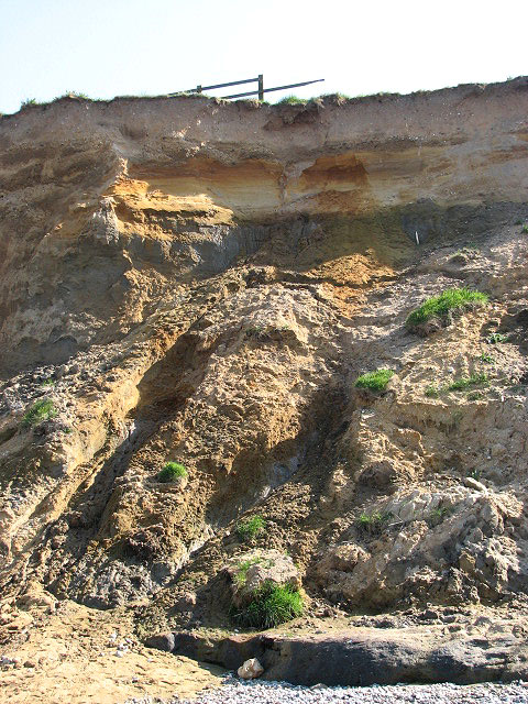
Where resistant bedrock is exposed to wave attack, the coastline develops a suite of erosional landforms whose morphology reflects the interplay of rock strength, structure, and the intensity of wave energy. Wave erosion operates through four principal mechanisms: hydraulic action (the force of water and compressed air driven into rock joints), abrasion (the grinding of rock surfaces by wave-borne sediment), attrition (the mutual wearing of sediment clasts in transport), and solution (chemical dissolution, particularly of calcareous rocks).1, 13 Of these, hydraulic action and abrasion are the most important in removing rock from coastal cliffs.13
Sea cliffs are the most widespread erosional landform, forming wherever waves undercut a rock face faster than subaerial weathering and mass wasting can reduce the cliff angle. Cliff retreat rates vary enormously with lithology: soft glacial-till cliffs on the Holderness coast of England retreat at 1–2 metres per year, chalk cliffs at 0.1–1 metre per year, and hard granite cliffs at only millimetres per decade.13, 14 As a cliff retreats, it leaves behind a gently sloping shore platform — a wave-cut surface at approximately the level of mean tide that widens over time and progressively attenuates incoming wave energy, creating a negative feedback that reduces the rate of further cliff retreat.1, 13
Where differential erosion exploits zones of structural weakness such as faults, joints, or bedding planes, a variety of smaller-scale landforms develops. Sea caves form where waves enlarge joints or fault zones in a cliff face; if two caves on opposite sides of a headland intersect, a sea arch results. The eventual collapse of an arch leaves an isolated pillar of rock known as a sea stack, a transient landform that itself will ultimately succumb to wave attack.1, 2 Blowholes, geos (narrow inlets along faults), and wave-cut notches at the cliff base are additional expressions of selective erosion along structural weaknesses.1
Sediment transport and the coastal budget
The distribution of sediment along a coastline is governed by the coastal sediment budget — the balance between inputs (river discharge, cliff erosion, offshore sources, biogenic production) and outputs (offshore loss, longshore transport out of the cell, aeolian removal, human extraction). Where inputs exceed outputs, the coast accretes; where outputs dominate, it erodes.2, 11 Understanding sediment budgets is therefore fundamental to predicting shoreline change.
Longshore sediment transport (littoral drift) is the dominant mechanism for redistributing sand along open coasts. When waves approach the shore at an oblique angle, the swash carries sediment up the beach face at that angle, but the backwash returns it directly downslope under gravity, producing a net transport of sediment along the coast in the direction of wave approach.2, 15 The CERC formula, developed by the US Army Corps of Engineers, relates the longshore transport rate to the longshore component of wave power, and remains the most widely used predictive equation despite known limitations in accuracy.15 Annual longshore transport rates can exceed one million cubic metres along wave-exposed sandy coasts.15, 20
Cross-shore transport — the movement of sediment perpendicular to the shoreline — is equally important, particularly in controlling seasonal and storm-driven changes in beach profile. During high-energy storm conditions, steep waves strip sand from the beach face and deposit it in offshore bars, creating a flattened storm profile. During calmer swell conditions, the gentler waves return sand onshore, rebuilding the berm and steepening the profile.8, 2 This cyclic exchange between the subaerial beach and the nearshore bar system is a fundamental feature of sandy beach morphodynamics.8
Rivers are the single largest source of sediment to the world's coasts, delivering approximately 20 billion tonnes per year under pre-human conditions. Damming has reduced this flux by an estimated 25–30 percent, trapping sediment in reservoirs and starving downstream coasts of supply, with consequences that include accelerated erosion of deltas and barrier beaches worldwide.18, 21
Depositional landforms
Where sediment supply is abundant relative to wave energy, the coast builds outward, creating a wide range of depositional landforms. Beaches themselves are the most familiar: accumulations of sand, gravel, or cobbles shaped by wave action into profiles that adjust dynamically to wave conditions. Beach morphodynamics research, following the framework of Wright and Short (1984) as extended by Masselink and Short (2002), recognises a spectrum of beach states from fully dissipative (wide, flat beaches with multiple bars) to fully reflective (steep, narrow beaches with no bars), with the prevailing state controlled by wave height, wave period, and sediment grain size.8
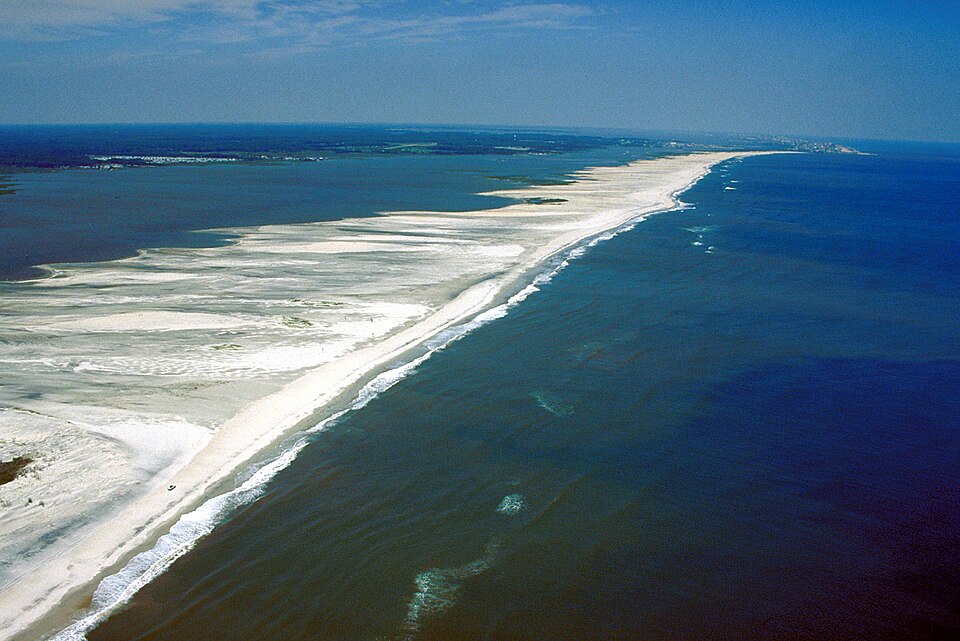
Spits are elongate ridges of sand or gravel that extend from the mainland into open water, formed where longshore drift carries sediment past a change in coastline orientation such as a river mouth or estuary entrance. Where a spit connects the mainland to an offshore island, the resulting feature is called a tombolo.1, 20 Barrier islands are long, narrow sand bodies that run parallel to the mainland shore, separated from it by a lagoon or bay. They are among the most dynamic of all coastal landforms, migrating landward through overwash and inlet processes as sea level rises or sediment supply diminishes.10 Barrier islands front approximately 10 percent of the world's open-ocean coastline and are especially well developed along the Gulf and Atlantic coasts of the United States, where they protect the mainland from direct wave attack but are themselves highly vulnerable to storms.10, 20
Deltas form where rivers deliver sediment to the coast faster than waves and tides can redistribute it. The morphology of a delta reflects the relative dominance of fluvial, wave, and tidal processes: river-dominated deltas (such as the Mississippi) extend seaward in elongate distributary channels, wave-dominated deltas (such as the São Francisco) develop smooth, arcuate shorelines, and tide-dominated deltas (such as the Ganges-Brahmaputra) are dissected by funnel-shaped tidal channels.2, 20
Tidal and estuarine landforms
Tides exert a first-order control on coastal morphology by determining the range of elevations subject to wave action, modulating current velocities in inlets and estuaries, and governing the extent and duration of inundation of intertidal flats and marshes. The tidal range — the vertical difference between high and low tide — varies from less than one metre on microtidal coasts (e.g. the Mediterranean) to more than ten metres on macrotidal coasts (e.g. the Bay of Fundy), and this range fundamentally controls the width of the intertidal zone and the type of landforms that develop within it.1, 2
Estuaries, where rivers meet the sea, are among the most geomorphically complex coastal environments. They are typically classified by their origin (drowned river valleys, fjords, bar-built lagoons, or tectonic estuaries) and by the relative dominance of fluvial and tidal energy. In tide-dominated estuaries, strong tidal currents sculpt the channel into a funnel-shaped plan form, build extensive tidal flats and sand bars, and drive bidirectional (flood and ebb) sediment transport.2, 20
Salt marshes and mangrove forests occupy the upper intertidal zone on low-energy, sediment-rich coasts. These vegetated coastal wetlands trap fine-grained sediment and organic matter, building elevation at rates that can keep pace with moderate sea-level rise. Mangrove root networks reduce tidal current velocities by up to 60 percent, creating a positive bio-morphodynamic feedback in which sediment accumulation promotes vegetation growth, which in turn enhances further trapping.16, 17 Salt marshes dissected by tidal creeks can accumulate sediment at rates of 1–10 millimetres per year, although this rate depends on suspended sediment concentration, tidal range, and marsh elevation relative to mean high water.17 These ecosystems provide critical coastal protection by attenuating wave energy and reducing storm surge, with the loss of a 100-metre-wide fringe of mangrove forest estimated to increase wave heights reaching the shore by 50–70 percent.16
Coral reef coasts
Coral reefs are biogenic structures built by the accumulation of calcium carbonate skeletons secreted by reef-building corals and coralline algae, and they exert a profound influence on the geomorphology of tropical coastlines. Reefs function as natural breakwaters, dissipating 86–97 percent of incident wave energy before it reaches the shore and thereby protecting low-lying coastlines from erosion and storm damage.9, 19 The sediment produced by the physical and biological breakdown of reef organisms is the primary source of beach material on reef-fringed coasts, and the rate of carbonate sediment production by a healthy reef typically ranges from 1 to 10 kilograms of calcium carbonate per square metre per year.9
.jpg)
.jpg)
Reef islands — low-lying accumulations of reef-derived sediment on reef flats — are home to hundreds of thousands of people across the Pacific and Indian Oceans. Despite widespread concern that sea-level rise will submerge these islands, multi-decadal shoreline surveys show that the majority of reef islands have remained stable or increased in area over the past 50 years, because sediment production and wave-driven transport can sustain island growth if the reef ecosystem remains healthy.22 However, coral reef degradation from ocean warming, acidification, and human impacts threatens this sediment supply. Mass coral bleaching events, which have become more frequent and severe as sea surface temperatures have risen, reduce reef accretion rates and diminish the structural complexity that dissipates wave energy, potentially triggering a transition from coastal accretion to erosion on reef-fringed shores.19
Sea-level rise and coastal change
Sea-level change is the most pervasive driver of long-term coastal evolution. During the Last Glacial Maximum approximately 20,000 years ago, global mean sea level was roughly 125 metres lower than present, exposing vast continental shelves and extending coastlines far seaward. The subsequent postglacial transgression drowned river valleys to form estuaries, flooded low-gradient coasts to create barrier island systems, and inundated coral reef platforms, fundamentally reshaping coastal morphology worldwide.1, 6
In the modern era, global mean sea level rose by 0.20 metres between 1901 and 2018, with the rate of rise accelerating from 1.3 millimetres per year over 1901–1990 to 3.7 millimetres per year during 2006–2018.6 The IPCC Sixth Assessment Report projects a further rise of 0.28–1.01 metres by 2100 depending on emissions scenario, with the possibility of exceeding 2 metres under high-end ice-sheet instability scenarios.6, 7 The geomorphic consequences of this rise are profound: higher water levels increase wave energy reaching the shore, shift the zone of wave attack upward on coastal cliffs, steepen nearshore profiles, and increase the frequency of coastal flooding.14
Global mean sea level rise: observed acceleration6
The Bruun Rule, proposed in 1962 and refined in subsequent decades, was the first quantitative model linking sea-level rise to shoreline retreat. It predicts that for every unit of sea-level rise, a sandy shore will retreat landward by a distance equal to the rise divided by the average slope of the active beach profile — typically 50 to 100 times the vertical rise.4 Although the Bruun Rule provided an influential conceptual framework, it has been widely criticised for its restrictive assumptions (two-dimensional profile equilibrium, no longshore transport, no sediment sources or sinks), and empirical tests have shown poor agreement between predicted and observed retreat on many coastlines.5 Modern approaches to projecting coastal retreat increasingly rely on process-based numerical models that couple wave transformation, sediment transport, and morphological change in three dimensions.12, 14
Human impacts on coastal systems
Human activities have fundamentally altered coastal sediment budgets and morphological processes on a global scale. Dam construction on rivers has reduced the sediment flux reaching the coast by an estimated 5 billion tonnes per year — roughly 25–30 percent of the pre-anthropogenic total — starving deltas and beaches of the material they need to maintain their form against ongoing wave erosion.18 The consequences are starkly visible in the world's major deltas: the Nile Delta, deprived of sediment since the completion of the Aswan High Dam in 1970, is subsiding and retreating at rates of up to 100 metres per year along some segments, while the Mississippi Delta loses approximately 65 square kilometres of wetland per year to a combination of sediment starvation, subsidence, and sea-level rise.18, 21
Coastal engineering structures — groins, jetties, seawalls, and breakwaters — interrupt longshore sediment transport and alter patterns of erosion and deposition, often solving a local problem at the expense of creating or exacerbating erosion on adjacent shores. Jetties at harbour entrances and tidal inlets trap sand on their updrift side while starving the downdrift coast, a pattern documented at hundreds of locations worldwide.20 Seawalls protect the land behind them but reflect wave energy, increasing scour at their base and preventing the cliff or dune from supplying sediment to the beach, ultimately leading to narrowing or loss of the beach in front of the structure.1, 20
Sand mining for construction aggregate removes sediment directly from beaches, dunes, and rivers, further reducing coastal supply. An estimated 40–50 billion tonnes of sand and gravel are extracted globally each year, making aggregate the most mined material on Earth, and a substantial fraction of this extraction occurs in coastal and riverine environments where it directly reduces the sediment available for natural beach maintenance.18 Beach nourishment — the artificial placement of sand on eroding shores — has emerged as the dominant soft-engineering response, but it is expensive (typically US$5–15 per cubic metre of placed sand), requires periodic replenishment, and draws sand from offshore or inland sources whose own depletion may have ecological consequences.20
Coastal classification
Geomorphologists have proposed numerous schemes for classifying coastlines according to their dominant processes, morphology, or geological setting. One widely used framework distinguishes between leading-edge coasts (those on active tectonic margins, such as the Pacific coast of the Americas, characterised by narrow shelves, steep cliffs, and limited sediment supply) and trailing-edge coasts (those on passive margins, such as the US Atlantic coast, characterised by wide continental shelves, barrier islands, and extensive sediment deposits).20, 1 This tectonic classification captures first-order differences in coastal morphology that persist over millions of years.20
A process-based classification distinguishes wave-dominated, tide-dominated, and river-dominated coasts. Wave-dominated coasts develop sandy beaches, barrier islands, and wave-built spits; tide-dominated coasts are characterised by extensive tidal flats, dendritic tidal channel networks, and funnel-shaped estuaries; and river-dominated coasts feature prograding deltas and muddy shorelines.2 In practice, most coasts are influenced by all three forcing agents to varying degrees, and the relative importance of each can change over time with shifts in climate, sea level, and sediment supply.2, 11 The nearshore slope — the gradient of the seabed in the zone where waves transform and break — provides an additional global-scale classification parameter, with steeper slopes associated with reflective beach behaviour and gentler slopes with dissipative conditions, as mapped by global datasets covering over 1.4 million coastal transects.12
References
The Bruun Rule of erosion by sea-level rise: a discussion on large-scale two- and three-dimensional usages
Wave- and tidally-driven flow and sediment flux across a fringing coral reef: Southern Molokai, Hawaii
Mangrove forests: Resilience, protection from tsunamis, and responses to global climate change
Predicting the terrestrial flux of sediment to the global ocean: a planetary perspective
The dynamic response of reef islands to sea-level rise: evidence from multi-decadal analysis of island change in the central Pacific