Overview
- Continental shelves are the submerged extensions of continental landmasses, averaging roughly 65 kilometres in width and reaching depths of approximately 130 metres at the shelf break, where the gentle gradient of the shelf steepens abruptly into the continental slope.
- During Pleistocene glacial maxima, when sea level dropped by as much as 120 to 130 metres, continental shelves were exposed as dry land, creating land bridges such as Beringia (connecting Asia to North America), Doggerland (connecting Britain to continental Europe), and Sundaland (linking mainland Southeast Asia to the Indonesian archipelago).
- Continental shelves are disproportionately important to human economies, hosting the majority of the world's marine fisheries and containing vast reserves of petroleum, natural gas, and mineral resources, while the United Nations Convention on the Law of the Sea provides the legal framework for nations to claim sovereign rights over their adjacent shelf resources.
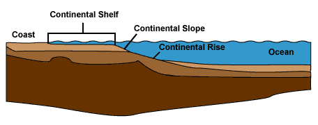
The continental shelf is the submerged margin of a continent, extending from the shoreline seaward to the shelf break, where the gentle gradient of the shelf steepens markedly into the continental slope. Continental shelves are geologically part of the continents — underlain by continental crust, blanketed by sediment derived from the adjacent landmass, and exposed as dry land during intervals of low sea level. Although they comprise only about eight percent of the ocean floor by area, continental shelves are disproportionately important: they host the most productive marine ecosystems, contain vast reserves of petroleum and minerals, and have played a decisive role in the dispersal of terrestrial species, including humans, during Pleistocene glaciations.1, 11
Definition and dimensions
The continental shelf is defined as the zone of relatively gentle seabed gradient extending from the low-tide shoreline to the shelf break, the point where the gradient increases sharply — typically from less than 0.1 degrees to 3–6 degrees — marking the transition to the continental slope. The average width of the world's continental shelves is approximately 65 kilometres, though this figure conceals enormous variation. Off the Atlantic coast of Argentina, the shelf extends more than 600 kilometres seaward; off the Pacific coast of South America, where the continental margin is a subduction zone, the shelf may be only a few kilometres wide or effectively absent.1, 15
The average depth at the shelf break is approximately 130 metres, a figure that closely corresponds to the magnitude of sea level drop during Pleistocene glacial maxima. This correspondence is not coincidental: the modern shelf break is, in many places, the former shoreline during glacial lowstands, shaped by wave erosion and sediment deposition at a time when sea level was far lower than today. The shelf surface is typically smooth and gently inclined, with gradients averaging about 0.1 degrees (approximately 2 metres of depth increase per kilometre), though relict features from glacial and subaerial exposure may produce local irregularities including drowned river valleys, moraine ridges, and sand ridges.1, 14
Geology and sedimentary cover
Continental shelves are underlain by continental crust, distinguishing them from the oceanic crust of the deep ocean floor. The shelf typically consists of a basement of crystalline or metamorphic rock overlain by a wedge of sedimentary strata that thickens seaward, reaching several kilometres in thickness at mature passive margins such as the eastern seaboard of North America or the coast of West Africa. These sedimentary sequences record the history of sea level fluctuation, tectonic subsidence, and sediment supply along the margin and are the primary targets of offshore petroleum exploration.2, 8
The surface sediments of continental shelves are remarkably varied. Kenneth Emery's global survey in 1968 established that approximately 70 percent of shelf surfaces are covered by relict sediments — deposits left behind during former low sea level stands and not in equilibrium with modern hydrodynamic conditions. These relict sediments include coarse sand, gravel, and even subaerial soils that were deposited when the shelf was exposed as coastal plain. The remaining 30 percent is covered by modern sediments actively supplied by rivers, biogenic production, or reworking by waves and currents. In tropical regions, shelf sediments may be dominated by carbonate material — skeletal fragments of corals, foraminifera, mollusks, and calcareous algae — rather than the terrigenous (land-derived) clastics that predominate at higher latitudes.14
Continental margin anatomy
The continental shelf is the shallowest component of the broader continental margin, which encompasses the full transition from continent to ocean floor. Below the shelf break, the continental slope descends at a much steeper gradient — typically 3 to 6 degrees but locally exceeding 20 degrees — to depths of 1,500 to 3,500 metres. The slope is frequently incised by submarine canyons, some of which rival the Grand Canyon in scale, carved by turbidity currents carrying sediment from the shelf to the deep sea.15, 17
At the base of the continental slope, the gradient decreases again as the slope transitions into the continental rise, a broad, gently sloping apron of sediment accumulated at the foot of the margin. The continental rise is composed primarily of turbidites — graded sedimentary layers deposited by density-driven flows that originated on the shelf or slope — and hemipelagic muds that settled from the overlying water column. The rise grades imperceptibly into the abyssal plain, marking the boundary between continental and oceanic domains. Together, the shelf, slope, and rise constitute the passive continental margin, characteristic of the Atlantic-type ocean basin where tectonic activity is minimal.8, 17
At active margins, where oceanic crust is being subducted beneath the continental plate, the anatomy differs markedly. The shelf is typically narrow, the slope steep and tectonically deformed, and the rise may be absent or replaced by an accretionary wedge of scraped-off oceanic sediment or by a deep-sea trench. The Pacific margins of South America and Japan are examples of such active-margin shelves.8
Relationship to sea level changes
The most dramatic transformations of continental shelves occur during sea level fluctuations driven by the growth and decay of continental ice sheets. During the Last Glacial Maximum, approximately 21,000 years ago, global sea level stood roughly 120 to 130 metres below its present position, exposing nearly all of the world's continental shelves as dry land.3, 10 The consequences for geography, ecology, and human migration were profound.
The most celebrated example is Beringia, the land bridge that connected northeastern Asia to northwestern North America when the shallow Bering and Chukchi seas were drained by falling sea level. Beringia was not merely a narrow isthmus but a broad, vegetated plain up to 1,600 kilometres wide from north to south, supporting a distinctive grassland-steppe ecosystem that hosted woolly mammoths, horses, and bison. It was across this exposed shelf that humans first entered the Americas, probably between 20,000 and 15,000 years ago, although the exact timing and route remain subjects of active research.7
Doggerland was the now-submerged landmass that connected the British Isles to continental Europe across what is today the southern North Sea. At the glacial maximum, Doggerland was a low-lying landscape of river valleys, marshes, and coastal plains inhabited by Mesolithic hunter-gatherers. Archaeological evidence — including worked flints, bone tools, and even human remains — has been dredged from the North Sea floor by fishing trawlers for over a century. Detailed seismic surveys have mapped Doggerland's submerged topography, revealing river systems, lake basins, and a coastline progressively drowned by rising seas between approximately 10,000 and 8,000 years ago. The catastrophic Storegga Slide tsunami, generated by a massive submarine landslide off Norway around 8,150 years ago, may have inundated the last remnants of Doggerland.5
Sundaland was the enormous exposed continental shelf of Southeast Asia that connected the Malay Peninsula, Borneo, Sumatra, and Java into a single landmass during glacial periods. At its maximum extent, Sundaland doubled the area of mainland Southeast Asia, and its river systems — now drowned beneath the South China Sea and Java Sea — were among the largest on Earth. The flooding of Sundaland during postglacial sea level rise fragmented continuous populations of plants, animals, and humans into the island archipelagos of modern Indonesia and the Philippines, making Sundaland a key biogeographic boundary.6
The exposure and reflooding of continental shelves is recorded in the stratigraphic record as repeated cycles of transgression (sea level rise, drowning the shelf) and regression (sea level fall, exposing it). These cycles produce the characteristic stacking patterns of shallow-marine sedimentary sequences described by sequence stratigraphy, a discipline founded on the seismic interpretation of shelf and margin deposits by Peter Vail and colleagues in the 1970s.2
Economic resources
Continental shelves are among the most economically productive zones on the planet. Their shallow, well-lit, nutrient-rich waters support the vast majority of the world's marine fisheries. Although shelf waters cover less than 10 percent of the ocean surface, they account for more than 90 percent of global fish catch, because the combination of nutrient upwelling, river discharge, and photosynthetically active depths sustains high primary productivity and dense food webs. The major fishing grounds of the world — the Grand Banks off Newfoundland, the North Sea, the East China Sea, and the upwelling zones off Peru and West Africa — are all located on or adjacent to continental shelves.11
Petroleum and natural gas are the most economically valuable resources extracted from continental shelves. The thick sedimentary wedges deposited on passive margins over tens of millions of years contain source rocks rich in organic matter, reservoir rocks with sufficient porosity and permeability to store hydrocarbons, and structural or stratigraphic traps that concentrate them into recoverable accumulations. Offshore production accounts for a substantial and growing fraction of global oil and gas output, with major producing provinces on the shelves of the Gulf of Mexico, the North Sea, the Persian Gulf, West Africa, Brazil, and Southeast Asia.16 Advances in drilling technology have extended production from the shallow shelf into deep-water slope and rise environments, but the shelf remains the most accessible and least costly offshore domain.
Other shelf resources include placer deposits of heavy minerals (titanium, zircon, and tin in beach and nearshore sands), phosphorite nodules formed by chemical precipitation on outer shelves, and aggregate (sand and gravel) dredged for construction. In some regions, freshwater aquifers extend offshore beneath the shelf surface, representing a largely untapped resource.12
Marine biodiversity hotspots
The ecological richness of continental shelves stems from their position at the intersection of terrestrial nutrient supply, solar illumination, and dynamic oceanic circulation. Shelf waters lie almost entirely within the photic zone, where sunlight penetrates to the seabed, supporting benthic photosynthetic communities including seagrass meadows, kelp forests, and, in tropical regions, coral reefs. These habitats are among the most biodiverse marine ecosystems on Earth and provide critical nursery grounds for commercially important fish and invertebrate species.11
Nutrient enrichment on shelves occurs through multiple pathways: river discharge delivers dissolved nutrients and organic matter from terrestrial weathering; upwelling along certain shelf margins brings deep, nutrient-rich water to the surface; and tidal mixing prevents stratification and maintains nutrient availability in the photic zone. The interaction of these processes produces the biological productivity that sustains the food webs from plankton to marine mammals. Continental shelf ecosystems are, however, highly vulnerable to human impacts including overfishing, habitat destruction by bottom trawling, pollution, and the effects of climate change including warming, acidification, and deoxygenation.11, 13
UNCLOS and legal continental shelf claims
The legal framework governing the rights of coastal states over their continental shelves is established by the United Nations Convention on the Law of the Sea (UNCLOS), adopted in 1982 and entering into force in 1994. Under UNCLOS, every coastal state has sovereign rights over the natural resources of its continental shelf — defined legally as the seabed and subsoil extending to the outer edge of the continental margin or to a distance of 200 nautical miles from the coast, whichever is greater.9
Where the geological continental margin extends beyond 200 nautical miles, a state may claim an extended continental shelf by submitting scientific evidence to the Commission on the Limits of the Continental Shelf (CLCS), a body of experts established under UNCLOS. The commission evaluates whether the geomorphological and geological data support the claim that the seabed in question is a natural prolongation of the state's landmass. Successful claims can extend sovereign resource rights to a maximum of 350 nautical miles from the coast or 100 nautical miles beyond the 2,500-metre isobath, depending on the specific geological criteria met.9
Extended shelf claims have become a significant arena of international geopolitics. Russia, Canada, and Denmark have submitted overlapping claims to the seabed beneath the Arctic Ocean, arguing that the Lomonosov Ridge is a natural extension of their respective continental margins. Australia has secured one of the largest extended shelf areas, adding approximately 2.5 million square kilometres beyond its 200-nautical-mile zone. These claims are driven by the potential for resource extraction — particularly hydrocarbons and seabed minerals — in areas that were previously considered international waters. The legal and scientific processes governing these claims illustrate the intersection of geology, international law, and economic interest on the continental shelves.9
Shelf morphology variations
Continental shelf morphology varies markedly with tectonic setting, sediment supply, and glacial history. Passive-margin shelves, characteristic of the Atlantic Ocean, tend to be wide, gently sloping, and underlain by thick, undeformed sedimentary sequences. The eastern continental shelf of North America, for instance, reaches widths exceeding 300 kilometres off New England and is composed of Cretaceous and Cenozoic sediments deposited since the opening of the Atlantic. Active-margin shelves, characteristic of the Pacific, are typically narrow and backed by mountain ranges, with steep, tectonically faulted slopes and relatively thin sedimentary cover.1, 8
Glaciated shelves bear the imprint of ice sheets that advanced across them during Pleistocene lowstands. The shelves of Norway, eastern Canada, and Antarctica are characterised by overdeepened troughs carved by ice streams, transverse moraine ridges, and irregular topography quite unlike the smooth profile of non-glaciated shelves. The Norwegian shelf is dissected by deep fjord-mouth troughs that extend hundreds of metres below the surrounding shelf surface, and the shelf surface is littered with glacial till and ice-rafted debris.1, 13
Carbonate shelves develop in tropical and subtropical latitudes where terrigenous sediment input is low and biological productivity of carbonate-secreting organisms is high. The Bahama Banks, the Great Barrier Reef shelf off northeastern Australia, and the Persian Gulf are examples of modern carbonate shelves where the dominant sediment is biogenic limestone rather than terrigenous sand and mud. Carbonate shelves have distinct geometries, often featuring steep rimmed margins with reef buildups at the shelf edge and flat-topped platforms behind. Their ancient counterparts — carbonate platforms preserved in the geological record — are important hydrocarbon reservoirs and archives of marine evolution and paleoclimate.14, 13