Overview
- Groundwater — water occupying pore spaces, fractures, and solution cavities in subsurface rock and sediment — constitutes approximately 30 percent of the world’s freshwater and supplies drinking water to more than two billion people, with its storage and movement governed by the porosity and permeability of geological materials and the hydraulic gradient driving flow from areas of recharge to areas of discharge.
- Aquifers are classified as unconfined (bounded above by the water table and open to atmospheric pressure) or confined (sandwiched between impermeable layers and pressurised by the weight of overlying water), with major examples including the Ogallala Aquifer of the North American Great Plains, the Great Artesian Basin of Australia, and the Nubian Sandstone Aquifer of North Africa.
- Global groundwater depletion now exceeds 150 cubic kilometres per year, driven primarily by irrigation withdrawals that far outpace natural recharge, with consequences including aquifer compaction and permanent land subsidence, saltwater intrusion in coastal areas, loss of baseflow to rivers and wetlands, and the impending exhaustion of fossil groundwater reserves that accumulated over tens of thousands of years.
Groundwater is water that occupies the pore spaces, fractures, and solution cavities within rock and sediment beneath Earth’s surface. It constitutes approximately 30 percent of the planet’s total freshwater — far more than all surface lakes, rivers, and wetlands combined — and is the primary source of drinking water for more than two billion people worldwide.7, 12 The study of groundwater, known as hydrogeology, encompasses the storage, movement, and chemical evolution of subsurface water, drawing on principles of geology, fluid mechanics, and chemistry to understand a resource that is simultaneously essential for human civilisation and increasingly threatened by overexploitation.1, 2
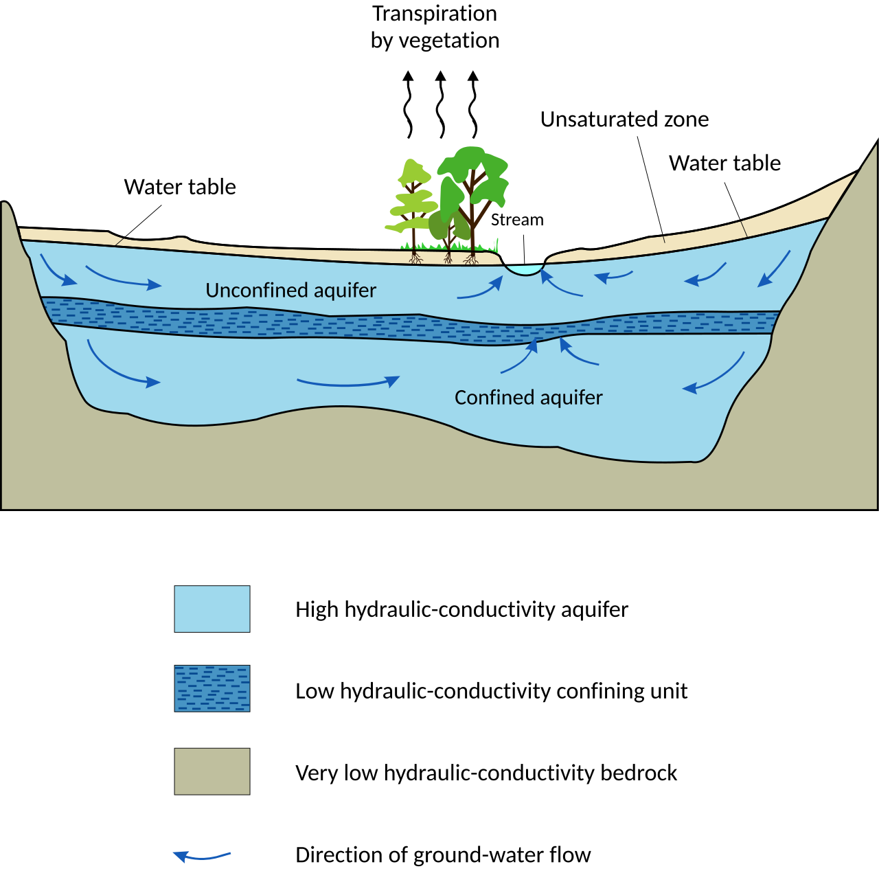
An aquifer is a body of rock or sediment sufficiently porous and permeable to store and transmit economically significant quantities of water to wells and springs. The term derives from the Latin aqua (water) and ferre (to carry), and the concept is central to all aspects of groundwater science. Not all geological materials function as aquifers: clays and unfractured crystalline rocks, though they may contain water in their pore spaces, transmit it so slowly that they are classified as aquitards or aquicludes, serving instead as confining layers that constrain groundwater flow within adjacent aquifers.1, 2
Porosity, permeability, and Darcy’s law
The capacity of a geological material to store and transmit groundwater is governed by two fundamental physical properties: porosity and permeability. Porosity is the fraction of the total volume of rock or sediment that consists of void space — the gaps between grains in an unconsolidated sand, the fractures in a crystalline rock, or the solution cavities in a limestone. It is expressed as a dimensionless ratio or percentage. Well-sorted gravel and sand typically have porosities of 25 to 50 percent, sandstones 5 to 30 percent, and unfractured crystalline rocks less than 5 percent, though fractured and weathered crystalline rocks may have substantially higher effective porosities.1, 15
Permeability describes the ease with which fluid flows through connected pore spaces under a hydraulic gradient. A material may have high porosity but low permeability if the pores are small and poorly connected, as in clay, which can have a porosity exceeding 50 percent but permeability so low that water moves through it at rates of millimetres per year. Conversely, a well-connected fracture network in otherwise low-porosity rock can produce high permeability. Hydraulic conductivity, the practical measure of permeability used in hydrogeology, spans more than twelve orders of magnitude in natural materials — from less than 10−12 metres per second in intact shale to more than 10−1 metres per second in clean gravel.1, 2
The quantitative foundation of groundwater flow was established by Henry Darcy in 1856, based on his experiments on water flow through sand filters for the public fountains of Dijon, France. Darcy’s law states that the volumetric flow rate of water through a porous medium is proportional to the hydraulic gradient (the change in hydraulic head per unit distance) and to the cross-sectional area of flow, with the constant of proportionality being the hydraulic conductivity of the medium.5 This deceptively simple relationship — Q = −KA(dh/dl), where Q is discharge, K is hydraulic conductivity, A is cross-sectional area, and dh/dl is the hydraulic gradient — remains the governing equation for virtually all calculations in groundwater hydrology, from the design of water-supply wells to the modelling of contaminant transport through aquifers.1, 2
Unconfined and confined aquifers
Aquifers are classified into two principal types based on the boundary conditions that control their hydraulic behaviour. An unconfined aquifer, also called a water-table aquifer, is one in which the upper boundary of the saturated zone — the water table — is free to rise and fall in response to recharge and discharge. Above the water table, pore spaces are partially filled with air (the vadose zone or zone of aeration); below it, all pore spaces are fully saturated. The water table is not a fixed surface but fluctuates seasonally and in response to pumping, rainfall, and changes in land use. In an unconfined aquifer, the water in a well rises only to the level of the water table, because the aquifer is open to atmospheric pressure at its upper surface.1, 2
A confined aquifer, by contrast, is bounded above and below by aquitards or aquicludes — layers of low-permeability material such as clay or unfractured shale — that prevent the aquifer from communicating directly with the surface. Water in a confined aquifer is under pressure greater than atmospheric, compressed by the weight of the overlying rock and water column. When a well is drilled into a confined aquifer, the water rises above the top of the aquifer to a level called the potentiometric surface (or piezometric surface), which represents the hydraulic head at that point. If the potentiometric surface lies above the ground elevation, the well is artesian — water flows freely to the surface under its own pressure without pumping.1, 2
The distinction between confined and unconfined conditions has important practical consequences. Unconfined aquifers are recharged directly by precipitation infiltrating through the soil and are therefore more vulnerable to surface contamination but also more readily replenished. Confined aquifers may receive recharge only at their outcrop areas, which can be hundreds of kilometres from the point of extraction, and the water they contain may have been in the subsurface for thousands to millions of years — so-called fossil groundwater that is effectively non-renewable on human timescales.2, 14
Major aquifer systems of the world
The world’s largest aquifer systems underlie vast areas of continental crust, and their geology, recharge rates, and exploitation histories illustrate the diversity of groundwater environments and the challenges of sustainable management. The Ogallala Aquifer (more formally, the High Plains Aquifer) underlies approximately 450,000 square kilometres of the Great Plains of the United States, spanning eight states from South Dakota to Texas. The aquifer consists primarily of Miocene and Pliocene alluvial sediments — sand, gravel, silt, and clay deposited by streams flowing eastward from the Rocky Mountains — with saturated thickness ranging from less than a metre in depleted areas to more than 300 metres in parts of Nebraska.3 The Ogallala supplies approximately 30 percent of all groundwater used for irrigation in the United States and supports an agricultural economy valued at tens of billions of dollars annually. However, recharge rates in the southern portion of the aquifer (the Texas Panhandle and western Kansas) are extremely low — only a few millimetres per year — because the region receives little precipitation and the soil and underlying caliche layers inhibit infiltration. Water levels in these areas have declined by more than 30 metres since large-scale irrigation began in the 1950s, and some wells have gone dry entirely.3, 4
The Great Artesian Basin of Australia is the largest and deepest artesian aquifer system in the world, extending over approximately 1.7 million square kilometres beneath arid and semi-arid eastern Australia. The main aquifer horizons are Jurassic and Cretaceous sandstones confined between impermeable marine mudstones, reaching depths of more than 3,000 metres at the basin centre. Recharge occurs along the elevated eastern margin where the aquifer sandstones crop out, and water flows slowly westward and southward over distances of up to 2,000 kilometres at rates of one to five metres per year, with residence times exceeding one million years in the deepest parts of the basin. The artesian pressure that characterised the basin when it was first tapped in the 1880s has declined significantly in many areas due to uncontrolled flowing bores, prompting the Australian government to cap and pipe thousands of bores to reduce wastage.11
The Nubian Sandstone Aquifer System, shared by Libya, Egypt, Chad, and Sudan, is one of the largest fossil groundwater reserves on Earth, containing an estimated 150,000 cubic kilometres of water accumulated during wetter Pleistocene climatic periods. Under present arid conditions, natural recharge is negligible, and the water being extracted — most notably by Libya’s Great Man-Made River project, which pipes groundwater from southern Saharan wellfields to the Mediterranean coast — is essentially non-renewable.14, 8 Karst aquifers represent a distinct category in which groundwater storage and flow are dominated by dissolution-enlarged conduits, fractures, and cavities in soluble rock, principally limestone and dolomite. Unlike porous-media aquifers where flow is slow and diffuse, karst aquifers can transmit water at velocities of metres to kilometres per day through cave passages and solution channels, making them both highly productive and extremely vulnerable to rapid contamination.6
The water table and groundwater flow
The water table is the surface within the subsurface at which the pore water pressure equals atmospheric pressure. Below this surface, all pore spaces are saturated; above it, in the vadose zone, pores contain both water and air. The water table is not flat but mimics a subdued version of the surface topography, standing higher beneath hills and lower beneath valleys. This configuration generates hydraulic gradients that drive groundwater flow from topographic highs toward topographic lows, where it discharges into streams, lakes, wetlands, and springs.1, 2
The relationship between groundwater and surface water is intimate and bidirectional. In humid regions, the water table typically lies above the elevation of stream channels for much of the year, and groundwater discharges into rivers as baseflow — the steady, sustained flow that keeps rivers running between storms. During dry periods, baseflow may constitute 90 percent or more of total streamflow. In arid regions, the reverse often occurs: the water table lies below the streambed, and the stream loses water to the subsurface, a condition known as a losing stream.2 The water table fluctuates in response to recharge from precipitation, discharge through pumping or natural seepage, and changes in evapotranspiration. In temperate climates, it is typically highest in spring when snowmelt and precipitation recharge the aquifer, and lowest in late summer when evapotranspiration is at its peak and irrigation demand is greatest.1
Groundwater flow rates are, in most geological settings, extremely slow compared with surface water. Typical velocities in porous aquifers range from centimetres to metres per day, though rates of only millimetres per year occur in fine-grained materials. This slowness has two consequences. First, it means that contaminants introduced into an aquifer may persist for decades or centuries, migrating slowly through the subsurface in plumes that can be difficult to detect and nearly impossible to remediate completely. Second, it means that the water stored in deep aquifers may have entered the subsurface thousands or millions of years ago, travelling the intervening distance at geological pace.2, 1
Groundwater depletion and its consequences
Global groundwater depletion — the sustained extraction of water from aquifers at rates exceeding natural recharge — has accelerated dramatically since the mid-twentieth century with the spread of mechanised pumping and the expansion of irrigated agriculture. Satellite gravimetry data from NASA’s GRACE mission, which measures month-to-month changes in Earth’s gravitational field caused by redistribution of water mass, have enabled the first comprehensive global assessment of groundwater storage trends. The results confirm what regional studies had long suggested: the world’s most productive agricultural aquifers are being drawn down at alarming rates.13, 4
Wada and colleagues estimated in 2010 that global groundwater depletion had reached approximately 154 cubic kilometres per year, with the largest contributions from India (approximately 68 km³/year), the United States (approximately 30 km³/year), Pakistan, China, Iran, and Mexico.4 GRACE data have confirmed dramatic losses in northwestern India, where groundwater levels have dropped by more than a metre per year across an area supporting 114 million people, driven by the irrigation of rice and wheat on the Indo-Gangetic Plain.16 In the United States, the Ogallala Aquifer has lost approximately 330 cubic kilometres of storage since predevelopment, with the most severe declines in the Texas Panhandle and southwestern Kansas, where the saturated thickness has decreased by more than half.3
The consequences of depletion extend well beyond the water supply itself. When water is removed from the pore spaces of compressible sediments, the overburden causes irreversible compaction of the aquifer material, leading to permanent land subsidence at the surface. Mexico City, built on the compressible clays of a former lakebed, has subsided by more than nine metres since the early twentieth century due to groundwater pumping, and parts of California’s San Joaquin Valley have subsided by nearly nine metres for the same reason.9 In coastal areas, excessive groundwater extraction lowers the freshwater head, allowing denser saltwater from the ocean to migrate inland through the aquifer — a process known as saltwater intrusion. Once an aquifer is contaminated with salt, remediation is difficult and slow, effectively rendering the resource unusable for drinking or irrigation without costly desalination.10
The depletion of fossil groundwater raises especially stark questions of intergenerational equity. The water being pumped from the Ogallala, the Nubian Sandstone, and similar systems accumulated over timescales of thousands to millions of years under climatic conditions very different from those that exist today. Under current arid or semi-arid conditions, natural recharge is negligible relative to extraction rates, and the resource is being consumed as if it were a nonrenewable mineral deposit. The geological processes that recharged these aquifers — wetter Pleistocene climates, glacial meltwater, different drainage patterns — cannot be replicated by human intervention, meaning that the water, once gone, is gone for good on any timescale meaningful to human civilisation.4, 7, 14