Overview
- Cahokia was the largest pre-Columbian settlement north of Mexico, located in the American Bottom floodplain near present-day St. Louis, with a peak population estimated at 10,000–20,000 people around 1050–1200 CE and more than 120 earthen mounds including Monks Mound, the largest earthwork in the Americas.
- The city emerged with extraordinary rapidity during the Lohmann phase (c. 1050–1100 CE) through a combination of immigration and political consolidation, developing monumental architecture, solar observatories, a defensive palisade, and long-distance exchange networks that extended across the midcontinent.
- Cahokia declined during the thirteenth and fourteenth centuries through a convergence of climatic instability, prolonged drought, flooding, soil depletion, and increasing social stress, and was largely abandoned by 1400 CE, becoming part of the archaeological 'Vacant Quarter' of the central Mississippi valley.
Cahokia was the largest pre-Columbian settlement north of Mexico, a sprawling urban centre of earthen mounds, plazas, and residential neighbourhoods situated in the American Bottom floodplain of the Mississippi River, approximately eight kilometres east of present-day St. Louis, Missouri. At its zenith between roughly 1050 and 1200 CE, Cahokia's population is estimated to have reached 10,000 to 20,000 people, making it comparable in size to contemporary medieval European cities such as London.1, 2 The site encompassed more than 120 earthen mounds arranged across approximately 16 square kilometres, centred on Monks Mound—the largest earthwork in the Americas—and a massive Grand Plaza that served as the civic and ceremonial heart of the community.1, 10 Designated a UNESCO World Heritage Site in 1982, Cahokia represents the most dramatic expression of the Mississippian culture that flourished across the southeastern and midcontinental United States from approximately 800 to 1600 CE, and its rapid emergence and eventual abandonment remain among the most intensively studied episodes in North American archaeology.10, 15
Emergence and rapid growth
The transformation of Cahokia from a modest Late Woodland village into a major urban centre occurred with remarkable speed during the Lohmann phase (c. 1050–1100 CE). Within a few decades, the population surged from an estimated 1,400–2,800 inhabitants to between 10,200 and 15,300, a demographic explosion that Timothy Pauketat has characterised as a politically orchestrated "big bang" rather than a gradual process of organic growth.1, 2 Strontium isotope analysis of dental enamel from Cahokia burials has confirmed that a substantial proportion of this population growth resulted from immigration, with individuals arriving from diverse geological regions across the midcontinent, drawn by the emerging centre's political, economic, or ceremonial significance.9
The rapidity of Cahokia's emergence has prompted debate about the nature of its political organisation. Pauketat has argued that Cahokia transcended the conventional chiefdom model, exhibiting features more typical of early states, including urban planning, coordinated labour mobilisation, craft specialisation, and an ideological apparatus capable of integrating diverse immigrant populations into a shared political community.3, 1 Others maintain that Cahokia, despite its exceptional scale, operated within the range of variation seen in ranked chiefdom societies, where political authority was personalised, factional, and inherently unstable.17 Whatever the precise label, Cahokia's founding episode represents one of the most rapid instances of urban coalescence documented in the pre-industrial world, comparable in tempo, if not in scale, to the earliest urban centres of Mesopotamia and the Indus Valley.1, 3
Monks Mound and the monumental landscape
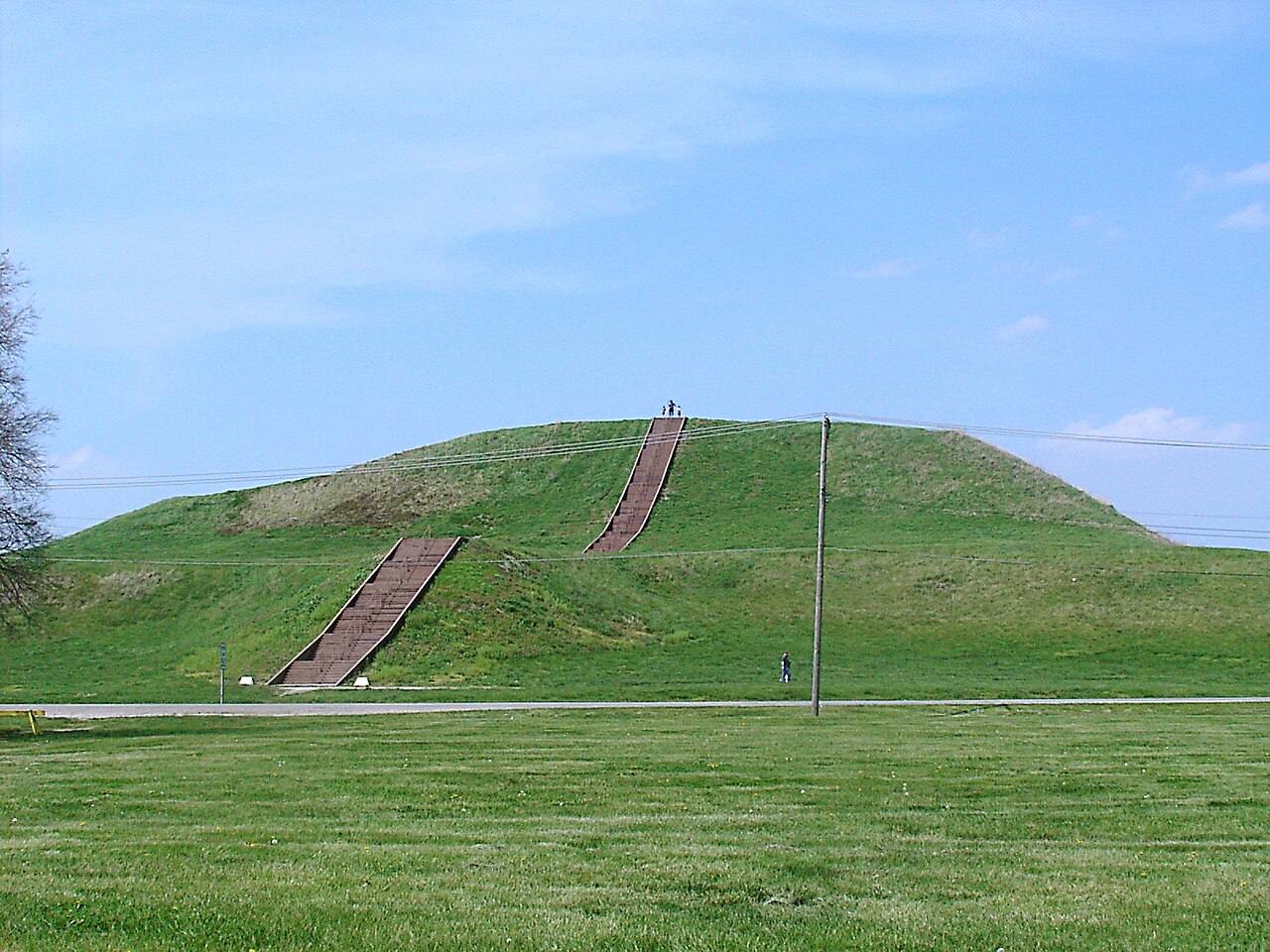
The centrepiece of Cahokia's built environment was Monks Mound, an enormous flat-topped earthwork that rises approximately 30 metres above the surrounding floodplain and covers more than 5.6 hectares at its base, making it the largest earthen construction anywhere in the Americas.4, 10 The mound was constructed in multiple stages using a combination of basket-loaded fill of mixed clays and sandy soils, stacked sod blocks, and scattered earth deposits. Bayesian chronological modelling of radiocarbon dates by Timothy Schilling indicates that the bulk of Monks Mound was built in two rapid construction episodes between approximately 1050 and 1200 CE, far more quickly than the 250-year timeline proposed by earlier researchers.4, 5 The summit supported a large wooden structure, likely the residence or audience hall of Cahokia's paramount chief, positioned to command views of the Grand Plaza below—a levelled and partially filled open space of roughly 19 hectares that could accommodate thousands of people for ceremonies and public gatherings.1, 2
Beyond Monks Mound, Cahokia's landscape included more than 120 additional mounds of varying size and function—platform mounds for elite residences and temples, conical mounds for burials, and ridge-top mounds whose purpose remains less clear.1, 15 The site also featured a series of large circular arrangements of wooden posts, dubbed "Woodhenge" by archaeologist Warren Wittry, which functioned as solar observatories for marking the solstices and equinoxes, analogous in principle if not in material to Stonehenge.16, 2 A defensive wooden palisade with regularly spaced bastions enclosed approximately 120 hectares of the central precinct, rebuilt at least four times during the site's occupation, indicating both the scale of organised labour available to Cahokian elites and mounting concerns about security and warfare in the later phases of the city's history.12, 13
Mound 72 and social hierarchy
The most direct archaeological evidence for the extremes of social stratification at Cahokia comes from Mound 72, a small ridge-top mound located south of Monks Mound. Excavations in the 1960s and 1970s uncovered a series of elaborate burials that vividly illustrate the concentration of power and ritual authority at the apex of Cahokian society.8, 11 The central burial, traditionally interpreted as a paramount chief, was interred on a platform of more than 20,000 marine shell disc beads, accompanied by caches of finely crafted projectile points, mica sheets, and copper ornaments. Surrounding this central feature were mass graves containing at least 272 individuals, many of them young adults who appear to have been sacrificed as part of the funerary rituals.11, 8
Recent reanalysis by Thomas Emerson and colleagues has revised earlier interpretations of the Mound 72 burials. The central burial, long described as a single high-status male, was found upon re-examination to consist of two individuals—one male and one female—interred together on the shell bead platform, suggesting that the mortuary programme reflected complementary gender roles in Cahokian leadership rather than the authority of a single male ruler.11 Dental morphology and strontium isotope analysis of the sacrificial victims indicate that most were local to the Cahokia region rather than foreign captives, challenging earlier assumptions about the origins of those killed in the rituals.8 Together, these findings underscore both the pronounced social inequality and the ritual complexity that characterised Cahokia at its peak.
Economy and exchange
Cahokia's economic foundation rested on the intensive cultivation of maize, supplemented by beans, squash, and the continued use of native seed crops such as chenopodium and sunflower. The fertile alluvial soils of the American Bottom floodplain, naturally renewed by seasonal flooding, provided exceptionally productive agricultural land capable of generating the caloric surpluses necessary to support a dense, non-farming population of craft specialists, builders, and ritual practitioners.1, 17 Long-distance exchange networks connected Cahokia to sources of exotic prestige materials across the midcontinent: marine shell from the Gulf Coast, copper from the Great Lakes, galena from the upper Mississippi valley, chert from specialised quarries, and mica from the Appalachian region.12, 17
These materials were transformed by craft specialists into the ritual objects and status markers that sustained chiefly authority within the Southeastern Ceremonial Complex, the shared iconographic system linking Mississippian polities across the Southeast.12, 1 Cahokia's position at the confluence of the Mississippi, Missouri, and Illinois rivers gave it unparalleled access to the continent's major riverine transportation corridors, and strontium isotope data confirming the diverse geographic origins of Cahokia's population suggest that the city functioned as a hub attracting people, goods, and ideas from a vast catchment area.9, 2
Decline and abandonment
Cahokia began to contract during the Moorehead phase (c. 1200–1350 CE), when the population declined from its Stirling-phase peak and the monumental palisade was erected around the central precinct, suggesting increased social stress and security concerns.13, 12 By approximately 1400 CE, Cahokia and the surrounding American Bottom had been largely abandoned, and the region became part of what archaeologists term the "Vacant Quarter"—a broad zone of depopulation extending across the confluence region of the Ohio and Mississippi rivers.14
Paleoenvironmental research has increasingly implicated climatic instability as a major contributing factor. Analysis of fecal stanols preserved in Horseshoe Lake sediments near Cahokia documented simultaneous flooding events and seasonal precipitation changes that correlated with periods of population decline during the thirteenth century.7 A subsequent study of oxygen isotope ratios in the same sediment core identified a severe and prolonged drought between approximately 1250 and 1400 CE, coinciding with the onset of the Little Ice Age, that would have devastated maize yields in the American Bottom.6 These environmental pressures, compounded by soil depletion from centuries of intensive maize cultivation and the political fragility inherent in chiefdom-level governance, likely undermined the agricultural surpluses on which Cahokia's power structure depended.6, 7, 13
The abandonment of Cahokia did not represent the disappearance of its people. Descendant communities dispersed across the midcontinent, and the oral traditions, cosmological beliefs, and material culture of the historically documented Native American nations of the region—including the Osage, Quapaw, and other Dhegihan Siouan-speaking peoples—preserve recognisable continuities with their Mississippian antecedents.15, 1 Cahokia's UNESCO World Heritage designation and ongoing archaeological research ensure that the site continues to illuminate one of the most remarkable chapters in the history of North American complex societies, demonstrating that large-scale urbanism, monumental architecture, and hierarchical political organisation emerged independently in the temperate woodlands of eastern North America.10, 15
References
Severe Little Ice Age Drought in the Midcontinental United States during the Mississippian Abandonment of Cahokia
Fecal Stanols Show Simultaneous Flooding and Seasonal Precipitation Change Correlate with Cahokia’s Population Decline
New Dental and Isotope Evidence of Biological Distance and Place of Origin for Mass Burial Groups at Cahokia’s Mound 72
Immigrants at the Mississippian Polity of Cahokia: Strontium Isotope Evidence for Population Movement
The Vacant Quarter Revisited: Late Mississippian Abandonment of the Lower Ohio Valley