Overview
- Prehistoric humans crossed open ocean far earlier than once believed — the colonization of Sahul (Australia and New Guinea) at least 65,000 years ago required multiple sea crossings through the Wallacea island chain, implying deliberate navigation long before agriculture or metallurgy.
- The Austronesian expansion, beginning in Taiwan around 5,000 years ago and spreading across an area spanning nearly half the globe, is the largest migration by geographic extent in human prehistory, reaching as far as Hawai‘i, New Zealand, Easter Island, and — in the opposite direction — Madagascar.
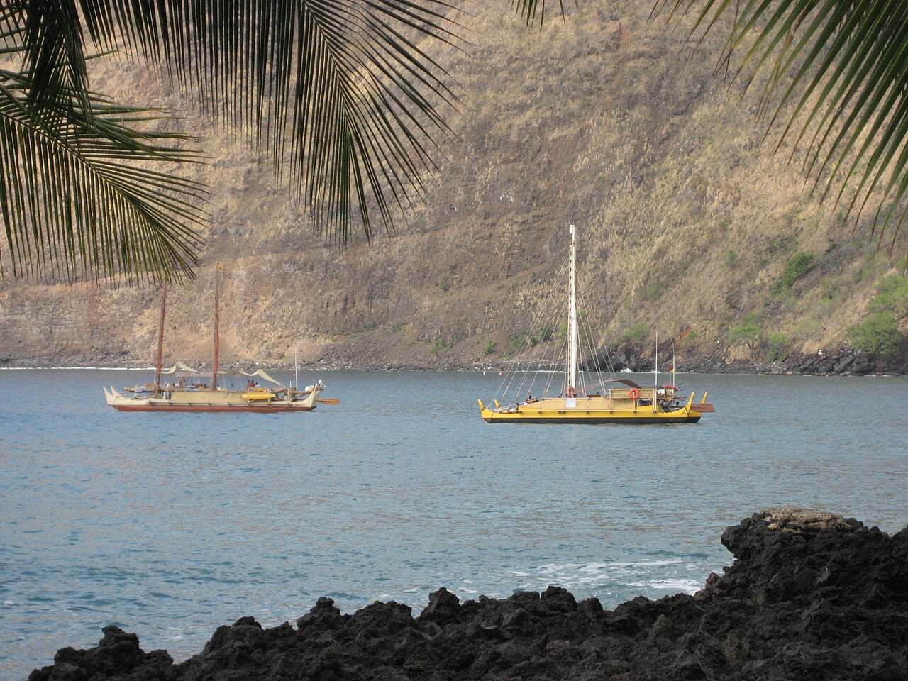
- Polynesian navigators crossed the Pacific without instruments, using star compasses, wave-piloting, cloud patterns, and bird behavior to locate islands hundreds of kilometers away; this knowledge, nearly lost in the twentieth century, was revived by the voyages of the Hōkūle‘a and the work of the Polynesian Voyaging Society.
Of all the chapters in human prehistory, few are as astonishing as the repeated conquest of open ocean by people who had neither compass nor chart nor written instruction. From the first crossings into Sahul more than 65,000 years ago to the Norse landfall in North America around 1,000 ce, seafaring peoples pushed into empty horizons carrying only accumulated knowledge of wind, star, wave, and bird. The story is not one of accident but of systematic exploration: populations that expanded their range across water gaps, developed increasingly sophisticated navigational traditions, and left genetic, linguistic, and material signatures that modern science is only now fully deciphering.
The dispersal of anatomically modern humans out of Africa was itself partly a maritime story. The coastal corridor hypothesis proposes that early modern humans followed shorelines and exploited marine resources as they pushed eastward through South Asia and into island Southeast Asia, skills that would eventually enable the decisive leap across the deep-water straits that separated the continental shelf of Sunda from the landmass of Sahul.3 The archaeology of island colonization thus illuminates not merely geography but cognition: the capacity for systematic planning, inter-generational transmission of knowledge, and collective risk-taking that defines our species.
Sahul and the Wallacea crossings
The first unambiguous evidence of open-ocean seafaring comes from the colonization of Sahul — the Pleistocene landmass that united present-day Australia, New Guinea, and Tasmania when sea levels were lower than today. Even at the glacial maximum, reaching Sahul from Sunda (the Southeast Asian continental shelf) required crossing at least 90 kilometers of open water through the Wallacea region, the chain of islands lying between the Asian and Australian biogeographic zones.2 There was no land bridge; the crossings were made by sea, and the minimum number of required open-water legs has been estimated at four, with the longest single stretch exceeding 70 kilometers — well beyond the horizon, requiring intentional navigation rather than accidental drift.
The dating of the initial colonization has been revised substantially upward in recent decades. Excavations at the Madjedbebe rock shelter in the Northern Territory of Australia, published in 2017, yielded a robust series of optically stimulated luminescence (OSL) dates placing the earliest occupation at approximately 65,000 years ago, predating any earlier estimates by some 18,000 years.1 The assemblage includes ground-edge hatchets, ground ochre, and reflective materials, implying a behaviorally complex founding population. The implication is stark: by at least 65,000 years before the present, humans possessed watercraft capable of repeated, deliberate open-water crossings, and the social organisation to mount colonizing voyages that were unlikely to succeed on a single attempt. This places seafaring technology firmly in the Middle Stone Age, contemporaneous with the period of Denisovan presence in the region — and genomic data confirm that the ancestors of Aboriginal Australians and Papuans carry a significant fraction of Denisovan ancestry, most likely acquired in the islands of Wallacea itself.3
The Lapita complex and the Austronesian expansion
After the initial peopling of Sahul, the western Pacific saw relatively limited inter-island movement for tens of thousands of years. The transformative second wave came with the Austronesian expansion, one of the most consequential demographic events in human prehistory. Linguistic and genetic evidence converge on Taiwan as the homeland of the Proto-Austronesian language family, with the migration beginning around 5,000 years ago.4, 5 From Taiwan, Austronesian-speaking populations spread southward into the Philippines, then westward into Island Southeast Asia, and eastward through Island Melanesia at a pace that, by archaeological standards, was extraordinarily rapid. By approximately 3,500 years ago, they had reached the islands of Remote Oceania, a domain of small, widely scattered islands for which there was no prior indigenous population and no model of successful long-range navigation to emulate.
The archaeological signature of this eastward pulse is the Lapita cultural complex, first identified by its distinctive dentate-stamped pottery. Lapita ceramics appear in the Bismarck Archipelago around 3,500 – 3,200 years ago and spread rapidly through Vanuatu, New Caledonia, Fiji, Tonga, and Samoa over a period of perhaps three to five centuries.6, 7 The pottery is not merely decorative: its geometric motifs carry cultural information across vast stretches of water, and the consistency of design across thousands of kilometers of ocean implies sustained contact between island communities rather than isolated founder populations. Lapita sites also yield obsidian from specific volcanic sources in the Bismarck Archipelago, demonstrating long-distance trade networks — and the capacity to reliably navigate back and forth between known points — from the earliest phase of Remote Oceanic settlement.7
Lapita peoples brought with them a transported landscape of domesticated plants and animals: taro, breadfruit, yam, banana, pig, chicken, dog, and the Pacific rat (Rattus exulans), a package that made colonization of resource-poor oceanic islands viable.9 They settled the islands of Fiji around 3,200 years ago and rapidly moved into western Polynesia, reaching Tonga and Samoa by approximately 2,800 years ago.8 These western Polynesian islands became a long-term laboratory: for roughly a thousand years, the founding Polynesian population consolidated its culture, language, and navigational knowledge before launching the extraordinary eastward push into Remote Oceania that would eventually populate every habitable island in the Pacific.
The settlement of Remote Oceania
After the western Polynesian pause, the colonization of Remote Oceania proceeded in a series of rapid pulses. High-precision radiocarbon dating of short-lived materials, particularly seeds and uncharred plant remains rather than the long-lived charcoal that had complicated earlier chronologies, has substantially revised and tightened the settlement dates for most island groups.18 The Society Islands and Cook Islands were reached by approximately 1,000 – 900 years ago; the Hawaiian archipelago, the most isolated island group in the world, was colonized around 1,000 years ago; Easter Island (Rapa Nui), nearly 3,700 kilometers from the nearest continental coast, was settled around 800 years ago; and New Zealand — the last major landmass to receive a human population — was colonized by East Polynesian voyagers approximately 700 – 750 years ago, making it one of the most recent in the entire human expansion out of Africa.18, 11
The settlement chronology carries a profound implication: these were not accidental arrivals. Hawai‘i lies 3,800 kilometers from the Marquesas, the most likely origin point. Easter Island is some 3,700 kilometers from the Pitcairn group. New Zealand is more than 2,500 kilometers south of the Tonga – Samoa region. That populations reached these destinations at all — and that genetic and linguistic evidence shows clear connections to specific source regions — demonstrates systematic, repeatable navigation. Canoe voyages were not one-way events; return voyages are evidenced by the consistent genetic links between island groups and by the presence of Polynesian commensal animals and cultivars that can only have been transported intentionally.15, 17
The question of Polynesian contact with the Americas was long debated. Thor Heyerdahl’s 1947 Kon-Tiki expedition, sailing westward from Peru on a balsa raft, argued for South American origins of Polynesian settlement, but the overwhelming weight of linguistic, genetic, and archaeological evidence places the migration direction firmly from west to east. Nevertheless, there is now strong evidence for pre-Columbian contact between Polynesia and South America in the opposite direction: the sweet potato (Ipomoea batatas), a South American domesticate, was present across Polynesia before European contact, most plausibly carried back by Polynesian voyagers who reached the South American coast and returned.19 Genomic studies have also identified a clear signal of Native American ancestry in some eastern Polynesian populations, consistent with a single contact event in the eastern Pacific around 1,200 years ago.
Polynesian navigation: the science of wayfinding
The navigational system that made the Polynesian expansion possible was a sophisticated body of knowledge transmitted orally across generations, encompassing astronomy, oceanography, meteorology, and biology. At its core was the star compass — a mental construct dividing the horizon into named sectors corresponding to the rising and setting points of specific stars. A navigator using the star compass did not merely track a single star but held a mental model of the entire night sky, using stars near the horizon as directional indicators when high stars gave only approximate bearings. Memorized star paths for specific inter-island routes, known in Hawaiian tradition as kilo hōkū (star watching), encoded accumulated voyaging experience in a form transmissible without instruments.20
Complementing the star compass was an equally sophisticated system of ocean-swell reading. The deep ocean carries persistent swell trains generated by distant storm systems in predictable directions; in the Pacific, the northeast and southeast trade wind swells, the North Pacific swell, and reflected swells from islands and atolls all provide directional information that a trained navigator could sense through the motion of the hull. Polynesian navigators learned to identify the characteristic interference patterns created when swells refract around islands, which can be detectable as far as 50 – 100 kilometers from the island itself, extending the effective detection range far beyond visual range. Cloud behavior over land, phosphorescent sea lanes, and the presence of land-based bird species — particularly noddies and boobies, which rarely venture more than 50 kilometers from shore — provided the final confirmation of an island’s presence.
By the twentieth century, much of this knowledge had been lost or severely attenuated across Polynesia, suppressed by colonialism and the disruption of indigenous maritime culture. Its systematic revival is largely the work of the Polynesian Voyaging Society (PVS), founded in 1973, and its flagship vessel Hōkūle‘a, a double-hulled voyaging canoe (waka hourua) constructed on traditional lines. The pivotal figure in this revival was Mau Piailug, a Micronesian master navigator from Satawal who had retained traditional non-instrument wayfinding and agreed to guide the Hōkūle‘a on its first voyage from Hawai‘i to Tahiti in 1976. Nainoa Thompson, a Native Hawaiian who trained under Piailug, subsequently developed a teachable form of the star compass adapted to the Hawaiian context and has navigated the Hōkūle‘a on numerous subsequent voyages, including a round-the-world voyage from 2013 to 2017. The PVS voyages demonstrated empirically that traditional navigation was capable of reliable, intentional inter-island travel across thousands of kilometers of open ocean, settling definitively the question of whether Polynesian settlement could have been achieved by accident.20
Genetic evidence for Pacific migrations
Molecular genetics has provided some of the most powerful confirmation of the archaeological and linguistic models for Pacific settlement. Mitochondrial DNA (mtDNA) studies of Polynesian populations identified a distinctive cluster of haplotypes — the so-called “Polynesian motif” — defined by a specific combination of mutations in the hypervariable region of the mitochondrial control region.10 This motif is found at near-fixation in most Polynesian populations, traces to an East Asian or Taiwanese source population consistent with the Austronesian expansion model, and reached high frequency through a combination of founder effect and genetic drift during the small-population colonization bottlenecks that accompanied each successive island settlement. Y-chromosome studies similarly identify a Polynesian-specific haplogroup (C-M208) that carries the signal of the Austronesian expansion across the Pacific.16
Whole-genome analyses have refined the picture considerably. The genomic history of Pacific populations reveals a layered ancestry: Polynesian genomes carry a predominant Austronesian (East Asian-related) component derived from the Taiwan homeland population, mixed with a Papuan component acquired during the passage through Near Oceania, where Austronesian migrants interacted with the long-established descendant populations of the original Sahul colonizers.3 The ratio of these components varies systematically: western Polynesian populations (Tonga, Samoa) carry somewhat more Papuan ancestry than eastern Polynesian populations (Hawai‘i, New Zealand, Easter Island), consistent with the model of a western Polynesian founding population that subsequently experienced additional Papuan admixture before or during the Remote Oceanic expansion. Ancient DNA from archaeological specimens in New Zealand has confirmed the East Polynesian origins of the Māori founding population and is consistent with a founding event within the last 750 years.11
Madagascar: the Indian Ocean crossing
Perhaps the most geographically extraordinary of all prehistoric seafaring achievements is the colonization of Madagascar. The island lies approximately 400 kilometers off the coast of East Africa, but its indigenous population is overwhelmingly of Austronesian origin: the Malagasy language belongs unambiguously to the Austronesian family, specifically to a subgroup closely related to the languages of the Barito region of southern Borneo, some 6,000 kilometers to the east across the Indian Ocean.12 Archaeological and genetic dating suggests the Austronesian settlement of Madagascar occurred around 1,500 – 1,200 years ago, though some linguistic arguments push the contact earlier.
The route taken by the founding Austronesian population remains debated. One model proposes a direct crossing from Borneo or the Malay Peninsula westward along the trade wind belt; another suggests a stepwise movement along the Indian Ocean coastline via South Asia, the Arabian Peninsula, and East Africa before the final crossing to Madagascar. Genetic studies of modern Malagasy populations confirm a dual ancestry: a dominant Austronesian component closely related to Borneo populations and a substantial Bantu African component, likely acquired through contact with East African populations either during the Indian Ocean crossing or after initial settlement.13 The genomic data suggest these two founding streams mixed relatively early in Malagasy prehistory, producing the distinctive population visible today. Whatever the route, the achievement stands: Austronesian seafarers reached Madagascar from Southeast Asia, crossing or skirting the Indian Ocean, at a time when the ocean was thought by many Western historians to be essentially uncrossable without later navigational technologies.
Norse Atlantic expansion
In the North Atlantic, a separate tradition of maritime expansion produced another series of remarkable colonizations. Norse seafarers, operating from Scandinavia and using the clinker-built longship, began probing the North Atlantic in the eighth century ce. The settlement of Iceland around 870 ce was followed by the colonization of Greenland around 985 ce under Erik the Red, and by the end of the first millennium, Norse voyagers under Leif Eriksson had reached the coast of North America — the site known as L’Anse aux Meadows in Newfoundland, the only confirmed Norse site in the Americas, dating to around 1,000 ce. The Norse Atlantic voyages were navigated using solar and stellar references, including the use of a “sun stone” (solarsteinn) that may have been a form of calcite crystal capable of determining solar azimuth under overcast conditions.
Genomic studies of ancient Icelanders have confirmed the genetic structure of the Norse founding population: predominantly Scandinavian in paternal lineage, with a substantial Scottish and Irish maternal component consistent with the historical accounts of Norse raiding and settlement in the British Isles before the Icelandic colonization.14 The Norse North Atlantic expansion was ultimately limited by the climate deterioration of the Little Ice Age and the failure to establish enduring contact with indigenous North American populations, but it stands as a distinct and independently developed tradition of systematic open-ocean navigation.
Convergences and broader significance
Taken together, the prehistoric seafaring record reveals several convergent features across unrelated traditions. All successful colonizing populations invested in watercraft technology well beyond what inshore fishing required; all developed systematic knowledge of celestial, oceanic, and biological cues that extended effective navigational range; and all practiced what can reasonably be called exploratory strategy, sending out multiple voyages to unknown destinations until viable landfalls were confirmed. The Polynesian expansion in particular shows clear evidence of systematic search: the pattern of island discovery, with larger and closer islands found before more distant and smaller ones, is consistent with a strategy of sailing to the wind and returning downwind, maximizing the probability of finding land while preserving the ability to return home with information.20
The genomic revolution has transformed understanding of these migrations in ways complementary to archaeology. Ancient DNA from Pacific skeletal material, combined with modern population genomics, now provides a population-level picture of who settled which islands in what order, with what admixture from prior or contemporary populations, and with what subsequent demographic history. The picture that emerges for the Austronesian expansion is of a demographically aggressive, technologically sophisticated set of peoples who, over roughly 5,000 years, colonized a domain stretching from Madagascar in the west to Easter Island in the east — more than half the circumference of the Earth — leaving linguistic, genetic, and material descendants on every island in that vast oceanic space. The ancient DNA and population history of the Pacific is one of the most active research frontiers in contemporary paleoanthropology, and each new genomic dataset refines the already remarkable story of what human beings, with open ocean before them and the stars above, were willing and able to do.
References
The Wallacea region as a major evolutionary hotspot for Southeast Asian freshwater fishes and the role of ancient geography and climate change
The Norse Atlantic saga revisited: genetic connections between Norse Iceland and Greenland
Thor Heyerdahl’s Kon-Tiki hypothesis and the genetic ancestry of sweet potato in Polynesia