Overview
- The Alps formed from the closure of the Tethys Ocean and the subsequent collision between the African and European plates beginning in the Late Cretaceous, producing a complex fold-and-thrust belt that preserves a complete record of ocean opening, subduction, and continental collision spanning more than 200 million years.
- The Alpine orogen is divided into three principal tectonic zones — the Helvetic, Penninic, and Austroalpine nappes — each representing a different palaeogeographic domain: the European margin, the Tethyan oceanic basin and its margins, and the Adriatic (African) microplate, respectively, stacked atop one another by successive phases of thrusting.
- The Alps have been profoundly reshaped by Quaternary glaciation, which carved the characteristic U-shaped valleys, cirques, arêtes, and horn peaks that define the modern landscape, while seismic tomography reveals the subducted European slab extending to depths of 200–300 kilometres beneath the orogen, directly imaging the plate tectonic engine that built the range.
The Alps are the most prominent mountain range in Europe, stretching approximately 1,200 kilometres in a broad arc from the Ligurian coast of the Mediterranean Sea through Switzerland, Austria, and Bavaria to the Vienna Basin. They represent the product of a protracted tectonic history spanning more than 200 million years, beginning with the opening of the Tethys Ocean in the Triassic and Jurassic periods and culminating in the ongoing collision between the African and European plates that has been building the range since the Late Cretaceous.1, 11 The Alps are one of the most intensively studied mountain belts on Earth, and their geology has been foundational to the development of key concepts in structural geology, including the nappe theory of large-scale horizontal thrusting, the recognition of metamorphic facies, and the discovery of ultra-high-pressure metamorphism. The range also provides a superb natural laboratory for understanding the interplay between tectonics, erosion, and climate, with the dramatic glacial landscapes of the modern Alps recording the profound reshaping of a collision-built mountain belt by Quaternary ice sheets.9, 16
The Tethys Ocean and its closure
The geological story of the Alps begins with the opening of the Tethys Ocean, a now-vanished seaway that once separated the supercontinent Pangaea's northern landmass (Laurasia) from its southern counterpart (Gondwana). During the Late Triassic and Early Jurassic periods, approximately 220–180 million years ago, rifting between Africa (including the Adriatic microplate, which is a promontory of the African plate) and Europe produced a series of extensional basins that evolved into true oceanic crust by the Middle Jurassic, approximately 170–160 million years ago.7 The Tethys Ocean widened progressively through the Jurassic and into the Early Cretaceous, reaching a maximum width of perhaps 1,000–1,500 kilometres, floored by basaltic oceanic crust overlain by deep-marine sediments including radiolarites, pelagic limestones, and turbidites.7
The palaeogeographic reconstruction of the Alpine Tethys reveals a complex basin geometry rather than a simple, unitary ocean. The Piemonte-Liguria ocean, the principal Tethyan basin preserved in the Western Alps, was bounded on the north by the thinned European continental margin and on the south by a microcontinent or chain of continental fragments (the Briançonnais terrane) that separated it from a more southerly basin, the Valais trough, which lay between the Briançonnais and the main European margin.2, 3 This complex arrangement of basins and microcontinents means that the Alpine orogen records not a single, straightforward ocean closure but a sequence of subductions, collisions, and sutures involving multiple distinct palaeogeographic domains — a complexity that has made the Alps both a fascinating and a challenging object of geological study.
The closure of the Tethys Ocean began in the Late Cretaceous, approximately 85–90 million years ago, when convergence between Africa and Europe initiated southward-dipping subduction of the Piemonte-Liguria oceanic crust beneath the Adriatic microplate.11 The subduction consumed the oceanic lithosphere progressively, producing a volcanic arc and associated metamorphism as the oceanic crust descended to depths of 50–100 kilometres or more. Fragments of the subducted oceanic crust were not entirely consumed, however; some were scraped off the descending slab and incorporated into the growing orogenic wedge as ophiolites — tectonically emplaced slices of oceanic crust and upper mantle that now crop out as distinctive serpentinite, gabbro, and pillow basalt units throughout the Western Alps.6
Nappe structure and the three principal tectonic zones
The internal architecture of the Alps is dominated by nappes — large, sheet-like bodies of rock that have been detached from their original position and transported laterally by tens to hundreds of kilometres along low-angle thrust faults. The nappe concept was first developed in the late nineteenth and early twentieth centuries by Swiss geologists including Albert Heim, Émile Argand, and Maurice Lugeon, who recognised that the complex repetitions of stratigraphic units observed in Alpine cross-sections could only be explained by enormous horizontal displacements superimposed on the vertical uplift of mountain building.1
The Alpine nappes are organised into three principal tectonic zones, each representing a different palaeogeographic domain of the original Tethyan system.3
The Helvetic zone occupies the external (northwestern) margin of the Alps and consists of nappes derived from the European continental margin. These nappes comprise Mesozoic and Cenozoic sedimentary sequences — limestones, marls, and sandstones — that were deposited on the subsiding European shelf and subsequently detached and thrust northwestward over the European foreland during the main phases of Alpine compression. The Helvetic nappes display relatively low-grade metamorphism, reflecting their derivation from the shallow, external part of the orogen. Classic localities such as the Glarus thrust in eastern Switzerland, where older Verrucano red beds have been thrust over younger Flysch sediments along a remarkably planar fault surface, provided some of the earliest field evidence for the nappe concept.1, 3
The Penninic zone forms the structural core of the Alps and contains the most complex and most intensely deformed rocks. The Penninic nappes include both oceanic material (ophiolites from the Piemonte-Liguria and Valais basins) and continental material derived from the intervening microcontinents, including the Briançonnais terrane and the Monte Rosa nappe.2, 3 Many Penninic units record high-pressure to ultra-high-pressure metamorphism, having been subducted to depths exceeding 100 kilometres before being exhumed back to the surface — a process that defied geological expectation when first documented but is now recognised as a fundamental aspect of collisional orogens. The discovery of coesite (a high-pressure polymorph of quartz stable only above approximately 2.5 gigapascals) in Penninic rocks of the Western Alps by Christian Chopin in 1984 was a landmark finding that demonstrated continental crust had been subducted to mantle depths and subsequently returned to the surface.19
The Austroalpine zone occupies the internal (southeastern) side of the orogen and consists of nappes derived from the Adriatic (African) microplate. These include both crystalline basement rocks and their Mesozoic sedimentary cover, thrust northwestward over the Penninic units during the main collisional phase. The Austroalpine nappes dominate the Eastern Alps, forming the structural uppermost units of the nappe stack, and include the Northern Calcareous Alps — a spectacular belt of Triassic and Jurassic limestones and dolomites that includes some of the most dramatic mountain scenery in Austria and the Dolomites of northeastern Italy.1, 3
Ophiolites and the record of oceanic crust
The ophiolites of the Alps preserve fragments of the Tethyan oceanic crust and upper mantle that were emplaced into the orogenic wedge during the subduction and collision process rather than being entirely consumed in the mantle. These ophiolitic bodies provide direct evidence for the former existence of the Tethys Ocean and allow geologists to study the composition and structure of oceanic lithosphere that would otherwise have been lost to subduction.6
Alpine ophiolites are found principally within the Penninic zone, distributed along the suture that marks the former position of the Piemonte-Liguria oceanic basin. Classic localities include the Zermatt-Saas zone in the Swiss-Italian Western Alps, where pillow basalts, gabbros, and serpentinised mantle peridotites have been metamorphosed to eclogite facies (pressures exceeding 2 gigapascals) during their subduction and subsequent exhumation.12 The Chenaillet massif near Montgenèvre on the French-Italian border preserves a less-metamorphosed ophiolite section that retains recognisable pillow lavas and sheeted dykes, providing a clearer window into the original oceanic crustal architecture. The Ligurian ophiolites of the Northern Apennines, while tectonically part of the Apenninic rather than the Alpine belt proper, are genetically related to the same Tethyan oceanic lithosphere and have been instrumental in understanding the magmatic processes at Mesozoic mid-ocean ridges.6
The Alpine ophiolites differ in important respects from the archetypal Penrose-type ophiolite sequence (pillow basalts, sheeted dykes, gabbros, mantle peridotites in an orderly layer-cake succession). Many Alpine ophiolites lack a well-developed sheeted dyke complex and instead show mantle peridotites directly overlain by thin basaltic lavas and deep-marine sediments, a structure interpreted as evidence that the Piemonte-Liguria basin was a slow-spreading ocean, analogous to the modern Mid-Atlantic Ridge, where tectonic extension and faulting expose mantle rocks directly on the seafloor rather than building a thick, continuous magmatic crust.6
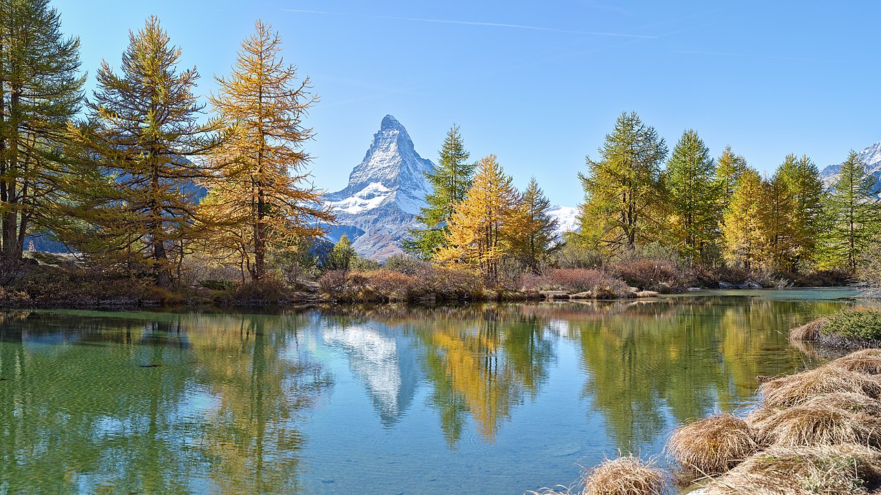
The Matterhorn and the geology of an iconic peak
The Matterhorn (4,478 metres), arguably the most recognisable mountain in the world, is a geological monument to the complexity of Alpine nappe tectonics. Its pyramidal form, shaped by glacial erosion into four steep faces and a pointed summit ridge, is composed of rocks derived from at least two distinct palaeogeographic domains separated by a major tectonic contact.8
The summit and upper faces of the Matterhorn are composed of Austroalpine gneisses — crystalline basement rocks of the Adriatic microplate (the Dent Blanche nappe), derived from the African side of the former Tethys Ocean. These ancient gneisses, formed and metamorphosed during Palaeozoic orogenic events long predating the Alpine collision, were thrust northwestward over the Penninic oceanic units during the Alpine orogeny and now rest structurally atop rocks of entirely different provenance.8 Beneath the Austroalpine gneisses, the lower portion of the Matterhorn includes highly deformed Penninic metasediments and meta-ophiolitic rocks derived from the Tethyan ocean floor — greenschists, serpentinites, and calcareous schists that record the subduction and metamorphism of oceanic material during the closure of the Piemonte-Liguria basin. The contact between these two units, visible as a distinct change in rock type partway up the mountain's faces, represents the suture between the Adriatic continent and the Tethyan oceanic domain — a tectonic boundary of first-order significance compressed into a line visible to the naked eye on one of the world's most photographed mountains.8
The Matterhorn's iconic pyramidal shape is itself a product of Quaternary glacial erosion. The peak is a classic horn — a landform produced when cirque glaciers erode headward into a mountain summit from multiple sides simultaneously, steepening the faces and sharpening the ridges (arêtes) between adjacent cirques until only a narrow, pointed peak remains. The geological structure of the Matterhorn — the contrast in hardness and fracture properties between the Austroalpine gneisses and the underlying Penninic schists — has influenced the erosional form, with the resistant gneisses forming the steep upper walls and the softer schists eroding more readily to produce the concave profiles of the lower faces.9
The Alpine foreland basin and the Molasse
As the Alpine orogen grew through nappe stacking and crustal thickening during the Cenozoic, the weight of the accumulating mountain belt depressed the European lithosphere to the north, creating a foreland basin — an elongate, asymmetric trough that subsided progressively in response to the tectonic load of the advancing nappe stack.10, 15 The Swiss and South German Molasse Basin, extending from Lake Geneva to the Vienna Basin, is the principal northern foreland basin of the Alps and one of the best-studied foreland basins in the world.
The sedimentary fill of the Molasse Basin records the erosional history of the rising Alps. The term Molasse — derived from a Swiss-French word for a soft sandstone — refers to the clastic sedimentary sequence deposited in the foreland basin from the Late Eocene (approximately 35 million years ago) to the Late Miocene (approximately 5 million years ago).10 The Molasse succession is traditionally divided into four units, reflecting alternations between marine and freshwater conditions as the basin alternately flooded and drained. The Lower Marine Molasse (Late Eocene to Early Oligocene) records an initial marine transgression into the subsiding basin. The Lower Freshwater Molasse (Late Oligocene to Early Miocene) represents a phase of basin filling by fluvial and lacustrine sedimentation as the sediment supply from the rising Alps outpaced subsidence. The Upper Marine Molasse (Early to Middle Miocene) records a brief return of marine conditions, and the Upper Freshwater Molasse (Middle to Late Miocene) represents the final infilling and emergence of the basin.10, 15
The composition of the Molasse sediments changes systematically through time, recording the progressive unroofing of the Alpine nappe stack by erosion. The earliest Molasse deposits contain detritus derived from the uppermost, most external nappes; as erosion cut deeper into the mountain belt, the sediment supply progressively incorporated material from structurally deeper and more internal units. Detrital mineral studies — particularly the analysis of detrital zircon and white mica ages, and the thermochronology of detrital apatite and zircon — have been used to reconstruct the exhumation history of the Alps with remarkable temporal resolution, linking specific pulses of sediment delivery to the Molasse basin with identified episodes of tectonic activity and erosion in the orogen.15
Glacial sculpting of the Alpine landscape
The modern landscape of the Alps is overwhelmingly a product of glacial erosion during the Quaternary period. Beginning approximately 2.6 million years ago and intensifying through multiple glacial-interglacial cycles, ice sheets and valley glaciers repeatedly advanced from the Alpine highlands into the surrounding lowlands, fundamentally transforming the topography from a tectonically built mountain belt with V-shaped river valleys into the dramatic glacial landscape of U-shaped valleys, cirques, arêtes, horns, hanging valleys, and overdeepened lake basins that characterise the range today.9
During glacial maxima — the most recent of which, the Last Glacial Maximum (LGM), peaked approximately 26,500–19,000 years ago — Alpine glaciers extended far beyond the present mountain front. Piedmont lobes of ice spread onto the Swiss Plateau and the Bavarian lowlands, reaching elevations as low as 400 metres above sea level, while the total ice volume in the Alps is estimated to have been approximately 130,000 cubic kilometres, covering an area of roughly 150,000 square kilometres.9 The erosive power of these glaciers was immense: they carved the great Alpine valleys (the Rhône, Rhine, Inn, and Aare valleys) to depths of hundreds of metres below their pre-glacial floors, producing the characteristic flat-bottomed, steep-walled U-shaped cross-sections that distinguish glacially eroded valleys from the V-shaped profiles of fluvial erosion.
The interaction between glacial erosion and the tectonic structure of the Alps has been a subject of considerable research interest. Studies of denudation rates using thermochronological methods (apatite fission track and (U-Th)/He dating) and cosmogenic nuclide analysis have shown that Quaternary glacial erosion rates in the Alps exceeded pre-glacial fluvial erosion rates by a factor of two to five, and that the onset of major glaciation approximately 1–2 million years ago produced a significant acceleration in the exhumation rate of the orogen.16 This enhanced erosion may have had a feedback effect on Alpine tectonics: by removing mass from the surface, glacial erosion reduced the vertical load on the orogen, potentially promoting isostatic rebound and influencing the pattern of tectonic deformation within the range. The interplay between surface erosion and deep tectonic processes remains an active area of investigation in Alpine geology.16
Seismic tomography and the deep structure of the Alps
Seismic tomography — the imaging of Earth's three-dimensional velocity structure from the travel times of seismic waves — has provided some of the most striking insights into the deep structure of the Alpine orogen. Beneath the surface expression of folded and faulted nappes, tomographic images reveal the subducted remnant of the European lithospheric plate extending as a high-velocity anomaly to depths of 200–300 kilometres beneath the Alps, directly imaging the slab whose descent has driven Alpine convergence for the past 85 million years.4, 5
The geometry of the subducted slab is complex and varies along the strike of the orogen. In the Western Alps, the slab dips steeply southeastward to depths of approximately 250 kilometres, consistent with ongoing subduction of European lithosphere beneath the Adriatic plate.4 In the Eastern Alps, tomographic images reveal a different geometry: the slab appears to dip northeastward, which has been interpreted as evidence for Adriatic lithosphere subducting beneath the European plate — a polarity reversal relative to the Western Alps.18 The transition between these two subduction polarities occurs in the central Alps and may involve a tear or detachment in the subducting plate, creating a region of complex three-dimensional slab geometry that is the subject of ongoing research.4
The TRANSALP deep seismic profile, acquired in the late 1990s across the Eastern Alps from Munich to Venice, provided one of the highest-resolution images of the Alpine lithospheric structure. The profile revealed the European Moho descending from approximately 30 kilometres depth beneath the Bavarian foreland to more than 55 kilometres beneath the central Alps, before the Adriatic Moho appears at shallower depths to the south, with a zone of complex crustal interleaving between the two.18
GPS measurements of present-day crustal motions confirm that the Alps remain tectonically active. Convergence rates between the Adriatic and European plates are approximately 1–2 millimetres per year — slow by global standards but sufficient to produce continued seismicity and gradual crustal shortening.17 The most seismically active regions of the Alps are the southern margin (where the Adriatic indenter continues to push into Europe), the Valais region of southwestern Switzerland, and the eastern Alps near the Vienna Basin. While the Alps are far less seismically active than younger, faster-converging orogens such as the Himalayas, the high population density and extensive infrastructure of the Alpine countries make even moderate earthquakes a significant hazard, and understanding the deep tectonic processes driving continued Alpine deformation remains an important goal of European geoscience.17
References
Evolution of the Western Alps: from an oceanic subduction margin to a continental collision
High-resolution teleseismic tomography of upper-mantle structure using an a priori three-dimensional crustal model
Structure and kinematics of the Eastern Alps from deep seismic reflection profiling (TRANSALP)
Ultra-high-pressure mineralogy of continental crust: coesite and pyrope in the Western Alps