Overview
- Mountains form through orogeny — the deformation, thickening, and uplift of the crust at convergent plate boundaries, driven by subduction, continental collision, or the accretion of exotic terranes.
- The Himalayas, Alps, Andes, Appalachians, and Caledonian mountains each record a distinct episode of plate convergence, some reaching back over a billion years.
- Erosion and isostatic rebound work in tandem with tectonic uplift, so that ancient worn-down orogens preserve structural and metamorphic evidence of the crustal roots that once supported towering peaks.
Orogeny — from the Greek oros (mountain) and genesis (origin) — is the suite of processes by which mountains are built. It encompasses the folding, faulting, thickening, and metamorphism of crustal rocks at convergent plate boundaries, and it is the primary mechanism through which continents grow, deform, and record their tectonic histories.1, 2 The great mountain ranges of the modern world — the Himalayas, the Alps, the Andes, the Appalachians — are not permanent features of Earth's surface but rather transient expressions of ongoing or recently concluded plate collisions. Each belt preserves, in its rock record, the sequence of events that assembled it: the closure of ancient seas, the underthrusting of one lithospheric plate beneath another, the crustal thickening that drives uplift, and the long erosional unraveling that follows.
Convergent plate boundaries and mountain building
Mountains are the surface expression of what happens when tectonic plates converge. The lithosphere — the rigid outer shell of the Earth comprising the crust and uppermost mantle — is divided into plates that move relative to one another, driven by convection in the underlying mantle. Where plates collide, one of several outcomes is possible depending on the density and composition of the converging edges.9
When an oceanic plate meets a continental plate, the denser oceanic lithosphere is forced downward into the mantle in a process called subduction. As the oceanic slab descends, it generates volatiles that flux the overlying mantle wedge, producing magmas that rise to form a volcanic arc above the subduction zone. The sediments and volcanic rocks scraped off the descending plate pile up against the overriding plate in an accretionary wedge, and the compression of the overriding plate's margin can produce a fold-and-thrust belt inland of the arc.9, 20 This configuration — oceanic subduction beneath a continent driving arc volcanism and crustal shortening — is called Andean-type orogeny, after its type example along the western margin of South America.
When two continental plates collide, neither can easily subduct because continental crust is too buoyant to sink deep into the mantle. Instead, the crust crumples, thickens, and is thrust upward, producing the most dramatic topography on the planet. This collisional orogeny — exemplified by the Himalayas, Alps, and Urals — occurs after a pre-existing ocean between the continents has been fully consumed by subduction. The moment the two continental margins meet is called collision onset, and the subsequent phase of crustal stacking and shortening can persist for tens of millions of years.1, 2
A third category, intracontinental orogeny, occurs far from active plate margins, driven by the transmission of compressive stress through the interior of a plate. The Laramide orogeny of the North American interior, which built the Rocky Mountains, is a well-studied example, thought to result from the shallow-angle subduction of the Farallon plate beneath North America driving deformation hundreds of kilometers inboard of the trench.10
Crustal thickening and isostasy
Mountain building is, at its most fundamental level, a problem of crustal thickness. The crust beneath mountain ranges is dramatically thicker than that beneath ocean basins or stable continental interiors: normal continental crust averages around 35 kilometers thick, but beneath the Tibetan Plateau — the crustal root of the Himalayan orogen — the crust reaches 70 kilometers or more in thickness.4 This thickening is what supports the high topography above. The concept that explains this relationship is isostasy: the Earth's crust floats in gravitational equilibrium on the denser, viscous mantle beneath it, much as an iceberg floats in water, with most of its mass submerged.6
Two classical models of isostasy were proposed almost simultaneously in 1855. Airy isostasy, proposed by the Astronomer Royal George Biddell Airy, holds that crust of uniform density floats at different elevations depending on its thickness: mountains are high because they have deep crustal roots extending into the mantle, just as the tallest icebergs have the deepest keels.7 Pratt isostasy, proposed by John Henry Pratt following discrepancies in plumb-line deflections near the Himalayas, instead holds that crustal columns of varying density all reach the same depth of compensation: mountains are high because they are made of less dense material that stands taller for a given mass.8 In practice, real mountain belts exhibit elements of both models, and modern geodesy has confirmed the presence of substantial crustal roots beneath major ranges.6
The practical consequence of isostasy for mountain building is that the Earth's surface responds to any change in load. When tectonic shortening thickens the crust, the land surface rises — but only partially, because the added mass of the crustal root also depresses the mantle-crust boundary downward. Conversely, when erosion removes mass from a mountain range, the crust rebounds upward isostatically, exhuming deep crustal rocks that were once buried kilometers below the surface. This feedback between erosion and isostatic rebound means that the surface of a mountain range can remain at roughly constant elevation even as the underlying crust is continuously being thinned from above by erosion and from below by gravitational spreading.6, 22
Crustal thickness beneath major mountain belts and stable regions4, 6, 11
| Region | Avg. crustal thickness (km) | Tectonic setting |
|---|---|---|
| Tibetan Plateau | 65–70 | Continental collision (India–Asia) |
| Central Andes | 55–65 | Andean-type (oceanic subduction) |
| European Alps | 45–55 | Continental collision (Africa–Eurasia) |
| Appalachians (modern) | 40–45 | Ancient orogen, eroded |
| Normal continental crust | 30–40 | Stable cratons and platforms |
| Oceanic crust | 5–10 | Mid-ocean ridges and basins |
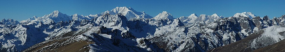
The India–Asia collision and Himalayan orogeny
The Himalayas are the archetypal collisional mountain belt — the largest, tallest, and most actively studied orogen on Earth. They owe their existence to the collision between the Indian subcontinent and the Eurasian plate, a process that began approximately 50–55 million years ago and continues to the present day.3, 5
Before collision, the Indian subcontinent was an isolated landmass drifting northward after rifting away from the supercontinent Gondwana. Between India and Eurasia lay the Tethys Ocean, a broad tropical sea whose oceanic crust was steadily being consumed by subduction beneath the southern margin of Eurasia. The closure of the Tethys left a geological signature that is still visible today: the Indus–Tsangpo suture zone, a narrow belt of crushed and metamorphosed oceanic rocks — including ophiolites — that marks the exact line of collision.17, 25
Upon collision, India did not simply stop. It continued to push northward, indenting into the Eurasian continent and driving crustal material sideways as well as upward. Peter Molnar and Paul Tapponnier famously demonstrated in the 1970s that the collision caused large-scale lateral extrusion of crustal blocks away from the indenter, producing the major strike-slip fault systems of Southeast Asia.3 Meanwhile, the convergence between India and Asia — estimated at roughly 5 centimeters per year since collision onset — has been accommodated by a combination of crustal shortening in the Himalayas, thickening of the Tibetan crust, and underthrusting of Indian lithosphere beneath Tibet.3, 5
The internal architecture of the Himalayan belt reflects a sequence of southward-propagating thrust faults that carried crustal slices over one another. The Main Central Thrust, separating high-grade metamorphic rocks of the Greater Himalayan Crystallines above from lower-grade sediments below, is one of the most studied shear zones in the world.27 The high-grade rocks it brought to the surface — granulites and migmatites that were once buried at depths of 30–40 kilometers — provide a direct window into the lower crust of a continent in the act of thickening. High temperatures at depth caused partial melting of the crust, producing granitic magmas that intruded the overlying rocks and are now exposed as the Himalayan leucogranites, dateable by uranium–lead geochronology and yielding ages in the range of 20–25 million years.27
Andean-type orogeny and fold-and-thrust belts
The Andes of South America provide the classic example of a mountain range built above an active subduction zone rather than by continent–continent collision. For at least the past 200 million years, the South American continent has overridden a succession of oceanic plates descending beneath its western margin. The modern Andes owe their principal phase of uplift to the Andean orogeny, a period of intense shortening that began around 25–30 million years ago and continues today.10
The mechanics of Andean orogeny differ from the Himalayan case in a crucial way: rather than two equally buoyant continental plates colliding head-on, subduction delivers a cold, dense oceanic slab beneath the continent at a steep angle. The descending slab generates arc volcanism — expressed in the spectacular chain of volcanoes running the length of the Andes — while the coupling between the slab and the overriding plate transmits compressive stresses inland, driving crustal shortening and thickening.9, 10 Estimates of crustal shortening in the central Andes reach 300–400 kilometers, concentrated in the sub-Andean fold-and-thrust belt along the eastern flank of the range, where sedimentary sequences have been folded and stacked like a crumpled tablecloth.11
Fold-and-thrust belts are a near-universal feature of convergent margins: thin-skinned belts form where sedimentary layers detach from the underlying basement along a décollement horizon and are transported toward the foreland as a wedge of stacked thrust sheets, while thick-skinned belts involve basement rocks in the deformation.20 The geometry of a fold-and-thrust belt can be understood mechanically as a critically tapered Coulomb wedge — a wedge of rock that maintains a constant taper angle by continuously accreting material at its toe and deforming internally to redistribute stress. This elegant model, developed in the early 1980s, accurately predicts the shape of accretionary prisms in subduction zones and the geometry of mountain-front thrust belts around the world.20
Metamorphism and deformation during orogeny
Orogeny does not only reshape the surface — it fundamentally transforms the rocks buried within the thickening crust. As crustal material is carried to greater depths by tectonic stacking, it encounters progressively higher temperatures and pressures, triggering metamorphism: the solid-state recrystallization of minerals into new assemblages stable under the prevailing conditions.13 The grades of metamorphism record, in effect, the maximum depths to which rocks were buried during the orogenic cycle, and the sequence of mineral zones across a mountain belt traces the thermal gradient at the time of metamorphism.
At shallow levels, the dominant deformation is brittle: rocks fracture, fault, and fold along discrete planes, producing the spectacular layered structures visible in road cuts through mountain ranges. At greater depths, where temperatures exceed roughly 300–400°C, rocks begin to behave in a ductile fashion, flowing and stretching without fracturing. Shear zones — anastomosing networks of intensely deformed, fine-grained rock — develop at these depths and record the large-scale movements between crustal blocks.1
At the highest metamorphic grades, reached in the deepest parts of thickened crust, temperatures may approach or exceed the melting point of water-bearing granite. Partial melts form and migrate upward, producing migmatites — rocks with interleaved layers of dark, restitic material and bright, leucocratic granitic veins — and, in some cases, large bodies of crustal granite. The Himalayan leucogranites, the S-type granites of the European Variscan belt, and the Idaho Batholith all testify to episodes of crustal melting during continental collision.27
Metamorphic core complexes represent a distinct structural regime that develops when a thickened orogenic crust begins to collapse under its own gravitational potential energy. As the overthickened crust spreads laterally, low-angle normal faults called detachments develop and exhume deep crustal rocks from depths of 20–30 kilometers to the surface. The rocks exposed in the footwall of the detachment are typically highly metamorphosed and mylonitized, recording ductile flow at elevated temperatures. The Basin and Range province of the western United States preserves some of the world's best-exposed metamorphic core complexes, formed during the Cenozoic collapse of the North American Cordillera.21
Erosion, isostatic rebound, and exhumation
Mountains begin to erode the moment they begin to rise. Rivers cut valleys, glaciers scour cirques and fjords, freeze-thaw action shatters rock faces, and mass-wasting processes carry debris to lowland basins. The net effect is a progressive reduction in the height and volume of the range — but the relationship between erosion and elevation is more complex than simple subtraction would suggest, because the removal of mass triggers isostatic rebound, bringing fresh rock from depth to replace what was removed above.22
In a tectonically active orogen where uplift rates and erosion rates are roughly balanced, the range may maintain nearly constant average elevation for millions of years while the rocks exposed at the surface are continuously younger and shallower than they once were. This apparent paradox — topographic steady state with rock-level descent — has been termed dynamic equilibrium and is well documented in the Swiss Alps, where thermochronological studies track the cooling histories of individual mineral grains as they rise from depth toward the surface.22, 23
The sediments eroded from mountain ranges accumulate in adjacent basins — foreland basins, delta systems, and ultimately the ocean floor — and their compositions, thicknesses, and ages provide an indirect record of the erosional history of the source range. Subsidence analysis of foreland basins like the Po Plain of northern Italy (in front of the Alps) or the Indo-Gangetic Plain (in front of the Himalayas) reveals how the load of the growing mountain belt flexes the lithosphere downward, creating accommodation space for several kilometers of sediment shed from the range.6, 22
When tectonic activity ceases — as when two continents finish colliding and convergence slows — erosion begins to outpace uplift, and the mountains gradually diminish. Yet isostatic rebound continues long after deformation has stopped, sustained by the continuing removal of mass from the surface. The result is that even a fully eroded orogen — reduced to a low-relief peneplain — preserves a thickened crustal root that extends deep into the mantle, a ghost of the mountains that once stood above it.6
Approximate maximum elevations and ages of major mountain belts3, 10, 12, 14, 24
Ancient mountain belts and past plate configurations
Not all mountains are young. The geological record preserves the eroded roots of mountain belts stretching back more than two billion years, and these ancient orogens serve as primary evidence for reconstructing the positions and movements of continents before the age of modern ocean floor. Because oceanic crust is continuously recycled by subduction, it survives in the rock record only as fragments preserved in ancient suture zones (ophiolites); the continents, by contrast, preserve long-lived records of the collisions, rifts, and amalgamations that have shaped their interiors.17, 18
The Caledonian orogeny, which peaked in the Silurian and Devonian periods (roughly 430–390 million years ago), records the closure of the Iapetus Ocean — a predecessor of the modern Atlantic — and the collision of the ancient continents of Laurentia (ancestral North America), Baltica (ancestral Scandinavia and northern Europe), and Avalonia (fragments of which underlie Wales, southern England, and parts of Atlantic Canada). The Caledonian belt today is expressed as the deeply eroded ranges of Scotland, Norway, Svalbard, and eastern Greenland, with matching segments visible in Newfoundland and New England.14 The recognition that these scattered remnants were once parts of a single continuous mountain belt — deduced from matching rock types, fossils, and structural orientations — was an early triumph of plate tectonic theory.
The Appalachian orogen of eastern North America records not one but several discrete collisional events spanning from the late Proterozoic through the Permian period. The Taconic, Acadian, and Alleghanian orogenies each record the successive accretion of volcanic arcs and continental fragments onto the eastern margin of Laurentia, with the final Alleghanian collision representing the assembly of the supercontinent Pangea as Africa converged with North America around 300 million years ago.12, 13 The Appalachians were once as tall as the modern Himalayas; today their maximum elevation barely exceeds 2,000 meters, a testament to 300 million years of erosion and isostatic subsidence following the cessation of tectonic activity.
Deeper in time, the Grenville orogen records a continental collision approximately 1.1–1.2 billion years ago that contributed to the assembly of the supercontinent Rodinia. The Grenville front — a major thrust belt that cuts across eastern North America from Mexico to Labrador — marks the suture zone of this ancient collision, now exposed at the surface after the removal of the mountain belt that once stood above it.15 Matching Grenville-age rocks are found in Scandinavia, Antarctica, India, and Australia, providing critical evidence for the reconstruction of Rodinia's geography.
Older still, the Trans-Hudson orogen of the Canadian Shield dates to approximately 1.8–1.9 billion years ago and represents one of the world's best-preserved Paleoproterozoic collision zones. It records the suturing of the Superior and Hearne cratons — ancient stable cores of Archean crust — along a boundary that was once a major mountain belt comparable in scale to the modern Himalayas.16 The preservation of high-pressure granulite terranes and eclogites within such ancient orogens demonstrates that the fundamental processes of deep crustal burial and metamorphism were operating in the same manner billions of years ago as they do today.
Ophiolites and terrane accretion
Two categories of geological evidence are particularly important for reconstructing the history of ancient mountain belts: ophiolites and accreted terranes. Both preserve records of tectonic events that would otherwise be entirely erased by the continuous recycling of ocean floor.
Ophiolites are slices of ancient oceanic crust and upper mantle that have been thrust onto a continental margin rather than subducted. They preserve the characteristic stratigraphy of the oceanic crust in sequence: dunites and harzburgites (depleted mantle) at the base, overlain by layered gabbroic cumulates, then a sheeted dyke complex (the fossil feeder system of a spreading ridge), then pillow lavas, and finally deep-sea sediments at the top.17, 18 The recognition that this stratigraphy matches what is known of modern ocean floor from drilling and dredging — and that it is preserved in mountain belts around the world — was a crucial confirmation of seafloor spreading. The Semail ophiolite of Oman, the Bay of Islands complex in Newfoundland, and the ophiolites of the Indus–Tsangpo suture zone in Tibet are among the most studied examples, each marking the position of an ocean that no longer exists.18
Terrane accretion describes the process by which fragments of crust with distinct geological histories — volcanic arcs, oceanic plateaus, microcontinents, seamounts — are rafted toward and attached to a larger continental mass by plate convergence. The term terrane (spelled to distinguish it from topographic "terrain") refers to a fault-bounded package of rock whose geological history differs markedly from adjacent packages.19 The North American Cordillera — the broad mountain system running from Alaska through western Canada and the United States to Baja California — is the world's best-documented example of a margin built largely by terrane accretion: over 200 distinct terranes have been identified, representing fragments of islands, plateaus, and arcs assembled onto North America over roughly 200 million years.19 The identification of exotic terranes — recognized by the mismatch of their fossil assemblages, magnetic declinations, or radiometric ages with those of the surrounding rock — allows geologists to trace the global wandering of crustal fragments across vanished ocean basins.
Together, ophiolites and terranes transform ancient mountain belts from purely local records into global archives. By matching ophiolite chemistries to known tectonic environments and by tracking the provenance of accreted terranes using isotopic fingerprinting, geologists can reconstruct the geography of continents and ocean basins at times far beyond the reach of any surviving seafloor — extending the readable record of plate tectonics back well over a billion years.18, 26
What ancient orogens tell us about Earth history
The spatial and temporal distribution of orogenic belts across the continents encodes a detailed history of Wilson cycles — the recurring opening and closing of ocean basins as continents rift apart, drift, and ultimately reassemble.

_2.jpg)
Geochronology is the primary tool for dating orogenic events. Uranium–lead dating of zircons — minerals that incorporate uranium but reject lead at the time of crystallization, making them ideal chronometers — can resolve the age of metamorphic and igneous events to within a few million years even in Precambrian terranes. The pattern of zircon ages across a mountain belt can map the successive pulses of metamorphism, magmatism, and cooling that characterize each phase of the orogenic cycle.15
Thermochronology — the use of isotopic systems with lower closure temperatures, such as fission-track dating of apatite or helium dating of zircon — complements geochronology by recording the cooling history of rocks as they rise toward the surface. Because cooling in the upper crust is principally controlled by exhumation — the removal of overlying rock by erosion — thermochronological data constrain the rates at which ancient mountain belts were eroded and their roots brought to the surface. In active belts like the Alps and Himalayas, such data reveal that the most rapid exhumation is focused in zones of highest precipitation, where rivers cut the deepest gorges, suggesting a strong coupling between climate, erosion, and the structural evolution of the mountain belt itself.23
The paleoelevation of ancient mountain belts can be estimated using stable isotope paleoaltimetry: precipitation at high elevation is enriched in lighter isotopes of oxygen and hydrogen because heavier isotopes preferentially rain out at lower elevations. By measuring the isotopic composition of ancient carbonate minerals or clay minerals formed from meteoric water, geologists can reconstruct the elevation at which those minerals formed millions of years ago.4, 23 Such reconstructions indicate that the Tibetan Plateau reached much of its modern elevation between 15 and 25 million years ago, with profound consequences for the global climate system: the plateau deflects the jet stream, intensifies the Asian monsoon, and, by presenting a vast surface for chemical weathering of silicate rocks, draws down atmospheric carbon dioxide over geological timescales.4
The study of orogeny thus links the interior workings of the planet — mantle convection, plate motion, crustal rheology — to the surface processes of erosion and sedimentation and, ultimately, to the evolution of climate and life. Mountain ranges are not merely scenic backdrops but dynamic engines of geological and biological change, their histories written in the mineralogy, structure, and isotopic composition of the rocks that once lay buried kilometers beneath them.
References
Elevation of the Tibetan Plateau and its effect on the general circulation of the atmosphere
On the deflection of the plumb-line in India and the hypothetical attraction of the Himalayan mountains
The Trans-Hudson orogen: a synthesis of available information and an assessment of future research needs
The growth of continents by crustal accretion: a challenge for concept of geodynamics