Overview
- Earth's continents periodically assemble into single landmasses called supercontinents and then fragment again, following the Wilson cycle of ocean basin opening and closing with a rough periodicity of 500–700 million years.
- At least four supercontinents are well documented — Pangaea (~335–200 Ma), Rodinia (~1.1–0.75 Ga), Columbia/Nuna (~1.8–1.3 Ga), and possibly Kenorland (~2.7 Ga) — each reconstructed from converging paleomagnetic, geochronological, and geological evidence.
- Supercontinents profoundly influenced global climate, ocean circulation, and biological evolution: their assembly drew down CO2 through continental weathering and restricted ocean currents, while their breakup triggered rifting volcanism, rising sea levels, and new evolutionary opportunities.
The continents of the Earth are not fixed in place. Driven by the convective churning of the mantle beneath them, they drift, collide, merge into vast landmasses, and then rift apart again in a cycle that has repeated at least four times over the past three billion years. These periodic assemblages of most or all continental crust into a single landmass are called supercontinents, and the recurring pattern of their formation and destruction is known as the supercontinent cycle. The cycle operates on a timescale of roughly 500 to 700 million years and has shaped nearly every aspect of Earth's surface environment, from the configuration of ocean basins and the routing of ocean currents to the composition of the atmosphere and the trajectory of biological evolution.6, 7
The Wilson cycle
The conceptual foundation of the supercontinent cycle rests on the work of the Canadian geophysicist J. Tuzo Wilson, who in 1966 asked a deceptively simple question: did the Atlantic Ocean close and then re-open?1 Wilson observed that the geological record of the Appalachian and Caledonian mountain belts in eastern North America and northwestern Europe preserves evidence of an ancient ocean — now called the Iapetus Ocean — that opened, widened, and then closed again before the present Atlantic formed in its place. This insight, that ocean basins have finite lifespans and can undergo complete cycles of opening and closing, became known as the Wilson cycle.
The Wilson cycle describes a sequence of stages. First, a continent rifts apart as extensional forces stretch and thin the lithosphere, producing a rift valley such as the present-day East African Rift.21 If rifting continues, the continent separates entirely and a new ocean basin forms between the diverging fragments, with a mid-ocean ridge generating fresh oceanic crust. The ocean widens as seafloor spreading continues — the Atlantic Ocean is currently in this expansive phase. Eventually, subduction initiates along one or both margins of the ocean, consuming oceanic lithosphere faster than the ridge can produce it. The ocean narrows, and the continents on its opposing margins converge. When they finally collide, a mountain belt marks the suture, and the ocean basin ceases to exist. The resulting enlarged continent may then participate in the next episode of rifting, beginning the cycle anew.1, 7
Applied to the global scale, the Wilson cycle predicts that continents should periodically sweep together into supercontinents and then disperse. The geological record confirms this prediction with increasing clarity as one moves forward in time: four supercontinents are now reasonably well documented, with progressively more speculative reconstructions extending into the Archean eon.6, 10
Pangaea
The most recent and best-documented supercontinent is Pangaea (from the Greek for "all lands"), the existence of which was first proposed by Alfred Wegener in 1912 and elaborated in his 1915 book Die Entstehung der Kontinente und Ozeane.2 Wegener noted the geometric fit of the Atlantic coastlines, the matching fossil assemblages of Glossopteris and Mesosaurus on now-separated continents, and the continuity of mountain belts and glacial deposits across ocean basins. Although his continental drift hypothesis was rejected during his lifetime for lack of a viable mechanism, the evidence he compiled was ultimately vindicated by the plate tectonic revolution of the 1960s.
The assembly of Pangaea was a protracted process spanning roughly 150 million years. It began in the late Devonian and early Carboniferous (~360 Ma) with the closure of the Rheic Ocean between Laurussia (the combined landmass of North America and northern Europe) and Gondwana (South America, Africa, Antarctica, India, and Australia). The collision produced the Variscan and Alleghanian orogenies, building mountain belts whose eroded remnants survive in the Appalachians, the European Hercynides, and the Ouachita Mountains.8 By the late Carboniferous to early Permian (~300 Ma), most continental crust had been incorporated into a single landmass stretching from pole to pole, surrounded by a global ocean called Panthalassa and partially enclosing a wedge-shaped embayment, the Tethys Sea, to the east.8
Pangaea began to fragment in the early to middle Jurassic, approximately 200–180 million years ago, when rifting split the supercontinent into a northern block (Laurasia) and a southern block (Gondwana). The initial rift developed along what is now the central Atlantic, separating North America from Africa. Gondwana itself subsequently broke apart in stages: Africa separated from South America during the Early Cretaceous (~130 Ma), India detached from Antarctica and Madagascar and began its rapid northward journey (~90 Ma), and Australia separated from Antarctica in the Eocene (~45 Ma).8, 20 The Atlantic Ocean has been widening ever since, and the Indian Ocean formed as India and Australia migrated northward. The collision of India with Eurasia beginning around 50 million years ago produced the Himalayas and the Tibetan Plateau — a continental collision that continues today.
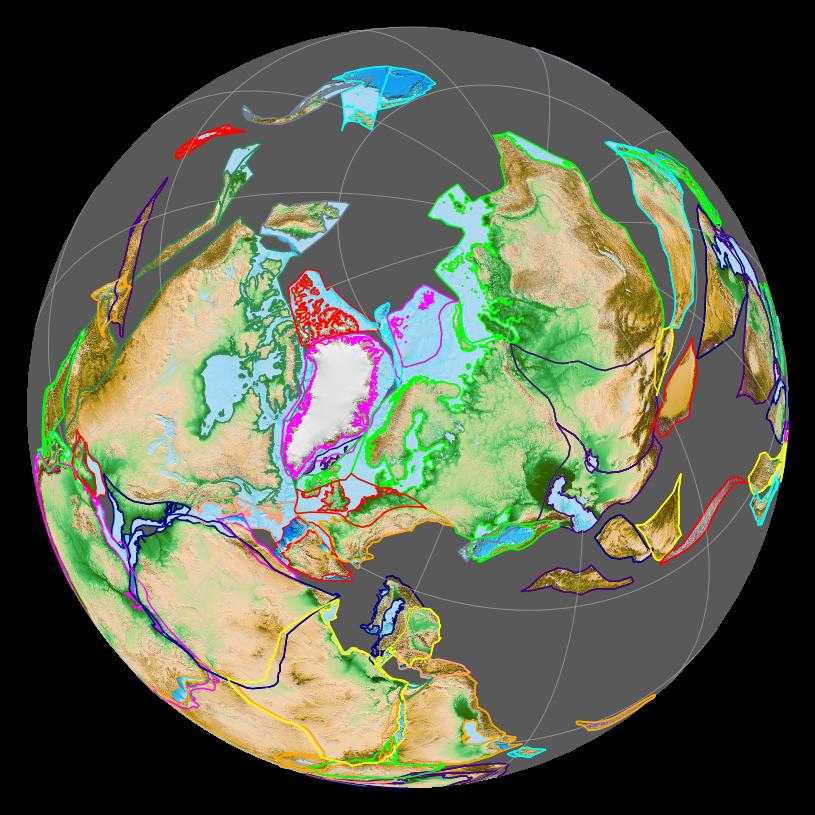
Rodinia
Before Pangaea, the geological record preserves evidence for an earlier supercontinent called Rodinia (from the Russian rodit', meaning "to give birth"). Rodinia assembled approximately 1.1 to 1.0 billion years ago through a series of orogenies collectively known as the Grenvillian event and began to break apart around 750 million years ago.3 The reconstruction of Rodinia is more uncertain than that of Pangaea because most of the oceanic crust that existed during its lifetime has long since been subducted, leaving geologists to rely primarily on paleomagnetic data, the correlation of orogenic belts, the matching of stratigraphic sequences, and the age distributions of detrital zircons preserved in sedimentary rocks on separate continents.
One of the most influential hypotheses for Rodinia's configuration is the SWEAT hypothesis (Southwest US–East Antarctic connection), proposed by Eldridge Moores in 1991, which placed the western margin of Laurentia (ancestral North America) against East Antarctica and Australia.11 The SWEAT model was supported by the observation that Grenville-age (~1.0–1.3 Ga) orogenic belts on several continents appeared to form a continuous chain when those continents were reassembled. Subsequent paleomagnetic work has refined and in some cases modified the original SWEAT configuration, but the core insight — that Laurentia occupied a central position within Rodinia, surrounded by the other cratons — remains widely accepted.3
The breakup of Rodinia is of particular interest because it appears to be causally linked to some of the most extreme climate perturbations in Earth's history. The rifting that dismembered the supercontinent produced extensive new continental margins and basaltic volcanism, which together increased the rate of silicate weathering and drew down atmospheric CO2. This reduction in greenhouse forcing, acting on a planet whose continents were then clustered at low latitudes (maximising the area of weatherable rock exposed to warm, wet tropical conditions), may have pushed Earth into the Snowball Earth glaciations of the Cryogenian period (~720–635 Ma), during which ice sheets may have reached equatorial latitudes.9, 3 The recovery from these extreme glaciations coincided with the Ediacaran radiation of complex multicellular life, and the subsequent Cambrian explosion occurred on continents dispersed by Rodinia's breakup.22
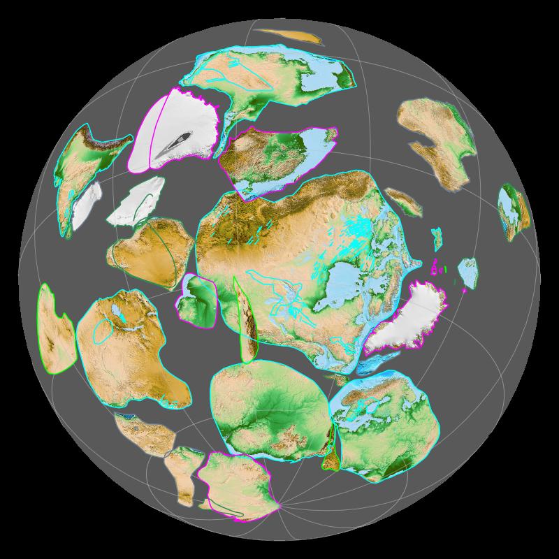
Columbia (Nuna)
The oldest supercontinent for which there is broad (though still debated) consensus is Columbia, also called Nuna. Columbia is thought to have assembled between approximately 2.1 and 1.8 billion years ago through a global episode of orogenesis that produced mountain belts whose remnants are preserved on virtually every craton: the Trans-Hudson orogen in North America, the Eburnean orogen in West Africa, the Limpopo Belt in southern Africa, and the Central Indian Tectonic Zone, among others.4, 25 The supercontinent appears to have remained coherent from roughly 1.8 to 1.5 billion years ago before fragmenting through a protracted episode of rifting and anorogenic magmatism.5
The reconstruction of Columbia relies heavily on paleomagnetic apparent polar wander paths, which track the movement of each continent relative to the magnetic poles through time. When the polar wander paths of separate continents overlap for a sustained interval, this indicates that those continents were joined. Zhao and colleagues in 2002 and 2009 proposed a detailed reconstruction in which the present-day eastern margin of India was juxtaposed with western North America, while the northern margin of the North China craton lay adjacent to North America's present-day northern margin.4 Meert and others have offered alternative configurations, reflecting the substantial uncertainties inherent in Paleoproterozoic paleomagnetism, but the existence of a major continental aggregation during this interval is now accepted by most workers in the field.5
The interval of Columbia's stability — roughly 1.8 to 1.3 billion years ago — coincides with one of the most geologically quiescent periods in Earth's history, sometimes referred to informally as the "boring billion." Global climate appears to have been relatively stable, and the rate of biological innovation was remarkably low compared to the Archean before it and the Neoproterozoic after it. Some researchers have suggested that the stability of Columbia's configuration suppressed the environmental perturbations — such as rifting volcanism, enhanced weathering, and nutrient runoff to the oceans — that drive evolutionary change.4, 5
Kenorland and the Archean supercontinents
Extending the supercontinent record deeper into the Archean eon becomes increasingly speculative. Kenorland is a hypothesized supercontinent that may have assembled approximately 2.7 billion years ago, inferred from the widespread occurrence of greenstone belts and granitoid intrusions of that age across the Superior, Slave, Pilbara, Kaapvaal, and other Archean cratons.10 The term itself is derived from the Kenoran orogeny, a major episode of crustal accretion in the Canadian Shield dated to approximately 2.7–2.5 Ga. However, whether these contemporaneous tectonic events represent the assembly of a true supercontinent — in the sense of a single coherent landmass encompassing most of Earth's continental crust — or merely a cluster of separate continental collisions remains a matter of debate.
Still more speculative is Vaalbara, proposed by Cheney in 1996 as perhaps the oldest identifiable supercontinent, based on the striking similarities between the Archean stratigraphic successions of the Kaapvaal craton of southern Africa and the Pilbara craton of Western Australia.18 Both cratons preserve remarkably similar sequences of volcanic and sedimentary rocks spanning 3.6 to 2.8 billion years, including banded iron formations, komatiitic lavas, and barite-bearing sediments. Paleomagnetic data from de Kock and colleagues have shown that the two cratons occupied similar paleolatitudes around 2.78 Ga, consistent with (though not proof of) their juxtaposition.24 Even if Vaalbara existed, it comprised only a small fraction of Earth's total continental crust and would not qualify as a supercontinent in the strict sense, but rather as a protocontinent or continental nucleus.
The fundamental difficulty of Archean reconstruction is that the available continental crust from that era is fragmentary, most of the contemporaneous oceanic crust has been recycled, and the paleomagnetic signal has been partially overprinted by subsequent metamorphism and deformation. Whether plate tectonics operated in its modern form during the Archean — with rigid plates, linear subduction zones, and Wilson-cycle ocean basins — remains actively debated, and alternative tectonic regimes such as "lid tectonics" or "plume tectonics" have been proposed for the early Earth.17
Timeline of supercontinents
Known and proposed supercontinents through Earth history3, 4, 8, 10, 18
| Supercontinent | Assembly (Ga) | Breakup (Ga) | Confidence | Key evidence |
|---|---|---|---|---|
| Vaalbara | ~3.6 | ~2.8 | Speculative | Matching stratigraphy of Kaapvaal and Pilbara cratons |
| Kenorland | ~2.7 | ~2.5 | Hypothetical | Contemporaneous greenstone belts and orogenies worldwide |
| Columbia (Nuna) | ~1.8 | ~1.3 | Well supported | Global 1.8–2.1 Ga orogenic belts; paleomagnetic data |
| Rodinia | ~1.1 | ~0.75 | Well established | Grenvillian orogenies; SWEAT hypothesis; detrital zircons |
| Pangaea | ~0.335 | ~0.200 | Definitive | Fossil correlation; continental fit; magnetic anomalies |
Paleomagnetic evidence
The primary tool for reconstructing ancient continental positions is paleomagnetism — the study of the ancient magnetic field recorded in rocks at the time of their formation. When igneous rocks cool through the Curie temperature, iron-bearing minerals such as magnetite align with the prevailing geomagnetic field and retain that orientation indefinitely (barring subsequent reheating or deformation). The inclination of this remanent magnetization indicates the paleolatitude at which the rock formed, because Earth's magnetic field lines are horizontal at the equator and vertical at the poles.10
By compiling paleomagnetic data from rocks of many ages on a single continent, geologists construct an apparent polar wander (APW) path — a track showing the apparent motion of the magnetic pole relative to that continent through time. Because it is the continent, not the pole, that moves (the geomagnetic pole remains approximately aligned with Earth's spin axis over millions of years), the APW path is actually a record of the continent's drift across the globe. When two continents share a common APW path over a given interval, it indicates that they were joined and moving together during that time; when their paths diverge, it marks the onset of their separation.10
The power and the limitation of paleomagnetism lie in the same fact: inclination constrains paleolatitude but not paleolongitude, because identical inclinations occur at the same latitude everywhere around the globe. Reconstructions therefore depend on combining paleomagnetic data with independent geological constraints — matching orogenic belts, correlating stratigraphic sequences, and comparing the age spectra of detrital zircons — to determine not only the latitude but also the relative longitudinal positions of ancient continents.3, 10
Driving mechanisms
The forces that drive the supercontinent cycle are ultimately rooted in the dynamics of mantle convection, but the precise relationship between mantle flow and continental assembly remains an area of active research.

The most widely discussed mechanism is the thermal insulation effect. Continental lithosphere is thicker and less thermally conductive than oceanic lithosphere, and a supercontinent acts as a thermal blanket over the mantle, trapping heat beneath it. Over tens of millions of years, this insulation causes the sub-continental mantle to warm, generating broad upwellings and eventually rifting the supercontinent apart. Don Anderson articulated this idea in 1982, arguing that the thermal blanketing of the mantle by a large continent would inevitably lead to its fragmentation.14 Numerical models by Zhong and colleagues have confirmed that the presence of a supercontinent reorganises the pattern of mantle convection, shifting from a configuration dominated by subduction-driven downwellings (which help assemble the continent) to one dominated by a broad upwelling beneath the supercontinent (which tears it apart).13
A related concept is the role of superplumes — unusually large and energetic mantle upwellings that may originate from the core-mantle boundary. Kent Condie has documented episodic peaks in the global production of juvenile continental crust, large igneous provinces, and other indicators of deep-mantle activity, and has argued that these peaks correspond to superplume events that coincide with, and may help drive, the breakup phases of supercontinent cycles.17 The two large low-shear-velocity provinces (LLSVPs) visible in seismic tomography beneath Africa and the Pacific — sometimes called "superplume" structures — may represent long-lived thermochemical anomalies that influence the surface pattern of plate tectonics on timescales of hundreds of millions of years.19
On the assembly side of the cycle, the primary driver is subduction. As oceanic lithosphere ages, cools, and becomes denser, it founders into the mantle at subduction zones, pulling plates toward trenches and drawing continents together. The closure of intervening ocean basins by subduction is the mechanism by which dispersed continents converge and collide to form a new supercontinent.7 Li and Zhong have modelled the coupled evolution of plates and mantle flow and shown that the degree-two (two-cell) pattern of convection associated with a supercontinent transitions to a higher-degree pattern during dispersal, and then back to degree-two as the next supercontinent assembles — producing a self-sustaining oscillation with a period of several hundred million years.19
Effects on climate and life
Supercontinents exert a profound influence on global climate through several interconnected mechanisms. The most direct is the alteration of ocean circulation patterns. When most continental crust is gathered into a single landmass, the remaining global ocean (such as Panthalassa during the time of Pangaea) lacks the narrow, enclosed basins and meridional passages that drive the thermohaline circulation characteristic of the modern Atlantic. Climate modelling by Kutzbach and Gallimore has shown that Pangaea's configuration, straddling the equator, produced extreme continentality — intensely hot, arid interiors with extreme seasonal temperature swings — and a weakened meridional overturning circulation compared to the present.16
Continental weathering provides another critical link between supercontinent configuration and climate. The chemical weathering of silicate rocks on land consumes atmospheric CO2, which is washed to the oceans as bicarbonate and eventually precipitated as carbonate sediment, permanently removing carbon from the atmosphere. When large continental areas are positioned at low latitudes, where temperatures and precipitation are high, weathering rates increase and CO2 drawdown accelerates, cooling the planet. The assembly of Gondwana over the South Pole during the late Paleozoic coincided with one of the most intense glaciations of the Phanerozoic eon, the Carboniferous-Permian ice age, during which atmospheric CO2 fell from more than 1,000 ppm to near pre-industrial levels.15 Conversely, the rifting volcanism that accompanies supercontinent breakup releases CO2 faster than weathering can consume it, warming the climate — the Mesozoic greenhouse conditions that followed the breakup of Pangaea exemplify this effect.12
The biological consequences of the supercontinent cycle are equally far-reaching. The assembly of Pangaea in the late Paleozoic unified terrestrial faunas, eliminating the oceanic barriers that had previously separated continental biotas and producing a single, cosmopolitan terrestrial biome. Marine biodiversity, meanwhile, declined as the total length of coastline decreased and the area of shallow continental shelves was reduced by the amalgamation of margins into continental interiors.6 The end-Permian mass extinction — the most severe in Earth's history, eliminating roughly 90 percent of marine species — occurred during the maximum assembly of Pangaea, and some researchers have linked the extinction to the environmental consequences of the supercontinent's configuration, including ocean stagnation, marine anoxia, and the eruption of the Siberian Traps large igneous province.8
The breakup of a supercontinent creates new continental margins, opens new ocean basins, and generates fresh shallow-water habitats — all of which promote diversification. The Cambrian explosion of animal diversity followed the dispersal of the continents that had constituted Rodinia, and the great Mesozoic and Cenozoic radiations of terrestrial vertebrates, flowering plants, and marine invertebrates tracked the progressive fragmentation of Pangaea.22 Each fragmentation event isolated populations on separate continents, creating the biogeographic provinces whose modern distributions — marsupials in Australia, lemurs in Madagascar, New World monkeys in South America — reflect the history of continental dispersal.
The next supercontinent
If the supercontinent cycle continues, the present dispersal of continents will eventually reverse, and a new supercontinent will assemble in the geologically distant future. Several models have been proposed for its configuration, each based on different assumptions about which ocean basins will close and which will survive.
The Pangaea Proxima (or Pangaea Ultima) model, developed by Christopher Scotese, assumes that the Atlantic Ocean will eventually begin to close as new subduction zones develop along the passive margins of the Americas. Under this scenario, the Americas, Europe, and Africa would converge to form a new supercontinent centred roughly where Pangaea was, with the Pacific Ocean remaining as the successor to Panthalassa.20
The Amasia model, proposed by Mitchell and colleagues in 2012, takes a different approach. Based on an analysis of the relationship between successive supercontinents and the minimum moment of inertia of their continental distributions, Mitchell argued that each new supercontinent tends to form roughly 90 degrees from its predecessor. Under this model, the Arctic Ocean and Caribbean Sea close as the Americas drift northward across the Arctic to merge with Eurasia, assembling a supercontinent centred over the North Pole — hence the name Amasia.23
A third scenario, Novopangaea, assumes that the Pacific Ocean closes while the Atlantic continues to open, carrying the Americas westward to collide with eastern Asia and Australia. All three models converge on a timescale of approximately 200 to 300 million years for the next supercontinent's assembly, consistent with the roughly 500–700 million year spacing observed in the geological record.6, 23 The deep uncertainties in these projections reflect the difficulty of predicting where new subduction zones will initiate — a process that remains one of the least understood aspects of plate tectonics.
Regardless of which model proves correct, the general prediction is secure: the supercontinent cycle is a fundamental mode of Earth's geological behaviour, driven by the thermodynamics of the mantle and the mechanics of plate motion, and the present dispersed configuration of the continents is a transient state in an ongoing oscillation that has persisted for at least three billion years.6, 7
References
Supercontinent–superplume coupling, true polar wander and plume mobility: plate dominance in whole-mantle tectonics