Overview
- The Himalayan orogeny began approximately 50-55 million years ago when the Indian plate, after rifting from Gondwana and traversing the Tethys Ocean at speeds up to 18-20 cm/year, collided with Eurasia in the most dramatic continent-continent collision of the Cenozoic era.
- The collision has produced the Himalayas (containing all 14 peaks above 8,000 m), doubled the crustal thickness beneath Tibet to 70-80 km, and created the Tibetan Plateau, the world's highest and largest plateau at an average elevation exceeding 4,500 m over 2.5 million km².
- The ongoing collision generates devastating seismicity along the Main Himalayan Thrust, has reshaped global climate through enhanced silicate weathering and monsoon intensification, and continues to build the world's highest mountains at convergence rates of approximately 17-21 mm/year.
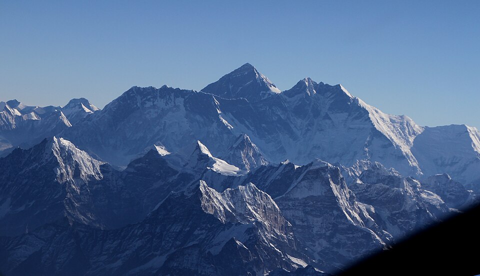
The Himalayan orogeny is the ongoing tectonic event produced by the collision of the Indian plate with the Eurasian plate, a process that began approximately 50 to 55 million years ago and continues to this day.2, 7 It is the most dramatic example of continent-continent collision on the modern Earth and has created the highest mountain range on the planet: the Himalayas, which stretch approximately 2,400 kilometres across South Asia and contain all fourteen peaks that exceed 8,000 metres in elevation, including Mount Everest at 8,848.86 metres.2, 20 Beyond the mountains themselves, the collision has built the Tibetan Plateau — the world's largest and highest plateau — reshaped global climate patterns, driven the Asian monsoon system, and generated some of the most devastating earthquakes in recorded history.1, 3, 5
The India-Eurasia collision represents the most significant tectonic event of the Cenozoic era. Unlike the subduction of oceanic lithosphere, in which dense oceanic crust descends readily into the mantle, the collision of two continental plates involves buoyant crust on both sides of the boundary, producing intense crustal shortening, folding, thrust faulting, and a doubling of crustal thickness.2, 4 The convergence between India and southern Tibet continues at rates of approximately 17 to 21 millimetres per year, as measured by GPS geodesy, ensuring that the Himalayas remain a dynamic and actively growing mountain belt.12, 14
The journey of India
The story of the Himalayan orogeny begins not in Asia but in the Southern Hemisphere, where the Indian subcontinent was once embedded within the supercontinent Gondwana. India was positioned adjacent to East Africa, Madagascar, and Antarctica, connected to these landmasses as part of the vast Gondwanan assembly that dominated the Southern Hemisphere through much of the Paleozoic and Mesozoic eras.2, 10 The breakup of Gondwana proceeded in stages: India separated from Africa and Madagascar between approximately 160 and 90 million years ago and began its long northward journey across the Tethys Ocean, the vast seaway that separated Gondwana from the northern supercontinent Laurasia.2, 11
Paleomagnetic data have revealed that the northward migration of the Indian plate was remarkably rapid. During the Late Cretaceous, approximately 67 to 52 million years ago, India moved northward at velocities of 18 to 20 centimetres per year, making it one of the fastest-moving continental plates in the geological record.8, 10, 11 This extraordinary speed has been attributed to the combination of slab pull from the subduction of Tethyan oceanic lithosphere ahead of India, the push from the Reunion mantle plume beneath the Indian plate, and the relative thinness of the Indian lithosphere, which reduced the resistance to plate motion.10 More recently, Jagoutz and colleagues proposed that India's anomalous velocity can be explained by double subduction: geological data from the Himalayan region support the existence of two nearly parallel, northward-dipping subduction zones between the Indian and Eurasian plates during the Late Cretaceous, and numerical models demonstrate that the combined pull of two subducting slabs generates convergence rates matching the observed paleomagnetic record.22 As India raced northward, the Tethys Ocean was progressively consumed by subduction beneath the southern margin of Eurasia, narrowing the gap between the two continents.
The precise timing of initial contact between India and Eurasia remains a subject of active debate, but the most widely accepted estimates place the onset of collision between approximately 55 and 50 million years ago, in the Early Eocene.7, 16 Rowley's 1996 review of stratigraphic data concluded that in the western Himalaya (the Zanskar-Hazara region), the youngest marine sediments constraining the collision age are Late Ypresian, approximately 52 million years old, while farther east the collision may have been slightly younger.7 Paleomagnetic reconstructions by Patriat and Achache indicated that initial contact between the Indian continent and the Ladakh arc occurred around 50 to 54 million years ago.11 More recent biostratigraphic and palaeomagnetic work by Najman and colleagues confirmed that the youngest marine facies preserved in the Himalayan suture zone are 50.6 to 52.8 million years old, consistent with collision onset in the Early Eocene.16 Van Hinsbergen and colleagues have proposed an alternative "Greater India Basin" model, in which a large ocean or extended continental basin existed between Greater India and stable India, potentially allowing initial contact between India and Asia to have occurred earlier than previously thought, with the suture zone recording the closure of a back-arc basin rather than the main Tethyan ocean.23 Following the collision, the velocity of the Indian plate dropped dramatically, from approximately 18 to 20 centimetres per year to roughly 4.5 to 5 centimetres per year, as the resistance of the continental collision replaced the easy subduction of oceanic lithosphere.10, 19
Collision mechanics and crustal thickening
The fundamental distinction between the Himalayan orogeny and the more common oceanic-continental convergent boundaries lies in the buoyancy of the colliding plates. In oceanic subduction, dense oceanic lithosphere sinks readily into the mantle beneath the lighter overriding plate. In continent-continent collision, however, both plates are composed of relatively buoyant continental crust with a density significantly lower than the underlying mantle, meaning that neither plate can be efficiently subducted.2, 4 The result is intense crustal shortening: the rocks of both plates are folded, faulted, and stacked upon one another through a series of major thrust systems, dramatically thickening the crust in the collision zone.
Paleomagnetic reconstructions indicate that approximately 2,600 plus or minus 900 kilometres of convergence has been accommodated since the onset of collision, distributed between crustal shortening within the Himalayan fold-thrust belt, underthrusting of Indian lithosphere beneath Tibet, and lateral extrusion of crustal blocks to the east and southeast.11, 2 Van Hinsbergen and colleagues have estimated that the total convergence since 52 million years ago may have reached approximately 3,600 kilometres, with a substantial portion of the discrepancy between convergence and documented shortening explained by the subduction of highly extended continental and oceanic Indian lithosphere between approximately 50 and 25 million years ago.23 The Indian plate has not simply stopped at the collision boundary; rather, it continues to drive northward and underthrust beneath the Eurasian plate, with the Indian continental lithosphere extending several hundred kilometres beneath southern Tibet.2, 4 Seismological studies have confirmed that the crust beneath the Tibetan Plateau is approximately 70 to 80 kilometres thick, roughly double the normal continental crustal thickness of 35 to 40 kilometres, a direct consequence of the collision-driven shortening and stacking.2, 9
The deformation is accommodated along a series of major south-dipping thrust faults that divide the Himalayan orogen into distinct structural zones. From south to north, the principal faults are the Main Frontal Thrust, the Main Boundary Thrust, and the Main Central Thrust, each of which has carried progressively deeper and more metamorphosed rocks southward over shallower, less deformed units.6, 21 Beneath all of these surface structures lies the Main Himalayan Thrust, a gently dipping megathrust fault upon which the entire Himalayan wedge is sliding over the underthrusting Indian plate. GPS geodesy has demonstrated that this megathrust is locked from the surface to depths of approximately 15 to 20 kilometres, accumulating elastic strain that is periodically released in great earthquakes.14, 4
The Indus-Yarlung suture zone
The Indus-Yarlung suture zone (also called the Indus-Tsangpo suture zone) is the actual plate boundary along which India and Eurasia are joined, running approximately 2,000 kilometres along the northern edge of the Himalayan belt from Nanga Parbat in the west to Namche Barwa in the east.2, 20 This suture marks the site where the Tethys Ocean was finally consumed and the two continental masses came into direct contact. It is not a simple line but a broad zone of intensely deformed and tectonically mixed rocks, including ophiolites, mélange, flysch sequences, and volcanic arc remnants.2, 21
The ophiolites within the suture zone are among the most compelling pieces of evidence that an ocean once separated India from Asia. These are fragments of oceanic crust and upper mantle — basalts, gabbros, sheeted dyke complexes, and ultramafic peridotites — that were scraped off the subducting Tethyan ocean floor and emplaced onto the continental margin during the final stages of ocean closure and the initial collision.2, 20 Structural and stratigraphic data indicate that ophiolite emplacement over the Tethyan Himalaya occurred in the latest Cretaceous, approximately 70 to 65 million years ago, preceding the final continent-continent collision by 10 to 15 million years and recording the last stages of subduction of Neo-Tethyan oceanic lithosphere.20, 21
The cessation of marine sedimentation within the suture zone provides a critical constraint on the timing of collision. The youngest marine sedimentary rocks found in the suture — shallow-marine limestones and foraminiferal-bearing shales — are dated to the Early Eocene, approximately 50 to 52 million years ago, after which only continental clastic sediments are found, indicating that the seaway had been eliminated and the two continents were in direct contact.7, 16 This transition from marine to continental sedimentation is one of the most robust lines of evidence for the collision timing and has been documented at multiple locations along the length of the suture zone.7
Structure of the Himalayan belt
_3.jpg)
The pioneering work of Augusto Gansser in 1964 established the framework for understanding the Himalayan orogen as a series of laterally continuous structural and lithological zones, separated by major thrust faults and arranged in a systematic pattern from south to north.2, 21 This zonation, refined by subsequent decades of geological mapping, reflects the progressive stacking of successively deeper crustal slices as the collision compressed and telescoped what was once a broad expanse of continental margin and ocean floor into a narrow, towering belt of mountains.
The southernmost zone is the Sub-Himalaya, also known as the Siwalik Hills, a belt of low foothills composed of Miocene to Pleistocene molasse sediments — sandstones, siltstones, and conglomerates derived from the erosion of the rising Himalayas and deposited in the foreland basin of the Indo-Gangetic Plain. The Sub-Himalaya is bounded to the south by the Main Frontal Thrust and to the north by the Main Boundary Thrust.6, 21 North of the Main Boundary Thrust lies the Lesser Himalaya, composed of Proterozoic to Paleozoic sedimentary and low-grade metamorphic rocks, including thick sequences of limestone, quartzite, and slate. The Lesser Himalaya typically forms moderate-elevation ranges and valleys and contains some of the oldest rocks exposed in the orogen.2, 6
The Greater Himalaya, or Higher Himalayan Crystalline Sequence, lies above the Main Central Thrust and constitutes the backbone of the range. It is composed of high-grade metamorphic rocks — gneisses, migmatites, and schists — that were buried to depths of 20 to 35 kilometres and heated to temperatures exceeding 700 degrees Celsius during the collision.2, 13 Leucogranite intrusions, formed by the partial melting of these deeply buried continental rocks, are a distinctive feature of the Greater Himalaya and provide direct evidence of the extreme thermal conditions generated by crustal thickening.2 The Greater Himalaya is bounded above by the South Tibetan Detachment System, a major normal-sense fault zone that has played a critical role in the exhumation of the high-grade rocks by allowing the overlying Tethyan sedimentary rocks to slide northward off the rising crystalline core.2, 20
Above the South Tibetan Detachment lies the Tethyan Himalaya, a thick sequence of Paleozoic and Mesozoic sedimentary rocks — limestones, shales, and sandstones — that were originally deposited on the passive northern margin of the Indian continent as it faced the Tethys Ocean. These rocks are generally unmetamorphosed or only weakly metamorphosed and preserve a rich fossil record of marine life from the Tethyan seaway.2, 7
Structural zones of the Himalayan orogen from south to north2, 6, 21
| Zone | Bounding faults | Dominant lithology | Age of rocks |
|---|---|---|---|
| Sub-Himalaya (Siwaliks) | MFT (south) – MBT (north) | Molasse sandstone, siltstone, conglomerate | Miocene–Pleistocene |
| Lesser Himalaya | MBT (south) – MCT (north) | Low-grade metasediments, quartzite, slate | Proterozoic–Paleozoic |
| Greater Himalaya | MCT (south) – STD (north) | High-grade gneiss, migmatite, leucogranite | Proterozoic (metamorphosed Cenozoic) |
| Tethyan Himalaya | STD (south) – IYSZ (north) | Sedimentary: limestone, shale, sandstone | Paleozoic–Mesozoic |
| Indus-Yarlung Suture Zone | Northern plate boundary | Ophiolites, mélange, flysch | Mesozoic–Early Cenozoic |
The abbreviations in the table refer to the major thrust systems: MFT (Main Frontal Thrust), MBT (Main Boundary Thrust), MCT (Main Central Thrust), STD (South Tibetan Detachment), and IYSZ (Indus-Yarlung Suture Zone). Together, these structures record the progressive absorption of convergence through south-directed thrusting, in which deeper and more internal slices of the orogen have been sequentially carried over shallower, more external units in what geologists term a forward-breaking thrust sequence.6, 4
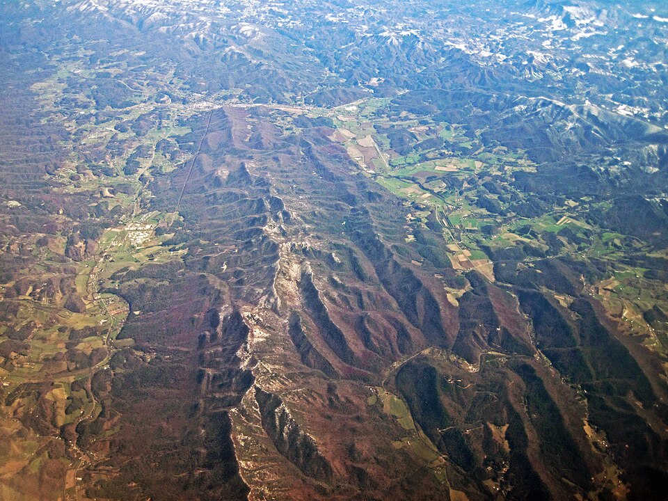
The Tibetan Plateau and lateral extrusion
.jpg)
.jpg)
The collision of India with Eurasia has not only created the Himalayan mountain belt but has also produced the Tibetan Plateau, the largest and highest plateau on Earth. Covering an area of approximately 2.5 million square kilometres — roughly the size of western Europe — and reaching an average elevation exceeding 4,500 metres, the plateau is often referred to as the "Roof of the World" and sometimes as the "Third Pole" for the vast ice reserves it harbours.9, 1 The mechanism by which the plateau attained its extraordinary elevation has been one of the most debated questions in tectonics for the past half century.
In their landmark 1975 paper, Molnar and Tapponnier proposed that the collision caused large-scale lateral extrusion of crustal blocks, in which segments of Asian crust were squeezed eastward and southeastward away from the collision zone along major strike-slip faults such as the Altyn Tagh, Kunlun, and Red River faults.1 This model explained the pattern of active faulting across Central and East Asia as a far-field consequence of the India-Eurasia collision, with deformation extending thousands of kilometres from the plate boundary into the continental interior. Subsequent work has confirmed that active deformation related to the collision affects an area extending from the Himalayas to Lake Baikal in Siberia, a north-south distance of more than 3,000 kilometres.1, 2
Royden, Burchfiel, and van der Hilst argued in 2008 that the geological evolution of the plateau involved distinct phases: early crustal shortening in western and central Tibet, followed by eastward growth of the plateau through lower crustal flow, a process influenced by the cessation of rapid trench migration in the western Pacific approximately 15 to 20 million years ago.9 Their model proposed that as Pacific trench rollback slowed, the escape of crustal fragments eastward from the collision zone was impeded, contributing to the onset of rapid surface uplift and crustal thickening in eastern Tibet. Seismic imaging has revealed low-velocity zones in the deep crust beneath eastern Tibet, consistent with the presence of partially molten or rheologically weak crustal material that may be flowing laterally under the pressure gradient created by the enormous elevation of the plateau.9
Channel flow and the role of erosion
An influential model proposed by Beaumont and colleagues in 2001 invoked channel flow in the middle and lower crust of Tibet to explain the exhumation of deeply buried, high-grade metamorphic rocks in the Greater Himalaya. In this model, the enormously thickened and radiogenically heated Tibetan crust develops a weak, partially molten mid-crustal layer that flows laterally under the pressure gradient created by the elevation difference between the plateau and the surrounding lowlands.13 Where this channel encounters the steep topographic front of the Himalayas and is coupled to intense erosion driven by the monsoon, the weak crustal material is extruded to the surface, explaining the simultaneous operation of the Main Central Thrust (a thrust fault carrying deep rocks upward) and the South Tibetan Detachment (a normal fault allowing rocks above to slide northward) — a paradoxical pairing of contractional and extensional faulting that had long puzzled geologists.13, 2
The channel flow model highlights the profound role that erosion plays in shaping the orogen. Rather than being merely a passive agent of destruction, erosion actively controls where deep crustal material is brought to the surface by focusing denudation at the steep topographic front where monsoonal precipitation is highest.13, 4 This coupling between tectonic processes and surface processes creates a feedback loop: erosion removes material from the surface, reducing the load on the rising mountain belt and drawing more deep crustal material upward through the channel, which in turn maintains the steep topography that focuses precipitation and erosion.4 The highest rates of rock uplift and exhumation in the Himalaya occur at the syntaxial bends at either end of the range — Nanga Parbat in the west and Namche Barwa in the east — where powerful rivers such as the Indus and Brahmaputra cut deeply into the orogen, driving rapid exhumation at rates approaching 5 to 10 millimetres per year.4, 2
Climate and weathering feedbacks
The Himalayan orogeny has influenced global climate on timescales ranging from millions of years to seasonal cycles. In 1992, Raymo and Ruddiman proposed a hypothesis that has become one of the most influential ideas in paleoclimatology: that the uplift of the Himalayas and the Tibetan Plateau intensified the chemical weathering of silicate rocks, drawing down atmospheric carbon dioxide and driving the progressive global cooling that has characterised the Cenozoic era.3 The mechanism is straightforward in principle: silicate weathering reactions consume CO2 from the atmosphere, and the products are carried by rivers to the ocean, where carbon is ultimately sequestered in marine carbonate sediments. Because weathering rates increase with temperature, rainfall, and the availability of fresh mineral surfaces exposed by erosion, the combination of an enormous, rapidly eroding mountain belt and an intensely monsoonal climate creates conditions that maximise the rate of atmospheric CO2 drawdown.3
The elevated Tibetan Plateau acts as an elevated heat source that drives the Asian monsoon system by creating a strong thermal contrast between the heated plateau surface and the cooler Indian Ocean to the south, drawing moisture-laden air northward during summer months.3, 9 The monsoon delivers enormous quantities of precipitation to the southern flank of the Himalayas, with some stations in northeast India receiving more than 11,000 millimetres of annual rainfall. This intense precipitation drives rapid erosion, which in turn exposes fresh rock surfaces for chemical weathering, creating a positive feedback loop between tectonic uplift, climate, weathering, and CO2 drawdown.3, 4
The rivers draining the Himalayas — including the Ganges, Brahmaputra, and Indus — carry prodigious volumes of sediment eroded from the rapidly uplifting mountains. This sediment has built the world's two largest submarine fans: the Bengal Fan, extending approximately 3,000 kilometres into the Bay of Bengal with a maximum thickness of 16.5 kilometres, and the Indus Fan in the Arabian Sea.17 The Bengal Fan alone covers approximately 3 million square kilometres, making it the largest sedimentary body on Earth, and its stratigraphy preserves a detailed record of Himalayan erosion history extending back to the Eocene.17 The enormous flux of chemically reactive sediment delivered to the oceans by Himalayan rivers has influenced global ocean chemistry, including the strontium isotope ratio of seawater, which shows a sharp increase beginning around 40 million years ago that has been attributed to the enhanced weathering of radiogenic Himalayan rocks.3 Although the precise contribution of Himalayan weathering to Cenozoic cooling remains debated — some researchers argue that the weathering flux is insufficient to account for the observed cooling, while others point to additional feedbacks involving organic carbon burial — the Raymo-Ruddiman hypothesis remains a cornerstone of the field and has inspired decades of research into the coupling between tectonics and climate.3
Seismic hazards and the 2015 Nepal earthquake
The Himalayan collision zone is one of the most seismically hazardous regions on Earth. The convergence between India and southern Tibet, measured by GPS at approximately 17.8 plus or minus 0.5 millimetres per year in central and eastern Nepal and 20.5 plus or minus 1 millimetre per year in western Nepal, is accommodated primarily by episodic slip on the Main Himalayan Thrust, the gently north-dipping megathrust fault that underlies the entire Himalayan wedge.14 This fault is locked from the surface to depths of approximately 15 to 20 kilometres beneath the Higher Himalaya, accumulating elastic strain that is released in great earthquakes at intervals of centuries to millennia.14, 4
The historical and instrumental record of Himalayan earthquakes is dominated by a series of catastrophic events. The 1934 Bihar-Nepal earthquake (magnitude 8.1) devastated much of the central Himalayan foreland, while the 1950 Assam earthquake (magnitude 8.6), one of the largest continental earthquakes ever recorded, ruptured the eastern syntaxis of the Himalayan arc.5 The 2005 Kashmir earthquake (magnitude 7.6) killed approximately 87,000 people and destroyed nearly 780,000 buildings in Pakistan and India.5
The 2015 Gorkha earthquake in Nepal (magnitude 7.8) killed approximately 9,000 people and caused widespread destruction in the Kathmandu Valley. Analysis by Avouac and colleagues demonstrated that the rupture unzipped the lower edge of the locked portion of the Main Himalayan Thrust, propagating eastward for approximately 150 kilometres at depths of 10 to 15 kilometres, while leaving the shallower, more frontal portion of the fault still locked.15 This partial rupture pattern means that accumulated strain on the updip portion of the megathrust was not fully released, implying a continuing and perhaps increased hazard for future earthquakes in the region.15, 5
Bilham's comprehensive review of Himalayan seismicity has highlighted that large segments of the Himalayan arc have not ruptured in great earthquakes for several centuries, accumulating a slip deficit that may be sufficient to produce magnitude 8.5 or greater events when eventually released. His analysis concluded that approximately two-thirds of the Himalayan arc is sufficiently mature to host a great earthquake of magnitude 8 or larger, and that ten of fifteen assessed segments are overdue for significant seismic release.5 With hundreds of millions of people living in the densely populated Indo-Gangetic Plain immediately south of the Himalayan front, the seismic hazard posed by the Main Himalayan Thrust represents one of the most significant natural risks facing South Asia.5, 14
Convergence rates across the Nepal Himalaya by GPS geodesy14, 18
The bar chart illustrates the distribution of convergence across the Himalayan belt. The total convergence rate between India and stable Eurasia is approximately 34 to 40 millimetres per year, of which roughly half is absorbed by shortening and underthrusting in the Himalayan fold-thrust belt, as measured by GPS stations in Nepal, and the remainder by deformation distributed across the Tibetan Plateau and the broader Asian continent.18, 19, 14
The ongoing collision and its broader significance
The Himalayan orogeny is not a relic of the geological past but an active, ongoing process. GPS measurements demonstrate that India continues to converge with Eurasia at a total rate of approximately 34 to 40 millimetres per year, with roughly half absorbed in the Himalayan belt and the remainder distributed across the Tibetan Plateau and the broader Asian continent.18, 19 Copley, Avouac, and Royer demonstrated that the dramatic Cenozoic slowdown of the Indian plate — from approximately 15 centimetres per year to 4 centimetres per year between 50 and 35 million years ago — was primarily caused by the resistive force of crustal thickening in the Himalaya-Tibet system, which they estimated at approximately 5 to 6 × 10¹² newtons per metre of plate boundary.19
The lateral extent of deformation driven by the India-Eurasia collision is extraordinary. Active faulting, seismicity, and crustal shortening extend from the Himalayan front northward across the Tibetan Plateau to the Tien Shan and Altai mountains of Central Asia, and eastward along the strike-slip faults of China and Southeast Asia to the coast of the South China Sea.1, 9 The 2008 Sichuan earthquake (magnitude 7.9) in China and the ongoing seismicity of the Tien Shan are manifestations of the same collision that builds the Himalayas, transmitted through the weak continental lithosphere of Asia over distances exceeding 3,000 kilometres from the plate boundary.1
The Himalayan orogeny thus stands as the preeminent natural laboratory for studying the processes of continental collision. Its scale, its accessibility, and the wealth of geological, geophysical, and geodetic data that have been collected over more than a century of scientific investigation make it the type example against which all other continent-continent collisions — past and present — are compared.2, 20 From the initial rifting of India from Gondwana to the continuing growth of the world's highest peaks, the Himalayan orogeny encapsulates the full spectrum of tectonic processes that shape the surface of the Earth and influence the planet's climate, hydrology, and habitability over geological time.
References
Himalayan earthquakes: a review of historical seismicity and early 21st century slip potential
Stratigraphy, structure, and tectonic evolution of the Himalayan fold-thrust belt in western Nepal
An early India-Asia contact: paleomagnetic constraints from Ninetyeast Ridge, ODP Leg 121
India-Eurasia collision chronology has implications for crustal shortening and driving mechanism of plates
Himalayan tectonics explained by extrusion of a low-viscosity crustal channel coupled to focused surface denudation
Convergence rate across the Nepal Himalaya and interseismic coupling on the Main Himalayan Thrust: implications for seismic hazard
Timing of India-Asia collision: geological, biostratigraphic, and palaeomagnetic constraints
India-Asia collision and the Cenozoic slowdown of the Indian plate: implications for the forces driving plate motions
Cenozoic tectonic evolution of the Himalayan orogen as constrained by along-strike variation of structural geometry, exhumation history, and foreland sedimentation
Greater India Basin hypothesis and a two-stage Cenozoic collision between India and Asia