Overview
- Earth's tectonic plates interact at three fundamental boundary types — divergent, convergent, and transform — each producing distinct patterns of seismicity, volcanism, and topography that account for most of the planet's geological activity.
- Divergent boundaries create new lithosphere at mid-ocean ridges and continental rift zones, convergent boundaries destroy it through subduction or build mountains through continental collision, and transform boundaries conserve lithosphere while accommodating lateral plate motion.
- The Wilson cycle describes the repeated opening and closing of ocean basins through transitions between these boundary types, while additional complexities such as triple junctions, diffuse boundaries, and plate-driving forces reveal that Earth's tectonic system is far more nuanced than a simple three-category classification suggests.
The theory of plate tectonics holds that Earth's rigid outer shell, the lithosphere, is divided into a mosaic of plates that move relative to one another over the weaker, ductile asthenosphere beneath. The geological consequences of plate motion are concentrated overwhelmingly at the boundaries between these plates, where the vast majority of the planet's earthquakes, volcanic eruptions, and mountain-building episodes originate.17, 18 In 1965, J. Tuzo Wilson introduced the concept of the transform fault as a third fundamental mode of plate interaction, completing the classification of plate boundaries into three types: divergent, where plates move apart; convergent, where plates move together; and transform, where plates slide laterally past one another.1 This tripartite scheme, refined and quantified over the following decades, remains the organizing framework for understanding how tectonic activity is distributed across Earth's surface.
Peter Bird's 2003 digital model of plate boundaries identified 52 distinct plates and catalogued the global network of boundaries separating them, revealing a system far more intricate than the handful of major plates depicted in introductory treatments.8 The relative motions of these plates, measured through magnetic anomalies on the seafloor, transform fault azimuths, and GPS geodesy, are now known with millimetre-per-year precision thanks to the MORVEL plate motion model of DeMets, Gordon, and Argus.2 Each boundary type produces a characteristic suite of geological features, hazards, and resources, and transitions between boundary types over geological time drive the Wilson cycle of ocean basin opening and closing that has shaped Earth's geography for billions of years.12, 14
Divergent boundaries
Divergent plate boundaries are zones where two lithospheric plates move away from each other, and the resulting extensional stress causes the lithosphere to thin, fracture, and ultimately rupture, allowing hot mantle material to rise and fill the gap. The process generates new lithosphere and is the constructive arm of the plate tectonic cycle. Divergent boundaries occur in two principal settings: beneath the oceans as mid-ocean ridges, and within continents as rift zones.5, 18
Mid-ocean ridges are the most extensive geological features on Earth, forming a continuous submarine mountain chain more than 65,000 kilometres long that winds through every major ocean basin. At these ridges, seafloor spreading creates new oceanic crust as basaltic magma rises from the asthenosphere, erupts on the seafloor, and solidifies to form new lithosphere that moves laterally away from the ridge axis.5 The Mid-Atlantic Ridge, which runs roughly north-south through the centre of the Atlantic Ocean, spreads at a relatively slow rate of approximately 25 millimetres per year, producing a broad, rugged rift valley at the ridge crest flanked by high axial mountains and deep transform-offset fracture zones.2 The East Pacific Rise, by contrast, spreads at fast rates of 80 to 150 millimetres per year, producing a smoother, broader topographic swell without a well-defined axial valley.2 These morphological differences reflect the thermal structure of the spreading centre: fast-spreading ridges have a larger, more persistent magma supply that keeps the crust hot and weak, while slow-spreading ridges have an intermittent magma supply and a cooler, stronger axial region that can sustain a rift valley.5, 17
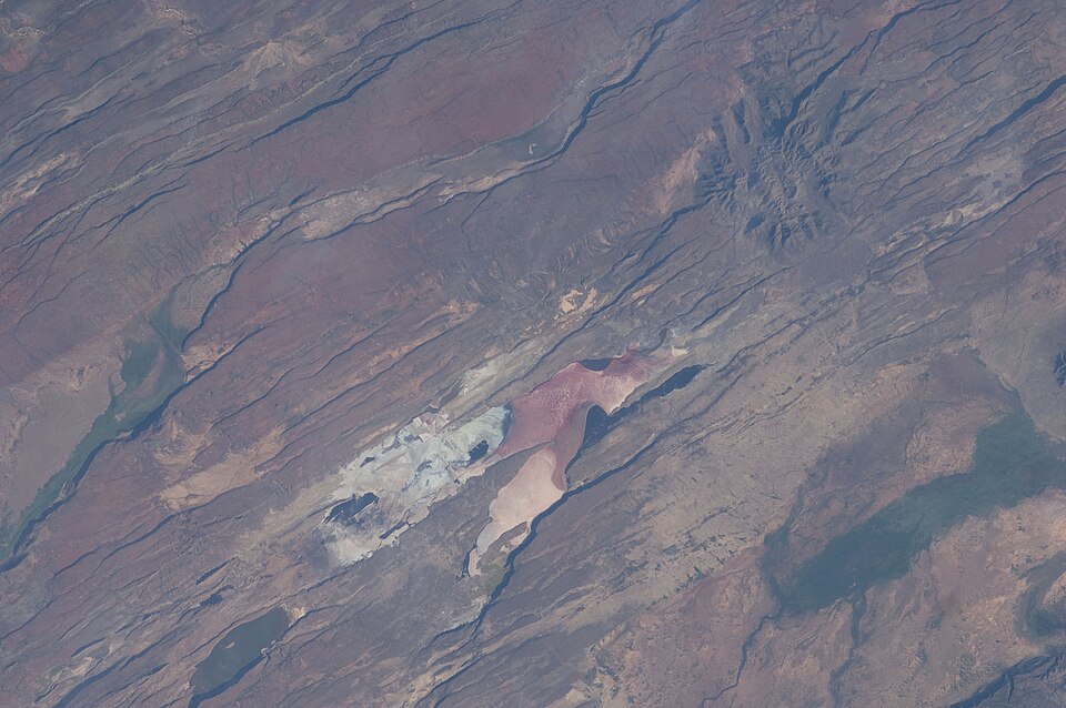
Continental rift zones represent an earlier stage in the divergent boundary process, in which extensional forces have begun to stretch and thin continental lithosphere but have not yet progressed to full rupture and the formation of new oceanic crust. The East African Rift System is the most prominent active example, extending more than 3,000 kilometres from the Afar Triangle in Ethiopia southward through Kenya, Tanzania, and into Mozambique.6 The system records all stages of continental rift evolution along its length: incipient rifting in the south, well-developed graben and half-graben structures in the central segments, and the transition from continental rifting to incipient seafloor spreading in the Afar Depression, where the crust has thinned to less than 25 kilometres and basaltic magmatism dominates.6 If extension continues, the East African Rift will eventually split the African continent in two, creating a new ocean basin in a process analogous to the opening of the Red Sea and the Atlantic Ocean over the past 30 to 180 million years.
Convergent boundaries
Convergent plate boundaries are zones where two plates move toward each other. The geological outcome of convergence depends fundamentally on the nature of the lithosphere involved — whether it is oceanic or continental — because the density contrast between these two types of crust determines whether subduction or collision will occur.17, 18
Oceanic-oceanic convergence occurs where two plates bearing oceanic crust converge, and the older, colder, and therefore denser plate descends beneath the younger one in a process called subduction. The subducting slab generates a deep oceanic trench at the surface and, as it descends to depths of approximately 100 to 150 kilometres, releases water from hydrous minerals into the overlying mantle wedge, triggering partial melting that produces basaltic to andesitic magma.22 This magma ascends through the overriding oceanic plate and erupts to build a curving chain of volcanic islands called an island arc. The Mariana Islands, the Aleutian Islands, the Tonga-Kermadec arc, and the Lesser Antilles are all island arcs formed at oceanic-oceanic convergent boundaries.17, 22
Oceanic-continental convergence occurs where oceanic lithosphere subducts beneath a continental plate. Because continental crust is too buoyant to subduct, the denser oceanic plate invariably descends. The resulting geological features are similar to those of oceanic-oceanic convergence — a trench, a zone of inclined seismicity, and arc magmatism — but the volcanic arc is built on continental crust rather than oceanic crust, forming a continental volcanic arc. The Andes of South America, the longest continental mountain chain on Earth, are the product of the subduction of the Nazca Plate beneath the South American Plate and exemplify this boundary type, with active volcanism, intense seismicity, and a deep trench (the Peru-Chile Trench) paralleling the coast.7, 22 The Cascade Range of the Pacific Northwest, where the Juan de Fuca Plate subducts beneath North America, is another well-studied continental volcanic arc.
Continental-continental convergence produces a fundamentally different outcome. When an ocean basin closes completely through subduction and two continental plates collide, neither plate can subduct because both are composed of low-density silicic crust that is too buoyant to descend into the mantle. Instead, the crust is shortened, thickened, and uplifted into massive fold-and-thrust mountain belts called orogens.7 The Himalaya, the highest mountain range on Earth, is the product of the ongoing collision between the Indian and Eurasian plates, which began approximately 50 to 55 million years ago. Molnar and Tapponnier demonstrated in 1975 that the effects of this collision extend far beyond the Himalaya proper, driving the lateral extrusion of large crustal blocks in Southeast Asia, the uplift of the Tibetan Plateau to an average elevation exceeding 5,000 metres, and the reactivation of faults thousands of kilometres from the collision front.7 The collision has consumed more than 2,500 kilometres of convergence, accommodated by a combination of crustal thickening, underthrusting of the Indian plate beneath Tibet, and lateral escape of material to the east and west.7
Transform boundaries
Transform plate boundaries are zones where two plates slide horizontally past each other, neither creating nor destroying lithosphere. The concept was introduced by Wilson in 1965, who recognised that the fracture zones offsetting mid-ocean ridges were not simple transcurrent faults but a fundamentally new class of fault in which the sense of slip is opposite to the apparent offset of the ridge segments.1 Wilson's insight was critical to the development of plate tectonic theory because it demonstrated that the mid-ocean ridge system could be understood as a coherent global structure segmented by transform faults, rather than as a series of disconnected spreading centres.
.jpg)
Most transform faults are oceanic, linking offset segments of mid-ocean ridges. These are typically short (tens to hundreds of kilometres) and accommodate the differential motion between adjacent segments of the ridge system. Seismicity on oceanic transform faults is confined to the active segment between the two ridge offsets and is characteristically shallow, with earthquakes rarely exceeding 20 kilometres in depth.21 A notable feature of oceanic transforms is their seismic deficit: the cumulative seismic moment released by earthquakes on many oceanic transforms accounts for a relatively small fraction of the total slip predicted by plate motion models, indicating that a substantial proportion of the displacement is accommodated aseismically through creep.21
Continental transform boundaries are less common but far more consequential for human populations. The San Andreas Fault in California is the most studied continental transform on Earth, accommodating approximately 35 millimetres per year of right-lateral motion between the Pacific and North American plates along a fault system roughly 1,200 kilometres long.2 The fault formed approximately 30 million years ago when the Pacific-Farallon spreading ridge began to be subducted beneath the North American plate, progressively replacing the former convergent boundary with a transform boundary as the ridge segments were consumed.1, 18 The Alpine Fault of New Zealand's South Island is a transpressional transform boundary that accommodates roughly 27 millimetres per year of oblique right-lateral slip between the Pacific and Australian plates, combining strike-slip motion with a component of convergence that has uplifted the Southern Alps.16 The Dead Sea Transform is a left-lateral fault system extending approximately 1,000 kilometres from the spreading centre in the Red Sea northward to the Taurus-Zagros collision zone in southern Turkey, accommodating roughly 5 millimetres per year of relative motion between the African (Sinai) and Arabian plates and producing the pull-apart basins of the Dead Sea and the Sea of Galilee along its length.15
Seismicity and volcanism at plate boundaries
The global distribution of earthquakes and volcanic eruptions is overwhelmingly concentrated along plate boundaries, a pattern that provided some of the earliest evidence for the plate tectonic theory itself. Approximately 90 percent of the world's earthquakes and 75 percent of its active volcanoes occur along the circum-Pacific belt, often called the Ring of Fire, a nearly continuous chain of convergent and transform boundaries encircling the Pacific Ocean.8, 17 The seismic and volcanic character of each boundary type is distinct and diagnostic.
At divergent boundaries, seismicity is shallow (typically less than 30 kilometres depth), low to moderate in magnitude, and distributed along the rift axis. Volcanism is predominantly basaltic, driven by decompression melting of the ascending asthenosphere, and produces pillow lavas and sheet flows on the ocean floor. Continental rifts also exhibit shallow seismicity and basaltic to silicic volcanism, though the larger crustal thickness and compositional heterogeneity of continental lithosphere can produce a wider range of magma types and more explosive eruptions.6, 17
At convergent boundaries, seismicity is the most intense and spans the widest depth range of any boundary type. Shallow thrust earthquakes on the subduction interface produce the most powerful seismic events on Earth, including all recorded magnitude 9+ earthquakes. Intermediate and deep earthquakes trace the descending slab to depths of 660 kilometres along the Wadati-Benioff zone. Volcanism at convergent boundaries is characteristically andesitic, explosive, and associated with the formation of stratovolcanoes.17, 22
At transform boundaries, seismicity is shallow and strike-slip in mechanism, and volcanism is generally absent because there is neither the extensional decompression that drives melting at divergent boundaries nor the volatile flux that triggers melting at convergent boundaries.1, 21 Transform earthquakes can nonetheless be highly destructive when they occur beneath populated continental areas, as demonstrated by the 1906 San Francisco earthquake and the 2010 Haiti earthquake.
Characteristics of the three fundamental plate boundary types2, 8, 17
| Characteristic | Divergent | Convergent | Transform |
|---|---|---|---|
| Relative motion | Plates move apart | Plates move together | Plates slide past |
| Lithosphere | Created | Destroyed or shortened | Conserved |
| Earthquake depth | Shallow (<30 km) | Shallow to deep (0–660 km) | Shallow (<20 km) |
| Max earthquake magnitude | ~7 | 9.5 | ~8.5 |
| Volcanism | Basaltic, effusive | Andesitic, explosive | Generally absent |
| Topographic expression | Ridges, rift valleys | Trenches, volcanic arcs, fold mountains | Fault scarps, offset features |
| Example | Mid-Atlantic Ridge | Peru-Chile Trench | San Andreas Fault |
Plate-driving forces
The motion of tectonic plates is driven by a combination of forces arising from the gravitational instability of the lithosphere and the convective flow of the underlying mantle. The relative importance of these forces has been debated since the earliest formulations of plate tectonic theory, but a broad consensus has emerged from quantitative analyses that began with the landmark study of Forsyth and Uyeda in 1975.3
Slab pull is the gravitational force exerted by the cold, dense subducting slab as it sinks into the mantle at convergent boundaries. Because the subducting lithosphere is denser than the surrounding asthenosphere, gravity pulls the slab downward, dragging the trailing plate behind it. Forsyth and Uyeda demonstrated that slab pull is the single most important force driving plate motion, showing that plates attached to large subducting slabs (the Pacific, Nazca, Cocos, and Philippine Sea plates) move significantly faster — at 5 to 10 centimetres per year — than plates without subduction zones (the African, Antarctic, and Eurasian plates), which move at only 1 to 3 centimetres per year.3, 2
Ridge push is the gravitational force arising from the elevated topography of mid-ocean ridges. Because the ridge stands several kilometres above the surrounding abyssal plains, the lithosphere at the ridge axis exerts a lateral push on the adjacent plate, driving it away from the ridge. Although ridge push contributes to plate motion, its magnitude is approximately an order of magnitude less than slab pull.3, 19
Mantle drag, or basal traction, is the force exerted on the base of the lithosphere by the convective flow of the asthenosphere. The role of mantle drag is complex: it can either drive or resist plate motion depending on whether the mantle flow beneath a plate is in the same or opposite direction as the plate's motion. Conrad and Lithgow-Bertelloni showed in 2002 that the mantle flow driven by sinking slabs (termed slab suction) exerts a significant tractive force on both the subducting and overriding plates, and that the combination of direct slab pull and slab-induced mantle suction accounts for virtually all the driving force on Earth's plates.4
The Wilson cycle
Plate boundaries are not permanent features of the Earth's surface. Over geological time, boundaries evolve, migrate, and transform from one type to another as ocean basins open, widen, contract, and close. This cyclical process was first recognised by J. Tuzo Wilson, who in 1966 proposed that the Atlantic Ocean had closed in the Paleozoic to form the Caledonian and Appalachian mountain belts and then re-opened along approximately the same line of weakness to create the modern Atlantic.12 The concept was later formalised and named the Wilson cycle by Dewey and Burke in 1974.13
The Wilson cycle is conventionally described in six stages. In the embryonic stage, a continental plate is stretched by extensional forces, producing a rift valley similar to the present-day East African Rift. In the juvenile stage, rifting proceeds to the point of continental breakup and the formation of a narrow, incipient ocean basin, as exemplified by the modern Red Sea. In the mature stage, seafloor spreading has created a wide ocean basin flanked by passive continental margins, as in the present-day Atlantic Ocean. In the declining stage, subduction initiates at one or both margins of the ocean basin, and the ocean begins to close. In the terminal stage, the ocean basin narrows to a remnant seaway, as in the modern Mediterranean. Finally, in the suture stage, the ocean closes completely and the two continental masses collide, forming a mountain belt and a suture zone that preserves fragments of the former ocean floor as ophiolites.12, 14
The Wilson cycle thus describes the long-term transition from divergent to convergent boundary conditions at a given location, and its repeated operation over Earth history has assembled and fragmented supercontinents including Rodinia, Gondwana, and Pangaea. The recognition that the same crustal zones have been repeatedly exploited by successive Wilson cycles — a phenomenon called tectonic inheritance — underscores the profound influence of pre-existing structures on the location and character of plate boundaries.14
Triple junctions
A triple junction is a point where three tectonic plates, and therefore three plate boundaries, meet. The kinematics and stability of triple junctions were first analysed systematically by McKenzie and Morgan in 1969, who demonstrated that the relative velocities of the three plates at a triple junction must form a closed velocity triangle — that is, the three relative velocity vectors must sum to zero.9 This geometric constraint means that not all combinations of boundary types can form stable triple junctions; McKenzie and Morgan identified 16 possible geometric configurations, of which only certain combinations are kinematically stable over time.9
The most common stable configuration is the ridge-ridge-ridge (RRR) triple junction, which is always stable regardless of the relative plate velocities. The Afar Triple Junction in the Horn of Africa is one of the few emerged examples of an RRR triple junction, where the divergent boundaries of the Red Sea rift, the Gulf of Aden rift, and the East African Rift meet in the Afar Depression of Ethiopia.20 This junction marks the point at which the Arabian, Nubian, and Somali plates are all diverging from one another, and the Afar Depression preserves a unique geological record of the transition from continental rifting to oceanic spreading in all three arms of the junction.6, 20
Other notable triple junctions include the Mendocino Triple Junction off the coast of northern California, where the Pacific, North American, and Juan de Fuca (Gorda) plates meet at a configuration involving the San Andreas transform, the Cascadia subduction zone, and the Gorda Ridge spreading centre. The Azores Triple Junction in the central North Atlantic marks the intersection of the Eurasian, African, and North American plates.8, 9 Triple junctions are not merely geometric curiosities; they are dynamic features that migrate over time as the plates evolve, and their migration can fundamentally reorganise the tectonic regime of an entire region, as the northward migration of the Mendocino Triple Junction has progressively converted the western margin of North America from a convergent to a transform boundary over the past 30 million years.1, 9
Diffuse plate boundaries
The classical plate tectonic model assumes that lithospheric plates behave as rigid bodies and that deformation is concentrated along narrow plate boundaries. While this approximation works remarkably well for most of the ocean basins, it breaks down in several regions where deformation is distributed over zones hundreds or even thousands of kilometres wide. These diffuse plate boundaries represent a significant departure from the idealised rigid-plate model and cover approximately 15 percent of Earth's surface.11
The most extensively studied diffuse plate boundary is the Indian Ocean deformation zone. Royer and Gordon demonstrated in 1997 that the traditionally defined Indo-Australian plate is not a single rigid plate but consists of at least three distinct component plates — the Indian (Capricorn), Australian, and Somalian plates — separated by diffuse boundaries accommodating relative motions of 2 to 16 millimetres per year.10 The boundary between the Indian and Australian components extends across a broad zone of the central Indian Ocean, where distributed compressional deformation produces long-wavelength folding of the oceanic lithosphere, widespread intraplate seismicity, and reactivation of pre-existing fracture zone faults. This deformation zone, which stretches for nearly 2,000 kilometres, is one of the most seismically active intraplate regions on Earth and challenges the simplifying assumption of plate rigidity that underlies classical plate tectonic theory.10, 11
Diffuse boundaries also occur within continental lithosphere, where the mechanical weakness and heterogeneity of the crust allow deformation to spread over wide areas. The broad zone of deformation in western North America between the Pacific and North American plates, encompassing the Basin and Range Province and the Walker Lane-Eastern California Shear Zone, is an example of a diffuse continental boundary in which a significant fraction of the relative plate motion is accommodated by distributed faulting far from the San Andreas Fault proper.8, 11 Gordon's 1998 review concluded that the recognition of diffuse boundaries does not invalidate the plate tectonic paradigm but rather reveals it as an approximation — an extraordinarily useful one, but one that must be supplemented by models of distributed deformation in regions where the rigid-plate assumption fails.11
Plate boundaries and geological hazards
The concentration of tectonic activity at plate boundaries has direct and profound consequences for the distribution of geological hazards, including earthquakes, volcanic eruptions, tsunamis, and landslides. The type of plate boundary exerts a first-order control on the nature, severity, and recurrence interval of these hazards.8, 17

Convergent boundaries are the most hazardous. Subduction zone megathrust faults produce the largest earthquakes on Earth, with rupture areas spanning hundreds of thousands of square kilometres and moment magnitudes reaching 9.5. The vertical displacement of the seafloor during these events generates transoceanic tsunamis capable of devastating coastlines thousands of kilometres from the earthquake source, as demonstrated by the 2004 Indian Ocean tsunami and the 2011 Tohoku tsunami.17 Continental collision zones produce intense and damaging seismicity distributed over broad areas; the Himalayan collision zone generates major earthquakes that threaten some of the most densely populated regions on Earth, including the Indo-Gangetic Plain.7 Volcanic hazards at convergent boundaries include pyroclastic flows, lahars, ashfall, and volcanic gases, all of which are associated with the explosive stratovolcanoes characteristic of subduction-related arc systems.22
Transform boundaries present significant seismic hazards, particularly where they traverse densely populated continental regions. The San Andreas Fault system poses a major earthquake risk to the population centres of California, and the North Anatolian Fault in Turkey has produced a devastating westward-migrating sequence of large earthquakes over the past century.2 Although transform boundaries generally lack volcanism, their shallow, strike-slip earthquakes can produce intense ground shaking in the near field, and the absence of a deep-water trigger means that tsunami hazard is typically low compared to convergent boundaries.21
Divergent boundaries in oceanic settings pose relatively low direct hazard to human populations because they are largely submarine. However, continental rift zones such as the East African Rift are associated with significant seismic and volcanic hazards, including moderate to large earthquakes, basaltic to silicic eruptions, and the release of toxic volcanic gases from rift-associated lakes, as tragically demonstrated by the 1986 Lake Nyos disaster in Cameroon.6 Understanding the relationship between plate boundary type and hazard character is fundamental to seismic risk assessment and disaster preparedness for the billions of people who live within the influence of active plate margins.
References
The plate tectonic approximation: plate nonrigidity, diffuse plate boundaries, and global plate reconstructions
Internal structure of the Dead Sea leaky transform (rift) in relation to plate kinematics
Quaternary slip rate and geomorphology of the Alpine fault: implications for kinematics and seismic hazard in southwest New Zealand