Overview
- Karst landscapes form through the chemical dissolution of soluble bedrock — primarily limestone, dolomite, and evaporites — by carbonic acid in percolating water, producing a distinctive suite of landforms including sinkholes, caves, tower karst, and underground drainage networks that cover approximately 15% of Earth's ice-free continental surface.
- Cave passages typically require 10,000 to 100,000 years to reach traversable size, with wall retreat rates of 0.01–0.1 cm per year governed by CO₂–H₂O–CaCO₃ dissolution kinetics, while surface denudation rates in temperate karst average 20–100 mm per thousand years and can exceed 200 mm per thousand years in wet tropical regions.
- Karst aquifers supply drinking water to roughly 25% of the global population, yet their high permeability and lack of natural filtration make them exceptionally vulnerable to contamination, while carbonate weathering in karst terrains contributes a disproportionate share of the global carbon flux from continental chemical weathering.
Karst geomorphology is the study of landforms and processes that arise from the chemical dissolution of soluble bedrock, principally limestone (CaCO₃), dolomite (CaMg(CO₃)₂), and evaporites such as gypsum and halite. The term “karst” derives from the Kras plateau on the border of Slovenia and Italy, where the distinctive landscape of bare rock, enclosed depressions, sinking streams, and caves was first described scientifically in the nineteenth century.1, 9 Karst terrains are characterised by a set of features found in no other geomorphic environment: internal drainage through sinkholes and shafts, extensive cave systems that can extend for hundreds of kilometres, and springs that discharge groundwater at rates rivalling surface rivers.1, 2
Carbonate and evaporite rocks susceptible to karstification cover approximately 15.2% of the global ice-free continental surface, an area of roughly 22 million square kilometres.6, 14 These terrains are found on every continent and in every climatic zone, from the permafrost karst of northern Canada and Siberia to the spectacularly sculpted tower karst of southern China and Southeast Asia.1, 13 Karst aquifers supply drinking water to an estimated 25% of the world’s population, making the understanding of karst processes essential not only to geomorphology but also to hydrogeology, civil engineering, and environmental management.6, 14
Dissolution chemistry and kinetics
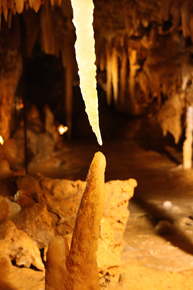
The fundamental process that creates karst landscapes is the dissolution of carbonate minerals by naturally acidic water. Rainwater absorbs carbon dioxide from the atmosphere and, more importantly, from soil air where biological respiration can raise CO₂ concentrations to 10–100 times atmospheric levels. The dissolved CO₂ reacts with water to form carbonic acid (H₂CO₃), which attacks carbonate rock according to the net reaction CaCO₃ + H₂O + CO₂ → Ca²⁺ + 2HCO₃⁻.1, 4, 5 This reaction is reversible: when CO₂ degasses from solution — as occurs in cave passages open to the atmosphere — calcite precipitates, forming speleothems such as stalactites and stalagmites.2, 15
The kinetics of calcite dissolution were established quantitatively by Plummer, Wigley, and Parkhurst, whose 1978 rate equation (the PWP model) describes dissolution as a function of the activities of H⁺, H₂CO₃, and H₂O at the mineral surface.4 Dreybrodt extended this work to show that dissolution rates are fast when solutions are far from equilibrium but drop by roughly an order of magnitude as solutions approach 70–90% saturation with respect to calcite, a nonlinear behaviour that has profound implications for cave passage development.5, 17 Because the final approach to equilibrium is slow, thin films of water percolating through fractures can remain aggressive over considerable distances, enabling dissolution to enlarge fractures deep within the rock mass.5 The rate-limiting step in most natural karst systems is not the surface reaction itself but the rate at which CO₂ can be supplied to the dissolving front, making soil CO₂ production — and therefore climate, vegetation, and biological activity — a primary control on karstification rates.1, 12
Evaporite minerals dissolve by a simpler mechanism that does not require carbonic acid. Gypsum (CaSO₄·2H₂O) and halite (NaCl) are orders of magnitude more soluble than calcite, so evaporite karst develops much more rapidly but tends to be less stable, with frequent collapse features and high subsidence rates.1, 7
Surface landforms
The most characteristic surface feature of karst is the sinkhole (doline), an enclosed depression that captures surface runoff and directs it underground. Sinkholes range from shallow dish-shaped depressions a few metres across to steep-walled collapse structures hundreds of metres in diameter.1, 7 Three principal genetic types are recognised: solution sinkholes form by gradual lowering of the bedrock surface along joints and fractures; cover-subsidence sinkholes develop where overlying soil slowly ravels into widened fissures in the rock below; and cover-collapse sinkholes form catastrophically when the roof of a soil arch over a bedrock cavity fails suddenly, producing a steep-sided pit that can appear without warning and swallow roads, buildings, and vehicles.7, 11

Beyond sinkholes, karst surfaces display a hierarchy of dissolutional sculpture. At the smallest scale, karren (also called lapiés) are grooves, rills, and flutes etched into exposed limestone by direct rainfall dissolution, with individual forms ranging from millimetre-scale solution pits to metre-deep rundkarren channels beneath soil cover.1, 13 At the landscape scale, closed depressions grow by coalescence into compound forms: uvalas (formed by the merging of multiple sinkholes) and poljes (large flat-floored depressions, typically kilometres in length, bounded by steep walls and drained internally through ponors at their margins).1, 9 Poljes are especially well developed in the Dinaric karst of Croatia and Bosnia-Herzegovina, where they serve as important agricultural lowlands that are subject to seasonal flooding when discharge through their floor drains cannot keep pace with runoff.1, 13
Caves and underground drainage
Caves are the subsurface expression of karst and represent the conduits through which groundwater flows in soluble rock. Palmer’s classification distinguishes three fundamental cave types based on the recharge and flow conditions that control their morphology: branchwork caves form under concentrated recharge from sinking streams and surface sinkholes, producing dendritic passage networks analogous to surface stream tributaries; network (maze) caves form when many fractures enlarge simultaneously under conditions of diffuse recharge across a wide area, as occurs during periodic flooding; and ramiform caves form by rising (hypogene) water, often enriched in hydrogen sulphide or deep-sourced CO₂, that dissolves rock from below independent of surface hydrology.3, 15
The development of a cave passage from an initial fracture to traversable size follows a well-characterised evolutionary sequence. In the earliest phase, water seeps through a tight fracture (aperture less than about 1 cm) in laminar flow; dissolution is slow and nearly uniform along the flow path because the water remains aggressive throughout.5 As the fracture widens, flow transitions to turbulent, discharge increases nonlinearly, and a positive feedback loop is established in which the most favoured flow path captures an increasing share of the available recharge, accelerating its growth relative to competing fractures.3, 5 This competitive growth process, termed “breakthrough,” typically requires 10,000 to 100,000 years to produce passages of traversable size, with wall retreat rates approaching a maximum of 0.01–0.1 cm per year once turbulent flow is established.3
The depth at which cave passages form is controlled by the position of the water table and the base level set by surface rivers or the sea. Passages that develop at or near the water table tend to be horizontal and follow the hydraulic gradient closely, while those formed in the phreatic zone (below the water table) can loop to considerable depths before rising to springs, creating the phreatic loops that are characteristic of many of the world’s largest cave systems.1, 2 When base level drops due to tectonic uplift or the incision of surface valleys, the active drainage zone shifts downward, abandoning upper-level passages that may be preserved as dry fossil galleries for millions of years.1, 16
Karst hydrology
Groundwater flow in karst differs fundamentally from flow in granular aquifers. In a porous sandstone or gravel aquifer, water moves through innumerable small pore spaces at velocities of metres per day, and Darcy’s law provides a good description of flow behaviour. In a karst aquifer, by contrast, water moves through a hierarchical network of enlarged fractures, bedding planes, and conduits whose apertures can range from sub-millimetre fissures to cave passages tens of metres in diameter.1, 2, 21 Flow velocities in karst conduits routinely reach hundreds of metres per day and can exceed several kilometres per day during storm events, as demonstrated by dye-tracing experiments conducted in karst regions worldwide.1, 21
This triple-porosity structure — matrix, fracture, and conduit — gives karst aquifers their distinctive hydrological behaviour. Base flow is sustained by slow drainage from the rock matrix and smaller fractures, while storm peaks are transmitted rapidly through the conduit network, producing spring hydrographs with sharp flood pulses that can lag rainfall by as little as a few hours.2, 20 The ratio of quick-flow to base-flow discharge provides a measure of aquifer karstification: well-developed conduit systems pass most of their discharge as quick flow, while younger or less-developed karst systems retain a larger diffuse-flow component.1, 21
The rapid transit of water through karst conduits has critical implications for water quality. Unlike granular aquifers, which filter contaminants through their fine pore spaces, karst conduits provide essentially no natural attenuation, so that pollutants introduced at the surface — agricultural chemicals, sewage, petroleum products — can reach springs and wells within hours to days with little dilution or degradation.1, 7, 21 For this reason, groundwater protection in karst regions requires a fundamentally different approach than in other aquifer types, with emphasis on delineating recharge areas, mapping conduit connections by tracer testing, and establishing buffer zones around sinkholes and sinking streams that serve as direct recharge points.21, 20
Climatic controls and tropical karst

_2_(25075689038).jpg)
Climate exerts a powerful control on the rate and style of karstification through its influence on precipitation, temperature, and biological CO₂ production. In cold, dry climates, dissolution rates are low and karst development is limited to shallow surface features and slow-growing cave systems. In temperate humid regions, surface denudation rates typically fall in the range of 20–100 millimetres per thousand years, sufficient to produce mature sinkhole plains and extensive cave networks over Pleistocene timescales.1, 12 In the wet tropics, where rainfall exceeds 2,000 mm per year and soil CO₂ concentrations are elevated by intense biological activity, denudation rates can exceed 200 mm per thousand years, driving the development of the most dramatic karst landscapes on Earth.1, 9, 12
Tropical karst is expressed in two end-member landscape types whose Chinese nomenclature has been adopted internationally. Fengcong (cone or cockpit karst) consists of a continuous terrain of steep-sided conical hills separated by deep closed depressions (cockpits) with no intervening flat ground; all drainage is internal, and the landscape lacks surface streams entirely.10, 13 Fenglin (tower karst) comprises isolated, near-vertical limestone towers rising abruptly from an alluvial plain or a broad river floodplain; the towers are residual remnants of a formerly continuous limestone mass that has been removed by dissolution and lateral planation.10, 19 The classic tower karst of Guilin and Yangshuo in Guangxi province, China, inscribed as a UNESCO World Heritage Site in 2007, represents one of the most spectacular karst landscapes on the planet, with towers up to 100 metres tall rising from a flat rice-paddy plain along the Li River.19
The evolutionary relationship between fengcong and fenglin has been debated since Sweeting’s pioneering work in the 1970s. The prevailing model holds that fengcong develops first in uplifted limestone plateaux with deep water tables, and that fenglin emerges as a later stage when river incision and lateral planation lower the surrounding terrain to expose the bases of the residual towers.9, 10, 13 Other factors, including lithological variations, tectonic fracture density, and the thickness of overlying insoluble caprock, modulate which style of tropical karst develops in a given region.1, 10
Typical karst surface denudation rates by climate zone1, 12
The rate at which a karst surface is lowered by dissolution — the dissolutional denudation rate — integrates the effects of precipitation, temperature, soil CO₂ availability, and rock solubility. Direct measurement of denudation is difficult; estimates are derived from solute loads in karst springs, from micro-erosion meter readings on exposed rock surfaces, and from the depth of cosmogenic nuclide depletion in surface bedrock.12, 16 These methods converge on a global picture in which wet tropical karst dissolves at rates several times faster than temperate karst, which in turn is several times faster than arid or cold-climate karst.1, 12
The maximum rates occur in equatorial regions with high rainfall, dense vegetation, and year-round warmth — conditions that maximise both the volume of aggressive water available and the CO₂ concentration of that water. At the low end, arid and polar karst develops so slowly that many features visible today are relict from earlier, wetter climate phases rather than products of ongoing dissolution.1, 13
Karst and the carbon cycle
Carbonate dissolution and precipitation in karst systems play a significant role in the global carbon cycle. The dissolution reaction CaCO₃ + CO₂ + H₂O → Ca²⁺ + 2HCO₃⁻ consumes one mole of atmospheric (or soil) CO₂ for every mole of carbonate dissolved, transferring carbon from the atmosphere into the dissolved bicarbonate pool of rivers and groundwater.8, 18 Liu and Zhao estimated that global carbonate weathering consumes approximately 0.477 gigatonnes of atmospheric carbon per year, a flux comparable in magnitude to the net carbon uptake by the world’s forests.8
The significance of this flux for long-term climate is debated, however, because carbonate weathering is not a permanent carbon sink on geological timescales. When the dissolved Ca²⁺ and HCO₃⁻ are eventually transported to the ocean and reprecipitated as marine carbonate sediment, half of the originally consumed CO₂ is released back to the atmosphere, yielding a net uptake of only 0.5 moles of CO₂ per mole of carbonate cycled.1, 18 Silicate weathering, by contrast, provides a more permanent sink because no CO₂ is returned upon marine carbonate precipitation. Nevertheless, carbonate weathering responds more rapidly to changes in climate and land use than silicate weathering, making it an important component of the short-term (10²–10⁴ year) carbon budget.8, 18
Karst systems also store and release carbon through biological processes in caves and soils. Cave-stream organic carbon fluxes, CO₂ degassing at cave entrances and springs, and the sequestration of carbon in speleothem calcite all contribute to the net carbon balance of karst landscapes.1, 20 Recent research suggests that biological uptake of CO₂ in karst aquatic ecosystems — by aquatic photosynthesis converting dissolved CO₂ back into organic carbon — may enhance the net carbon sink beyond what purely abiotic weathering models predict, although the magnitude of this biological pump remains poorly constrained at the global scale.8, 20
Engineering hazards and human impacts
Karst terrains present a distinctive suite of engineering challenges. Cover-collapse sinkholes can form suddenly and without obvious precursor deformation, creating catastrophic hazards for buildings, roads, and infrastructure. In the United States alone, karst-related damage — principally from sinkhole subsidence — is estimated to cost hundreds of millions of dollars per year, with Florida, Texas, Alabama, Missouri, and Pennsylvania among the most severely affected states.7, 11 Human activities frequently accelerate sinkhole formation: the lowering of water tables by pumping removes the buoyant support that stabilises soil arches over bedrock cavities, while construction vibration, altered drainage patterns, and the concentration of stormwater runoff into the ground can trigger collapses that would not have occurred under natural conditions.7, 11
Groundwater contamination in karst is an equally pressing concern. Because karst aquifers lack the natural filtration provided by granular pore spaces, contaminants can travel from the surface to a drinking-water spring in hours or days, bypassing the attenuation mechanisms that protect other aquifer types.1, 21 Karst springs have been documented to transmit agricultural nitrate and pesticides, faecal bacteria from septic systems and livestock operations, and industrial solvents from spills and leaking storage tanks, often at concentrations exceeding drinking-water standards.21, 20 Effective protection of karst water resources requires detailed mapping of the conduit network by dye-tracing, delineation of recharge-area boundaries, and land-use controls that prevent direct introduction of contaminants into sinkholes and sinking streams.21
Construction in karst also requires specialised site investigation. Standard geotechnical borings may miss voids and irregular rockhead topography because the pinnacled surface of karstified limestone can vary by metres or tens of metres over short horizontal distances. Ground-penetrating radar, microgravity surveys, and electrical resistivity tomography are commonly employed alongside drilling to detect subsurface cavities and assess the stability of the rock mass before foundation design proceeds.7, 20
Global distribution and significance
The World Karst Aquifer Mapping project (WOKAM), completed in 2017 under the auspices of UNESCO and the International Association of Hydrogeologists, produced the first comprehensive global map of carbonate and evaporite outcrops and their associated aquifers.6, 14 The map shows that karstifiable rocks cover approximately 15.2% of the global ice-free land surface, with the largest contiguous exposures in the Mediterranean basin, the Middle East, southeastern China, the Caribbean, and the Interior Low Plateaus and Appalachian region of the eastern United States.14 Approximately 25% of the world’s population obtains its drinking water wholly or partly from karst aquifers, a proportion that rises to roughly 40% across much of southern Europe and the Caribbean islands.6, 14
Karst landscapes also possess extraordinary biodiversity and cultural value. Caves harbour highly specialised fauna — troglobites — that have evolved in isolation over millions of years and are found nowhere else; many karst regions are recognised biodiversity hotspots for endemic invertebrates, amphibians, and fish.13 Caves have served as human habitation sites, ceremonial spaces, and repositories of rock art for at least 40,000 years, and the sediment and speleothem sequences they preserve provide some of the most detailed palaeoclimate and palaeoenvironmental archives available to science.1, 13 The South China Karst, the Dinaric karst of the western Balkans, and the Carlsbad Caverns and Mammoth Cave regions of the United States are among the many karst areas inscribed on the UNESCO World Heritage List in recognition of their outstanding universal value.19
References
The kinetics of calcite dissolution in CO₂–water systems at 5–60 °C and 0.0–1.0 atm CO₂
Differentiating tower karst (fenglin) and cockpit karst (fengcong) using DEM contour, slope, and centroid
On concepts and methods for the estimation of dissolutional denudation rates in karst areas
Cave geology and speleogenesis over the past 65 years: role of the National Speleological Society in advancing the science
Global silicate weathering and CO₂ consumption rates deduced from the chemistry of large rivers