Overview
- The Mohorovičić discontinuity, or Moho, is the boundary between Earth's crust and mantle, defined by an abrupt increase in seismic wave velocity discovered by Croatian seismologist Andrija Mohorovičić in 1909 after analysing the Pokuplje earthquake.
- The Moho lies at depths of 5–10 kilometres beneath the ocean floor but 30–70 kilometres beneath the continents, marking a compositional transition from silicate-rich crustal rocks to the denser, magnesium-iron-rich peridotite of the upper mantle.
- Despite ambitious drilling projects including Project Mohole in the 1960s and modern efforts at ultradeep ocean drilling, no borehole has yet penetrated the Moho in situ, and our understanding of this boundary relies overwhelmingly on seismic imaging and studies of exposed mantle sections called ophiolites.
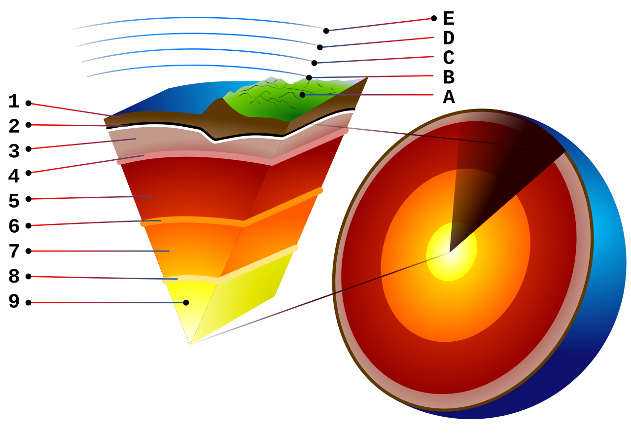
The Mohorovičić discontinuity — universally abbreviated as the Moho — is the boundary between Earth's crust and the underlying mantle. It is defined by a sharp increase in the velocity of compressional seismic waves (P-waves) from roughly 6.5–7.2 kilometres per second in the lower crust to approximately 7.6–8.2 kilometres per second in the uppermost mantle, a jump that reflects a fundamental change in rock composition.1, 7 Discovered in 1909 by the Croatian geophysicist and meteorologist Andrija Mohorovičić through careful analysis of seismograms from a nearby earthquake, the Moho was the first major internal boundary of Earth to be identified seismologically and remains one of the most important structural features in solid-earth geophysics. It encircles the entire planet, though its depth varies enormously — from as little as 5 kilometres beneath some oceanic spreading centres to more than 70 kilometres beneath the thickest continental mountain belts.5, 6
Andrija Mohorovičić and the 1909 Pokuplje earthquake
On 8 October 1909, an earthquake of moderate magnitude struck the Pokuplje region approximately 40 kilometres south of Zagreb in Croatia (then part of the Austro-Hungarian Empire). Andrija Mohorovičić, director of the Meteorological Observatory in Zagreb and an accomplished seismologist, collected seismograms from stations across the region and noticed a perplexing feature in the arrival times of the P-waves.1, 17 At nearby stations, the first arrivals corresponded to waves that had travelled directly through the crust. But beyond a certain distance — roughly 200 kilometres from the epicentre — a second, earlier-arriving P-wave phase appeared, one that had clearly taken a faster path. Mohorovičić deduced that this faster wave had descended to a deeper layer of higher velocity, refracted along it, and returned to the surface ahead of the direct crustal wave. By applying the principles of geometric ray theory to his observations, he calculated that the boundary between the slower upper layer (the crust) and the faster lower layer (what would later be called the mantle) lay at a depth of approximately 54 kilometres beneath the Croatian Dinarides.1
Mohorovičić published his analysis in 1910 as a detailed monograph in the yearbook of the Zagreb observatory. His work was rigorous, including travel-time curves, ray-path diagrams, and calculations of the velocity contrast across the boundary.1 The significance of his discovery was immediately appreciated by the international seismological community. Beno Gutenberg, who would later become one of the most influential seismologists of the twentieth century, confirmed and refined Mohorovičić's findings using earthquake data from other regions, establishing that the velocity discontinuity was a global feature of the planet rather than a local Croatian anomaly.2 The boundary came to bear Mohorovičić's name, and the informal contraction "Moho" entered the geological vocabulary as one of its most recognisable terms.
Mohorovičić's achievement was grounded in the broader development of seismology in the late nineteenth and early twentieth centuries. By the time of the 1909 earthquake, the travel-time behaviour of seismic waves through a layered medium was well understood from the work of physicists such as Lord Rayleigh and Augustus Love, and seismographic networks had been installed across Europe and Japan. What distinguished Mohorovičić's contribution was the clarity with which he identified the specific depth and velocity contrast of a boundary that had not previously been recognised, transforming the abstract concept of a layered Earth into a quantitative geophysical reality.17
The seismic velocity jump and its physical meaning
The Moho is fundamentally a seismological boundary — it is defined by a change in the speed at which elastic waves propagate through rock. In the lower continental crust, P-wave velocities typically range from 6.5 to 7.2 kilometres per second, while immediately below the Moho, in the uppermost mantle, they increase to 7.6–8.2 kilometres per second.6, 7 Shear waves (S-waves) show a comparable jump, from roughly 3.5–3.9 kilometres per second above the boundary to 4.4–4.7 kilometres per second below. This velocity increase is not gradual but occurs over a vertical interval of at most a few hundred metres, and in many locations appears essentially instantaneous at the resolution of seismic observations.7
Seismic wave velocities in rock are controlled principally by two properties: the elastic moduli (the stiffness of the material) and its density. A denser rock transmits waves more slowly, all else being equal, but a stiffer rock transmits them faster. The mantle is both denser and stiffer than the crust, but the increase in stiffness more than compensates for the increase in density, producing a net velocity increase.13 The velocity jump at the Moho therefore records a change in bulk composition and mineralogy. The lower crust, particularly beneath the oceans, is composed predominantly of gabbroic rocks — coarse-grained equivalents of basalt, rich in plagioclase feldspar and pyroxene. The uppermost mantle, by contrast, is dominated by peridotite, an ultramafic rock composed primarily of the mineral olivine with lesser amounts of pyroxene and garnet.12, 13
The sharpness of the Moho has been a subject of sustained investigation. In many continental settings, particularly beneath stable Precambrian shields, the Moho is a remarkably sharp interface, with the velocity transition occurring over less than one kilometre. In other settings — notably beneath active volcanic arcs and some collisional mountain belts — the transition is broader and more gradational, suggesting the presence of a transition zone in which crustal and mantle rocks are interleaved through magmatic underplating, phase changes, or tectonic interleaving.7, 4 The distinction between a sharp compositional Moho and a more gradational seismic Moho is geophysically important: the seismological boundary is defined purely by velocity, while the petrological boundary (the change from crustal to mantle rocks) may not coincide precisely in depth.
Depth variations: oceans, continents, and mountains
One of the most significant characteristics of the Moho is its highly variable depth, which mirrors the fundamental structural difference between oceanic and continental crust. Global compilations of seismic data, including the widely used CRUST1.0 model, have mapped the Moho depth across the entire planet at a resolution of one degree.5
Beneath the oceans, the Moho is comparatively shallow. Normal oceanic crust, produced at mid-ocean ridges by partial melting of the mantle, is remarkably uniform in thickness at approximately 6–7 kilometres, so the Moho typically lies 7–12 kilometres below sea level when the water column is included.6, 15 At fast-spreading ridges such as the East Pacific Rise, the crust may thin to as little as 5 kilometres at the ridge axis itself, placing the Moho correspondingly closer to the seafloor. At oceanic plateaus such as the Ontong Java Plateau in the western Pacific, the crust thickens to 30 kilometres or more due to voluminous magmatic additions, and the Moho deepens accordingly.6
Continental crust is much thicker and far more variable. Average continental crustal thickness is approximately 35 kilometres, but the range extends from around 25 kilometres beneath some rifted margins and extended terranes to more than 70 kilometres beneath the Tibetan Plateau and the central Andes — the two highest-standing continental regions on Earth.5, 6 This thickening reflects the principle of isostasy: high-standing topography is supported by a deep crustal root that displaces denser mantle material, much as the submerged portion of an iceberg supports the visible portion above water. The Moho beneath the Himalayas has been imaged at depths exceeding 70 kilometres, representing the deepest point of the crust-mantle boundary anywhere on the planet.4
Moho depth beneath representative geological settings5, 6
| Setting | Typical Moho depth (km) | Crustal thickness (km) |
|---|---|---|
| Normal oceanic crust | 7–12 below sea level | 6–7 |
| Mid-ocean ridge axis | 5–8 below sea level | 3–6 |
| Oceanic plateau | 15–35 below sea level | 15–30 |
| Continental shelf | 25–35 | 25–35 |
| Stable continental interior | 35–45 | 35–45 |
| Active rift zone | 20–30 | 20–30 |
| Collisional orogen (Alps) | 40–55 | 40–55 |
| Tibetan Plateau / Himalayas | 65–75 | 65–75 |
The transition from thin oceanic crust to thick continental crust at passive continental margins occurs over a zone typically 100–200 kilometres wide, across which the Moho deepens progressively from its oceanic to its continental depth. This transition zone is of considerable interest to petroleum geology because the stretching and thinning of continental crust during rifting creates sedimentary basins that often contain significant hydrocarbon reserves.4
Compositional change across the boundary
The velocity jump at the Moho records a fundamental change in rock type. Earth's crust is broadly divided into two compositional categories. Oceanic crust is formed by the partial melting of mantle peridotite at mid-ocean ridges and is overwhelmingly basaltic in composition — a layered sequence comprising, from top to bottom, pillow basalts, sheeted dykes, and coarse-grained gabbro.10, 15 Continental crust is more compositionally diverse and, on average, more silica-rich: its upper portion is broadly granodioritic (intermediate in composition between granite and basalt), while its lower portion is more mafic, grading toward gabbro and granulite-facies metamorphic rocks.12
Below the Moho, the uppermost mantle is composed of peridotite — specifically, harzburgite and lherzolite, which are ultramafic rocks dominated by the mineral olivine (typically 60–80 per cent by volume) with subordinate orthopyroxene, clinopyroxene, and, at greater depths, garnet.13 The transition from gabbroic lower crust to peridotitic upper mantle involves a dramatic decrease in silica content (from approximately 48–52 weight per cent in gabbro to 43–46 weight per cent in peridotite) and corresponding increases in magnesium and iron. This compositional change is the primary cause of the seismic velocity increase at the Moho: the olivine-dominated mantle assemblage is significantly stiffer and denser than the feldspar-pyroxene assemblage of the lower crust.7, 13
Direct samples of rocks from the Moho transition are rare but not unknown. Ophiolites — fragments of oceanic crust and upper mantle that have been tectonically emplaced onto continental margins during collisional events — provide the most complete cross-sections through the crust-mantle boundary available for direct study. The Oman (Samail) ophiolite, the largest and best-preserved ophiolite on Earth, exposes a complete sequence from pillow lavas through sheeted dykes and gabbros down to the mantle transition zone, where layered gabbros give way to harzburgite over a remarkably narrow interval.10 Studies of this transition in Oman and other ophiolites have confirmed the seismologically inferred compositional change and have revealed additional complexity, including zones of dunite (pure olivine rock) at the base of the crust that may represent conduits of focused melt transport through the uppermost mantle.
In some tectonic settings, the seismic Moho may not coincide with the petrological Moho. Where the lower crust has been underplated by mafic magma — as occurs beneath active volcanic arcs and flood basalt provinces — bodies of high-velocity gabbroic or pyroxenitic material may lie at depths traditionally associated with the mantle, blurring the seismic distinction between crust and mantle. Conversely, serpentinisation of mantle peridotite (the hydration of olivine to form the low-density mineral serpentine) can reduce mantle velocities to values approaching those of the lower crust, effectively erasing the Moho seismically even where a compositional boundary persists.7, 16
Project Mohole and the quest to drill through the crust
The existence of the Moho as a clearly defined seismic boundary naturally raised the question of whether it could be reached by drilling. In 1957, a group of American geoscientists affiliated with the American Miscellaneous Society — an informal scientific club — proposed what became known as Project Mohole: an attempt to drill through the oceanic crust into the upper mantle, recovering continuous core samples across the Moho for the first time.8 The choice of oceanic rather than continental crust was pragmatic: with only 5–7 kilometres of rock to penetrate (compared to 35 or more kilometres on land), the ocean floor offered a vastly shorter path to the mantle, despite the engineering challenge of drilling in deep water.
The project's initial phase, conducted in 1961 off the coast of Guadalupe Island, Mexico, was a technical triumph. Using the barge CUSS I, the drilling team successfully penetrated 183 metres into the seafloor beneath 3,566 metres of water — the first time a hole had been drilled in the deep ocean floor. The cores recovered included basalt overlain by Miocene sediment, confirming the volcanic nature of the oceanic crust and demonstrating that deep-ocean drilling was technically feasible.8 The scientific community was electrified by the results.
The project's subsequent history was less triumphant. As the programme expanded in scope and cost, it became entangled in bureaucratic disputes, contractor conflicts, and escalating budgets. The engineering challenges of drilling to Moho depth — maintaining a stable borehole in fractured, hot rock while compensating for ship motion in open ocean — proved far greater than the initial test had suggested. In 1966, the United States Congress cancelled the project, which had consumed approximately $57 million without reaching the Moho.8, 9 The project's principal legacy, however, was transformative: it demonstrated the feasibility of deep-ocean scientific drilling and directly inspired the Deep Sea Drilling Project (DSDP), which began in 1968 and its successor programmes — the Ocean Drilling Program (ODP), the Integrated Ocean Drilling Program (IODP), and the International Ocean Discovery Program — which have since drilled thousands of holes in the ocean floor and revolutionised understanding of Earth's history.9
The aspiration to reach the mantle through ocean drilling has persisted. The Japanese deep-sea drilling vessel Chikyū, launched in 2002, was designed explicitly with mantle penetration as a long-term goal. Equipped with riser drilling technology that allows circulation of drilling mud in deep water — a capability absent from earlier scientific drilling ships — the Chikyū can theoretically drill to depths far exceeding previous ocean boreholes.20 Planning for a mantle drilling expedition has identified potential sites in the Pacific where the crust is thin and the Moho is relatively shallow, but as of 2025 no borehole has penetrated the Moho in situ. The deepest penetration into intact oceanic crust, at IODP Hole 1256D in the eastern equatorial Pacific, reached approximately 1.5 kilometres into basement, passing through the volcanic and sheeted-dyke layers but stopping well short of the gabbro-mantle transition.16
Modern seismic imaging of the Moho
Since Mohorovičić's original analysis using earthquake travel times, the techniques available for imaging the Moho have expanded dramatically. Active-source seismic surveys, in which controlled explosions or air guns generate seismic waves that are recorded by arrays of sensors, have provided detailed profiles of crustal structure and Moho depth along thousands of transects worldwide.4, 6 These controlled-source experiments, conducted both on land and at sea, offer higher resolution than earthquake-based methods because the source location, timing, and energy are precisely known.
Wide-angle refraction and reflection experiments have been particularly effective for mapping the Moho. In these surveys, seismometers deployed at distances of tens to hundreds of kilometres from the source record waves that have refracted along the Moho or reflected from it. The travel times and amplitudes of these arrivals constrain both the depth of the Moho and the velocity structure of the overlying crust with considerable precision. Such experiments formed the basis of the global crustal thickness compilations by Mooney and colleagues and the CRUST1.0 model that remain the standard references for Moho depth worldwide.5, 6
Receiver function analysis has emerged as one of the most powerful passive-source techniques for imaging the Moho. When a teleseismic P-wave from a distant earthquake arrives at a seismic station, it generates P-to-S converted waves at each velocity discontinuity beneath the station. By deconvolving the vertical component of the seismogram from the radial component, the resulting receiver function isolates these converted phases, and the timing of the P-to-S conversion from the Moho directly constrains the crustal thickness and the velocity ratio of the crust.11 The H-κ stacking technique developed by Zhu and Kanamori in 2000 has become a standard method for extracting Moho depth from receiver functions and has been applied to thousands of seismic stations worldwide, generating continent-scale maps of crustal thickness with unprecedented density of sampling points.11
Surface wave tomography and ambient noise correlation provide complementary constraints. Surface waves, which propagate along Earth's surface with velocities that depend on the depth structure of the crust and upper mantle, are sensitive to the average properties of the crust over broad regions. By measuring surface wave dispersion — the variation of velocity with wave period — and inverting for shear-wave velocity as a function of depth, tomographic studies can resolve both the Moho depth and the velocity gradients in the overlying crust and underlying mantle across continental and global scales.19
Seismic tomography of the upper mantle has also revealed that the velocity structure immediately below the Moho is not uniform but varies systematically with tectonic setting. Beneath ancient cratons, the sub-Moho mantle is fast and seismically transparent, consistent with a cold, depleted, and rigid lithospheric mantle root.14 Beneath active tectonic regions such as rifts and volcanic arcs, the sub-Moho mantle may be anomalously slow, indicating elevated temperatures, partial melting, or the presence of fluids.18
Moho topography and its relationship to plate tectonics
The depth of the Moho is not a static quantity but responds dynamically to the tectonic forces that build and destroy crust. At convergent plate boundaries, where continental collision thickens the crust by thrust stacking and folding, the Moho deepens to accommodate the growing crustal root. Seismic imaging beneath the Alps reveals a Moho at 40–55 kilometres depth, deepening southward where the European plate is subducting beneath the Adriatic microplate.18 Beneath the Tibetan Plateau, the Moho reaches 70–75 kilometres — roughly twice the global continental average — reflecting the immense crustal thickening produced by the ongoing India-Eurasia collision.5
At divergent boundaries, the Moho shallows as the crust is stretched and thinned. The East African Rift System, where the African continent is actively splitting apart, shows progressively thinning crust and a rising Moho along the rift axis, with crustal thickness decreasing from 35–40 kilometres in the flanking plateaus to 20–25 kilometres beneath the rift valley. In the most advanced stages of rifting, exemplified by the Afar Depression in Ethiopia, the crust has thinned to near-oceanic values, and the Moho is as shallow as 15 kilometres.6
Subduction zones display some of the most complex Moho geometries on Earth. Where an oceanic plate descends beneath a continental plate, two distinct Moho surfaces can be identified seismically: the Moho at the base of the overriding continental crust and the Moho of the subducting oceanic plate, which descends with the slab into the mantle. The interaction between these two crustal layers, including the scraping off of sediments to form accretionary prisms and the underplating of oceanic material beneath the continental margin, creates a region of considerable structural complexity in which the traditional concept of a single, well-defined Moho becomes difficult to apply.7
The lateral variations in Moho depth are intimately linked to the principle of isostasy. To a first approximation, the Moho topography is the mirror image of surface topography, amplified by the density contrast between crust and mantle: regions of high elevation have deep crustal roots, while regions of low elevation have shallow Moho depths. Departures from perfect isostatic equilibrium — as measured by gravity anomalies — indicate regions where the crust is being actively deformed by tectonic forces or where it has not yet had time to adjust isostatically to recent changes in loading, such as the removal of ice sheets during the last deglaciation.4
The nature of the crust-mantle transition zone
While the term "discontinuity" implies a sharp boundary, decades of seismic and petrological research have shown that the transition from crust to mantle can range from genuinely abrupt to considerably gradational, depending on the tectonic setting and the geological history of the region.7
In many oceanic settings, the Moho appears as a first-order discontinuity — a single, sharp velocity jump occurring over a vertical distance of less than 500 metres. Studies of ophiolites, particularly the Oman ophiolite, confirm that the transition from layered gabbros to mantle harzburgite can indeed occur over intervals as narrow as a few tens of metres, although zones of dunite and transitional lithologies may extend the petrological transition over a somewhat greater vertical extent.10 Seismic reflection profiling of the oceanic Moho in some areas reveals a distinct, bright reflector consistent with a sharp impedance contrast, while in other areas the reflection is weak or absent, suggesting lateral variability in the character of the boundary even within normal oceanic crust.15
Beneath continents, the crust-mantle transition is frequently more complex. In regions that have experienced significant magmatic activity, such as large igneous provinces or continental volcanic arcs, high-velocity mafic and ultramafic cumulate rocks may accumulate at the base of the crust through a process termed magmatic underplating. These cumulates have seismic velocities intermediate between normal lower crust and mantle peridotite, and their presence can transform the seismic Moho from a single sharp boundary into a broader gradient zone spanning several kilometres.7, 12 In such cases, the "Moho" as detected by refraction seismology (which senses the shallowest layer with mantle velocities) may differ in depth from the "Moho" detected by reflection seismology (which images impedance contrasts), leading to the somewhat paradoxical situation of a single boundary producing different depth estimates depending on the method of observation.
Metamorphic reactions offer another mechanism for creating a gradational crust-mantle transition. At the pressures and temperatures prevailing at the base of thickened continental crust, gabbroic rocks can transform to eclogite — a dense, garnet-pyroxene-bearing assemblage with seismic velocities approaching those of mantle peridotite. Where this transformation occurs, the seismic Moho may descend into what is, compositionally, still crustal rock, because the phase change has elevated the velocities above the conventional crustal threshold. This phenomenon has been invoked to explain anomalously deep Moho measurements beneath some Precambrian shields and collisional orogens, where gravitational instability of dense eclogitised lower crust may eventually lead to its delamination and sinking into the mantle — effectively converting crust into mantle by metamorphic transformation rather than by compositional change.7, 14
Geological significance and continuing research
The Moho occupies a central position in the conceptual framework of solid-earth science. It defines the boundary between the two principal compositional layers of the solid Earth: the relatively thin, differentiated crust and the volumetrically dominant, comparatively primitive mantle that constitutes more than 80 per cent of the planet's volume.13 All of the geological diversity observed at Earth's surface — the compositional variety of igneous rocks, the range of metamorphic grades, the thickness and complexity of sedimentary sequences — is contained within the thin crustal veneer above the Moho. The mantle below, while compositionally more uniform, drives the plate tectonic system through convection and generates the melts that build the crust at mid-ocean ridges and volcanic arcs.3
Understanding the Moho is essential for interpreting the thermal and mechanical behaviour of the lithosphere. The depth of the Moho determines the temperature at the base of the crust (which controls metamorphic grade, crustal rheology, and the depth of the brittle-ductile transition), the thickness of the lithospheric mantle root (which influences plate stability and cratonic longevity), and the isostatic response of the surface to loading and unloading.4, 14 Crustal thickness maps derived from Moho depth are used routinely in studies of continental dynamics, earthquake hazard assessment, geothermal energy exploration, and the interpretation of gravity and magnetic anomalies.
Active research on the Moho continues along several fronts. The ongoing construction of dense seismic networks, particularly the EarthScope USArray in North America and equivalent initiatives in Europe and China, is producing Moho depth maps of unprecedented spatial resolution, revealing fine-scale variations in crustal thickness that reflect structures as localised as individual fault zones and plutonic complexes.11 Seismic tomography at global scale continues to refine three-dimensional models of the velocity structure across the Moho, providing constraints on the temperature, composition, and anisotropy of the uppermost mantle that are critical for understanding mantle dynamics.19 And the aspiration to drill through the Moho — first articulated with Project Mohole more than six decades ago — remains alive as a long-term goal of the scientific ocean drilling community, with the Chikyū vessel and planned successor technologies keeping the prospect of direct sampling of the crust-mantle boundary within the realm of the achievable.9, 20
References
Global crustal thickness and velocity structure from geostatistical analysis of seismic data
Ophiolites and oceanic crust: new insights from field studies and the Ocean Drilling Program
Seismic evidence for a sharp lithosphere-asthenosphere boundary beneath Eastern North America
Andrija Mohorovičić (1857–1936): on the occasion of the 150th anniversary of his birth