Overview
- The Yellowstone hotspot is a long-lived locus of intraplate silicic volcanism that has migrated apparently northeastward across the western United States for at least 16.5 million years, leaving a 700-kilometre track of buried calderas across the Snake River Plain that culminates in the still-active Yellowstone Plateau volcanic field.
- Three caldera-forming super-eruptions in the past 2.1 million years — the Huckleberry Ridge Tuff (2.08 Ma, ~2,450 km³), the Mesa Falls Tuff (1.30 Ma, ~280 km³), and the Lava Creek Tuff (0.631 Ma, ~1,000 km³) — together emplaced more than 3,700 cubic kilometres of rhyolitic magma and dispersed ash across most of North America.
- Seismic tomography from the EarthScope USArray, including the Huang et al. 2015 imaging of a 46,000-cubic-kilometre lower-crustal magma reservoir and Nelson and Grand's 2018 core-wave model of a 350-kilometre-wide plume reaching the core–mantle boundary, has progressively bolstered the deep-mantle plume hypothesis, although alternative shallow-source models proposed by Christiansen, Foulger, Humphreys and others remain part of the active scientific debate.
The Yellowstone hotspot is a long-lived centre of intraplate silicic volcanism that has been active in western North America for at least 16.5 million years. It has produced an apparently northeastward-younging chain of caldera-forming rhyolitic eruptions stretching from the Nevada–Oregon border across the Snake River Plain of southern Idaho to the present-day Yellowstone Plateau in northwestern Wyoming, where the most recent of three Quaternary super-eruptions excavated the 85-by-45-kilometre Yellowstone caldera 631,000 years ago. The system is conventionally interpreted as the surface expression of a deep-rooted mantle plume impinging on the base of the North American lithosphere, with the apparent migration of the volcanic locus reflecting the southwestward motion of the overlying plate over a roughly fixed thermal anomaly in the mantle.1, 8
Yellowstone is the largest active silicic volcanic system on Earth, the source of three of the largest known explosive eruptions of the Quaternary, and the host of approximately half the planet's geyser-bearing hydrothermal features. It is also one of the most intensively monitored volcanoes anywhere, instrumented with continuous Global Positioning System receivers, borehole strainmeters, and a dense seismic network operated jointly by the U.S. Geological Survey, the University of Utah, and UNAVCO under the umbrella of the Yellowstone Volcano Observatory.14, 22 Despite this scrutiny — or because of it — the deep structure of the system has remained a focus of vigorous scientific debate, with successive generations of seismic experiments alternately strengthening and complicating the case for a whole-mantle plume origin.4, 5, 6
Discovery and tectonic context
The recognition of Yellowstone as a hotspot was an outgrowth of the broader plate-tectonic synthesis of the late 1960s and early 1970s. J. Tuzo Wilson's 1963 proposal that the linear age progression of the Hawaiian-Emperor seamount chain reflected the motion of the Pacific Plate over a stationary mantle source provided the conceptual template, and W. Jason Morgan's 1971 hypothesis that such hotspots were rooted in narrow convective plumes ascending from the lower mantle provided the mechanism. Morgan himself proposed in 1972 that Yellowstone, the Eifel volcanic field of Germany, and several other intraplate volcanic centres represented continental analogues of the oceanic hotspots. By the early 1980s, geological mapping along the Snake River Plain had revealed an unmistakable age progression of silicic volcanic centres younging toward Yellowstone at a rate consistent with the southwestward motion of the North American Plate, providing the first quantitative case for a Yellowstone plume.8, 9
The hotspot lies entirely within the continental interior, well east of the active Cascadia subduction zone, and its track crosses some of the most tectonically complex terrain in North America: the Basin and Range extensional province to the south, the Sevier and Laramide thrust belts of the central Rockies, and the stable Wyoming craton to the east. The interaction of the hotspot with these pre-existing structures is one of the central problems of regional geology, and explains why the surface expression of the system is so much more dispersed and irregular than the comparatively simple linear track of the Hawaiian chain on the Pacific seafloor.4, 18
Yellowstone is anomalous among continental hotspots in two respects. First, it is the only one in the world with an unambiguous, decipherable age progression that can be traced over more than 700 kilometres of continental crust. Second, it has produced caldera-forming silicic eruptions of exceptional magnitude, including events in the largest size class recognised by volcanologists, the so-called super-eruptions exceeding 1,000 cubic kilometres of erupted magma. The combination of these two attributes — demonstrable age progression and demonstrably enormous eruptions — has made the system a natural laboratory for testing competing models of mantle dynamics, lithosphere–asthenosphere interaction, and the assembly of large silicic magma bodies in the continental crust.1, 2, 8
The hotspot track and Snake River Plain
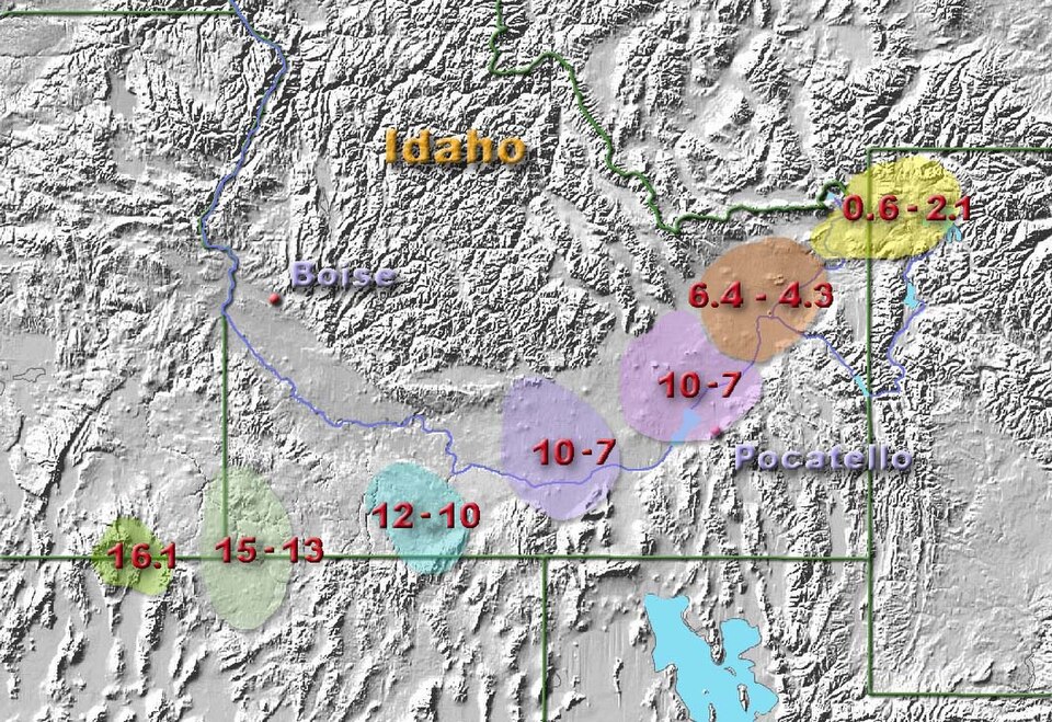
The track of the Yellowstone hotspot is defined by an arcuate chain of buried and partially exposed silicic volcanic centres extending from northern Nevada and southeastern Oregon to the modern Yellowstone Plateau, a distance of approximately 700 kilometres. Each volcanic centre consists of one or more rhyolitic calderas built during a discrete pulse of activity lasting roughly 2 to 4 million years, after which the locus of voluminous silicic volcanism shifted northeastward to the next centre and the previous one was buried beneath younger basaltic lavas erupted from monogenetic vents along the plain.3, 8 The composite topographic feature defined by these buried calderas is the Snake River Plain, a 100-kilometre-wide arcuate depression that contrasts sharply with the surrounding Basin and Range topography because the dense, mafic infill of the plain has caused it to subside while the unfilled basins to the north and south have remained elevated.8, 9
The oldest unambiguously hotspot-related volcanism is recorded in the McDermitt volcanic field straddling the Nevada–Oregon border, where five overlapping calderas erupted between approximately 16.5 and 15.0 million years ago. The largest event in the McDermitt sequence, the eruption of the McDermitt Tuff at 16.39 ± 0.02 Ma, emplaced approximately 1,000 cubic kilometres of strongly zoned peralkaline rhyolite to trachydacite ignimbrite — a volume comparable to the much younger Lava Creek Tuff at Yellowstone itself.10 Geochronological work by Henry and colleagues has shown that several smaller calderas in northwestern Nevada are slightly older still, with silicic eruptive activity attributable to the hotspot beginning around 16.7 million years ago. Within geological resolution, this initiation is contemporaneous with the main eruptive phase of the Columbia River Basalt Group to the north, suggesting that the two events are surface expressions of a single mantle phenomenon.10, 11
From the McDermitt centre, the locus of caldera-forming silicic volcanism shifted progressively northeastward through the Owyhee–Humboldt volcanic field (12.8–13.9 Ma), the Bruneau–Jarbidge volcanic field (10–12.5 Ma), the Twin Falls volcanic field (8.6–10 Ma), the Picabo volcanic field (~10.2 Ma), and the Heise volcanic field (4.45–6.6 Ma), each contributing one or more large ash-flow sheets to the regional stratigraphy.8, 18 The Heise field, the immediate predecessor of the Yellowstone Plateau volcanic field, produced at least four caldera-forming eruptions totalling more than 2,250 cubic kilometres of rhyolitic magma, with individual events such as the Kilgore Tuff (4.45 Ma) and Blacktail Creek Tuff (6.62 Ma) each exceeding 1,500 cubic kilometres — a scale rivalling the largest Yellowstone events.18
Age progression and plate motion
The most quantitatively rigorous evidence for a deep mantle source beneath Yellowstone is the systematic age progression of the silicic volcanic centres along the Snake River Plain. When the position of each major caldera is plotted against its eruption age, the data define a roughly linear trend with an apparent migration velocity of about 4.0 to 4.5 centimetres per year toward the northeast.8, 17 This rate is faster than the absolute motion of the North American Plate in a hotspot reference frame, which is approximately 2.3 to 2.5 centimetres per year toward the southwest. The discrepancy is interpreted as the contribution of intraplate extension associated with the Basin and Range province, which has stretched the western North American crust by 1 to 2 centimetres per year since the middle Miocene and added an apparent component of motion to the volcanic age progression.1, 17
The southwest direction of plate motion in the hotspot reference frame implies that the apparent northeast progression of volcanism reflects the plate moving over a stationary or slowly moving thermal source in the mantle, rather than the source itself migrating across the lithosphere. This is the foundational logic of the Wilson–Morgan hotspot hypothesis: if successive eruptive centres along a chain are progressively younger toward the present location of the active volcano, and if the rate and direction of progression match the independently determined plate motion, then a long-lived sub-lithospheric source must be responsible.8, 9 Yellowstone passes this test more clearly than any other continental hotspot.
Refined plate-motion calculations using GPS measurements of present-day deformation and palaeomagnetic reconstructions of past plate positions are broadly consistent with the volcanic age progression, although small departures from a perfectly linear track have been noted. The arcuate, slightly bent shape of the Snake River Plain may reflect either small variations in plate-motion direction over the past 16 million years, deflection of plume material by lithospheric structures, or differential extension of the overriding plate. Distinguishing among these possibilities is an active area of research.1, 18
Major calderas of the Yellowstone hotspot track
The succession of caldera-forming eruptions along the hotspot track provides one of the longest and most complete records of large silicic volcanism preserved in any continental setting. The table below summarises the principal volcanic centres in chronological order, with their best-determined ages, locations, and approximate cumulative magma volumes.
Caldera-forming volcanic centres of the Yellowstone hotspot track3, 8, 10, 14, 18
| Volcanic field | Age range (Ma) | Location | Largest eruption | Approx. cumulative volume |
|---|---|---|---|---|
| Northwest Nevada calderas | ~16.7–15.5 | NW Nevada / SE Oregon | multiple, ~150–500 km³ each | >1,000 km³ |
| McDermitt | 16.5–15.0 | Nevada–Oregon border | McDermitt Tuff, ~1,000 km³ | ~2,000 km³ |
| Owyhee–Humboldt | 13.9–12.8 | Idaho / Nevada / Oregon | multiple buried calderas | ~500 km³ |
| Bruneau–Jarbidge | 12.5–10.0 | S. Idaho | Cougar Point Tuff, >500 km³ | ~2,500 km³ |
| Twin Falls / Picabo | 10.2–8.6 | S. Idaho | Arbon Valley Tuff, ~600 km³ | ~1,500 km³ |
| Heise | 6.62–4.45 | SE Idaho | Kilgore Tuff, ~1,800 km³ | ~2,250 km³ |
| Yellowstone Plateau (1st cycle) | 2.08 | NW Wyoming / E Idaho | Huckleberry Ridge Tuff, ~2,450 km³ | ~2,450 km³ |
| Yellowstone Plateau (2nd cycle) | 1.30 | E Idaho (Henrys Fork) | Mesa Falls Tuff, ~280 km³ | ~280 km³ |
| Yellowstone Plateau (3rd cycle) | 0.631 | NW Wyoming | Lava Creek Tuff, ~1,000 km³ | ~1,000 km³ |
Cumulative volumes are approximate, in part because many of the older calderas are buried beneath younger Snake River Plain basalts and their eruptive products are accessible only as outflow ignimbrite sheets exposed on the margins of the plain. The total magma erupted along the hotspot track over 16.5 million years amounts to roughly 12,000 to 15,000 cubic kilometres of rhyolite, supplemented by an even larger volume of basaltic lava erupted from younger monogenetic vents covering the Snake River Plain itself.3, 8
The three Yellowstone super-eruptions
The current Yellowstone Plateau volcanic field is the most recent expression of the hotspot, comprising three distinct caldera-forming cycles within the past 2.1 million years. Each cycle began with the intrusion of a basaltic input that triggered melting and assembly of an upper-crustal rhyolitic magma body, climaxed in the catastrophic eruption of an ash-flow tuff and the collapse of the overlying crust to form a caldera, and concluded with the slow extrusion of post-caldera rhyolite lavas refilling the depression over hundreds of thousands of years. This was the framework established by Robert Christiansen's exhaustive geological mapping of the Yellowstone Plateau, published as U.S. Geological Survey Professional Paper 729-G in 2001 after more than three decades of fieldwork.3
The Huckleberry Ridge Tuff, erupted at approximately 2.08 million years ago, is the largest of the three Yellowstone super-eruptions and one of the largest known explosive eruptions on Earth. It emplaced approximately 2,450 cubic kilometres of rhyolitic ignimbrite and dispersed an additional 2,000 cubic kilometres of distal ash, producing a fallout layer that extended from southern California to the Mississippi River valley and from northern Mexico to southern Canada.13, 14 The eruption excavated the Island Park caldera, an approximately 65-by-95-kilometre depression now largely concealed beneath the younger Yellowstone caldera to the east and the Island Park rhyolite plateau of eastern Idaho. Recent work has shown that the Huckleberry Ridge Tuff was emplaced in three discrete pulses, designated members A, B, and C, separated by hiatuses of years to decades, rather than a single continuous eruption.14
The Mesa Falls Tuff was erupted approximately 1.30 million years ago in a much smaller event that produced about 280 cubic kilometres of ignimbrite and formed the 16-kilometre-wide Henrys Fork caldera within the older Huckleberry Ridge depression in eastern Idaho. New &sup4;⁰Ar/³⁹Ar dating of single sanidine crystals by Stelten and colleagues has refined the eruption age and bracketed the duration of pre-caldera and post-caldera magmatism around the Mesa Falls cycle, showing that the system was active from at least 1.4 to 1.2 million years ago.19 The Mesa Falls Tuff is the smallest and least extensively studied of the three Yellowstone super-eruptions, but its existence demonstrates that the Yellowstone magmatic system has produced both very large and intermediate-volume caldera-forming events.
The Lava Creek Tuff, erupted 631,000 years ago, is the youngest super-eruption and the source of the modern Yellowstone caldera, the 70-by-45-kilometre topographic depression that defines the heart of Yellowstone National Park. It deposited approximately 1,000 cubic kilometres of rhyolitic ignimbrite and an additional 250 cubic kilometres of distal ash that has been recognised at sites from Saskatchewan to northern Mexico.13, 14 Matthews, Vazquez, and Calvert in 2015 used combined &sup4;⁰Ar/³⁹Ar sanidine and U–Pb zircon dating to refine the eruption age to 631.3 ± 4.3 thousand years and to track the assembly history of the magma body, showing that zircon crystals in the tuff record at least 30,000 years of pre-eruptive crystallisation in the upper crust.12 Their work also revised the previous best estimate of 640,000 years that had been the standard age for more than two decades.
Following the Lava Creek eruption, the Yellowstone caldera has experienced two further cycles of intracaldera rhyolite extrusion, the first centred at the Mallard Lake resurgent dome in the southwest of the caldera and the second at the Sour Creek resurgent dome in the northeast. These post-caldera lavas, which include the prominent Pitchstone Plateau, Solfatara Plateau, and Central Plateau flows, have together added more than 600 cubic kilometres of rhyolite to the caldera fill since approximately 175,000 years ago. The youngest known eruption from the Yellowstone system is a small rhyolite flow at Pitchstone Plateau dated to approximately 70,000 years ago, although hydrothermal explosions have continued to the present.3, 14
Seismic imaging of the magmatic system
The deep structure of the Yellowstone magmatic system has been progressively revealed by successive generations of seismic experiments. The earliest tomographic studies in the 1980s and 1990s used regional networks of permanent seismic stations to image low-velocity anomalies beneath the caldera at depths of a few tens of kilometres, identifying what was then interpreted as a single upper-crustal magma chamber containing perhaps 10 to 30 percent partial melt. The deployment of denser temporary arrays in the 2000s, culminating in the EarthScope USArray traverse of the western United States, transformed the resolution of these images and made it possible to track the system from the upper crust to the deep mantle.1
The most influential modern study is the 2009 synthesis by Smith and colleagues, which combined regional and teleseismic body-wave tomography with GPS-derived models of crustal flow to image a low-velocity body extending from the upper crust beneath Yellowstone down to a depth of approximately 660 kilometres in the mantle transition zone. Smith et al. interpreted this anomaly as a tilted plume conduit dipping about 60 degrees to the west-northwest, containing roughly 1 to 2 percent partial melt and rising from an inferred source somewhere below the transition zone.1 The geometry of the imaged body — a cylindrical column more than 600 kilometres long with a width of order 100 kilometres — matched the predictions of numerical plume models reasonably well, although the tilt was attributed to deflection of the rising material by large-scale mantle flow associated with subduction along the western margin of North America.
Three years later, Schmandt and co-workers used dense USArray data to image an upward deflection of the 660-kilometre seismic discontinuity directly beneath the hotspot, observing that the discontinuity is elevated by 12 to 18 kilometres over an area roughly 200 kilometres across. Such an upward deflection is the predicted signature of a hot, buoyant upwelling crossing the endothermic phase boundary that marks the top of the lower mantle, and Schmandt et al. interpreted it as evidence for a thermal plume penetrating from the lower mantle into the transition zone beneath Yellowstone.7 Their model also resolved low-velocity material extending to at least 900 kilometres depth, well below the transition zone, providing the first robust seismic evidence that the Yellowstone source is not confined to the upper mantle.
The 2015 Science paper by Hsin-Hua Huang and collaborators added the upper-crustal piece of the puzzle. Combining local earthquake tomography from the University of Utah Yellowstone Seismograph Network with teleseismic data from the EarthScope array, Huang et al. imaged a previously unrecognised lower-crustal magma reservoir lying between approximately 19 and 45 kilometres depth, with a volume of about 46,000 cubic kilometres — roughly 4.4 times the size of the upper-crustal magma chamber known from earlier studies. The reservoir appears as a low-velocity body containing an estimated 2 percent partial melt and bridges the gap between the deep mantle plume and the shallow magma chamber that fed the Quaternary super-eruptions.2 Although this volume of magma is large in absolute terms, the partial-melt fraction is too low to support the kind of magma mobilisation that would precede a caldera-forming eruption, a point the authors emphasised explicitly.
The most recent major contribution comes from Peter Nelson and Stephen Grand, who used core-refracted SKS and SKKS phases recorded across the USArray to construct a shear-wave tomographic model of the entire mantle beneath the western United States. Their 2018 Nature Geoscience paper imaged a single narrow, cylindrically shaped low-velocity anomaly approximately 350 kilometres in diameter extending from the core–mantle boundary at 2,890 kilometres depth all the way to the base of the lithosphere beneath Yellowstone, tilted toward the northeast.6 The anomaly weakens upward, consistent with a thermal plume losing its buoyancy contrast as it rises. If the entire signal is thermal in origin, it implies an excess temperature of 650 to 850 degrees Celsius at the core–mantle boundary, comparable to the values inferred for the Hawaii and Iceland plumes. This study is widely regarded as the strongest seismic evidence to date for a whole-mantle plume origin of the Yellowstone hotspot.
Alternative models and the plume debate
Despite the seismic evidence assembled over the past two decades, the deep-plume hypothesis for Yellowstone has never gone unchallenged. The most influential alternative was articulated by Eugene Humphreys and colleagues in a 2000 GSA Today paper that argued for an upper-mantle origin for the hotspot, citing the absence of any clear plume-like seismic signal extending below approximately 200 kilometres in the available teleseismic data and the difficulty of reconciling the geological history of the system with the simple plume model.5 Humphreys and his co-workers proposed instead that the Yellowstone system reflects a feedback between subduction-driven upper-mantle convection beneath the western United States and the regional pattern of lithospheric extension, with the volcanism tracking the position where fertile mantle is drawn upward and depressurised by these flows rather than the position of a fixed deep source.
This argument was extended in 2002 by Robert Christiansen, Gillian Foulger, and John Evans in a Geological Society of America Bulletin paper titled "Upper-mantle origin of the Yellowstone hotspot." Christiansen, the author of Professional Paper 729-G and arguably the leading mapper of the Yellowstone Plateau, marshalled four main lines of evidence against a deep plume: the persistence of basaltic magmatism along the entire Snake River Plain rather than concentrated only at the present location of the hotspot; the apparent initiation of the system during a regional middle Miocene tectonic reorganisation rather than as an independent thermal anomaly; the strong control of the hotspot track by pre-existing lithospheric structures; and the absence of unambiguous seismic evidence for a vertically extensive plume conduit or a broad trailing plume head beneath the eastern Snake River Plain.4 Christiansen et al. argued that all of these features could be accounted for by upper-mantle processes acting on a heterogeneously hydrated and chemically fertilised lithospheric source, without invoking a deep plume at all.
The non-plume models have lost some of their force as seismic resolution has improved. The 2012 Schmandt et al. detection of a deflected 660-kilometre discontinuity, the 2018 Nelson and Grand whole-mantle imaging, and the 2015 Huang et al. integrated upper-mantle-to-crust model all point to a coherent low-velocity feature extending well below the depths originally inferred by Humphreys and colleagues.2, 6, 7 Even Pierce and Morgan, in a 2009 review paper, concluded that the cumulative weight of the geological and geophysical evidence favours a plume origin, although they acknowledged that none of the evidence is individually conclusive and that the deep-plume hypothesis still struggles to account for some aspects of the geochemistry and structural geology of the track.18 The current consensus, in so far as one exists, treats the deep plume model as the most parsimonious explanation while recognising that interaction with shallow lithospheric and sub-lithospheric processes is essential to producing the observed surface features.
The Columbia River Basalt connection
One of the strongest arguments for a deep mantle origin of the Yellowstone system comes not from beneath the present hotspot but from the fact that its initiation in the middle Miocene was contemporaneous with the eruption of the Columbia River Basalt Group, the youngest large igneous province on Earth. Between approximately 16.7 and 15.0 million years ago, more than 210,000 cubic kilometres of tholeiitic flood basalt was erupted from a swarm of north-northwest-trending fissures in eastern Oregon, eastern Washington, and western Idaho, blanketing an area of more than 200,000 square kilometres with stacked basalt flows that locally exceed 1,800 metres in thickness.11 The most recent geochronological work, by Kasbohm and Schoene in 2018, has shown that more than 95 percent of this volume was erupted in less than 800,000 years, twice as fast as previous estimates and at a rate comparable to the most intense pulses of the Deccan and Siberian Traps.
The temporal coincidence between the onset of the Columbia River Basalt eruptions and the oldest hotspot calderas in northwestern Nevada has long been interpreted as evidence that both phenomena reflect the arrival of a single mantle plume head at the base of the North American lithosphere around 17 million years ago. In this view, the broad, mushroom-shaped head of the rising plume produced the rapid, voluminous flood-basalt eruptions of the Columbia Plateau, while the narrow, persistent tail of the same plume has fed the smaller-volume but longer-lived Snake River Plain–Yellowstone hotspot track ever since. This was the original interpretation offered by Pierce and Morgan in 1992, who envisaged a plume head approximately 300 kilometres across intercepting the lithosphere at 16 to 17 Ma and a much narrower 10 to 20 kilometre chimney supplying the modern hotspot.8
The plume-head model is not the only explanation that has been proposed. Hales and colleagues in 2008 suggested an alternative in which delamination of the dense lower crust and mantle lithosphere beneath the Pacific Northwest, triggered rather than caused by a plume impact, produced the Columbia River Basalts through decompression melting of the upwelling asthenosphere that filled the void left by the sinking lithospheric block.20 In the delamination scenario, the apparent plume signature in the deep mantle beneath modern Yellowstone is a secondary feature unrelated to the main flood-basalt event. Distinguishing between the plume-head and delamination hypotheses is difficult because both can produce similar surface volcanism, and both are likely to play some role in the regional geodynamics of the Pacific Northwest.
Hydrothermal system and surface features
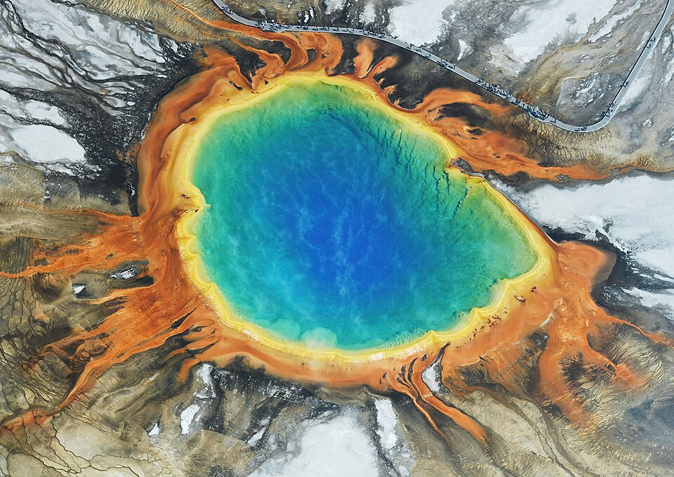
The most visible surface expression of the Yellowstone hotspot is its hydrothermal system, the largest and most diverse on Earth. Approximately 10,000 thermal features — including more than 500 active geysers, hundreds of hot springs, fumaroles, and mud pots — are concentrated within and around the 631,000-year-old Yellowstone caldera and its postcaldera resurgent domes. Yellowstone hosts roughly half of the world's geyser-bearing thermal areas, including Old Faithful, Steamboat Geyser (the world's tallest active geyser), Castle Geyser, and the Grand Prismatic Spring.14, 16
.jpg)
The total convective heat output from the Yellowstone hydrothermal system is large but uncertain. Lowenstern and Hurwitz, using the chloride-flux inventory method — which estimates heat flux from the mass of dissolved chloride exiting the park in the major rivers, multiplied by the enthalpy of the source fluid — arrived at a total heat output of approximately 5 to 6 gigawatts, or roughly 2,000 to 2,500 megawatts per square kilometre averaged over the caldera floor. This is approximately 30 times the average continental heat flow and comparable to the heat output of a small modern volcanic arc.16 Localised measurements in some thermal areas exceed 100 watts per square metre, more than 50 times the Yellowstone-wide average and roughly 2,000 times the heat flux of average North American continental crust. The heat is supplied entirely by conductive transfer from the underlying magmatic system through a circulating groundwater convection cell that extends to depths of perhaps 5 kilometres.
The system is also a major emitter of magmatic carbon dioxide. Werner and Brantley estimated in 2003 that approximately 45 ± 16 kilotonnes of CO&sub2; are released per day from diffuse degassing across the caldera, equivalent to roughly 16 megatonnes per year and comparable to the output of a small to moderate-sized volcanic arc.15 A more recent study by Pfeffer and colleagues, incorporating measurements from previously overlooked cold-degassing acid-sulfate soils, revised the deeply sourced flux downward to approximately 24 ± 12 kilotonnes per day but confirmed that diffuse soil emission rather than localised vent degassing is the dominant pathway.21 The carbon isotope composition of the emitted CO&sub2; is consistent with a mixture of mantle-derived and crustal-carbonate sources, indicating that some of the gas reflects assimilation and decarbonation of subducted carbonates carried into the deep mantle long ago.
Monitoring, deformation, and modern activity
Yellowstone is the most intensively monitored volcano in the United States. The Yellowstone Volcano Observatory, established in 2001 as a partnership of the U.S. Geological Survey, the University of Utah, and the National Park Service, operates more than two dozen continuous Global Positioning System receivers, five borehole strainmeter and tiltmeter stations, a Yellowstone Lake water-level network, and a dense seismometer network that records several thousand small earthquakes per year. The seismic network is operated by the University of Utah Seismograph Stations and has been continuously expanding since the 1970s, providing one of the longest unbroken records of background seismicity at any large silicic volcano.14
Caldera-floor deformation at Yellowstone has been monitored quantitatively since the 1923 first-order leveling survey, which when re-occupied in the 1970s revealed that the centre of the caldera had risen by approximately 70 centimetres in the intervening half-century — an unexpected finding that helped trigger the modern surge of interest in the system. Continuous GPS measurements since the 1990s have recorded alternating episodes of caldera-wide uplift and subsidence at rates of a few centimetres per year, with the most prominent recent uplift episode occurring between 2004 and 2010. Delgado and colleagues in 2021 used combined InSAR and GPS observations to model this episode as the result of a sequence of magmatic intrusions at depths of approximately 7 to 10 kilometres beneath the caldera, with successive sill-like bodies migrating laterally over several years before the system returned to subsidence.22 The total volume of intruded material in the 2004–2010 episode was approximately 0.1 to 0.2 cubic kilometres, three to four orders of magnitude smaller than the volume erupted in any of the three Quaternary super-eruptions.
Background seismicity at Yellowstone is dominated by small tectonic earthquakes triggered by stress changes associated with the regional Basin and Range extension and by hydrothermal activity, with an average of 1,500 to 2,500 located events per year. Earthquake swarms involving hundreds of events over a few weeks occur every few years, the largest in recent decades being the 1985 swarm of more than 3,000 events on the northwestern caldera margin and the 2008–2009 swarm beneath Yellowstone Lake. None of the historical seismicity has been interpreted as the precursor to an imminent eruption, although the Yellowstone Volcano Observatory routinely emphasises that the long repose intervals between past super-eruptions (~600,000 years on average) and the absence of any current sign of magma mobilisation toward the surface make a caldera-forming eruption in the foreseeable future an extremely low-probability event.14, 22
Significance and outstanding questions
The Yellowstone hotspot occupies a central place in continental geology and geodynamics for several reasons. It provides the clearest continental example of an age-progressive volcanic track and therefore the clearest test of the Wilson–Morgan plume hypothesis on continental lithosphere. It is the source of three of the largest known explosive eruptions of the Quaternary, allowing volcanologists to study the assembly, eruption, and post-eruptive evolution of supervolcano-scale silicic magma bodies in unprecedented detail. It hosts the world's most diverse hydrothermal system, with biological communities of extremophiles that have transformed our understanding of the limits of life and our methods for amplifying DNA. And it sits beneath one of the most populous and economically important regions of the western United States, making the assessment of its long-term hazards a matter of practical as well as scientific importance.14, 16
Several major questions remain unresolved. The geometry of the deep plume is still imperfectly known: the Nelson and Grand 2018 model places the plume's source at the core–mantle boundary, but the resolution of mantle tomography at such depths remains coarse and the inferred plume diameter (~350 kilometres) is large compared with the dimensions predicted by laboratory and numerical fluid-dynamic experiments.6 The origin of the apparent tilt of the upper-mantle conduit, and its connection to the deeper plume root, is unclear. The relative contributions of the plume itself, the regional Basin and Range extension, and pre-existing lithospheric structures to the geometry of the surface track are debated. The mechanism by which basaltic input from the deep system triggers the assembly of the much more voluminous rhyolitic upper-crustal magma bodies that fuel super-eruptions is only partly understood. And the timing and magnitude of the next caldera-forming eruption — if there is one — cannot at present be predicted with any confidence.18, 22
Yellowstone is therefore both the best-studied continental hotspot and a system whose deep workings remain under active investigation. The continuing improvement of seismic imaging through dense permanent and temporary networks, the refinement of geochronological techniques that have allowed the Lava Creek and other eruptions to be dated to a few thousand years out of more than 600,000, and the integration of these methods with geochemical, geodetic, and modelling approaches will all contribute to a sharper picture of how the hotspot has shaped the geology of the western United States and how it is likely to behave over the geologically near future.1, 2, 12
References
Geodynamics of the Yellowstone hotspot and mantle plume: Seismic and GPS imaging, kinematics, and mantle flow
The Quaternary and Pliocene Yellowstone Plateau volcanic field of Wyoming, Idaho, and Montana
Beneath Yellowstone: evaluating plume and nonplume models using teleseismic images of the upper mantle
Geology and evolution of the McDermitt caldera, northern Nevada and southeastern Oregon, western USA
Rapid eruption of the Columbia River flood basalt and correlation with the mid-Miocene climate optimum
Age of the Lava Creek supereruption and magma chamber assembly at Yellowstone based on &sup4;⁰Ar/³⁹Ar and U–Pb dating of sanidine and zircon crystals
Constraints on North American plate velocity from the Yellowstone hotspot deformation field
Is the track of the Yellowstone hotspot driven by a deep mantle plume? — Review of volcanism, faulting, and uplift in light of new data
The timing and origin of pre- and post-caldera volcanism associated with the Mesa Falls Tuff, Yellowstone Plateau volcanic field
Total diffuse CO&sub2; flux from Yellowstone caldera incorporating high CO&sub2; emissions from cold degassing sites
Dynamics of episodic magma injection and migration at Yellowstone caldera: revisiting the 2004–2009 episode of caldera uplift with InSAR and GPS data