Overview
- Catalhoyuk in central Turkey, occupied from roughly 7100 to 5950 BCE, is one of the largest and best-documented Neolithic settlements, providing unparalleled evidence for the social, dietary, and ritual transformations that accompanied the shift from mobile foraging to permanent village life.
- Several other sites across the Fertile Crescent and Anatolia illuminate different stages of the Neolithic transition, including Pre-Pottery Neolithic Jericho with its monumental tower, Gobekli Tepe with its hunter-gatherer-built megalithic sanctuaries predating agriculture, and Abu Hureyra where the shift from foraging to farming is documented within a single stratigraphic sequence.
- Bioarchaeological evidence from these early settlements reveals the Neolithic paradox: while agriculture enabled larger, denser populations, it simultaneously introduced increased rates of infectious disease, dental caries, nutritional deficiency, and interpersonal violence compared to preceding hunter-gatherer lifestyles.
The transition from mobile hunting and gathering to sedentary agricultural life was one of the most consequential transformations in human history, and its material evidence is preserved most vividly in the archaeological remains of the earliest permanent settlements. Across the Fertile Crescent and Anatolia, sites dating from roughly 9500 to 5000 BCE document successive stages of this process: the first year-round villages, the invention of food production, the emergence of dense aggregated communities, and the development of new forms of social organization, ritual life, and material culture.22 Among these sites, Catalhoyuk in south-central Turkey stands as one of the largest and most intensively studied Neolithic settlements, offering an exceptionally detailed window into how early farming communities lived, ate, worshipped, and died over more than a millennium of continuous occupation.1
The broader landscape of early Neolithic settlement extends well beyond Catalhoyuk. Pre-Pottery Neolithic Jericho in the Jordan Valley, Gobekli Tepe in southeastern Turkey, Abu Hureyra on the Euphrates, and Ain Ghazal near modern Amman each illuminate different dimensions of the Neolithic transition, from the construction of monumental architecture by pre-agricultural hunter-gatherers to the incremental adoption of crop cultivation and animal husbandry within single communities.10, 13, 14 Together, these sites reveal that the shift to settled life was neither sudden nor uniform, but rather a protracted, regionally variable process shaped by climate, ecology, demography, and the cultural choices of the communities involved.
Discovery and excavation of Catalhoyuk
Catalhoyuk is a large Neolithic tell site located on the Konya Plain of central Anatolia, Turkey. The site was first identified by the British archaeologist James Mellaart in November 1958 during a regional survey conducted with David French and Alan Hall. Mellaart recognized the exceptional size of the mound and the Neolithic date of the surface material, and he subsequently led four seasons of excavation between 1961 and 1965.2 His work uncovered more than 150 buildings and 480 burials, revealing a densely built settlement with elaborate wall paintings, plaster reliefs, and sculpted animal installations that were unlike anything previously known from the Neolithic period. Mellaart's 1967 monograph, Catal Huyuk: A Neolithic Town in Anatolia, brought the site to international attention and established it as one of the most important early farming communities in the world.2
Excavations resumed in 1993 under the direction of Ian Hodder of Stanford University, who initiated a long-term, multidisciplinary research project that continued until 2018. Hodder's project introduced new methodological approaches, including reflexive excavation practices, extensive flotation sampling for plant and animal remains, and the integration of archaeological science techniques such as stable isotope analysis, ancient DNA analysis, and micromorphology.1, 21 The modern excavations substantially expanded understanding of the site's chronology, subsistence economy, social organization, and symbolic life, producing a body of published research that has made Catalhoyuk one of the most comprehensively documented archaeological sites of any period.
Bayesian radiocarbon modelling has established that the main East Mound at Catalhoyuk was occupied from approximately 7100 to 5950 cal BCE, a span of roughly 1,150 years.4 A smaller West Mound, separated from the East Mound by a paleochannel, was occupied during the early Chalcolithic period that followed. The site's long, unbroken occupation sequence provides an exceptional record of continuity and change within a single Neolithic community.
Architecture and settlement layout
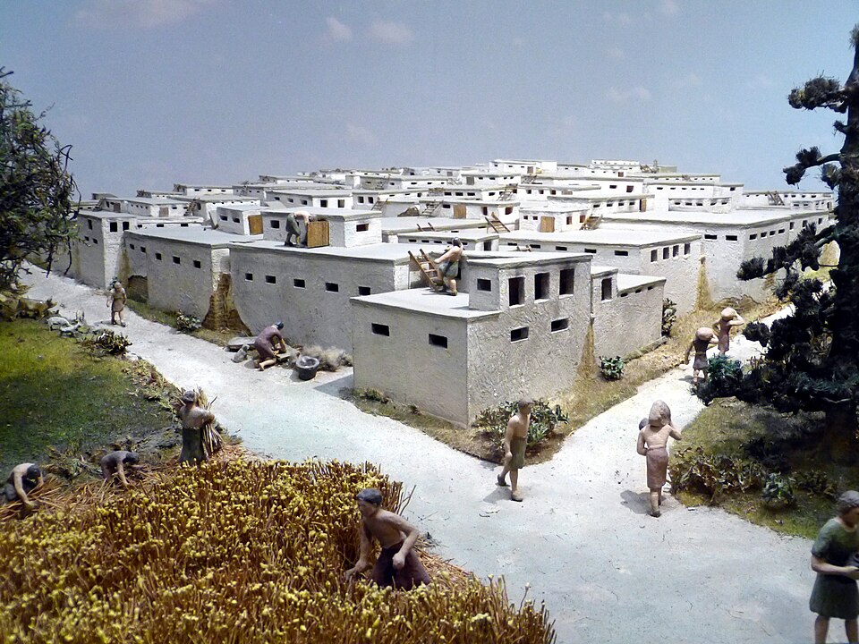
The most striking physical characteristic of Catalhoyuk is its densely aggregated architecture. The settlement consisted of closely packed mud-brick houses built directly against one another, with no streets or ground-level passageways between them. Residents entered their houses through openings in the roof, descending by ladder into the main living space below. The rooftops served as the primary circulation space for the community, functioning simultaneously as pathways, work areas, and gathering places.1, 3
Individual houses were broadly similar in plan: rectangular single-room structures typically measuring 20 to 30 square metres, with internal features including raised sleeping platforms, storage bins, hearths, and ovens. The interior walls were plastered and replastered repeatedly with fine white clay, sometimes dozens of times over the life of a building. When a house reached the end of its useful life, it was carefully demolished to a uniform height, filled with clean rubble, and a new house was constructed on top of the old one, creating the characteristic tell (artificial mound) stratigraphy that accumulated over centuries.3
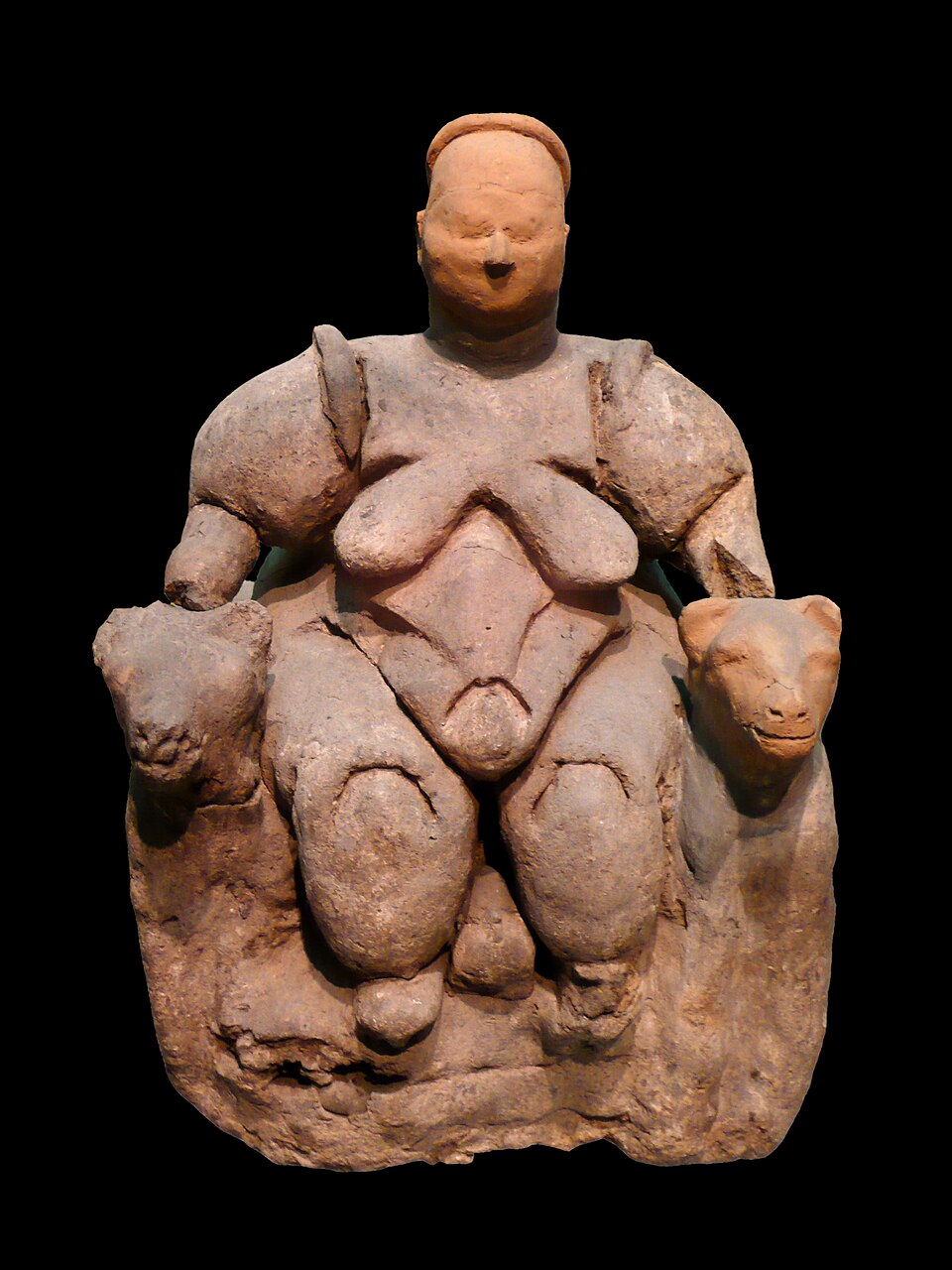
A subset of buildings at Catalhoyuk were distinguished by elaborate symbolic installations. These included wall paintings depicting geometric patterns, hunting scenes, and what appear to be representations of vultures interacting with headless human figures. Particularly notable were the bucrania, cattle horn installations mounted on clay pillars or benches within houses, and plaster reliefs of animal forms modelled directly onto the walls.2, 21 Mellaart interpreted these elaborated structures as communal shrines, but Hodder's subsequent analysis argued that they were domestic houses with varying degrees of symbolic elaboration rather than functionally distinct religious buildings, reflecting the integration of ritual into everyday household life.1, 3
Population and community size
Estimating the population of Catalhoyuk has been a persistent challenge. Early estimates, based on the density of buildings across the 13-hectare East Mound and assumptions about simultaneous occupation, suggested a population of 3,500 to 8,000 people, which would have made it by far the largest settlement in the world during the seventh millennium BCE.2, 5 These figures were widely cited in the literature and contributed to Catalhoyuk's reputation as the world's first proto-city.
However, a 2024 reassessment by Ian Kuijt and Arkadiusz Marciniak, published in the Journal of Anthropological Archaeology, substantially revised these estimates downward. Using revised data on the proportion of residential versus non-residential buildings, contemporaneity of occupation, and ethnographic analogies for household size, Kuijt and Marciniak estimated that approximately 600 to 800 people lived at Catalhoyuk East during an average year in the Middle phase (roughly 6700 to 6500 BCE).8 Their analysis found that residential buildings constituted only about 40 percent of the excavated structures, that only roughly 70 percent of residential buildings were occupied at any given time, and that children under five years of age accounted for approximately 30 percent of the population, a demographic profile consistent with high-fertility Neolithic populations.8
Population estimates for Catalhoyuk East Mound2, 5, 8
| Study | Method | Estimated population |
|---|---|---|
| Mellaart (1967) | Building density extrapolation | ~5,000–6,000 |
| Cessford (2005) | Household size × building count | ~3,500–8,000 |
| Kuijt & Marciniak (2024) | Revised occupancy, residential fraction, ethnographic analogy | ~600–800 |
Even at the lower revised estimate, Catalhoyuk represented a community significantly larger than contemporary villages elsewhere in Anatolia and the Levant, and the challenge of sustaining several hundred people in permanent co-residence would have required new social mechanisms for conflict resolution, resource sharing, and cooperative labour.5, 8
Diet and subsistence economy
The subsistence economy of Catalhoyuk combined crop cultivation, animal management, and the exploitation of wild plant and animal resources. Archaeobotanical analysis of the 1,500-year occupation sequence has documented a diverse crop spectrum including emmer wheat, einkorn wheat, free-threshing bread wheat, naked barley, lentils, peas, and bitter vetch, supplemented by wild plants such as almonds, pistachios, hackberries, and figs.6 Amy Bogaard and colleagues have argued that the long-term resilience of the community rested on three factors: the diversity of the initial crop assemblage, which provided an archive of genetic variation for later innovation; a modular social structure that allowed household-level experimentation in cropping practices; and the aggregated settlement form, which facilitated the scaling up of successful agricultural techniques across the wider community.6
Stable carbon and nitrogen isotope analysis of human and animal bone collagen has provided complementary evidence for diet. Jessica Pearson and colleagues found that the isotopic signatures of Catalhoyuk residents were consistent with a diet dominated by C3 cereals and legumes, supplemented by animal protein from sheep, goat, and cattle, with limited but detectable contributions from freshwater fish and wild resources.7 Isotopic data also revealed dietary consistency across age groups and between the sexes, suggesting relatively equal access to food resources within the community, a pattern consistent with the broader evidence for social egalitarianism at the site.7, 3
Animal management at Catalhoyuk underwent a significant transition over the occupation sequence. In the earliest levels, the faunal assemblage was dominated by wild cattle (aurochs), with sheep and goat present but contributing a smaller proportion of the meat diet. Over time, the relative contribution of domesticated sheep and goat increased while reliance on wild aurochs declined, documenting a gradual intensification of pastoral husbandry within the life of the settlement.5, 6
Health and the Neolithic paradox
One of the most significant findings from Catalhoyuk has been the detailed bioarchaeological evidence for the health consequences of settled agricultural life. The concept of the Neolithic paradox refers to the counterintuitive observation that the adoption of agriculture, despite enabling larger populations and greater food security, was accompanied by a general decline in individual health relative to preceding hunter-gatherer populations.16 The landmark 1984 edited volume by Mark Nathan Cohen and George Armelagos, Paleopathology at the Origins of Agriculture, documented this trend across 19 of 21 societies undergoing the agricultural transition worldwide.16
Clark Spencer Larsen's comprehensive 2019 bioarchaeological study of nearly 750 individuals from Catalhoyuk, published in PNAS, provided the most detailed documentation to date of these health transitions within a single Neolithic community. The study found increasing rates of dental caries over the occupation sequence, consistent with a diet increasingly reliant on starchy carbohydrates from cultivated cereals. Rates of cribra orbitalia and porotic hyperostosis, skeletal indicators of anemia and nutritional stress, were also elevated, particularly in the later phases of occupation.5
The Larsen study further documented a significant increase in the frequency of cranial trauma injuries over time, with approximately 25 percent of examined skulls showing evidence of healed depressed fractures, predominantly on the posterior of the cranium, suggesting interpersonal violence from behind. The frequency of these injuries increased in the later occupation levels, coinciding with evidence for greater population density and, potentially, increased social stress.5 Infections also became more prevalent as the settlement grew denser, a pattern consistent with the general bioarchaeological finding that aggregated Neolithic communities created conditions favourable for the transmission of communicable diseases.16, 17
Cross-cultural comparisons have confirmed that the pattern observed at Catalhoyuk was not unique. A global meta-analysis by Amanda Mummert and colleagues found that early agricultural populations experienced average reductions in stature of several centimetres relative to their foraging predecessors, reflecting chronic nutritional stress during growth, likely caused by dependence on a narrow range of staple crops, seasonal food shortages, and the diversion of resources to support larger numbers of dependent children.17, 18
Health indicators at Catalhoyuk across occupation phases5
Social organization and ritual life
The question of social organization at Catalhoyuk has been a central focus of debate. Hodder has argued that during its middle occupation phases, the site was characterized by an aggressively egalitarian social structure, in which no single household or lineage held lasting authority over others. The evidence for this interpretation includes the uniformity of house size and plan, the absence of buildings that could be identified as administrative or elite residences, the broadly equal distribution of food resources as indicated by isotopic data, and the lack of wealth differentiation in most burial assemblages.3, 7
However, the picture is not entirely uniform. In the later occupation levels, some houses contain richer burial assemblages, including individuals adorned with jewellery, finely worked obsidian tools, and polished obsidian mirrors, suggesting the emergence of at least modest social differentiation over time.3 A 2025 ancient DNA study published in Science by Maciej Chylenski and colleagues revealed that co-burial within houses at Catalhoyuk did not follow patrilineal kinship patterns as had been widely assumed; instead, burials within houses were organized primarily around female lineages, and many co-buried individuals were not close biological relatives at all, indicating that household membership was constructed through social rather than purely biological kinship ties.24
Ritual and symbolic life permeated the domestic sphere at Catalhoyuk. The dead were buried beneath the floors and platforms of the houses in which they had lived, maintaining a physical connection between the living and their ancestors. Wall paintings were periodically created and then plastered over, bucrania were installed and later removed, and deposits of animal bones and other materials were placed in pits within and between houses in what appear to have been structured acts of deposition.1, 21 Hodder has interpreted these practices as evidence for a symbolic system centred on themes of death, rebirth, and the domestication of wild nature, in which the wild bull (aurochs) served as a key symbol mediating the transition from the wild to the domestic world.1
Pre-Pottery Neolithic Jericho
The site of Tell es-Sultan, ancient Jericho, in the Jordan Valley was among the first Neolithic settlements to be excavated scientifically. Kathleen Kenyon's excavations between 1952 and 1958 established the fundamental chronological framework for the Pre-Pottery Neolithic period, defining the phases that are still used today: Pre-Pottery Neolithic A (PPNA, roughly 9500 to 8500 BCE) and Pre-Pottery Neolithic B (PPNB, roughly 8500 to 7000 BCE).9
The most remarkable architectural feature of PPNA Jericho is a stone tower approximately 8.5 metres tall and 9 metres in diameter at its base, with an internal staircase of 22 steps. Constructed around 8000 BCE, the tower is one of the earliest known monumental stone structures built by humans.9, 23 The function of the tower has been debated since its discovery: proposals have included defensive fortification, flood control, symbolic display of communal authority, and astronomical or calendrical significance. Whatever its purpose, the tower's construction required a degree of coordinated labour and planning that attests to the organizational capacity of the PPNA community at Jericho.23
During the PPNB, Jericho expanded and its material culture became more elaborate. Rectangular mud-brick houses with plastered floors replaced the earlier circular structures, and a distinctive mortuary practice emerged in which the skulls of the dead were removed after burial, modelled with plaster to recreate facial features, and displayed within houses. These plastered skulls have been found at multiple PPNB sites across the Levant and are interpreted as evidence for ancestor veneration and the ritual maintenance of connections between the living and the dead, a practice that finds echoes in the sub-floor burials at later Catalhoyuk.9, 19
Gobekli Tepe and pre-agricultural monumentality
Gobekli Tepe, located on a limestone ridge near the city of Sanliurfa in southeastern Turkey, has fundamentally altered understanding of the relationship between monumentality, social complexity, and agriculture. The site was first identified by Klaus Schmidt of the German Archaeological Institute in 1994 and excavated from 1995 until Schmidt's death in 2014 and beyond.10 Radiocarbon dating places the main phase of construction between approximately 9600 and 8200 BCE, making it broadly contemporary with PPNA settlements in the Levant and substantially predating the earliest evidence for plant or animal domestication in the region.10, 11
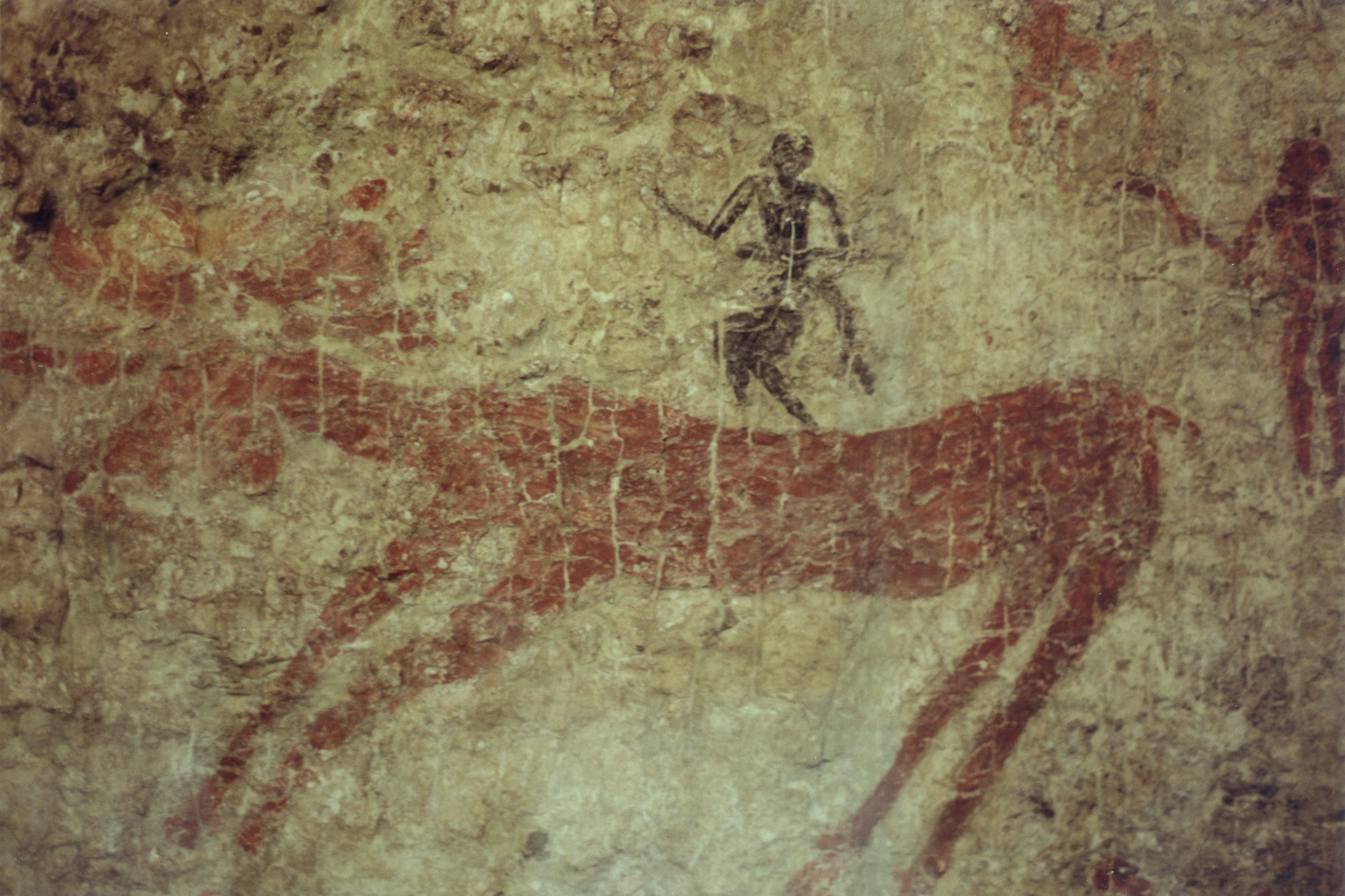
The monumental architecture at Gobekli Tepe consists of massive T-shaped limestone pillars, the largest exceeding 5 metres in height and weighing up to 10 tonnes, arranged in circular or oval enclosures. The pillars are carved with elaborate reliefs depicting animals including foxes, boars, snakes, vultures, scorpions, and wild cattle, as well as abstract symbols. Some pillars bear anthropomorphic features such as arms, hands, and belts, suggesting that they represent stylized human figures or supernatural beings.10, 20
The critical significance of Gobekli Tepe lies in the fact that its builders were, by all available evidence, hunter-gatherers who had not yet adopted agriculture. No domesticated plant or animal remains have been recovered from the early levels, and the faunal assemblage is dominated by wild game, particularly gazelle and aurochs. The site lacks permanent domestic architecture characteristic of year-round settlements, and Schmidt argued that it functioned as a ritual centre to which dispersed hunter-gatherer groups periodically congregated for feasting and ceremonial activity.10, 11 Oliver Dietrich and colleagues have presented evidence for large-scale beer production from wild cereals at the site, suggesting that communal feasting lubricated the social cooperation necessary to quarry, transport, and erect the massive pillars.11
Gobekli Tepe challenged the long-held assumption that monumental architecture and complex symbolic systems were products of agricultural surplus and sedentary life. Instead, it suggested that the social demands of ritual and communal gathering may have themselves contributed to the conditions that eventually led to the domestication of cereals in the region, inverting the conventional causal sequence between agriculture and social complexity.11, 22
Abu Hureyra and Ain Ghazal
Abu Hureyra, located on the Euphrates River in northern Syria, is one of the few archaeological sites in the world where the entire transition from foraging to farming is documented within a continuous stratigraphic sequence. Excavated by Andrew Moore in 1972 and 1973 before the site was flooded by the construction of Lake Assad, Abu Hureyra revealed two superimposed villages. The first village (Abu Hureyra 1), dating to roughly 11,500 to 10,000 BCE, was inhabited by hunter-gatherers who exploited a diverse array of wild plants and animals, with a particular focus on Persian gazelle.13
Gordon Hillman's archaeobotanical analysis of the Abu Hureyra 1 deposits produced evidence for the cultivation of rye and other cereals beginning around 11,000 BCE, during or immediately after the Younger Dryas climatic reversal, which severely reduced the availability of wild plant foods in the region. If confirmed, this would represent some of the earliest evidence for deliberate cereal cultivation anywhere in the world, and it supports the hypothesis that climate-driven resource stress was a proximate trigger for the adoption of farming in some regions.12 The second village (Abu Hureyra 2), dating to roughly 9700 to 7000 BCE, was a large PPNB farming settlement whose inhabitants cultivated wheat, barley, and lentils and herded sheep, goats, cattle, and pigs, representing a fully agricultural economy.13
Ain Ghazal, located on the outskirts of modern Amman, Jordan, is one of the largest known Pre-Pottery Neolithic settlements in the Levant. Excavated by Gary Rollefson and Alan Simmons beginning in 1982, the site covers approximately 15 hectares at its maximum extent during the PPNB period and may have housed a population of several thousand.14 The occupation sequence at Ain Ghazal spans from the early PPNB through the late Neolithic, and it documents a significant economic shift: early levels show a broad subsistence base combining domesticated crops with hunted wild animals, while later levels reveal an increasing emphasis on pastoral herding of goats, possibly in response to environmental degradation caused by deforestation and overexploitation of the local landscape.14
Ain Ghazal is also notable for the discovery of a cache of large plaster statues, dating to approximately 6750 BCE, which are among the oldest large-scale human figures known. These statues, some standing nearly a metre tall, were modelled from lime plaster over reed armatures and feature painted eyes and other facial details. Their deliberate burial in pits beneath the settlement floor suggests a ritual function, perhaps related to ancestor veneration or the maintenance of community identity.14
The spread of the Neolithic package
The suite of domesticated crops, livestock, technologies, and settlement practices that emerged in the Fertile Crescent during the Pre-Pottery Neolithic period is often referred to collectively as the Neolithic package. This package, which in its fullest expression included emmer and einkorn wheat, barley, lentils, peas, flax, sheep, goats, cattle, and pigs, along with associated technologies such as ground stone tools, mud-brick architecture, and storage facilities, spread progressively outward from its region of origin over the following millennia.22, 19
The mechanisms by which the Neolithic package spread have been a subject of intense debate. Albert Ammerman and Luigi Luca Cavalli-Sforza proposed the demic diffusion model in the early 1970s, arguing that the spread of agriculture into Europe was driven primarily by the migration of farming populations, who expanded at an average rate of approximately 1 kilometre per year along a southeast-to-northwest trajectory from Anatolia across the Balkans and into central and western Europe.15 Genetic evidence has broadly supported the demic diffusion model, showing that European farming populations derived substantial ancestry from Anatolian migrants, though the process also involved varying degrees of admixture with local hunter-gatherer populations and cultural transmission of farming knowledge.15
The Neolithic transition was not a single event but a mosaic of regional processes. In the Levant, sedentary villages with incipient cultivation appeared during the Natufian period (roughly 12,500 to 9500 BCE), well before the full Neolithic package crystallized.19 In central Anatolia, Catalhoyuk represents a community that had already fully adopted agriculture by the time of its founding around 7100 BCE, but whose crop management practices and animal husbandry continued to evolve over the subsequent millennium.6 In southeastern Turkey, Gobekli Tepe demonstrates that complex social organization and monumental construction could precede rather than follow the adoption of farming.10 These varied trajectories underscore that the Neolithic revolution was not a single invention that diffused outward from a single centre, but rather a convergent process driven by broadly similar ecological and demographic pressures acting on human societies across a wide geographic area.22
Key early Neolithic settlements in the Fertile Crescent and Anatolia1, 9, 10, 13, 14
| Site | Location | Approximate dates | Key features |
|---|---|---|---|
| Gobekli Tepe | SE Turkey | ~9600–8200 BCE | Megalithic T-pillars, pre-agricultural ritual centre |
| Jericho (Tell es-Sultan) | Jordan Valley | ~9500–7000 BCE | PPNA tower, PPNB plastered skulls |
| Abu Hureyra | N Syria (Euphrates) | ~11,500–7000 BCE | Foraging-to-farming transition in single sequence |
| Ain Ghazal | Jordan (near Amman) | ~8500–5000 BCE | 15 ha PPNB settlement, plaster statues |
| Catalhoyuk | Central Turkey (Konya Plain) | ~7100–5950 BCE | Dense aggregated settlement, bucrania, wall paintings |
The archaeological record of these early settlements demonstrates that the Neolithic transition was one of the most transformative episodes in human history, fundamentally reshaping human biology, social organization, material culture, and the relationship between human communities and the natural world. The consequences of the choices made by the inhabitants of Catalhoyuk, Jericho, Gobekli Tepe, Abu Hureyra, and Ain Ghazal continue to reverberate in the agricultural economies, urban landscapes, and social structures of the modern world.22, 18
References
Getting to the bottom of it all: a Bayesian approach to dating the start of Catalhoyuk
Bioarchaeology of Neolithic Catalhoyuk reveals fundamental transitions in health, mobility, and lifestyle in early farmers
Agricultural innovation and resilience in a long-lived early farming community: the 1,500-year sequence at Neolithic to early Chalcolithic Catalhoyuk, central Anatolia
Stable carbon and nitrogen isotope analysis and dietary reconstruction through the life course at Neolithic Catalhoyuk, Turkey
How many people lived in the world’s earliest villages? Reconsidering community size and population pressure at Neolithic Catalhoyuk
The role of cult and feasting in the emergence of Neolithic communities: new evidence from Gobekli Tepe, south-eastern Turkey
Stature and robusticity during the agricultural transition: evidence from the bioarchaeological record
Gobekli Tepe – the Stone Age sanctuaries: new results of ongoing excavations with a special focus on sculptures and high reliefs
Architecture, sedentism, and social complexity at Pre-Pottery Neolithic A WF16, southern Jordan