Overview
- The Inca Empire (Tawantinsuyu) was the largest state in pre-Columbian America, spanning approximately 2 million square kilometres along 4,000 kilometres of the Andean cordillera from southern Colombia to central Chile, and governing an estimated 10 to 12 million people at its peak in the early sixteenth century.
- Despite lacking a conventional writing system, wheeled transport, or iron tools, the Inca administered their empire through an extraordinarily sophisticated system of knotted-string records (khipu), a 30,000-kilometre road network (Qhapaq Ñan), decimal-based provincial organisation, and a rotational labour tax (mit'a) that mobilised millions of workers for state construction, agriculture, and military service.
- The empire rose from a small polity in the Cusco Valley around 1200 CE to continental dominance in barely a century under rulers such as Pachacuti and Tupac Inca Yupanqui, only to be conquered by fewer than 200 Spanish soldiers under Francisco Pizarro in 1532 — a collapse accelerated by civil war, epidemic disease, and the capture of the emperor Atahualpa at Cajamarca.
The Inca Empire, known in Quechua as Tawantinsuyu ("the four regions together"), was the largest state ever established in the pre-Columbian Americas.1 At its greatest extent in the early sixteenth century, the empire stretched approximately 4,000 kilometres along the western spine of South America, from the Ancasmayo River in southern Colombia to the Maule River in central Chile, encompassing roughly 2 million square kilometres of coastal desert, highland valleys, and tropical forest across the Andean cordillera.1, 14 Governing an estimated 10 to 12 million people drawn from more than one hundred distinct ethnic groups, the Inca achieved this continental dominion in barely a century — an expansion from a small kingdom in the Cusco Valley to pan-Andean hegemony that represents one of the most rapid episodes of state formation in human history.1, 3 The empire accomplished this without a conventional writing system, wheeled transport, draught animals, or iron metallurgy, relying instead on an intricate bureaucratic apparatus of knotted-string records, an unparalleled road network, and a labour-based economy that mobilised entire populations for state purposes.1, 6
Origins and the rise of the Inca state
Archaeological evidence from the Cusco Valley in the southern Peruvian highlands reveals a long sequence of human occupation extending back to at least 7000 BCE, with small-scale agropastoral communities cultivating potatoes, quinoa, and other Andean crops and herding camelids (llamas and alpacas) by the second millennium BCE.2, 12 The Inca origin myths, recorded by Spanish chroniclers in the sixteenth century, describe the emergence of the first Inca ruler, Manco Capac, and his siblings from a cave at Pacariqtambo (Tambotoco), roughly 30 kilometres south of Cusco, whence they journeyed to the Cusco Valley and founded the city.7 Brian Bauer's archaeological survey of the Pacariqtambo region has demonstrated that the mythical geography corresponded to a real political landscape of competing small polities in the centuries before Inca dominance, and that the origin narratives served to legitimise the ruling lineage's authority over rival groups in the valley.7, 19
The Kingdom of Cusco emerged as a recognisable polity around 1200 CE, one of several small chiefdoms competing for control of the fertile intermontane basins of the southern highlands.2, 20 Archaeological survey data indicate that the early Inca polity was initially confined to the Cusco Basin itself, with a population of perhaps 20,000 to 30,000, and that its material culture was not dramatically different from that of its neighbours.20, 12 The transformation from regional chiefdom to expansionist empire is traditionally attributed to Pachacuti Inca Yupanqui (r. c. 1438–1471), who according to chronicle accounts defeated the rival Chanca confederation in a decisive battle outside Cusco, reorganised the city with monumental stone architecture, and launched the first great campaigns of territorial conquest.1, 3 However, recent AMS radiocarbon dating of Machu Picchu — built as Pachacuti's royal estate — places its initial construction around 1420 CE, suggesting that imperial expansion may have begun at least two decades earlier than traditional chronologies indicate.13
The expansion continued under Pachacuti's son, Tupac Inca Yupanqui (r. c. 1471–1493), who conquered the powerful coastal Chimú kingdom, extended Inca control south into Chile and northwestern Argentina, and pushed the northern frontier deep into Ecuador.1, 14 Bayesian radiocarbon models from sites in Ecuador and Argentina confirm that Inca presence in these peripheral regions dates to the late fifteenth century, broadly consistent with the chronicle chronology for Tupac Inca's campaigns.14 His successor, Huayna Capac (r. c. 1493–1527), consolidated northern conquests and established a second imperial capital at Tomebamba (modern Cuenca, Ecuador), but died during an epidemic — likely introduced through indirect contact with Europeans — that also killed his designated heir and precipitated a devastating civil war between his sons Atahualpa and Huascar.1, 4
Political organisation and administration
Tawantinsuyu was divided into four great provinces or suyus — Chinchaysuyu (northwest), Antisuyu (northeast), Collasuyu (southeast), and Cuntisuyu (southwest) — radiating from the imperial capital of Cusco, which the Inca conceived as the navel of the world.1 Each suyu was governed by an apu drawn from the Inca aristocracy, and was further subdivided into provinces corresponding roughly to pre-existing ethnic territories, each administered by a provincial governor (tocricuc) answerable to the Sapa Inca in Cusco.1, 3
Below the provincial level, the Inca imposed a distinctive decimal administration that organised subject populations into nested units of 10, 50, 100, 500, 1,000, 5,000, and 10,000 households, each headed by a local official (curaca) responsible for labour mobilisation, census-taking, and tribute collection.1, 10 This system did not necessarily reflect actual population counts but provided an administrative framework for the empire's most important institution: the mit'a, a rotational labour tax that required every household to contribute a specified number of days of work per year to state projects.1, 10 Unlike most ancient empires, the Inca levied no tribute in goods; instead, the state extracted labour, which was directed toward agriculture on state and religious lands, construction of roads and storehouses, textile production, military service, and the maintenance of the imperial communication system.1, 10 Analysis of khipu records from the administrative centre of Inkawasi has revealed the accounting mechanisms by which mit'a obligations were tracked, with separate cord groups recording the number of workers, the type of labour performed, and the quantities produced.10
The ruling Sapa Inca ("sole ruler") stood at the apex of the political hierarchy, claiming descent from the sun god Inti and exercising theoretically absolute authority over all land, resources, and people within Tawantinsuyu.1, 19 In practice, Inca rule depended heavily on negotiation and alliance with local elites, who were incorporated into the imperial system through a combination of lavish gift-giving, strategic marriages, and the threat of military force.1, 3 Conquered communities that resisted were subject to mass resettlement (mitmaqkuna), in which entire populations were relocated to distant provinces and replaced with loyal colonists — a strategy that simultaneously broke local resistance and distributed specialised labour across the empire's diverse ecological zones.1
The khipu recording system
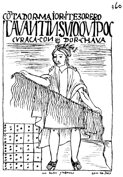
In the absence of a conventional writing system, the Inca administered their vast empire through khipu (also spelled quipu), devices consisting of a primary cord from which hung pendant strings of spun and dyed cotton or camelid fibre, with information encoded in the colour, spin direction, ply, and knotting patterns of each string.6, 8 Approximately 1,000 khipu survive in museum collections worldwide, and their study has been one of the most active areas of Andean scholarship since the late twentieth century.6
_p360.png)
Gary Urton and Carrie Brezine's analysis of 21 khipu excavated from the site of Puruchuco near Lima demonstrated that these devices recorded a hierarchical accounting system in which numerical data from lower-level administrative units were aggregated on higher-level cords, producing summaries that flowed upward through the decimal bureaucracy to the central administration in Cusco.8 Separate khipu archives at Inkawasi reveal the systematic recording of mit'a labour inputs and agricultural production, with duplicate accounts maintained at different administrative levels to enable cross-checking — a practice analogous to double-entry bookkeeping.10, 11
Whether khipu also encoded narrative or phonetic information beyond numerical data has been a matter of long-standing debate. Sabine Hyland's 2017 study of two khipu epistles from the community of San Juan de Collata identified 95 distinct combinations of fibre type, colour, and spin direction on pendant cords, a repertoire large enough to constitute a logosyllabic writing system capable of recording language.9 If confirmed through further analysis, this finding would fundamentally alter understanding of Inca literacy and information management, demonstrating that Tawantinsuyu possessed a full writing system — albeit one radically different in medium from any other known script.9, 6
The Qhapaq Ñan road network
The Qhapaq Ñan ("royal road") was the arterial infrastructure that held the Inca Empire together, a network of roads and associated facilities totalling more than 30,000 kilometres that connected every corner of Tawantinsuyu from the tropical lowlands of the Amazon fringe to the arid coasts of Peru and Chile.5, 21 Inscribed as a UNESCO World Heritage Site in 2014 across six modern nations (Argentina, Bolivia, Chile, Colombia, Ecuador, and Peru), the road system represents one of the greatest engineering achievements of the pre-industrial world.21
Two principal trunk roads ran the length of the empire: a highland route traversing the Andean spine at elevations frequently exceeding 4,000 metres, and a parallel coastal road crossing the deserts of the Pacific littoral.5, 1 Lateral roads connected these two axes across the formidable terrain of the western Andes, requiring suspension bridges of braided fibre cables spanning gorges up to 45 metres wide, stairways carved into sheer rock faces, and causeways built across marshlands and high-altitude bogs.5, 22 At regular intervals of approximately 20 to 25 kilometres — a day's march — the roads were punctuated by tampu (way stations) providing lodging, food stores, and fresh relay runners (chasqui) who could carry messages the length of the empire in as few as five to seven days.1, 5
The road network served military, economic, and administrative functions simultaneously. Armies could be mobilised and deployed across hundreds of kilometres of difficult terrain with remarkable speed; state-produced goods — textiles, ceramics, dried foodstuffs, and metal objects — flowed between ecological zones through a redistributive economy managed from regional storehouses (qollqa) positioned along the road; and khipu-bearing administrators and chasqui messengers maintained the flow of information that made centralised governance of so vast and geographically fragmented a territory possible.1, 5, 22
Estimated extent of the Qhapaq Ñan across modern nations21
Agriculture and economy
The Inca economy was fundamentally agrarian and operated without markets, money, or private commerce in the conventional sense.1 The state claimed ownership of all land, which was divided into three notional categories: lands worked for the Sapa Inca and the state, lands dedicated to the sun god and the religious establishment, and community lands (ayllu holdings) whose produce sustained local populations.1, 10 The mit'a labour tax, rather than tribute in kind, was the engine of the state economy: households owed labour on state and religious lands, and the resulting agricultural surplus was stored in thousands of qollqa (storehouses) distributed along the road network, providing food reserves for armies, labourers on state projects, and communities affected by crop failure.1, 10
Andean agriculture had developed over millennia a suite of techniques superbly adapted to the extreme altitudinal and climatic gradients of the Andes.1, 18 Agricultural terracing (andenes) converted steep mountain slopes into productive farmland while controlling erosion and creating microclimates that extended the range of cultivable crops to higher elevations.1 The Inca cultivated an extraordinary diversity of crops across their empire's ecological zones: more than 3,000 varieties of potato in the highlands, maize in the temperate valleys, quinoa and other pseudocereals at high altitude, and coca, chilli peppers, and tropical fruits in the warm eastern lowlands.1, 18 A particularly ingenious innovation was the production of chuño, freeze-dried potatoes created by exploiting the sharp diurnal temperature oscillations of the high plateau (puna) above 3,800 metres: tubers were spread on the ground to freeze overnight, thawed and trampled to expel moisture during the day, and the process repeated over several days to produce a lightweight, virtually imperishable food that could be stored for years.18
Textile production was the second pillar of the Inca economy and held profound social, political, and religious significance.1 Cloth woven from camelid fibre (alpaca and vicuña) and cotton served not only as clothing but as the primary medium of diplomatic exchange, religious offering, and social status signalling throughout the Andean world.1 The finest textiles (cumbi cloth), woven by specially selected women (acllakuna) in state-run weaving houses, were reserved for the Sapa Inca, distributed to loyal elites as rewards, burned in sacrificial offerings, and used to wrap the mummified bodies of deceased rulers.1
Architecture and engineering
.jpg)
.jpg)
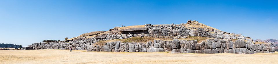
Inca architecture is renowned for its monumental stone masonry, which achieved extraordinary precision without the use of mortar, iron tools, or the wheel.1, 13 The finest Inca stonework employed ashlar construction in which individual blocks of andesite or limestone were shaped by pounding with harder stone hammers and then ground against one another until they fitted together with seams so tight that a knife blade cannot be inserted between them.1 The fortress of Sacsayhuamán, overlooking Cusco, features zigzag walls built of limestone blocks weighing up to 130 tonnes, fitted together without mortar in a polygonal style that has withstood five centuries of earthquakes in one of the world's most seismically active regions.1
Machu Picchu, perched on a narrow ridge at 2,430 metres above sea level between the Urubamba River gorge and the peak of Huayna Picchu, is the most celebrated example of Inca architectural and engineering achievement.13 AMS radiocarbon dating of human remains from the site indicates that construction began around 1420 CE, during the reign of Pachacuti, who built it as a royal estate and ceremonial retreat.13 The site comprises approximately 200 structures including temples, residences, storehouses, and fountains, integrated with an elaborate system of agricultural terraces and drainage channels that stabilise the steep terrain and manage the 2,000 millimetres of annual rainfall.1, 13 The Intihuatana stone, a carved granite pillar at the site's highest point, functioned as an astronomical observation post aligned with the sun's position during the solstices, reflecting the centrality of solar worship to Inca religion and calendrical practice.1
Inca hydraulic engineering was equally sophisticated. The capital city of Cusco was built at the confluence of two canalised rivers, the Saphi and the Tullumayo, whose channels were lined with stone and ran beneath the city's streets, providing fresh water and drainage.1 At the agricultural experimental site of Moray, concentric circular terraces descending into natural sinkholes created temperature differentials of up to 15°C between the highest and lowest levels, which may have been used to test crop varieties at simulated altitudes — an Andean agricultural laboratory.1
Religion and ritual practice
Inca religion was a complex system of state-sponsored and local cults centred on the worship of Inti, the sun god, from whom the Sapa Inca claimed direct descent.1, 19 The principal temple in Cusco, the Qorikancha ("golden enclosure"), was dedicated to Inti and reportedly featured interior walls sheathed in gold plate, a golden sun disc, and a garden of life-sized gold and silver replicas of maize plants, llamas, and other offerings.1, 19 The creator deity Viracocha, conceived as the originator of all things who had fashioned humanity from clay at Tiwanaku, occupied a supreme but somewhat abstract position in the Inca pantheon, while other celestial bodies, weather phenomena, and landscape features (huacas) were venerated through a system of sacred sight lines (ceques) radiating from Cusco.19, 1
The most dramatic expression of Inca state religion was the capacocha ceremony, a ritual of human sacrifice in which children selected for their physical perfection were brought to Cusco from across the empire, paraded in elaborate ceremonies, and then taken to high mountain summits where they were killed as offerings to the mountain deities and the sun.15, 16, 17 The remarkably preserved frozen mummies of three children discovered at the summit of Llullaillaco (6,739 metres) in northwestern Argentina in 1999 have provided extraordinary bioarchaeological evidence for the capacocha ritual.15, 17 Stable isotope analysis of the children's hair revealed a dramatic escalation in coca leaf and maize beer (chicha) consumption in the twelve months preceding their deaths, interpreted as a deliberate programme of ritual preparation and sedation.15 The eldest child, a girl of approximately thirteen years, showed evidence of having been selected from a peasant community and elevated to elite status through dietary changes, textile upgrades, and ritual activities over a period of at least a year before her sacrifice.15, 16
María Constanza Ceruti's survey of high-altitude archaeological sites across the Andes has documented capacocha offerings on at least sixteen peaks above 5,000 metres, demonstrating that the ritual was conducted throughout the empire and required extraordinary logistical commitment, including the construction of ceremonial platforms, staircases, and supply stations at extreme elevations.17 The capacocha functioned as a mechanism of political integration: by drawing sacrificial children from provincial communities and returning sacred objects to local shrines, the ritual created bonds of obligation and reciprocity between the imperial centre and its periphery.1, 17
The Spanish conquest and the fall of Tawantinsuyu
The Inca Empire was fatally weakened before the first Spaniard set foot within its borders. The death of Huayna Capac around 1527, likely from a smallpox or measles epidemic that had spread southward from Central America ahead of direct European contact, precipitated a civil war between his sons Atahualpa, who controlled the northern armies based in Quito, and Huascar, who held the capital at Cusco.1, 4 Atahualpa's forces defeated and captured Huascar in 1532, but the war had devastated the empire's military capacity, fractured elite loyalties, and left provincial populations resentful of the violence inflicted by both sides.4
Francisco Pizarro arrived on the Peruvian coast with fewer than 170 men and 62 horses in early 1532, at the precise moment of Atahualpa's victory.4, 1 At Cajamarca on 16 November 1532, Pizarro's small force ambushed Atahualpa's retinue of several thousand unarmed attendants in the town square, killing an estimated 2,000 to 6,000 Inca in a matter of hours and capturing the emperor himself — a catastrophic decapitation strike that paralysed the empire's centralised command structure.4 Atahualpa offered an enormous ransom — a room filled with gold and twice with silver — which the Spanish collected over the following months before executing him in July 1533 on charges of treason and idolatry.1, 4
The Spanish marched on Cusco and captured it in November 1533, installing a puppet Inca ruler, Manco Inca, who initially cooperated before launching a massive but ultimately unsuccessful siege of the city in 1536.4 Manco Inca retreated to the remote mountain fortress of Vilcabamba, where a rump Inca state survived until 1572, when the last Inca emperor, Tupac Amaru, was captured and publicly beheaded in Cusco by order of the Spanish viceroy Francisco de Toledo.4, 1 The conquest was facilitated not only by Spanish military technology — steel weapons, firearms, horses, and war dogs — but critically by the alliances Pizarro forged with ethnic groups who had chafed under Inca domination, and by the catastrophic demographic collapse caused by Old World diseases to which Andean populations had no immunity.4, 1
Legacy and archaeological significance
The Inca Empire holds a central place in the comparative study of early states and empires. As the only primary state to develop in the Americas south of Mesoamerica, Tawantinsuyu offers an independent case study in the processes of state formation, imperial expansion, and administrative complexity that can be compared with Old World empires without the complication of shared cultural heritage.1, 12 The Inca achievement of governing millions of people across one of the world's most geographically challenging environments without a market economy, writing (in the conventional sense), or wheeled transport challenges fundamental assumptions about the prerequisites for complex state organisation derived primarily from Mesopotamian and Mediterranean precedents.1, 6
The Qhapaq Ñan road network, recognised by UNESCO in 2014, remains partially in use in rural Andean communities and has become a focus of international heritage conservation efforts across six nations.21 The ongoing decipherment of khipu continues to generate new insights into Inca administration, with each new archive discovery — such as the Inkawasi collection and the Collata epistolary khipu — expanding understanding of the system's informational capacity.8, 9, 10 Quechua, the language of the Inca administration, remains spoken by approximately 8 to 10 million people across Peru, Bolivia, Ecuador, and neighbouring countries, and Inca agricultural technologies — terracing, freeze-drying, and the cultivation of thousands of potato varieties — continue to sustain highland communities and inform contemporary approaches to food security in mountain environments.1, 18
For anthropology, the Inca case illuminates the diverse pathways by which human societies have organised political authority, economic production, and information management at scale.1, 12 The empire's reliance on labour rather than commodity taxation, its use of ecological complementarity across vertical zones as an organising principle, and its development of a recording technology without parallel in the global archaeological record all demonstrate that the trajectory of state complexity followed by Western Eurasian civilisations was one possibility among many, not a universal template.1, 6, 3
References
How the Incas Built Their Heartland: State Formation and the Innovation of Imperial Strategies in the Sacred Valley, Peru
Khipu Archives: Duplicate Accounts and Identity Labels in the Inka Knotted String Records
Archaeological, Radiological, and Biological Evidence Offer Insight into Inca Child Sacrifice
Frozen Mummies from Andean Mountaintop Shrines: Bioarchaeology and Ethnohistory of Inca Human Sacrifice
Beyond Inca Roads: Archaeological Mobilities from the High Andes to the Pacific in Southern Peru