Overview
- Tiwanaku was a major pre-Columbian polity centred near the southern shore of Lake Titicaca in modern Bolivia, flourishing from approximately 500 to 1000 CE and exerting political, economic, and ideological influence across an estimated 400,000 square kilometres of the south-central Andes.
- The city of Tiwanaku, situated at roughly 3,850 metres above sea level, housed an estimated 10,000 to 20,000 inhabitants at its peak and featured monumental stone architecture — including the Akapana pyramid, the Kalasasaya platform, and the Semi-Subterranean Temple — that served as the ceremonial and administrative heart of the state.
- Bayesian radiocarbon modelling of 102 dates indicates that Tiwanaku's urban collapse occurred rapidly around 1010–1050 CE, preceding major regional drought, suggesting that internal social and political factors rather than climate alone drove the disintegration of the state.
Tiwanaku (also spelled Tiahuanaco) was a pre-Columbian polity and urban centre situated near the southern shore of Lake Titicaca on the Bolivian altiplano, at an elevation of approximately 3,850 metres above sea level.1, 13 From roughly 500 to 1000 CE, the Tiwanaku state exerted political, economic, and ideological influence across an estimated 400,000 square kilometres of the south-central Andes, encompassing portions of modern Bolivia, southern Peru, northern Chile, and northwestern Argentina.2, 12 The city itself was one of the highest-altitude urban centres in the ancient world, home to an estimated 10,000 to 20,000 people at its apogee, and its monumental architecture — massive stone platforms, sunken courts, and elaborately carved monoliths — made it one of the most important ceremonial centres in pre-Columbian South America.1, 4 Tiwanaku's influence extended far beyond its geographic heartland through a combination of colonial settlements, trade networks, and a distinctive religious iconography centred on the Staff God motif, which spread across the Andes and profoundly shaped the cultural landscape of the region for centuries before the rise of the Inca Empire.2, 9
Environment and origins
The Lake Titicaca Basin, straddling the modern border of Bolivia and Peru at approximately 3,810 metres above sea level, is one of the highest habitable regions on Earth and provided the environmental context for Tiwanaku's emergence.3, 12 The lake itself — covering roughly 8,400 square kilometres — acts as a thermal reservoir, moderating temperatures in adjacent areas and creating a microclimate capable of supporting agriculture in a zone that would otherwise be too cold for most crops.3 Early agropastoral communities in the basin cultivated frost-resistant tubers such as potatoes and oca, along with chenopod grains including quinoa, and herded camelids (llamas and alpacas) from at least the second millennium BCE.12
The earliest occupation at the site of Tiwanaku dates to the Late Formative period. A Bayesian reassessment of the earliest radiocarbon dates from the site estimates its founding at approximately 110 CE (50–170 CE at 68% probability), though significant urban growth did not occur until several centuries later.14 During the Formative period (roughly 1500 BCE–500 CE), several competing polities emerged around Lake Titicaca, including Chiripa on the southern lakeshore and Pukara in the northern basin, each developing distinctive ceremonial architecture and craft traditions.12, 21 Tiwanaku gradually eclipsed these rivals, and by approximately 500 CE it had consolidated control over the southern Titicaca Basin and begun to transform itself into a monumental urban centre with a resident population drawn from multiple ethnic communities.1, 2
Monumental architecture and urban design
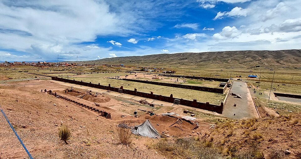
The civic-ceremonial core of Tiwanaku covered approximately 4 square kilometres and was dominated by a series of massive stone constructions that served simultaneously as temples, administrative facilities, and symbolic statements of state power.1, 13 The Akapana, the largest structure at the site, is a terraced platform mound roughly 200 metres on a side and originally standing approximately 17 metres high, faced with precisely cut andesite and sandstone blocks and shaped in the form of an Andean cross when viewed from above.1, 4 The Akapana contained an elaborate internal drainage system of stone-lined channels that collected rainwater from a sunken court on its summit and directed it downward through the structure's interior, creating the visual and auditory effect of water flowing through a sacred mountain — a potent cosmological symbol in Andean thought.4
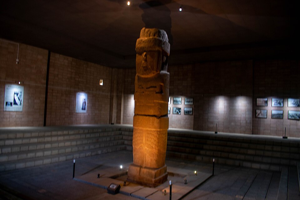
North of the Akapana lies the Kalasasaya, a large rectangular enclosure measuring approximately 120 by 130 metres, bounded by tall sandstone pillars and functioning as both an astronomical observatory and a ceremonial platform.1, 13 The Kalasasaya's walls are aligned so that the rising sun on the equinoxes and solstices is framed by specific gateways, indicating that the structure served calendrical and ritual purposes closely tied to agricultural cycles.1 Within the Kalasasaya stands the Ponce Monolith, a 3.5-metre-tall anthropomorphic stela carved from a single block of andesite, depicting a figure holding a kero (ceremonial drinking vessel) in one hand and a staff-like object in the other, with its torso covered in elaborate iconographic motifs.17
Adjacent to the Kalasasaya is the Semi-Subterranean Temple (Templete Semisubterráneo), a square sunken courtyard approximately 28 metres on a side, with walls adorned by tenon heads carved in diverse styles — possibly representing different ethnic groups incorporated into the Tiwanaku polity.1, 11 It was within this structure that the American archaeologist Wendell Bennett in 1932 excavated the massive Bennett Monolith, a 7.3-metre-tall red sandstone stela depicting a richly attired figure whose body is covered with images of running bird-headed beings, llamas, and the frontal Staff God motif also found on the Gateway of the Sun.17 To the southeast of the main civic core lies Pumapunku, a separate temple complex featuring some of the most precisely cut stonework in the ancient Americas, with interlocking blocks of andesite and diorite fitted together without mortar to tolerances of fractions of a millimetre.4, 5
Iconography and religion
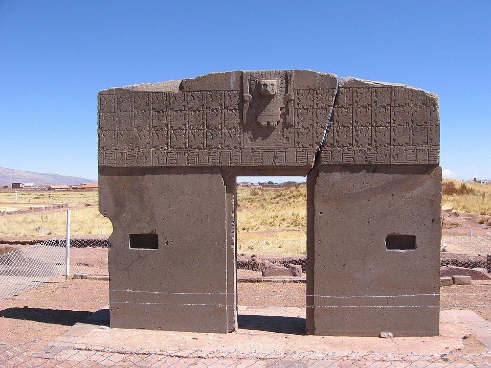
Tiwanaku's religious system is known primarily through its monumental stone carvings, painted ceramics, and textile iconography, all of which share a coherent symbolic vocabulary dominated by the Staff God (also called the Front-Facing Deity).19, 1 The most famous representation of this figure appears on the Gateway of the Sun, a monolithic andesite doorway originally located at Pumapunku or the Kalasasaya, which depicts a central frontal figure standing on a stepped platform, wearing an elaborate headdress with rays terminating in animal heads and circular discs, and holding a staff in each hand.19, 13 Flanking this central figure are rows of profile attendants — winged beings with human or avian heads, sometimes called "angels" or "running figures" — who face inward toward the deity in postures of deference.19
Analysis of the carved imagery across multiple monoliths and gateways reveals a structured iconographic programme in which the Staff God occupied the apex of a cosmic hierarchy, with subsidiary figures arranged in spatial configurations that reflected relationships of power, subordination, and ritual function.19 The Bennett and Ponce monoliths, studied from a multispecies perspective, depict not only human-like figures but also a rich bestiary of condors, pumas, camelids, serpents, and fish — animals associated with the three vertical ecological zones of Andean cosmology: the sky (hanan pacha), the earth (kay pacha), and the underworld (ukhu pacha).17 The presence of psychoactive snuff tablets and tubes in Tiwanaku burials, along with depictions of figures with streaming nasal discharge on ceramic vessels, suggests that hallucinogenic substances — likely derived from Anadenanthera seeds — played a significant role in religious practice and were probably consumed by ritual specialists as part of ceremonies conducted at the monumental temples.1, 11
Underwater archaeological excavations near the Island of the Sun in Lake Titicaca have recovered gold, shell, and lapidary offerings along with sacrificed juvenile llamas dating to the eighth through tenth centuries CE, demonstrating that the Tiwanaku state invested heavily in ritual activity at sacred locations within the lake itself.10 These offerings were deposited on a submerged reef at a location visible from the island's summit, suggesting a carefully orchestrated programme of ritual deposition designed to reinforce the state's ideological authority over this cosmologically significant body of water.10
Agriculture and raised fields
The economic foundation of the Tiwanaku state rested on intensive agriculture in the floodplains surrounding Lake Titicaca, supplemented by camelid herding on the higher grasslands of the altiplano.3, 6 The most distinctive agricultural innovation associated with Tiwanaku was the system of raised fields (suka kollus in Aymara), elevated planting platforms separated by water-filled canals that together covered tens of thousands of hectares in the lake's southern basin.6, 18
Alan Kolata's pioneering research demonstrated that the raised fields functioned as a sophisticated thermal engineering system adapted to the extreme conditions of high-altitude agriculture.6, 18 The water-filled canals absorbed solar radiation during the day and released stored heat at night, creating a microclimate around the raised planting surfaces that protected crops from the devastating frosts that regularly occur on the altiplano, where nighttime temperatures can drop below −5°C even during the growing season.18, 7 Recent fluid and thermal analysis has confirmed that the canals' thermal mass was sufficient to raise nocturnal air temperatures above the planting surface by 2–3°C relative to surrounding unmodified terrain, providing a critical margin of frost protection for temperature-sensitive crops.7
Beyond thermal regulation, the canals served as biological reactors: aquatic plants and algae growing in the water fixed atmospheric nitrogen, and when canal sediments were periodically dredged and applied to the raised surfaces, they provided a rich organic fertiliser that sustained soil fertility over long periods without the need for fallow rotations.6, 3 This system enabled the production of agricultural surpluses at an altitude where conventional farming would yield only marginal returns, and Kolata argued that the state's capacity to organise and maintain raised-field agriculture on a massive scale was fundamental to its political authority and demographic growth.6
Estimated raised-field coverage in the southern Titicaca Basin by period6, 3
Political organisation and state expansion
The nature of the Tiwanaku state — whether it constituted a centralised empire, a decentralised confederation, or something without easy analogy in Western political typologies — has been one of the most debated questions in Andean archaeology.2, 21 Charles Stanish argued that Tiwanaku represented a form of archaic state in which political authority was closely intertwined with religious ideology, and that the state's expansion relied less on military conquest than on the dissemination of a compelling ritual complex centred on the Staff God iconography and associated with pilgrimage, feasting, and prestige-goods exchange.21, 12 John Wayne Janusek, by contrast, emphasised the multiethnic character of the Tiwanaku capital itself, arguing that the city functioned as a cosmopolitan centre where diverse communities maintained distinct residential quarters, craft traditions, and mortuary practices while participating in shared ceremonial activities at the monumental core.11, 1
The Tiwanaku state expanded its influence through a combination of mechanisms that varied by region. In the altiplano heartland, the state appears to have exercised relatively direct administrative control, organising labour for raised-field agriculture and monumental construction through systems that may have prefigured the mit'a labour tax later formalised by the Inca.6, 2 In more distant regions, Tiwanaku established colonial enclaves — most notably in the Moquegua Valley of southern Peru, some 300 kilometres from the capital — where migrant populations from the altiplano settled at lower elevations to cultivate maize, peppers, and other warm-climate crops unavailable in the Titicaca Basin.8, 9
Paul Goldstein's excavations at the Omo site complex in Moquegua revealed a full-scale Tiwanaku temple with sunken-court architecture replicating the ceremonial forms of the capital — the only such structure known outside the Titicaca Basin — along with residential areas, cemeteries, and agricultural terraces indicating a permanent, self-sustaining colonial community rather than a mere trading post.8 Strontium isotope and oxygen isotope analyses of human remains from Omo M10 have demonstrated that first-generation migrants from the altiplano constituted a significant proportion of the colonial population, confirming that Tiwanaku expansion involved actual demographic movement rather than solely the diffusion of material culture.20 Recent discoveries at Palaspata, approximately 215 kilometres southeast of the capital in the Caracollo municipality of Oruro, have revealed a previously unknown Tiwanaku temple complex that extends the known range of state-sponsored monumental construction and suggests a southeastern axis of expansion not previously documented.16
Society and identity
Archaeological evidence from residential areas within and around Tiwanaku indicates a socially stratified but ethnically diverse urban community.11, 1 Excavations in neighbourhoods such as Akapana East and Ch'iji Jawira have revealed distinct clusters of households differentiated by their ceramic assemblages, dietary remains, architectural styles, and mortuary practices — patterns that Janusek interpreted as evidence of ethnically distinct residential wards (barrios) occupied by communities that migrated to the capital from different parts of the Titicaca Basin and beyond.11 Despite these differences, all communities participated in feasting events centred on the consumption of chicha (maize beer) served in decorated keros and tazones (large drinking vessels), suggesting that shared ritual drinking was a key mechanism of social integration across ethnic boundaries.1, 11
Craft production was organised along neighbourhood lines, with different barrios specialising in distinct goods: some quarters concentrated on ceramic production, others on textile weaving, and still others on the working of bone, stone, or metal.11 This spatial organisation of craft specialisation suggests that ethnic identity and occupational identity were closely linked in Tiwanaku society, and that the state drew upon the productive capacities of diverse communities rather than imposing a single homogeneous cultural template.11, 2 Artificial cranial deformation — the intentional reshaping of infant skulls through binding — was practised in Tiwanaku and its colonies, with distinct deformation styles corresponding to different social or ethnic groups, indicating that embodied markers of identity were important in structuring social relations within the polity.20
Collapse and abandonment
The collapse of Tiwanaku has been the subject of intense scholarly debate, with competing hypotheses centring on climatic deterioration, internal political fragmentation, or some combination of both.5, 15 Alan Kolata originally proposed that a prolonged drought beginning around 1000 CE lowered Lake Titicaca's water levels, rendered the raised-field system unviable, and thereby undermined the agricultural surplus upon which the state depended.3 Palaeoclimatic evidence from lake sediment cores, including data from Lake Orurillo in southern Peru, has confirmed that a significant period of aridity occurred between approximately 900 and 1100 CE, with reduced precipitation and lower lake stands recorded across the south-central Andes.15
However, a 2023 Bayesian chronological analysis by Erik Marsh, John Wayne Janusek, and Maria Bruno, based on 102 radiocarbon dates (including 45 previously unpublished), has significantly refined the timeline of Tiwanaku's decline and challenged the drought hypothesis as a primary explanation.5 This study demonstrated that monumental construction at Tiwanaku ceased around 720 CE, roughly two centuries before the urban collapse itself.5 Burials in formal tombs ended around 910 CE, at which point evidence of violent deaths and ritualised killings appeared in the archaeological record, persisting for approximately a century.5 The end of permanent urban residence is estimated at approximately 1010 CE (970–1050 CE at 95% probability), representing a rapid abandonment that unfolded over as few as 20 years.5
Crucially, this chronology places the city's collapse before the most severe phase of regional drought, suggesting that the abandonment of Tiwanaku was driven primarily by internal social and political processes — possibly intensifying factionalism, elite competition, and inter-community violence — rather than by environmental deterioration alone.5 The evidence of a century of ritualised violence preceding the final collapse suggests a period of increasing social stress and political instability during which the institutions that had held the multiethnic polity together progressively failed.5, 1 After the abandonment of the urban core, the raised-field systems were largely abandoned within two centuries, and the Titicaca Basin fragmented into a series of competing chiefdoms (señoríos aymaras) that persisted until their incorporation into the Inca Empire in the fifteenth century.12, 2
Legacy and archaeological significance
Tiwanaku was inscribed as a UNESCO World Heritage Site in 2000, recognised as a spiritual and political centre that "provides exceptional testimony to the power of the empire that played a leading role in the development of pre-Columbian civilisation in the Andean region."13 The site has been the subject of systematic archaeological investigation since the mid-twentieth century, beginning with the Bolivian archaeologist Carlos Ponce Sanginés, who directed extensive excavations and restorations from the 1950s through the 1980s, followed by Alan Kolata's multidisciplinary projects from the late 1970s through the 1990s and Janusek's ongoing research programme.4, 1
Tiwanaku's influence on subsequent Andean civilisations was profound. The Staff God iconography that originated at Tiwanaku (and possibly at earlier Formative-period sites such as Chiripa) spread across a vast area of the central and southern Andes during the Middle Horizon (approximately 600–1000 CE), transmitted in part through the contemporaneous Wari state in the central Peruvian highlands, which adopted and modified Tiwanaku religious imagery.19, 2 The Inca, who rose to power in the Cusco region some four centuries after Tiwanaku's collapse, explicitly claimed Tiwanaku and Lake Titicaca as the place of origin of the sun and the mythological birthplace of the first Inca rulers, incorporating Tiwanaku's monumental ruins into their own legitimising narratives and thereby acknowledging the enduring prestige of the earlier civilisation.12 Modern experimental reconstructions of Tiwanaku raised fields have demonstrated that the ancient agricultural technology remains viable, with restored suka kollus producing significantly higher yields than conventional altiplano farming methods — a finding with practical implications for contemporary food security in the high Andes.7, 18
References
Tiwanaku and Its Hinterland: Archaeology and Paleoecology of an Andean Civilization, Volume 1: Agroecology
Tiwanaku and Its Hinterland: Archaeology and Paleoecology of an Andean Civilization, Volume 2: Urban and Rural Archaeology
Fluid and Thermal Analysis of Pre-Columbian Tiwanaku (500–1100 CE) Raised-Field Agricultural Systems of Bolivia
Tiwanaku Temples and State Expansion: A Tiwanaku Sunken-Court Temple in Moquegua, Peru
Multiethnicity, pluralism, and migration in the south central Andes: An alternate path to state expansion
Underwater ritual offerings in the Island of the Sun and the formation of the Tiwanaku state
Ancient Titicaca: The Evolution of Social Complexity in Southern Peru and Northern Bolivia
Drought and the collapse of the Tiwanaku Civilization: New evidence from Lake Orurillo, Peru
Gateway to the east: The Palaspata temple and the south-eastern expansion of the Tiwanaku state
Drunken Mountains: Analysis of the Bennett and Ponce Monoliths of Tiwanaku (AD 500–1100) from a Multispecies Perspective
Thermal Analysis of Tiwanaku Raised Field Systems in the Lake Titicaca Basin of Bolivia
Spatial Configuration in Tiwanaku Art: A Review of Stone Carved Imagery and Staff Gods
Migration scale, process, and impact in the Tiwanaku colonies: Paleomobility at the archaeological site of Omo M10