Overview
- The Zapotec civilization (c. 700 BCE–1521 CE) arose in the Valley of Oaxaca in southern Mexico and established Monte Albán around 500 BCE as one of Mesoamerica’s earliest urban centres, growing to a population of approximately 17,000–25,000 at its Classic-period peak and controlling a territory spanning much of the Oaxacan highlands.
- The Zapotecs developed one of Mesoamerica’s earliest writing systems by at least 600 BCE, created a sophisticated 260-day ritual calendar (the piye), built architecturally complex civic-ceremonial centres featuring platform mounds, a ball court, and the astronomically oriented Building J, and practised elaborate tomb burial with painted murals and ceramic effigy urns.
- Monte Albán declined as a political capital after approximately 700 CE amid regional fragmentation and the rise of competing valley polities; the site was later reused by Mixtec elites, most famously in Tomb 7, where Alfonso Caso discovered over 500 gold, jade, and turquoise artefacts in 1932—one of the richest pre-Columbian burials ever excavated.
The Zapotec civilization was one of the earliest complex societies in Mesoamerica, flourishing in the Valley of Oaxaca in what is now southern Mexico from approximately 700 BCE to the Spanish conquest in 1521 CE.1, 2 The Zapotecs—who called themselves Ben’Zaa, or “Cloud People”—built their capital at Monte Albán, a ridgetop site overlooking the convergence of the valley’s three arms, which by the Classic period (c. 200–700 CE) had grown into a city of an estimated 17,000–25,000 inhabitants and the centre of a state controlling much of the Oaxacan highlands.1, 3, 17 Designated a UNESCO World Heritage Site in 1987, Monte Albán and the broader Zapotec tradition are recognised for producing one of the earliest writing systems in the Americas, a sophisticated 260-day ritual calendar, monumental civic-ceremonial architecture, and elaborate mortuary practices that illuminate the social and political organisation of an indigenous American state.7, 8 The Zapotec case has also served as a foundational example in the comparative study of state formation, offering one of the most thoroughly documented archaeological sequences of how village societies transformed into urban, hierarchical polities over a span of more than a millennium.1, 4
Origins in the Valley of Oaxaca
The Valley of Oaxaca is a Y-shaped highland basin in southern Mexico, formed by the convergence of three sub-valleys—Etla to the northwest, Tlacolula to the east, and Zimatlán-Ocotlán to the south—at an elevation of approximately 1,550 metres above sea level.1, 3 This semi-arid but agriculturally productive landscape, watered by the Atoyac River and its tributaries, supported permanent farming communities from at least 1500 BCE, when villages such as San José Mogote in the Etla arm began cultivating maize, beans, and squash alongside wild plant foods.5, 1 San José Mogote grew to become the largest settlement in the valley during the Early and Middle Formative periods (c. 1500–700 BCE), covering as much as 70 hectares by the Rosario phase (c. 700–500 BCE) and exhibiting public architecture, craft specialisation in magnetite mirror production, and evidence of hereditary social ranking.5, 15
Archaeological excavations by Kent Flannery and Joyce Marcus revealed that by the Rosario phase the Valley of Oaxaca was divided among at least three competing chiefdom-level polities, each centred on a principal village: San José Mogote in the Etla valley, Yegüih in the Tlacolula valley, and San Martín Tilcajete in the southern valley, separated by a buffer zone of approximately 80 square kilometres of unoccupied land.1, 6 Conflict between these polities intensified during the late Rosario phase, as evidenced by the burning of San José Mogote’s main temple and the carving of Monument 3, which depicts a slain enemy captive and bears one of the earliest securely dated Zapotec hieroglyphic inscriptions (c. 600 BCE).6, 15 Around 500 BCE, approximately 2,000 people from San José Mogote and its satellite communities relocated to the previously uninhabited mountaintop that would become Monte Albán, an event that Flannery and Marcus interpret as a deliberate political act of synoikism—the unification of rival populations into a single defensible centre.1, 9
The founding and growth of Monte Albán
.jpg)
.jpg)
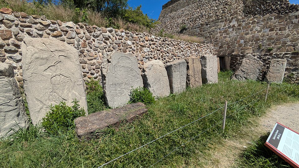
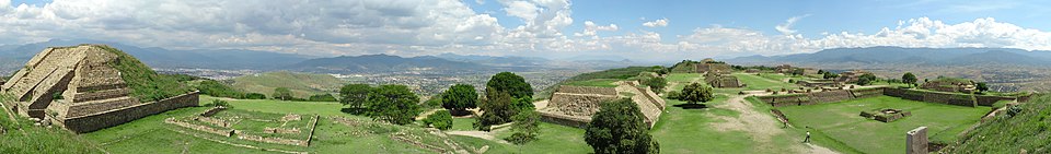
Monte Albán was established on a 400-metre-high ridgetop at the junction of the valley’s three arms, a location that offered both strategic defensibility and symbolic centrality.1, 16 The earliest phase of occupation, Monte Albán Early I (c. 500–300 BCE), saw the rapid construction of a three-kilometre-long defensive wall on the mountain’s more accessible western slopes and the laying out of the Main Plaza, a massive levelled terrace approximately 300 metres long and 150 metres wide that would serve as the civic-ceremonial core of the city for over a thousand years.1, 3 During this initial phase, the population grew from the founding group of roughly 2,000 to an estimated 5,000 inhabitants, accompanied by the construction of the earliest monumental structures, including the gallery of carved stone slabs known as the Danzantes.1, 7
The Danzantes (“dancers”)—a misnomer from early interpretations of their contorted postures—are more than 300 carved stone slabs depicting naked, often mutilated human figures now understood to represent sacrificed war captives.7, 1 Many bear hieroglyphic name-glyphs and calendrical notations, making them some of the earliest examples of writing and calendrical recording in Mesoamerica.7, 18 Their prominent display on a public building at the heart of the new capital served as a monumental statement of military power, advertising Monte Albán’s dominance over conquered enemies during the period of valley unification.1, 7
By Monte Albán II (c. 100 BCE–200 CE), the city had consolidated control over the entire Valley of Oaxaca and begun expanding its influence beyond the valley through a combination of military conquest and diplomatic exchange.1, 19 Building J, an arrow-shaped structure set at an angle to the Main Plaza’s cardinal grid, was constructed during this phase; its walls bear approximately 50 carved “conquest slabs” depicting place-glyphs of subjugated communities, documenting the geographic scope of Monte Albán’s territorial expansion.1, 16 The city reached its maximum size and political influence during the Classic period (Monte Albán IIIA and IIIB, c. 200–700 CE), when its population is estimated to have reached 17,000–25,000 and the surrounding valley supported a total population of perhaps 115,000 distributed across more than 1,000 settlements.3, 17
Estimated population growth of Monte Albán1, 3
Writing and the calendar
The Zapotec writing system is among the oldest in the Americas, with its earliest secure examples dating to approximately 600 BCE on Monument 3 at San José Mogote and the Danzantes slabs at Monte Albán.7, 18 Joyce Marcus has argued that during Monte Albán’s Period I the capital held a virtual monopoly on hieroglyphic inscriptions, most of which dealt with themes of sacrificing rival leaders—a pattern she interprets as state propaganda designed to legitimise the new polity’s authority.7 The script is logosyllabic, combining logograms representing whole words or concepts with syllabic signs, and was used to record personal names, calendrical dates, place-names, and genealogical information on stone monuments, painted tomb walls, and ceramic vessels.18, 7
Central to the Zapotec intellectual tradition was the piye, a 260-day ritual calendar composed of 20 named days cycling through 13 numerical coefficients.1, 7 This calendar, shared in structural principle with the broader Mesoamerican 260-day count (known as the tonalpohualli among the Aztecs and the tzolk’in among the Maya), was used for divination, the scheduling of rituals, and the naming of individuals, who received as their personal name the day on which they were born.7, 12 The Zapotecs also employed a 365-day solar calendar (yza) that interlocked with the piye to produce a 52-year Calendar Round, a cycle of fundamental importance in Mesoamerican chronology.1, 7 Javier Urcid’s comprehensive study of Zapotec hieroglyphic inscriptions has identified a corpus of more than 1,400 texts, revealing that the writing system continued to evolve over more than a millennium and was used for an increasingly diverse range of communicative purposes as the state matured.18
Architecture and urban planning
Monte Albán’s Main Plaza is one of the most impressive examples of monumental civic space in pre-Columbian Mesoamerica.1, 8 The plaza was created by levelling the mountaintop and was flanked on its north and south ends by massive platform mounds that supported temples and elite residences, while smaller platforms, altars, and stelae lined the east and west sides.16, 1 The entire architectural programme was oriented to the cardinal directions, with structures aligned to astronomical events that structured the ritual calendar.1, 4
Building J, constructed during Monte Albán II (c. 100 BCE–200 CE), is the most architecturally distinctive structure on the site.1, 16 Its pentagonal, arrow-shaped plan departs from the plaza’s cardinal grid, and its orientation has been interpreted as aligning with the first-magnitude star Capella or with the zenith passage of the sun, events of calendrical significance in Mesoamerican astronomy.4, 16 The building’s interior contains a narrow, zenith-tube-like passage, and its exterior walls are set with more than 40 carved conquest slabs bearing Zapotec place-glyphs, making it simultaneously an astronomical monument and a record of territorial domination.1, 16
The site also features an I-shaped ball court constructed during Phase II, measuring approximately 41 by 24 metres with sloping walls coated in lime plaster.16, 8 Ball courts were central to Mesoamerican ritual life, and Monte Albán’s court, located in the northeast corner of the Main Plaza, reflects the integration of sport, ceremony, and political display that characterised urban centres across the region.1 Residential terraces cascaded down the mountain’s slopes in concentric rings around the monumental core, housing the bulk of the city’s population in adobe and stone dwellings arranged around small patios, a spatial pattern documented through systematic survey by Richard Blanton and his collaborators.3, 17
Religion and cosmology
Zapotec religion centred on a pantheon of deities associated with natural forces, agricultural fertility, and the cardinal directions.1, 12 The most prominent deity was Cocijo, the god of lightning and rain, whose image appears on hundreds of ceramic effigy urns recovered from Zapotec tombs.12 Adam Sellen’s analysis of these urns has demonstrated that Cocijo was depicted with a composite iconographic programme incorporating serpent-like features, a forked tongue representing lightning, and a glyph resembling the Zapotec sign for “water”—attributes that underscore his role as the supernatural force controlling rainfall, the most critical variable in Oaxacan agriculture.12 The Zapotecs divided the 260-day piye calendar into four 65-day periods called cocijos, each associated with a cardinal direction and presided over by a distinct aspect of the lightning deity, reflecting the deep integration of religious cosmology with calendrical structure.12, 7
Zapotec cosmology conceived of the universe as three interconnected realms: the sky, the earth, and the underworld.1, 13 The living occupied the terrestrial plane, while ancestors resided in the underworld, accessible through caves and tombs that served as portals between worlds.1 This cosmological framework is reflected in Monte Albán’s elaborate tomb architecture, where cruciform stone chambers beneath residential platforms were painted with polychrome murals depicting deities, processions, and calendrical signs, transforming the burial space into a symbolic underworld inhabited by the divine.4, 1 The practice of burying the dead beneath domestic floors reinforced the connection between the living household and its ancestral foundation, a pattern that Flannery and Marcus have traced from the earliest Formative villages through to the Classic-period urban centre.5, 1
Political organisation and territorial control
The Zapotec state that emerged at Monte Albán represents one of the earliest examples of archaic state formation in the Americas, and its political structure has been the subject of extensive theoretical debate.1, 2 Flannery and Marcus have argued that the Monte Albán polity was organised as a centralised state with a paramount ruler and a multi-tiered administrative hierarchy, in which secondary and tertiary centres in the surrounding valley were subordinate to the capital through tribute obligations, military garrisons, and the placement of carved stone monuments bearing the capital’s iconography.1, 19 Spencer and Redmond’s excavations at the secondary centre of El Palenque in the Cuicatlán Cañada have documented evidence of Monte Albán’s military expansion beyond the Valley of Oaxaca during the Late Formative period, including the construction of a skull rack (tzompantli) and the establishment of a colonial administrative centre staffed by personnel from the capital.19
Settlement pattern surveys conducted by Blanton, Kowalewski, and their collaborators have revealed a four-tier site-size hierarchy in the Classic-period valley, with Monte Albán at the apex, followed by secondary centres of 2,000–5,000 people, tertiary communities of several hundred, and small hamlets and farmsteads at the base.3, 17, 20 This settlement hierarchy, combined with the standardisation of ceramic types, architectural forms, and iconographic programmes across the valley, has been interpreted as evidence of a politically integrated territorial state rather than a loose confederation of autonomous communities.2, 3 At its maximum extent during Monte Albán II and IIIA, the Zapotec state’s sphere of influence extended well beyond the Valley of Oaxaca into the Cuicatlán Cañada to the north, the Mixteca Alta to the west, and portions of the Pacific coastal lowlands to the south, though the degree of direct political control exercised over these peripheral regions remains debated.1, 19
Decline and political fragmentation
Monte Albán’s decline as a political capital was a gradual process that unfolded over approximately two centuries, beginning in the late Classic period (c. 500–700 CE) and resulting in the effective abandonment of the mountaintop as a residential centre by approximately 900 CE.2, 11 The causes of this decline remain a subject of scholarly debate, but several interrelated factors have been proposed: the breakdown of the tribute system that sustained the capital’s non-agricultural population, ecological degradation from centuries of intensive hillside farming, and the rising power of secondary centres that had grown large enough to challenge Monte Albán’s political authority.2, 10 The collapse of Monte Albán coincided broadly with upheavals elsewhere in Mesoamerica, including the decline of Teotihuacan in central Mexico and the Classic Maya collapse in the lowlands, suggesting that region-wide systemic factors may have contributed to political instability.2, 13
Rather than signalling the end of Zapotec civilisation, the decline of Monte Albán inaugurated a period of political fragmentation in which power devolved to a series of smaller, competing polities scattered across the Valley of Oaxaca and its surrounding regions.10, 11 Ronald Faulseit’s research has demonstrated that while elite political structures collapsed, ordinary households in the valley showed remarkable resilience, maintaining agricultural production, craft activities, and local exchange networks through the transition.11 During the Postclassic period (c. 900–1521 CE), the Valley of Oaxaca was divided among numerous small Zapotec kingdoms (yetze) and increasingly contested by Mixtec polities expanding from the highlands to the west, producing a complex mosaic of ethnic and political affiliations that persisted until the Spanish conquest.10, 13
Tomb 7 and Mixtec reuse
Although Monte Albán ceased to function as a living city, the site retained profound ceremonial significance for both Zapotec and Mixtec peoples into the Postclassic period.10, 14 The most dramatic evidence of this continued reverence is Tomb 7, a Classic-period Zapotec burial chamber that was reopened and reused by Mixtec elites sometime around the fourteenth century CE.14, 16 The tomb was discovered in January 1932 by the Mexican archaeologist Alfonso Caso, and its contents constituted one of the richest pre-Columbian burials ever excavated: more than 500 artefacts of gold, silver, turquoise, jade, jet, bone, shell, and pearl, including elaborate gold pectorals, necklaces, rings, and a human skull encrusted with turquoise mosaic.14, 16
Archaeometallurgical analysis of the gold and silver artefacts from Tomb 7 has revealed sophisticated metalworking techniques, including lost-wax casting, filigree, and the production of silver–gold alloy foils of remarkable thinness and uniformity.14 The Mixtec were among the most accomplished goldsmiths in pre-Columbian Mesoamerica, and the Tomb 7 assemblage demonstrates their mastery of metallurgical traditions that had been introduced to Mesoamerica from South America via maritime and overland routes during the early Postclassic period.14, 13 The reuse of a Zapotec tomb by Mixtec elites also illustrates the complex cultural dynamics of Postclassic Oaxaca, in which the prestige and sacred associations of Monte Albán transcended ethnic and political boundaries.10, 14
Legacy and modern significance
The Zapotec civilisation left an enduring legacy that extends far beyond the archaeological record.8, 13 Today, the Zapotec people remain one of Mexico’s largest indigenous groups, with approximately 500,000 speakers of Zapotec languages inhabiting the Valley of Oaxaca and the surrounding Sierra Norte and Sierra Sur regions.13 Many contemporary Zapotec communities maintain cultural practices—including weaving traditions, ceramic production, and agricultural rituals—that demonstrate continuity with their pre-Columbian heritage, even as they have integrated elements of Spanish colonial and modern Mexican culture over the past five centuries.13, 1
Monte Albán itself has served as both a national symbol and an anchor for cultural identity.8 Its inscription as a UNESCO World Heritage Site in 1987, alongside the Historic Centre of Oaxaca, recognised the site’s “outstanding universal value” as a testament to the artistic, architectural, and intellectual achievements of Mesoamerican civilisation.8 In the broader history of archaeology, the decades-long research programmes conducted in the Valley of Oaxaca by Flannery, Marcus, Blanton, Kowalewski, and their collaborators have established Zapotec state formation as one of the best-documented case studies for understanding how complex societies emerge from simpler ones—a theoretical contribution that continues to inform comparative analyses of early states from Mesopotamia to the Andes.1, 2, 20
References
Origin and Collapse of Complex Societies in Oaxaca (Mexico): Evaluating the Era from 1965 to the Present
Monte Albán’s Hinterland, Part I: The Prehispanic Settlement Patterns of the Central and Southern Parts of the Valley of Oaxaca, Mexico
Mesoamerican Writing Systems: Propaganda, Myth, and History in Four Ancient Civilizations
An Archaeometallurgical Study of Mixtec Silver–Gold Alloy Foils from Tomb No. 7, Monte Alban, Oaxaca, México
Monte Albán’s Hinterland, Part II: Prehispanic Settlement Patterns in Tlacolula, Etla, and Ocotlán, the Valley of Oaxaca, Mexico