Overview
- Megathrust earthquakes are the most powerful seismic events on Earth, generated by sudden slip on the shallow-dipping fault interface where one tectonic plate subducts beneath another — all recorded earthquakes of magnitude 9.0 or greater, including the 1960 Chile, 1964 Alaska, 2004 Sumatra, and 2011 Tohoku events, occurred on subduction megathrusts.
- These earthquakes rupture fault areas hundreds of kilometres long and tens of kilometres wide, producing minutes-long shaking, metres of vertical seafloor displacement, and devastating transoceanic tsunamis that can cause destruction thousands of kilometres from the epicentre.
- Paleoseismological studies of coastal land-level changes, tsunami deposits, and turbidite sequences reveal that megathrust earthquakes recur on timescales of centuries to millennia, and that segments previously thought incapable of great earthquakes — such as the Cascadia subduction zone — have produced magnitude 9 events in the geologically recent past.
Megathrust earthquakes are the most powerful seismic events on Earth, generated by sudden rupture of the gently dipping fault plane — the megathrust — along which one tectonic plate descends beneath another at a subduction zone. Every earthquake of magnitude 9.0 or greater in the instrumental record has occurred on a subduction megathrust, including the 1960 Valdivia, Chile event (Mw 9.5, the largest earthquake ever recorded), the 1964 Great Alaska earthquake (Mw 9.2), the 2004 Sumatra-Andaman earthquake (Mw 9.1), and the 2011 Tohoku-oki earthquake off northeastern Japan (Mw 9.1).1, 2, 12 These events rupture fault segments hundreds of kilometres long, displace the seafloor by metres to tens of metres, and generate transoceanic tsunamis capable of devastating coastlines thousands of kilometres from the source.1, 11
Fault mechanics and the seismic cycle
At a subduction zone, the overriding plate and the descending plate are locked together along a portion of the megathrust interface by friction. During the interseismic period, which may last centuries, the ongoing convergence of the two plates causes elastic strain to accumulate in the overriding plate, which is gradually compressed and dragged downward at its seaward edge while being uplifted inland.9, 10 When the accumulated stress exceeds the frictional strength of the locked zone, the fault ruptures suddenly: the overriding plate snaps seaward and upward, releasing centuries of stored elastic energy in seconds to minutes. This elastic rebound produces intense ground shaking, lifts or drops the seafloor by metres, and can permanently change the elevation of coastal areas over hundreds of kilometres.9, 12
The seismogenic zone — the depth range over which the megathrust fault is capable of accumulating and releasing elastic strain in earthquakes — typically extends from near the trench axis down to depths of approximately 25–50 kilometres, where increasing temperature and pressure cause the fault interface to transition from brittle, stick-slip behaviour to stable, aseismic creep.7, 16 The width and dip of this seismogenic zone vary among subduction zones and exert a primary control on the maximum earthquake magnitude a given margin can produce. Margins with wide, shallowly dipping seismogenic zones, such as southern Chile and the Alaska-Aleutian arc, have the geometric capacity to rupture enormous fault areas and generate the very largest earthquakes.8, 16
Tsunami generation
The devastating tsunami potential of megathrust earthquakes arises directly from the large-scale vertical displacement of the seafloor during rupture. When a megathrust ruptures and the overriding plate rebounds upward, it lifts the entire water column above the fault, initiating a gravity wave that propagates across the ocean at speeds of 700–900 kilometres per hour in the deep ocean.1, 15 The 2004 Sumatra-Andaman earthquake ruptured approximately 1,300 kilometres of the megathrust in about ten minutes, displacing the seafloor by up to 15 metres along portions of the rupture and generating a tsunami that killed approximately 230,000 people across the Indian Ocean basin.1, 2 The 2011 Tohoku-oki earthquake produced a tsunami with run-up heights exceeding 40 metres along parts of the Sanriku coast, overtopping seawalls designed to withstand the largest historically recorded events in the region.3, 11
The extreme tsunami heights of the 2011 Tohoku event were partly attributable to unexpectedly large slip on the shallow, near-trench portion of the megathrust — a part of the fault that had previously been considered incapable of generating large seismic slip. Seafloor geodetic measurements and seismic waveform inversions revealed that slip near the trench exceeded 50 metres in places, far surpassing pre-earthquake expectations and demonstrating that shallow megathrust slip can amplify tsunami heights well beyond what deeper rupture alone would produce.3, 11
Paleoseismology and recurrence
Because the recurrence intervals of the largest megathrust earthquakes (typically 200–800 years, but sometimes exceeding 1,000 years) greatly exceed the span of instrumental and even historical seismology, understanding their repeat behaviour requires paleoseismological investigation of the geological record.14 Three principal lines of evidence are used: coseismic coastal land-level changes preserved in buried marshes and tidal flats, tsunami sand sheets deposited over coastal lowlands, and turbidite (submarine landslide) sequences triggered by shaking in submarine canyon systems.5, 6, 15
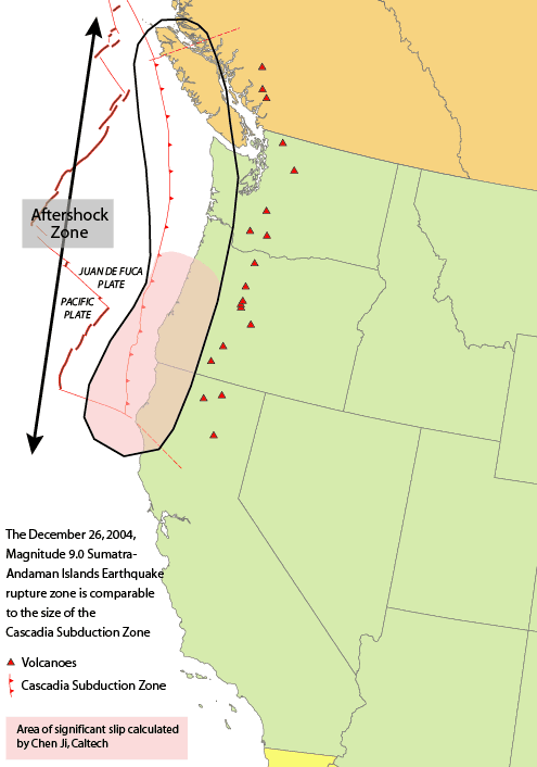
The most celebrated example of paleoseismological discovery is the Cascadia subduction zone, which extends approximately 1,100 kilometres from northern California to Vancouver Island. Prior to the late 1980s, the absence of large historical earthquakes led many seismologists to classify Cascadia as aseismic or weakly coupled. Brian Atwater's 1987 discovery of buried tidal marshes along the Washington coast — marshes that had been abruptly submerged by coseismic subsidence and covered by tsunami sand sheets — overturned this view and demonstrated that Cascadia produces great megathrust earthquakes.5 Subsequent radiocarbon dating of the most recent buried marsh horizon, combined with the discovery of an orphan tsunami recorded in Japanese historical documents on 26 January 1700, pinpointed the last full-margin Cascadia rupture to approximately magnitude 9.0 on that date.4
Offshore, turbidite paleoseismology has extended the Cascadia earthquake record through the entire Holocene. Chris Goldfinger and colleagues identified 19 full-margin turbidite events in cores from Cascadia submarine channels over the last 10,000 years, with an average recurrence interval of approximately 500 years for full-margin ruptures, plus additional smaller events on individual segments.6 Similar turbidite-based approaches have been applied to the subduction zones of Sumatra, Japan, Chile, and New Zealand, revealing that supercycle behaviour — in which several centuries of partial ruptures are followed by an exceptionally large event that ruptures the entire margin — may be a common feature of megathrust earthquake sequences.6, 14
Modern monitoring and hazard implications
The advent of space geodesy, particularly the Global Positioning System (GPS), has transformed the study of subduction zone strain accumulation. Dense GPS networks along subduction margins such as Cascadia, Japan, and Chile now measure interseismic crustal deformation in near-real time, revealing the spatial pattern of locking on the megathrust interface and enabling estimates of which segments are accumulating the most elastic strain.17, 13 Along the Cascadia margin, GPS measurements show that the coast of Washington and Oregon is being compressed and dragged eastward at 10–20 millimetres per year, consistent with a fully locked megathrust accumulating strain that will eventually be released in future great earthquakes.17
The recognition that subduction zones previously considered quiet are capable of magnitude 9 events has profoundly altered seismic and tsunami hazard assessment worldwide. Before 2004, neither the Sumatra-Andaman nor the Tohoku subduction zones were widely expected to produce magnitude 9 earthquakes, and the resulting casualties reflected that underestimation.1, 3 The lessons of these events — that all subduction zones with wide seismogenic zones must be considered capable of the largest earthquakes, that shallow near-trench slip can amplify tsunamis beyond historical precedent, and that paleoseismological evidence must be incorporated into hazard models — now form the foundation of modern seismic hazard analysis for subduction margins around the Pacific and Indian Oceans.11, 14, 16
References
A fault scarp on the sea floor: evidence for a tsunami in Cascadia about 300 years ago
Turbidite event history — methods and implications for Holocene paleoseismicity of the Cascadia subduction zone
Interseismic strain accumulation and the earthquake potential on the southern San Andreas fault system