Overview
- The global mid-ocean ridge system is a continuous submarine mountain chain stretching approximately 65,000 kilometres through every major ocean basin, making it the longest and most volcanically active geological feature on Earth and the site where all oceanic crust is created.
- Ridge morphology and magmatic character vary systematically with spreading rate: fast-spreading ridges such as the East Pacific Rise have broad, smooth profiles fed by persistent axial magma lenses, while slow-spreading ridges such as the Mid-Atlantic Ridge develop deep rift valleys, episodic volcanism, and exposures of mantle rock on the seafloor.
- Mid-ocean ridges host black smoker hydrothermal vents supporting chemosynthetic ecosystems independent of sunlight, generate the symmetric magnetic anomaly stripes that confirmed plate tectonics, and contribute ridge push as one of the forces driving plate motion.
Mid-ocean ridges are the continuous chain of submarine volcanic mountains where new oceanic lithosphere is created as tectonic plates diverge. Stretching approximately 65,000 kilometres through the Atlantic, Pacific, Indian, Arctic, and Southern oceans, the global ridge system is the longest mountain range and the single most volcanically active feature on Earth, generating roughly 3.4 square kilometres of new crust each year.3 The ridges mark the divergent boundaries of plate tectonics, and the processes operating along them — mantle upwelling, partial melting, magma emplacement, and seafloor spreading — are responsible for producing the entire oceanic crust that covers approximately 60 percent of the planet's solid surface.1, 3
The global ridge system
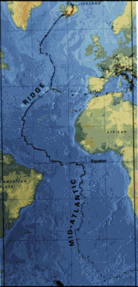
The mid-ocean ridge system was first recognised as a continuous global feature in the 1950s through the bathymetric mapping work of Marie Tharp and Bruce Heezen at the Lamont Geological Observatory.15 Working from echo-sounding profiles collected by research vessels, Tharp identified a continuous rift valley running along the crest of the Mid-Atlantic Ridge and demonstrated that this feature extended into the Indian and Pacific oceans as part of a single, interconnected system. Her physiographic maps, published in collaboration with Heezen beginning in 1957, provided the first visual evidence of a global submarine mountain chain and were instrumental in reviving scientific interest in continental drift and the mobilist view of Earth's lithosphere.15
The major segments of the system include the Mid-Atlantic Ridge, which runs from the Arctic Ocean southward through the centre of the Atlantic for over 16,000 kilometres; the East Pacific Rise (EPR), which extends from the Gulf of California southward into the South Pacific; the Southeast Indian Ridge and Southwest Indian Ridge, which diverge from a triple junction south of Africa; the Central Indian Ridge in the western Indian Ocean; and the Gakkel Ridge beneath the Arctic Ocean.3, 5 Although the ridges are conventionally described as "mid-ocean," their position within an ocean basin is not fixed at the centre. The East Pacific Rise, for example, lies far to the east of the Pacific basin's midpoint, and the ridge system's geometry reflects the cumulative history of plate motions, continental breakup, and the opening and closing of ocean basins over hundreds of millions of years.3
Mantle upwelling and partial melting
The fundamental driving process beneath a mid-ocean ridge is the passive upwelling of asthenospheric mantle in response to the divergence of the overlying plates. As the two flanking plates move apart, hot mantle rock rises to fill the space created, ascending along a broad zone that narrows toward the ridge axis.17 This upwelling is described as "passive" because it is driven primarily by plate separation rather than by a deep thermal anomaly — distinguishing ridge volcanism from the "active" upwelling associated with mantle plumes, though plumes can interact with ridges where the two coincide, as at Iceland.
As the mantle peridotite ascends, the decrease in confining pressure lowers its solidus temperature while the rock remains nearly at its original high temperature, initiating decompression melting.17 Melting typically begins at depths of 60 to 80 kilometres beneath the ridge axis, and by the time the mantle material has risen to within 10 to 20 kilometres of the surface, roughly 10 to 20 percent of the original peridotite has melted to produce basaltic magma.17 This melt is less dense than the residual mantle and percolates upward through pore spaces and fractures, collecting in a magma storage zone beneath the ridge axis. The composition of the resulting basalt — mid-ocean ridge basalt, or MORB — is remarkably uniform worldwide, reflecting the broadly homogeneous composition of the depleted upper mantle source and the consistent pressure-temperature conditions under which partial melting occurs.6, 17
Magma chamber structure
The sub-axial magma storage system has been imaged in detail by multichannel seismic reflection surveys, which reveal that the popular conception of a large, fully molten magma chamber is inaccurate. At fast-spreading ridges such as the East Pacific Rise, the melt-rich zone is a thin lens typically only tens of metres thick and one to two kilometres wide, centred at a depth of roughly 1.0 to 2.5 kilometres below the seafloor.4 This axial magma lens sits atop a much broader region of crystal-rich mush — a mixture of solidified crystite and interstitial melt — that extends several kilometres deeper and several kilometres wider than the lens itself. It is from this combined system of lens and mush zone that magma is extracted to feed dike intrusions and surface eruptions at the ridge axis.4, 6
At slow-spreading ridges like the Mid-Atlantic Ridge, a persistent axial magma lens is often absent entirely. Magma supply is more episodic, arriving in discrete pulses separated by long intervals of tectonic extension, during which the lithosphere stretches and thins by normal faulting rather than by magmatic injection.1, 4 The crustal accretion process at slow ridges is consequently more irregular, producing crust that varies significantly in thickness over short distances and that may include sections where mantle peridotite is exposed directly on the seafloor without any volcanic cover.19, 20
Crustal architecture: the ophiolite sequence
The layered internal structure of oceanic crust produced at mid-ocean ridges has been documented both by seismic refraction studies of the ocean floor and by direct geological observation of ophiolites — slabs of ancient oceanic lithosphere that have been tectonically emplaced onto continental margins. The canonical crustal sequence, codified at the 1972 Penrose Conference, comprises four principal units from top to bottom.14
The uppermost layer consists of pillow basalts, the characteristic product of submarine volcanic eruption. When basaltic lava erupts into cold seawater, the outer surface quenches almost instantly to form a glassy rind while the interior continues to flow, producing bulbous, pillow-shaped masses that stack upon one another in layers up to one to two kilometres thick.6, 14 Beneath the pillow basalts lies the sheeted dike complex, a dense array of vertical to subvertical tabular intrusions of basalt that represent the frozen conduits through which magma rose from the underlying chamber to feed surface eruptions. Each dike intruded into the centre of its predecessor, producing a distinctive pattern in which every dike is chilled on one margin against its neighbour — a geometry that can only form at a spreading axis where new space is continuously created.14
Below the sheeted dikes lies a layer of gabbro, the coarse-grained plutonic equivalent of basalt that crystallised slowly in the axial magma chamber. The gabbro section is typically three to five kilometres thick and transitions at its base into cumulate ultramafic rocks — dense, olivine-rich material that settled to the bottom of the magma chamber during crystallisation. Beneath the crustal section lies the Moho (Mohorovicic discontinuity) and the residual mantle peridotite, the depleted rock left behind after partial melting extracted the basaltic component.6 This complete sequence — sediment, pillow basalt, sheeted dikes, gabbro, and mantle peridotite — is preserved in large ophiolite complexes such as the Semail ophiolite of Oman and the Troodos ophiolite of Cyprus, providing accessible cross-sections through oceanic crust that would otherwise be buried beneath kilometres of seawater.14
Fast-spreading and slow-spreading ridges
The morphology, magmatic character, and faulting style of a ridge segment depend fundamentally on its spreading rate — the full velocity at which the two flanking plates diverge. Spreading rates range from less than 20 millimetres per year at ultraslow ridges to more than 150 millimetres per year at the fastest segments of the East Pacific Rise, and this single parameter controls a cascade of linked geological differences.5, 2
Fast-spreading ridges, exemplified by the East Pacific Rise at full rates of 80 to 150 millimetres per year, have a topographic profile consisting of a broad, gentle dome rising only 200 to 400 metres above the surrounding abyssal plains. The ridge axis is marked by a narrow axial summit trough, typically less than 100 metres wide and a few tens of metres deep, rather than a prominent rift valley.1 The robust and nearly continuous magma supply at fast ridges sustains a persistent axial magma lens, produces relatively uniform layered crust six to seven kilometres thick, and generates smooth volcanic terrain dominated by sheet and lobate lava flows.4
Slow-spreading ridges, typified by the Mid-Atlantic Ridge at full rates of 20 to 50 millimetres per year, display a strikingly different character. The ridge axis is defined by a prominent rift valley one to two kilometres deep and 15 to 30 kilometres wide, bounded by steep normal faults.1, 2 Magma supply is intermittent, and substantial crustal extension is accommodated by faulting rather than by volcanic injection. The resulting crust is thinner, more heterogeneous, and in some segments entirely lacking a volcanic layer, with mantle peridotite exposed on the seafloor through the development of oceanic core complexes — dome-shaped structures where deep crustal and upper-mantle rock has been exhumed along long-lived detachment faults.19, 20
Ultraslow-spreading ridges, recognised as a distinct class in 2003, spread at full rates below approximately 12 millimetres per year. The Gakkel Ridge beneath the Arctic Ocean and the western portion of the Southwest Indian Ridge are the principal examples.19 At these ridges, magma supply is so sparse that long amagmatic segments — stretches of tens of kilometres where no volcanic crust forms at all — alternate with widely spaced volcanic centres. The crust is thin or absent, and the seafloor is composed largely of serpentinised mantle peridotite.19
Transform faults and ridge segmentation
Mid-ocean ridges are not continuous, uninterrupted features. They are systematically offset by transform faults — a class of plate boundary first recognised and named by J. Tuzo Wilson in 1965.8 Transform faults connect offset segments of the ridge axis, with the two plates sliding laterally past each other along the fault. Unlike conventional strike-slip faults, the sense of motion along a ridge-to-ridge transform is opposite to the apparent offset of the ridge segments: the plates move apart at the ridges and slide past each other along the transform, producing seismicity only on the active segment between the two ridge tips.8, 18
The fracture zone that extends beyond the active transform into the plates on either side is a scar in the lithosphere that records the history of plate motion but is no longer seismically active. These fracture zones can be traced for thousands of kilometres across the ocean floor and produce prominent topographic steps where crust of different ages and therefore different thermal subsidence histories lies in contact.13
Ridge segmentation occurs at multiple scales. First-order segments are hundreds of kilometres long and bounded by major transform faults with offsets of tens to hundreds of kilometres. Second-, third-, and fourth-order segments are progressively shorter and offset by smaller non-transform discontinuities — overlapping spreading centres, propagating rifts, and deviations in the axial volcanic ridge — that reflect variations in magma supply along the ridge axis.2 This hierarchical segmentation pattern is best documented at the East Pacific Rise, where detailed bathymetric mapping has revealed that each segment is supplied by a discrete pulse of magma from the underlying mantle, with segment boundaries corresponding to zones of reduced magmatic activity.2
Magnetic anomaly stripes
One of the most consequential properties of mid-ocean ridges is their role in generating the symmetric magnetic anomaly stripes that provided decisive evidence for seafloor spreading and, by extension, for plate tectonics. As basaltic magma erupts at the ridge axis and cools below the Curie temperature of its iron-bearing minerals — principally magnetite — the crystals acquire a permanent magnetisation aligned with Earth's ambient magnetic field.7 Because the geomagnetic field periodically reverses its polarity, each increment of newly formed crust records the field orientation prevailing at the time of its creation.
As seafloor spreading carries this magnetised crust away from the ridge in both directions simultaneously, the result is a sequence of alternating normally and reversely magnetised bands extending outward from the axis, producing a mirror-image pattern on the two flanks.7 This pattern, predicted by Vine and Matthews in 1963, can be matched to the independently established geomagnetic polarity timescale, allowing the age and spreading rate of any segment of ocean floor to be determined from its magnetic anomaly profile. The ocean floor thus functions as a magnetic tape recorder, preserving a continuous chronological archive of its own formation.7, 3 Global compilations of magnetic anomaly data and deep-sea drilling results have been synthesised into digital age maps of the entire ocean floor, confirming that the oldest surviving oceanic crust — approximately 200 million years old, in the western Pacific — is young relative to the 4.5-billion-year age of the Earth, because all older crust has been recycled through subduction.3
Hydrothermal vents and chemosynthetic life
The magmatic heat beneath mid-ocean ridges drives vigorous hydrothermal circulation through the permeable upper crust. Cold seawater percolates downward through fractures in the basalt, is progressively heated as it approaches the axial magma chamber, reacts chemically with the surrounding rock to become enriched in dissolved metals and reduced gases, and then rises buoyantly back to the seafloor along focussed upflow zones.16 The first direct observation of this process came in 1977, when the submersible Alvin discovered warm springs and associated biological communities on the Galápagos Rift.9
The most dramatic expression of ridge hydrothermal activity is the black smoker — a chimney-like structure that vents superheated fluid at temperatures up to 400 degrees Celsius. The "smoke" consists of fine-grained metal sulfide particles, predominantly iron, copper, and zinc sulfides, that precipitate instantly when the hot, chemically reduced vent fluid meets the cold, oxygenated ambient seawater.10 Over time, these precipitates accumulate to form polymetallic sulfide mounds that are the modern analogues of the volcanogenic massive sulfide ore deposits mined on land. White smokers, by contrast, emit cooler fluids (150 to 300 degrees Celsius) enriched in silica and barium, producing lighter-coloured precipitates.10
The ecosystems surrounding hydrothermal vents are among the most remarkable on Earth, sustained entirely by chemosynthesis rather than photosynthesis. Chemoautotrophic bacteria and archaea at the base of the food web oxidise hydrogen sulfide and other reduced compounds in the vent fluids to fix carbon, supporting dense communities of specialised organisms including giant tube worms (Riftia pachyptila), bathymodiolin mussels, and vent shrimp.9, 21 The total hydrothermal flux at mid-ocean ridges is sufficient to cycle the entire volume of the world's oceans through the ridge system every 10 to 20 million years, exerting a significant influence on the chemistry of seawater, particularly the concentrations of magnesium, calcium, lithium, and manganese.16
Ridge push and plate driving forces
Mid-ocean ridges contribute to the forces that drive tectonic plate motion through a mechanism known as ridge push. The newly formed lithosphere at the ridge axis is hot, thin, and elevated; as it moves away from the ridge and cools, it thickens and subsides, creating a gravitational potential energy gradient that pushes the plate away from the ridge crest.11, 13 The systematic deepening of the ocean floor with age follows a well-characterised relationship in which seafloor depth increases approximately as the square root of crustal age, a pattern explained by the thermal contraction of the cooling lithospheric plate.13
Ridge push is one of two principal forces acting on tectonic plates, the other being slab pull — the gravitational force exerted by cold, dense subducting lithosphere sinking into the mantle at subduction zones.12 Quantitative analyses of plate velocities and the forces acting on them have consistently found that slab pull is the dominant driving force, with plates attached to long subduction zones (such as the Pacific and Nazca plates) moving substantially faster than plates without subducting margins.11, 12 Ridge push, while secondary in magnitude, is a contributing factor that acts on all plates bounded by mid-ocean ridges and is transmitted through the rigid lithosphere as a body force rather than acting only at the plate edge.
Axial valley morphology and depth
The topographic expression of a mid-ocean ridge axis — whether it takes the form of a gentle dome or a deep rift valley — is controlled by the balance between magmatic construction and tectonic extension, which in turn depends on spreading rate and magma supply.1 At fast-spreading ridges, the high rate of magma delivery maintains a hot, weak axial zone that cannot sustain the stresses needed to form large normal faults, resulting in a smooth topographic high. At slow-spreading ridges, the reduced and intermittent magma supply produces a stronger, more brittle axial lithosphere that fractures under extensional stress, forming the bounding faults of the rift valley.1, 2
The crestal depth of a mid-ocean ridge varies systematically with spreading rate and proximity to mantle thermal anomalies. The shallowest portions of the ridge system occur where the ridge intersects a hotspot — Iceland, the Azores, and the Galápagos, for example — where the excess mantle temperature produces anomalously high volumes of melt, thickens the crust, and elevates the ridge above the normal depth-age curve.17 In the case of Iceland, the interaction between the Mid-Atlantic Ridge and the Iceland plume has produced so much excess volcanism that the ridge crest rises above sea level, providing the only location where a mid-ocean ridge can be observed on land.17 Away from hotspot influences, the typical axial depth of a mid-ocean ridge lies between 2,000 and 3,000 metres below sea level, deepening systematically with decreasing spreading rate as the reduced magma supply produces thinner crust and a cooler, denser axial lithosphere.1, 13
Marie Tharp and the mapping of the ridge system
The recognition of mid-ocean ridges as a coherent global system owes a singular debt to the work of Marie Tharp (1920–2006), a geologist and cartographer at the Lamont Geological Observatory of Columbia University. Beginning in the early 1950s, Tharp systematically plotted the depth soundings collected by Lamont research vessels into detailed physiographic diagrams of the North Atlantic ocean floor.15 In doing so, she identified a continuous V-shaped rift valley running along the crest of the Mid-Atlantic Ridge — a feature she immediately recognised as consistent with extensional tectonics and divergent plate motion. Her collaborator Bruce Heezen was initially dismissive of the interpretation, associating it with the then-discredited hypothesis of continental drift, but the accumulation of earthquake epicentre data along the rift axis ultimately vindicated her observation.15
Through the late 1950s and 1960s, Tharp and Heezen extended their mapping to every ocean basin, producing the landmark physiographic maps of the world's ocean floors that demonstrated the continuity of the mid-ocean ridge system as a single, globe-encircling feature. These maps, rendered in Tharp's meticulous pen-and-ink style, were widely reproduced and became the visual foundation upon which the plate tectonic revolution was built.15 Tharp's contribution was long underacknowledged in a field that largely excluded women from shipboard research — she was never permitted to go to sea during the years of her most important work — but is now recognised as one of the pivotal achievements in twentieth-century earth science.15
References
Ophiolites and oceanic crust: new insights from field studies and the Ocean Drilling Program
Oceanic core complexes: formation of the deep ocean crust at slow- and ultraslow-spreading ridges