Overview
- Pangaea was the most recent supercontinent, assembling during the late Carboniferous through early Permian (~335–270 Ma) as the collision of Gondwana and Laurussia closed the Rheic Ocean and raised the Variscan–Alleghanian mountain belts, ultimately uniting nearly all continental crust into a single landmass stretching from pole to pole, surrounded by the global ocean Panthalassa.
- The supercontinent profoundly altered Earth's climate and biosphere: its vast continental interior experienced extreme aridity and intense monsoonal circulation, its configuration restricted ocean currents and may have contributed to the end-Permian mass extinction, and its existence is evidenced by matching fossil distributions (Glossopteris, Mesosaurus, Lystrosaurus), continuous mountain belts, glacial tillites, and paleomagnetic data across now-separated continents.
- Pangaea began to fragment around 200 Ma, triggered in part by the Central Atlantic Magmatic Province, first splitting into Laurasia and Gondwana before further rifting opened the Atlantic and Indian Oceans and dispersed the continents into their modern configuration — a process that continues today.
Pangaea — from the Ancient Greek pan (“all”) and gaia (“land”) — was the most recent supercontinent in Earth’s history. Assembled during the late Paleozoic as the world’s major landmasses converged through a series of collisional orogenies, it united nearly all of Earth’s continental crust into a single, C-shaped mass that stretched from the high northern latitudes to the South Pole, surrounded by a global ocean called Panthalassa and partially enclosing a wedge-shaped seaway, the Tethys, to the east.3, 14 The existence of Pangaea was first proposed by Alfred Wegener in 1912 as part of his continental drift hypothesis, and although the idea was rejected for decades, it was ultimately vindicated by the plate tectonic revolution of the 1960s.1, 8 Pangaea’s assembly, persistence, and eventual fragmentation shaped global climate, ocean circulation, and the course of biological evolution for hundreds of millions of years, and the consequences of its breakup — the opening of the Atlantic and Indian Oceans, the dispersal of the continents to their modern positions — are still unfolding today.
Wegener and the hypothesis of a former supercontinent
The idea that the continents were once joined has roots that reach back centuries — Francis Bacon noted the complementary shapes of the Atlantic coastlines in 1620, and Antonio Snider-Pellegrini published a reconstruction of the joined continents in 1858 — but the first systematic scientific case was made by Alfred Wegener, a German meteorologist and Arctic explorer, who presented his continental drift hypothesis in a lecture to the Geological Association in Frankfurt on 6 January 1912 and published it in expanded form in his 1915 book Die Entstehung der Kontinente und Ozeane.1 Wegener coined the name Pangaea (sometimes spelled Pangea) for the primordial supercontinent from which, he argued, all modern continents had separated during the Mesozoic era.
Wegener assembled evidence from four independent domains. The geometric fit of the continents, particularly the Atlantic margins of South America and Africa, was striking even at the level of modern continental shelves, as Edward Bullard and colleagues demonstrated quantitatively in 1965 using computer-assisted fitting.2 The distribution of identical fossil organisms across continents now separated by thousands of kilometres of ocean — the Permian freshwater reptile Mesosaurus in both Brazil and South Africa, the Permian–Triassic seed fern Glossopteris across all southern continents, the Early Triassic therapsid Lystrosaurus on every Gondwanan landmass — could be explained only by former land connections or by the continents having once been joined.1, 4 Matching geological structures, including the continuity of the Caledonian–Appalachian mountain belt from Scandinavia through Scotland to eastern North America, provided further support.1, 16 And paleoclimatic evidence — Late Paleozoic glacial tillites and striated pavements on continents that now lie in the tropics, coal deposits in regions now at high latitudes — made sense only if the continents had occupied radically different positions in the past.1, 15
Despite this evidence, the hypothesis was rejected by most geophysicists, particularly in Britain and the United States, because Wegener could not identify a plausible mechanism for moving continents through rigid oceanic crust. Harold Jeffreys demonstrated that the centrifugal and tidal forces Wegener invoked were far too weak.8 It was not until the discovery of seafloor spreading, paleomagnetism, and the synthesis of plate tectonics in the 1960s that Wegener’s reconstruction of Pangaea was confirmed as essentially correct, even if his mechanism had been wrong.
Assembly of Pangaea
The assembly of Pangaea was not a single event but a protracted process spanning roughly 150 million years, from the Late Devonian through the early Permian (~380–270 Ma), involving the convergence and collision of several major continental blocks.3, 5
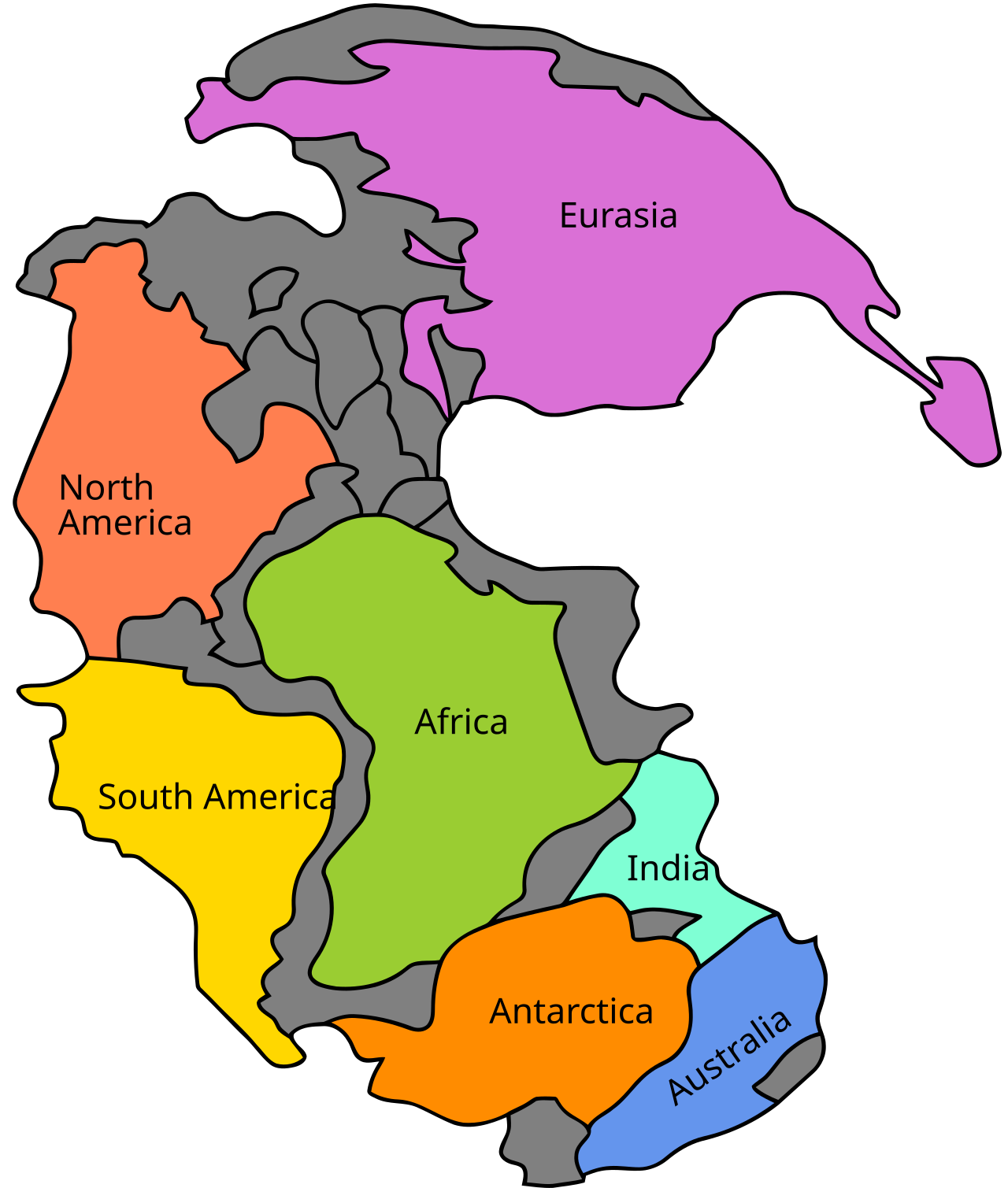
The principal components were two large landmasses. Gondwana, the southern supercontinent, comprised what are now South America, Africa, Antarctica, Australia, India, and Madagascar, along with smaller fragments such as Arabia. Gondwana had existed as a coherent entity since the late Neoproterozoic (~550 Ma) and occupied predominantly southern latitudes throughout the Paleozoic.3, 15 To the north lay Laurussia (also called Euramerica or the Old Red Sandstone Continent), which had formed in the early Devonian (~410 Ma) through the collision of Laurentia (ancestral North America plus Greenland), Baltica (ancestral Scandinavia and eastern Europe), and the microcontinent Avalonia, closing the Iapetus Ocean and producing the Caledonian orogeny.16
The collision of Gondwana with Laurussia during the Carboniferous and early Permian closed the Rheic Ocean and produced the Variscan (Hercynian) and Alleghanian orogenies — a chain of mountain-building events whose eroded remnants are preserved today in the Appalachian Mountains of eastern North America, the Ouachita Mountains of the south-central United States, the Mauritanides of West Africa, and the Hercynian massifs of western and central Europe.3, 16 Additional terranes accreted to the growing supercontinent along its margins. The collision of the Kazakhstania and Siberia blocks with Laurussia closed the Ural Ocean and formed the Ural Mountains, incorporating these Asian cratons into the supercontinent by the late Permian.3 Smaller blocks, including portions of what would become China and Southeast Asia, docked against the eastern margin of Pangaea during the late Paleozoic and early Mesozoic, though some, such as the South China and North China cratons, remained partially separated by remnants of the Paleo-Tethys Ocean.3, 14
By approximately 300–270 Ma, in the late Carboniferous to early Permian, the assembly was essentially complete. Pangaea stretched from the northern high latitudes, where Siberia lay, to the South Pole, which was occupied by what is now Antarctica and southern Gondwana. It was the last time that nearly all of Earth’s continental crust was united in a single landmass.3, 5
Panthalassa and the Tethys Sea
The concentration of continental crust into a single supercontinent necessarily implied a complementary concentration of oceanic crust. The vast ocean that surrounded Pangaea on all sides is called Panthalassa (Greek for “all sea”), and it occupied approximately 70 percent of Earth’s surface — a proportion far greater than any single ocean basin today.14 Panthalassa was the ancestor of the modern Pacific Ocean, though continuous subduction around its margins means that almost none of the Panthalassan oceanic crust survives; the oldest oceanic crust on Earth today dates only to the middle Jurassic (~200 Ma).3
The Tethys Sea was a large, roughly triangular embayment that opened eastward into Panthalassa between the northern (Laurasian) and southern (Gondwanan) portions of Pangaea.14 Its history is complex: the Paleo-Tethys Ocean, which had separated several microcontinents from the northern margin of Gondwana during the Paleozoic, was progressively consumed as these blocks (Cimmeria) migrated northward and accreted to Laurasia during the Triassic, while a new seaway — the Neo-Tethys — opened behind them along the northern Gondwanan margin.3, 14 The Tethys was a critical pathway for equatorial ocean circulation and marine biogeographic exchange during the Mesozoic. Its eventual closure, through the northward migration and collision of Africa, Arabia, and India with Eurasia, produced the Alpine–Himalayan mountain chain and left the Mediterranean Sea as its last remnant.14
Paleoclimatic consequences
The existence of a single supercontinent stretching across most latitudes had profound consequences for global climate. General circulation model simulations by Kutzbach and Gallimore demonstrated that Pangaea’s vast continental interior would have experienced extreme continentality — hot summers, cold winters, and pervasive aridity far from the moderating influence of the ocean.6 The large land area at low latitudes would have driven intense heating of the continental surface, producing a powerful monsoonal circulation: seasonal reversals of wind direction that brought heavy rainfall to coastal margins during summer and dry conditions during winter.6, 7
Geological evidence strongly supports these model predictions. Upper Triassic sedimentary deposits across what was then the interior of Pangaea — the Chinle Formation of the western United States, the Newark Supergroup basins of eastern North America, and correlative strata in Europe and North Africa — record cyclical alternations between humid and arid conditions consistent with strong monsoonal forcing.17 Extensive evaporite deposits (salt and gypsum) of Permian and Triassic age in central Pangaea testify to extreme aridity in the continental interior, while coal-bearing sequences along the continental margins indicate wetter, more equable conditions near the coasts.6, 7
The late Paleozoic, when Pangaea was at or near maximum assembly, also witnessed the Late Paleozoic Ice Age — a series of glaciations that affected Gondwana from the late Carboniferous through the early Permian (~360–260 Ma).15, 20 Glacial tillites, striated bedrock surfaces, and dropstone-bearing marine sediments are found in South America, Africa, India, Australia, and Antarctica — regions that were clustered around the South Pole during this interval. The position of Gondwana over the pole, facilitated by the Pangaean configuration, was a necessary condition for the growth of continental ice sheets, though the drawdown of atmospheric CO2 by the burial of organic carbon in the extensive Carboniferous coal swamps also played a critical role.15
Paleobiogeographic evidence
Some of the most compelling evidence for the existence of Pangaea comes from the distribution of fossil organisms across continents that are now separated by wide oceans. These biogeographic patterns were central to Wegener’s original argument and remain foundational to modern reconstructions.1, 4
The Glossopteris flora — a distinctive assemblage of seed ferns characterized by tongue-shaped leaves and associated reproductive structures — dominated the vegetation of the southern continents during the Permian and early Triassic.1, 4 Glossopteris fossils are found in South America, Africa, India, Australia, and Antarctica, a distribution that Alexander du Toit used to define the Gondwanan realm in his 1937 treatise Our Wandering Continents.4 The plants were adapted to cool temperate conditions and grew in soils overlying glacial deposits, indicating that the southern continents shared a common climate regime and were connected by continuous land — exactly as a Pangaean reconstruction predicts.
Among vertebrate fossils, three genera are particularly diagnostic. Mesosaurus, a small freshwater reptile from the early Permian, is found exclusively in the Irati Formation of Brazil and the Whitehill Formation of South Africa — formations that align precisely when South America and Africa are reassembled in the Pangaean configuration.1 Lystrosaurus, a pig-sized dicynodont therapsid that survived the end-Permian extinction, is known from the Lower Triassic of South Africa, India, China, Russia, and Antarctica, a distribution spanning multiple modern continents but forming a coherent range on reconstructed Pangaea.18 Cynognathus, a large carnivorous cynodont from the Early to Middle Triassic, occurs in South America and Africa, further confirming the connection between these landmasses.4 The fact that these organisms — including freshwater forms incapable of crossing salt water — are found on multiple continents constitutes powerful evidence for physical land continuity, as biogeographic dispersal across oceanic barriers cannot explain their distributions.1, 4
Geological and paleomagnetic evidence
Beyond fossils and climate, the geological record preserves structural and geophysical evidence for Pangaea that is equally compelling. Mountain belts formed by the collisions that assembled the supercontinent can be traced across now-separated continents. The Appalachian–Caledonian–Variscan orogenic system forms a continuous belt when North America, Europe, and Africa are reassembled, recording the successive closures of the Iapetus and Rheic Oceans.16 The Cape Fold Belt of South Africa aligns with the Sierra de la Ventana of Argentina and the Ellsworth Mountains of Antarctica, preserving the suture of the Gondwanide orogen along the southern margin of Pangaea.3
Stratigraphic correlations provide additional support. Identical sequences of Late Paleozoic sedimentary rocks — glacial tillites overlain by coal measures overlain by red beds — can be matched across the southern continents in a pattern that makes sense only if those continents were contiguous.15 Precambrian basement rocks of the same age and composition occur on both sides of the Atlantic: the West African Craton and the Amazonian Craton, the Congo Craton and the Sao Francisco Craton, the Kalahari Craton and the Rio de la Plata Craton all share geological histories that diverge only after the Mesozoic breakup of Gondwana.3
Paleomagnetic data provide the most quantitative constraints on Pangaea’s configuration. When the apparent polar wander paths — the trajectories of the magnetic pole as recorded by the remnant magnetization in rocks of successive ages from a given continent — are calculated for different continents in their present positions, they diverge. When the continents are reassembled in the Pangaean configuration, the paths converge into a single, coherent trajectory, confirming that the continents moved together as a unit during the late Paleozoic and early Mesozoic.9, 10, 19 Paleomagnetic inclination data also constrain the latitudinal position of each continent through time, providing an independent check on paleogeographic reconstructions derived from geological and fossil evidence.19
Pangaea and the end-Permian extinction
The configuration of Pangaea may have contributed to the greatest biological catastrophe in the history of life: the end-Permian mass extinction at approximately 252 Ma, which eliminated an estimated 81 percent of marine species and 70 percent of terrestrial vertebrate species.12
The primary trigger of the extinction is widely attributed to the eruption of the Siberian Traps, a large igneous province that produced an estimated 2–3 million cubic kilometres of basaltic lava and released enormous quantities of CO2, SO2, and halogenated gases into the atmosphere, driving rapid global warming, ocean acidification, and anoxia.13 However, the Pangaean configuration amplified the lethality of these perturbations through several mechanisms. The supercontinent’s restriction of equatorial ocean circulation reduced the efficiency of heat transport from low to high latitudes, steepening the equator-to-pole temperature gradient and making the climate system more vulnerable to forcing.6 The single, enormous landmass reduced the total length of coastline relative to continental area, compressing the marine shelf habitat on which the majority of marine species depended and increasing their vulnerability to sea-level and temperature fluctuations.12 And the stagnation of deep-ocean circulation — driven in part by the geometry of a single-ocean basin with limited thermohaline overturning — may have preconditioned the oceans for the development of widespread anoxia even before the Siberian eruptions began.12, 13
The aftermath of the end-Permian crisis unfolded on a still-united Pangaea. The cosmopolitan distribution of Lystrosaurus across the Lower Triassic of multiple continents reflects both the survival of a generalist taxon and the absence of oceanic barriers to dispersal on the supercontinent.18 The Triassic recovery of terrestrial ecosystems, including the rise of the archosaurs that would give rise to dinosaurs, occurred within the Pangaean framework before the supercontinent began to fragment.
Breakup of Pangaea
The fragmentation of Pangaea began in the late Triassic to early Jurassic, approximately 200 million years ago, and proceeded in stages over the following 150 million years.3, 14
The earliest phase of rifting was heralded by the emplacement of the Central Atlantic Magmatic Province (CAMP) at approximately 201 Ma, one of the largest large igneous provinces in Earth’s history.11 CAMP basalts and associated intrusions are found in eastern North America, West Africa, northeastern South America, and southwestern Europe — the very regions that would separate as the Central Atlantic opened. The province’s eruption coincided with the end-Triassic mass extinction, suggesting a causal link between Pangaean rifting, flood volcanism, and biotic crisis analogous to the Siberian Traps–end-Permian connection.11 Rifting along the Central Atlantic initiated the separation of North America from Africa, and by the Middle Jurassic (~170 Ma) true oceanic crust was being produced along the nascent Mid-Atlantic Ridge.21
The initial split divided Pangaea into two major fragments along approximately the line of the former Tethys: Laurasia in the north, comprising North America, Europe, and Asia; and Gondwana in the south, comprising South America, Africa, Antarctica, Australia, India, and Madagascar.3, 14 Du Toit had proposed this two-fold division in 1937, and modern plate reconstructions confirm it as a first-order feature of the breakup.4
Gondwana itself then fragmented in a series of successive rifting events. East Gondwana (India, Australia, Antarctica, Madagascar) separated from West Gondwana (Africa, South America) during the Middle Jurassic to Early Cretaceous (~170–130 Ma), opening the western Indian Ocean.3 South America began to separate from Africa during the Early Cretaceous (~130 Ma), initially forming a narrow seaway in the south that widened progressively northward; the South Atlantic Ocean was fully open by approximately 100 Ma.3, 21 India detached from Madagascar around 88 Ma and began its rapid northward migration across the shrinking Tethys Ocean, eventually colliding with Eurasia beginning around 50 Ma to raise the Himalayas.3 Australia separated from Antarctica during the Eocene (~45 Ma), opening the Southern Ocean and, once the Drake Passage between South America and Antarctica opened around 34–30 Ma, enabling the establishment of the Antarctic Circumpolar Current — a development with profound consequences for global climate and the onset of Antarctic glaciation.3, 14
Within Laurasia, the separation of North America from Eurasia proceeded more gradually. Rifting in the Labrador Sea and between Greenland and northwestern Europe during the Late Cretaceous and Paleogene opened the North Atlantic in stages, a process punctuated by the eruption of the North Atlantic Igneous Province around 55 Ma.3 The Arctic Ocean basin is among the youngest of the world’s ocean basins, having formed through the spreading of the Gakkel Ridge beginning in the Eocene.
Modern plate reconstruction methods
The reconstruction of Pangaea and the tracking of its subsequent fragmentation rely on a convergence of independent methods, each contributing different constraints. Paleomagnetic data provide latitudinal positions and orientations of continents through time by measuring the direction and inclination of remnant magnetization in dated rock samples, though they cannot constrain longitude directly.10, 19 Marine magnetic anomalies — the symmetric stripes of normal and reversed polarity on the ocean floor produced by seafloor spreading — allow precise reconstruction of the relative motions of plates that share an intervening ocean basin, but only for the Jurassic and younger, because older oceanic crust has been subducted.3
For the Paleozoic assembly of Pangaea, where no oceanic crust survives, reconstructions depend on matching geological features across continent boundaries: the alignment of orogenic belts, the correlation of sedimentary facies, the comparison of detrital zircon age spectra in sandstones on opposite sides of a reconstructed suture, and the tracing of large igneous province remnants across now-separated continents.3, 16 Faunal and floral biogeography provides qualitative constraints: the degree of similarity between fossil assemblages on different continents reflects their proximity or connection, while the appearance of biogeographic barriers (disjunct distributions, endemic faunas) signals the opening of seaways.4
Computer-based plate reconstruction software, most notably GPlates, now allows researchers to integrate all of these datasets into self-consistent, time-resolved paleogeographic models that can be animated as continuous plate motions from the Precambrian to the present.14 The PALEOMAP Project, developed by Christopher Scotese, has produced widely used reconstructions that track the positions of the continents in 10–20 million year intervals throughout the Phanerozoic, and these maps have become standard references in textbooks, museum exhibits, and scientific publications.14 While uncertainties remain — particularly for the Paleozoic, where paleomagnetic data are sparse and the matching of geological features across eroded and deformed mountain belts is inherently interpretive — the broad outlines of Pangaea’s configuration and breakup history are now established beyond reasonable doubt by the convergence of independent lines of evidence.
The legacy of Pangaea in the modern world
The consequences of Pangaea’s existence and fragmentation are written into the modern world at every scale. The shapes of the continents, the positions of the ocean basins, and the geometry of the global mid-ocean ridge system are all direct products of the breakup.3 The Atlantic Ocean continues to widen at rates of 1–3 centimetres per year, while the Pacific — the diminished remnant of Panthalassa — continues to shrink as subduction consumes its margins.5 The Himalayan orogen, still rising as India drives into Eurasia, is a direct consequence of the dispersal of Gondwana. The East African Rift, where the African plate is beginning to split, may represent the earliest stage of a future continental breakup — another turn in the supercontinent cycle.5
The biogeographic legacy of Pangaea is equally profound. The distinctive faunas and floras of the southern continents — marsupials in Australia, lemurs in Madagascar, New World monkeys in South America — are products of the isolation that followed Gondwanan fragmentation, their evolutionary radiations shaped by the timing and sequence of continental separations.4 The faunal exchange that occurred when previously isolated continents reconnected — most dramatically the Great American Biotic Interchange after the formation of the Isthmus of Panama around 3 Ma — provides a modern echo of the biogeographic connectivity that Pangaea once provided across the entire terrestrial biosphere.
The study of Pangaea also illustrates a broader principle in Earth science: that the present configuration of the continents is a snapshot of a dynamic system, not a fixed arrangement. The supercontinent cycle predicts that the dispersal phase following Pangaea’s breakup will eventually reverse, as ocean basins close and continents converge once more. Several models for a future supercontinent have been proposed — Amasia, Pangaea Proxima, Aurica — each differing in which oceans close first and where the continents ultimately aggregate.5 What is certain is that the cycle will continue. The Earth’s mantle convects, its plates move, and the continents will converge again — as they have at least four times before — though no human will be alive to see it.