Overview
- An unconformity is a buried erosion surface or depositional hiatus in the rock record, representing a gap in time — sometimes spanning hundreds of millions of years — during which rock was either never deposited or was deposited and subsequently eroded away before the next sedimentary cycle began.
- There are three principal types: angular unconformities, where tilted or folded strata are truncated by overlying horizontal beds; disconformities, where parallel strata are separated by an erosion surface; and nonconformities, where sedimentary rocks overlie crystalline igneous or metamorphic basement.
- The Great Unconformity at the base of the Cambrian in the Grand Canyon represents roughly 1.2 billion years of missing record, and its near-global extent is now hypothesized to reflect massive glacially driven erosion during the Cryogenian Snowball Earth events, making it one of the most consequential geological puzzles of the modern era.
An unconformity is a contact surface within a sequence of sedimentary rocks that represents a significant gap in the geological record — an interval of time during which deposition either ceased entirely or was interrupted by erosion that removed previously accumulated material.4 Because the stratigraphic record is preserved only where sediment accumulates and is subsequently buried, the absence of strata is itself a form of geological information: it encodes episodes of crustal uplift, sea-level fall, and prolonged erosion that can span millions or even hundreds of millions of years.8 The physical surface marking such a gap is called the unconformity surface, and the strata above and below it are said to be unconformably related. The study of these surfaces, their geometry, their age, and their spatial extent, is central to stratigraphy and to the reconstruction of Earth’s tectonic and climatic history.
Unconformities are not merely curiosities of the rock record — they are among its most informative features. A buried erosion surface encodes the history of events that are entirely missing from local sections: entire mountain ranges may have risen and been ground to plains; ocean basins may have opened and partially closed; glaciers may have scoured continents to their crystalline roots. The surfaces that bound the missing time are thus windows into vanished worlds, the only surviving testimony to geological episodes that left no other local deposit. Interpreting unconformities correctly is therefore essential to reading Earth history with any accuracy, and understanding their global distribution has led to some of the most consequential discoveries in the history of geology — including James Hutton’s recognition in 1788 that the Earth must be immensely ancient, and the modern hypothesis that Snowball Earth glaciations sculpted the planet’s continental surfaces on an almost unimaginable scale.1, 6
Hutton’s discovery and the birth of deep time
The modern understanding of unconformities began on a June afternoon in 1788 when the Scottish geologist James Hutton, accompanied by the mathematician John Playfair and the geologist Sir James Hall, sailed into Siccar Point on the Berwickshire coast of Scotland.1 What Hutton saw there produced one of the most celebrated moments in the history of science. At the base of the sea cliff, near-vertical beds of grey Silurian greywacke — ancient deep-sea sediments compressed and tilted by long-vanished tectonic forces — were truncated by a nearly horizontal surface, above which lay gently dipping red sandstone beds of Devonian age.1, 10 The two rock packages were divided not merely by a physical surface but by an enormous gulf of time: the Silurian strata had been deposited on an ancient seafloor, lithified, tilted to near-vertical by mountain-building forces, then uplifted, eroded flat by millions of years of exposure, and finally submerged again so that Devonian sediments could accumulate on the planed surface. The entire cycle of deposition, deformation, erosion, and renewed deposition was written in the geometry of two rock bodies separated by a single line.
Playfair recorded his reaction with extraordinary vividness: “the mind seemed to grow giddy by looking so far into the abyss of time.”10 That giddiness was philosophically justified. Before Hutton, most natural philosophers in Europe assumed the Earth to be thousands, at most tens of thousands, of years old. Hutton’s recognition that the unconformity at Siccar Point required not two but at minimum three complete sedimentary and tectonic cycles — each requiring vast stretches of time — was the empirical foundation of what would become the concept of deep time.2, 3 His 1788 memoir to the Royal Society of Edinburgh, “Theory of the Earth,” presented unconformities as evidence that the Earth operated through slow, cyclical processes across durations that dwarfed human imagination. The contact at Siccar Point remains one of the most visited geological sites in the world, a pilgrimage destination for geologists from every tradition.
The three types of unconformity
Geologists recognize three principal categories of unconformity, distinguished by the structural relationship between the rocks above and below the gap surface.4, 8 Each type reflects a distinct geological history and carries different information about the tectonic and depositional environment in which it formed.
An angular unconformity is the most visually dramatic. It forms where an older sequence of strata is tilted, folded, or otherwise deformed and then eroded before younger, more nearly horizontal sediments are laid down on the eroded surface. The defining characteristic is the angular discordance between the two rock packages: the bedding planes of the older unit meet the unconformity surface at an angle, while the younger beds lie nearly parallel to it or at a clearly different dip. Siccar Point is the canonical example. The angle of discordance at an angular unconformity records the magnitude of the tectonic deformation suffered by the older rocks before erosion commenced, and the relief on the erosion surface may preserve paleogeographic features such as buried hills and valleys — what geologists call paleokarst or paleorelief — that reveal the landscape that existed at the time of the hiatus.4
A disconformity is subtler and potentially more common in the global stratigraphic record. It occurs where two parallel or nearly parallel sequences of sedimentary rocks are separated by an erosion surface representing a significant temporal gap, but the beds above and below are not angularly discordant. Because there is no tilting to reveal the missing time, disconformities can be extremely difficult to identify in the field and may easily be mistaken for simple bedding planes or brief depositional hiatuses. They are identified through careful biostratigraphic analysis — the abrupt disappearance of fossil assemblages that should appear as a gradational succession, or the juxtaposition of index fossils separated by millions of years of evolutionary change, signals that a substantial interval of time is missing.4, 11 Disconformities are particularly common in carbonate platform sequences, where periodic sea-level falls expose shallow-water limestones to subaerial erosion and dissolution before the sea transgresses again.16
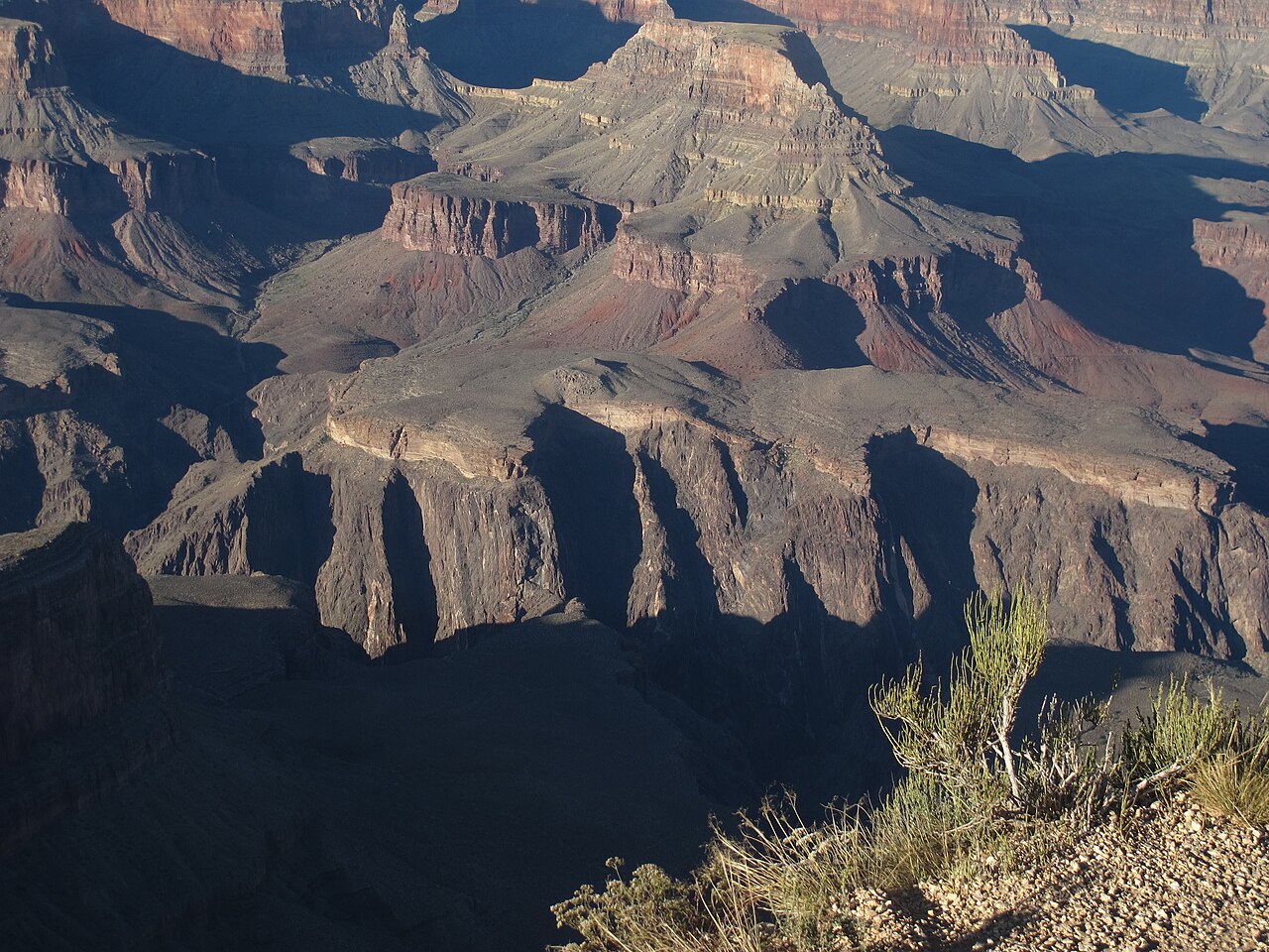
A nonconformity is the most fundamental type: it is the contact where sedimentary rocks rest directly upon crystalline basement — either igneous rocks such as granite or metamorphic rocks such as schist or gneiss. These are the deepest possible unconformities, recording events that reached all the way down to the roots of ancient mountain belts. A nonconformity implies that crystalline rocks formed at depth under conditions of high temperature and pressure were eventually exhumed by prolonged erosion, exposed at the surface, and then buried by sediment as the region subsided and a new depositional cycle began. The time gap represented by a nonconformity can be extraordinarily large, because the crystalline rocks themselves may be ancient and because the exhumation and re-burial cycle requires substantial geological time. The contact between Precambrian crystalline basement and overlying Cambrian sediments exposed in the inner gorge of the Grand Canyon is a classic nonconformity, representing roughly 1.2 billion years of missing record.5, 6
How unconformities form
The formation of an unconformity requires the disruption of a depositional system, either by the cessation of sediment accumulation or, more commonly, by erosion of previously deposited material. In either case, the triggering mechanism is almost always a change in the balance between accommodation — the space available for sediment to accumulate — and sediment supply. When accommodation is destroyed faster than sediment can fill it, the depositional surface rises above base level and erosion commences.8, 9
The most straightforward mechanism is eustatic sea-level fall. When global sea level drops, continental shelves that were previously submerged become exposed, and rivers begin cutting into and eroding the sediments that had accumulated there. The lower the sea level, the farther seaward the shoreline migrates and the more extensive the area of erosion. When sea level subsequently rises again — through thermal expansion of ocean waters, melting of ice sheets, or changes in the volume of mid-ocean ridges — the sea transgresses back across the eroded surface, and new sediments are deposited on it. The resulting contact is a disconformity or, if earlier deformation had tilted the underlying strata, an angular unconformity.8, 9
Tectonic uplift provides a second, often more powerful mechanism. When continental crust is thickened by collision or compressed by regional tectonic forces, it rises isostatically, bringing deep rocks toward the surface. The elevated terrain becomes a zone of erosion rather than deposition. Over millions to hundreds of millions of years, entire mountain ranges can be eroded to near-flat surfaces — called peneplains — that then subside as the tectonic forces relax and the crust cools. Sediments deposited on such surfaces rest unconformably on the deeply eroded remnants of the former mountain belt, and the strata of the mountain belt itself, now tilted and truncated, appear beneath the unconformity. This is precisely the history recorded at Siccar Point, and it is repeated at angular unconformities around the world wherever ancient orogens have been exhumed and re-buried.1, 15
Glacial erosion represents a third mechanism of particular importance for understanding the deepest and most widespread unconformities in Earth history. Continental ice sheets are extraordinarily powerful erosional agents: a glacier hundreds of meters thick resting on crystalline rock can abrade and pluck material at rates that, over millions of years of glaciation, remove kilometers of overlying strata.13 The hypothesis that Snowball Earth glaciations were responsible for the near-global Great Unconformity rests on precisely this mechanism: if ice sheets covered the entire planet’s continents during the Cryogenian, then the erosion they performed would have been global in extent and roughly synchronous in timing, producing a nearly worldwide erosion surface that would be recognized everywhere as an unconformity of approximately the same age.6, 7
Famous examples
The Great Unconformity at the Grand Canyon is the most studied and celebrated unconformity in the world. First formally described by the American geologist John Wesley Powell in 1882 — who named it and recognized its continental significance — the Great Unconformity separates Precambrian crystalline basement and tilted Proterozoic metasediments (the Grand Canyon Supergroup) from overlying flat-lying Cambrian sandstones of the Tapeats Formation.5 The time gap represented by this surface varies across the canyon: where the Tapeats rests directly on Vishnu Schist, dated at approximately 1.74 billion years, the gap is close to 1.2 billion years — a span longer than the entire Phanerozoic Eon.6, 14 The surface itself is remarkably flat, suggesting prolonged and deep erosion before the Cambrian sea transgressed. Geochemical and detrital zircon analyses of the Tapeats sandstone and the basement below have become central to modern debates about whether Snowball Earth glaciation was responsible for the erosion that created the surface.6
The sub-Cambrian peneplain of Scandinavia is in many respects the European equivalent of the Great Unconformity. Across Scandinavia, the Baltic Shield, and adjacent regions, a remarkably planar erosion surface separates Precambrian crystalline basement from overlying Cambrian sediments. The surface is so flat over such a vast area that it preserves the geometry of a continental-scale peneplain — a land surface worn to near-base-level by prolonged erosion — and it has been studied as a type example of how continental interiors respond to long-term denudation.12 The sub-Cambrian peneplain and the Great Unconformity of North America appear to be broadly correlative in age, and their near-simultaneous formation on separate continents strengthens the hypothesis that a global process — rather than local tectonics — was responsible for both.
Siccar Point, Scotland, though representing a far more modest time gap than the Great Unconformity, remains the most historically significant unconformity in geology. The contact between near-vertical Silurian greywacke (approximately 425 million years old) and overlying Devonian Old Red Sandstone (approximately 370 million years old) represents roughly 55 million years of missing record, during which the Caledonian Orogeny deformed the Silurian sediments and erosion planed them flat.1 The site is now a Site of Special Scientific Interest in Scotland and is recognized by the International Union of Geological Sciences as one of the most important geological heritage sites in the world. Every year, geologists retrace Hutton’s steps along the Berwickshire coast to stand at the contact between two worlds and feel, as Playfair did, the vertigo of deep time.
Identification and dating
Identifying an unconformity in the field requires recognizing evidence of a temporal gap or erosion surface that is not simply a normal depositional contact. The most reliable field indicators include: angular discordance between bedding attitudes above and below a contact; an irregular, undulating surface with preserved paleorelief; the presence of a basal conglomerate immediately above the contact, containing clasts derived from the underlying unit; and evidence of weathering, dissolution, or soil formation on the upper surface of the older unit.4, 17 In carbonate rocks, subaerial exposure surfaces may be marked by dissolution pits, karst features, or calcrete — a pedogenic carbonate crust formed in soils under arid conditions — all of which signal that the rock surface was exposed to weathering before burial.16
In subsurface settings, unconformities are identified using well logs and seismic reflection profiles. On seismic sections, unconformities produce characteristic termination patterns: the reflections of the underlying strata are truncated at the unconformity surface (a pattern called erosional truncation or toplap, depending on the geometry), while the overlying strata onlap the surface from the basin margin. These geometric relationships — the vocabulary of sequence stratigraphy — allow unconformities to be mapped across entire sedimentary basins even where no surface exposures exist.8, 9
Dating an unconformity precisely requires determining the ages of the youngest strata below and the oldest strata above. The age of the rocks immediately below the unconformity gives a maximum age for the surface (the gap cannot be older than the youngest rock that was eroded); the age of the oldest rocks above gives a minimum age (deposition must have resumed by then). The time gap is therefore constrained as lying between these two dates.11 Radiometric dating of volcanic ash layers (tephras) immediately above or below an unconformity can dramatically sharpen these constraints. Biostratigraphic analysis using index fossils provides additional temporal precision in fossiliferous sequences. In Precambrian sequences where fossils are absent or rare, detrital zircon geochronology — dating individual zircon crystals eroded from the basement and incorporated into the overlying sediment — has become an indispensable tool for bracketing the age of ancient unconformities.6
Tectonic and sea-level significance
Unconformities are among the most powerful tools available for reconstructing the tectonic and sea-level history of sedimentary basins and their continental margins. Because the formation of a major unconformity requires either uplift, sea-level fall, or both, the distribution of unconformities in time and space encodes the history of these processes.9 Conversely, the lateral extent and apparent synchroneity of an unconformity can be used to distinguish between tectonically controlled (regional) and eustatically controlled (global) events: a disconformity that can be traced across an entire continent, or across multiple continents, is difficult to explain by local tectonics alone and implies a global or at least hemisphere-scale change in sea level.8
The interregional unconformities bounding the large-scale sedimentary sequences of the North American craton — the Sauk, Tippecanoe, Kaskaskia, and other sequences recognized by Laurence Sloss in his foundational 1963 work — were interpreted as the record of major transgressions and regressions of the epicontinental sea across the stable continental interior, driven by glacioeustatic and tectonic sea-level changes over tens of millions of years.8 These continent-spanning unconformities are the building blocks of what sequence stratigraphy calls “supersequences” or “megasequences,” the largest-scale stratigraphic packages recognized in the rock record. Their boundaries can frequently be correlated, at least approximately, with major events on the geologic time scale — mass extinctions, glaciation events, the opening or closing of seaways — confirming that global changes in Earth’s surface environment leave their signatures in the stratigraphic record as unconformity-bounded packages.9, 11
Unconformities also have direct practical importance in petroleum geology. Hydrocarbon traps frequently form at or near unconformity surfaces: reservoir rocks truncated by an unconformity and overlain by impermeable shales create stratigraphic traps that can hold enormous volumes of oil and gas. The basal Cambrian sandstones overlying the Great Unconformity in various parts of the world have themselves served as reservoir rocks, and the search for their subsurface equivalents has motivated much of the detailed mapping of unconformity surfaces in sedimentary basins worldwide.17
The Great Unconformity problem
Among the most active research questions in modern geology is the origin of the Great Unconformity — specifically, why a surface representing approximately the same temporal gap appears on nearly every continent at roughly the same stratigraphic position, separating Precambrian basement from overlying Cambrian sediments.7 The near-global character of this surface is remarkable: it has been documented in North America, Europe, Australia, Africa, South America, and Antarctica. Wherever geologists drill through the Cambrian cover, they encounter a similar, often flat and deeply scoured surface beneath. The question of what process could have produced such a globally extensive erosion surface at approximately the same time is one of the most consequential unresolved problems in Earth history.
The traditional explanation appealed to a combination of tectonic and eustatic processes: following the breakup of the Rodinia supercontinent in the Neoproterozoic, individual continental fragments were low-lying and prone to erosion; widespread tectonic quiescence meant that little new topography was being created; and a long-term rise in sea level driven by renewed seafloor spreading in the early Cambrian then flooded the eroded continental surfaces, producing the Cambrian transgression that is recorded above the unconformity virtually everywhere.14, 18 This model adequately explains why a widespread unconformity exists at the Precambrian–Cambrian boundary, but it struggles to account for the extraordinary flatness and depth of erosion implied by the surface, which in places has removed kilometers of crustal material.
The Snowball Earth hypothesis offers a compelling alternative.7, 19 Two major glaciations are documented in the Cryogenian period — the Sturtian glaciation, approximately 717–659 million years ago, and the Marinoan glaciation, approximately 650–635 million years ago — during which ice sheets may have extended to equatorial latitudes and covered continental interiors to thicknesses of kilometers. If continental ice sheets of Snowball Earth scale existed over the major cratons for tens of millions of years each, the erosion they would have performed would have been globally extensive, roughly synchronous, and of sufficient magnitude to explain the depth and planarity of the Great Unconformity surface. When the ice retreated and sea levels rose — driven by the extraordinary greenhouse warming that ended each Snowball episode — the sea transgressed rapidly across the scoured continental surfaces, depositing cap carbonates and eventually the basal Cambrian sandstones that overlie the unconformity today.6, 13
A landmark 2019 study by Keller and colleagues used a combination of thermochronology — specifically, the temperature-time histories recorded in the decay products of radioactive elements in basement minerals — to show that the exhumation of Precambrian basement rocks in multiple locations around the world accelerated dramatically during the Cryogenian and early Ediacaran, precisely when the Snowball Earth glaciations would be expected to have removed the overlying rock.6 The thermal histories recorded in apatite and zircon crystals from basement rocks beneath the Great Unconformity are consistent with kilometers of erosion occurring between approximately 717 and 540 million years ago — a window that brackets the Snowball glaciations and the early Cambrian transgression. While the Snowball Earth hypothesis for the origin of the Great Unconformity has not achieved universal acceptance, it has transformed the problem from a stratigraphic curiosity into a central question linking Snowball Earth climate dynamics, continental denudation, and the conditions that set the stage for the Cambrian explosion of animal life.
The incompleteness of the stratigraphic record is a theme that runs throughout all of geology, but it is expressed most starkly in unconformities. Every section is a fragmentary archive, and the pages that are missing — the intervals represented by unconformity surfaces — may in aggregate account for more time than the pages that survive. Recognizing this fundamental limitation, and learning to read it rather than simply lamenting it, was one of the great conceptual achievements of geology as a science. Hutton saw it in a seaside cliff on a summer afternoon, and the discipline has never looked at a contact surface the same way since.
References
Theory of the Earth; or an Investigation of the Laws Observable in the Composition, Dissolution, and Restoration of Land upon the Globe
Sedimentary Geology: Sedimentary Basins, Depositional Environments, Petroleum Geology
The Great Unconformity and associated basal Cambrian strata: toward a refined definition