Overview
- The water cycle is a continuous system in which approximately 505,000 cubic kilometres of water evaporate from the oceans and land surfaces each year, are transported through the atmosphere, and return as precipitation — a process powered almost entirely by solar radiation and modulated by gravity, with residence times ranging from days in the atmosphere to tens of thousands of years in deep groundwater and polar ice sheets.
- Earth's total water inventory of roughly 1.386 billion cubic kilometres is overwhelmingly dominated by the oceans (96.5 percent), with freshwater constituting only about 2.5 percent of the total, of which nearly 69 percent is locked in glaciers and ice caps and roughly 30 percent resides in groundwater — leaving less than 1 percent of all freshwater in the lakes, rivers, and atmosphere that sustain most terrestrial ecosystems.
- Human activities have profoundly altered the water cycle through dam construction that traps roughly 10,000 cubic kilometres in reservoirs, groundwater extraction that exceeds natural recharge in many aquifers worldwide, land-use changes that modify evapotranspiration and runoff patterns, and greenhouse gas emissions that intensify the cycle by increasing atmospheric moisture content by approximately 7 percent per degree Celsius of warming.
The water cycle — also called the hydrological cycle — is the continuous movement of water through Earth's atmosphere, surface, subsurface, and biosphere, driven principally by solar energy and shaped by gravity. Water evaporates from the oceans and land surfaces, is transported through the atmosphere as vapour, condenses into clouds, falls as precipitation, and returns to the oceans through rivers, groundwater flow, and direct runoff, completing a loop that has operated without interruption for more than four billion years.3 Hydrology, the scientific discipline devoted to studying this cycle, investigates the distribution, movement, and quality of water across all of Earth's reservoirs, from the thin film of moisture in unsaturated soil to the vast volumes stored in the deep ocean and in the mineral lattices of mantle rocks hundreds of kilometres below the surface.3, 9
The water cycle is fundamental to virtually every other Earth system process. It powers weathering and erosion that break down rock and shape landscapes, drives the fluvial geomorphology that carves river valleys and builds deltas, regulates climate through latent heat transfer and cloud formation, and sustains all known life. Understanding how water moves through these interconnected reservoirs — and how human activities are altering those movements — is one of the central challenges of modern Earth science.2, 14
Earth's water distribution
Earth holds an estimated 1.386 billion cubic kilometres of water in all forms. The overwhelming majority — approximately 96.5 percent, or 1.335 billion cubic kilometres — resides in the oceans as saline water. Freshwater accounts for only about 2.5 percent of the total inventory, roughly 35 million cubic kilometres, and even this modest fraction is unevenly distributed among reservoirs that differ enormously in their accessibility to human use and ecological function.1, 7
Of Earth's freshwater, approximately 68.7 percent is locked in glaciers, ice caps, and permanent snow cover, with the Antarctic and Greenland ice sheets alone containing about 26.4 million cubic kilometres — enough to raise global sea level by roughly 65 metres if fully melted.1, 23 Groundwater constitutes the next largest freshwater reservoir at about 30.1 percent, amounting to approximately 10.6 million cubic kilometres stored in pore spaces and fractures within rock and sediment beneath the land surface.1, 6, 16 The remaining 1.2 percent of freshwater exists in surface water bodies (lakes, rivers, and wetlands), soil moisture, atmospheric water vapour, and biotic water. Rivers, despite their outsized importance to human civilisation and landscape evolution, contain only about 2,120 cubic kilometres of water at any given moment — a vanishingly small fraction of the global total.7
The concept of residence time — the average duration a water molecule spends in a given reservoir before moving to another — illuminates the dynamic character of these stocks. Water vapour in the atmosphere has a residence time of approximately 9 to 10 days, meaning the entire atmospheric water content is replaced roughly 36 times per year. River water turns over every two to three weeks. Soil moisture persists for one to two months. Deep groundwater, by contrast, can remain in place for thousands to tens of thousands of years, while water locked in the Antarctic ice sheet may have residence times exceeding 100,000 years.3, 4 These vastly different turnover rates mean that perturbations to rapidly cycling reservoirs (atmosphere, rivers) propagate quickly, while changes to slow reservoirs (deep aquifers, ice sheets) accumulate gradually but persist for millennia.
Evaporation, transpiration, and precipitation
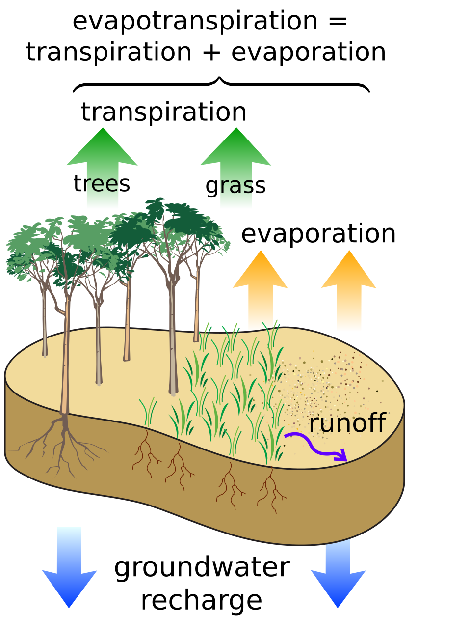
The engine of the water cycle is the phase change of water from liquid to vapour through evaporation and transpiration, powered by solar radiation. Globally, approximately 505,000 cubic kilometres of water evaporate each year, of which about 434,000 cubic kilometres come from the ocean surface and roughly 71,000 cubic kilometres from land surfaces and vegetation.2, 5 Evaporation from the ocean is governed by the temperature difference between the sea surface and the overlying air, the wind speed (which removes the saturated boundary layer above the water), and the relative humidity of the air. Over land, the process is complicated by transpiration — the release of water vapour through the stomata of plants — which is tightly coupled to photosynthesis and accounts for a substantial fraction of total land evaporation. The combined flux of evaporation and transpiration from land surfaces is termed evapotranspiration.3
Once in the atmosphere, water vapour is transported laterally by winds, often over distances of hundreds to thousands of kilometres, before condensing on microscopic aerosol particles (cloud condensation nuclei) to form cloud droplets. The Clausius-Clapeyron relation, a fundamental thermodynamic law, dictates that the saturation vapour pressure of water increases by approximately 7 percent for every 1°C rise in temperature, meaning a warmer atmosphere can hold exponentially more moisture.11 This relationship has profound implications for how the water cycle responds to climate change, as discussed below.
Precipitation occurs when cloud droplets or ice crystals grow large enough to overcome updrafts and fall to the surface. The global mean precipitation rate is approximately 505,000 cubic kilometres per year, balancing evaporation on a long-term average basis. However, precipitation is distributed unevenly between ocean and land: roughly 391,000 cubic kilometres fall over the oceans and about 114,000 cubic kilometres over land.2, 5 The surplus of precipitation over evaporation on land — approximately 43,000 cubic kilometres per year — is the water that feeds rivers, recharges groundwater, and sustains terrestrial ecosystems. This surplus is returned to the ocean through river discharge and direct groundwater outflow, closing the cycle.2
Surface water and drainage basins
Precipitation that reaches the land surface follows several pathways: it may infiltrate into the soil, be intercepted by vegetation, evaporate directly back to the atmosphere, or flow overland as surface runoff. The partitioning among these pathways depends on rainfall intensity, soil type, antecedent moisture conditions, topographic slope, and land cover. When rainfall intensity exceeds the infiltration capacity of the soil — a condition first described by Robert Horton in the 1930s — the excess water flows downhill as overland flow, collecting in rills, channels, and eventually rivers.3 In many environments, however, most streamflow is generated not by overland flow but by subsurface processes: water infiltrates into the soil, moves laterally through shallow saturated zones (throughflow), and emerges into stream channels at the base of slopes or where the water table intersects the surface.3, 13
The fundamental unit of surface hydrology is the drainage basin (also called a watershed or catchment) — the area of land from which all precipitation drains to a common outlet, typically a river mouth or lake. Drainage basins are bounded by topographic divides and range in scale from headwater hollows of a few hectares to continental-scale systems such as the Amazon basin (6.15 million square kilometres), the Congo basin (3.7 million square kilometres), and the Mississippi-Missouri system (3.2 million square kilometres). The discharge of a river at its mouth integrates all the hydrological processes operating within the upstream basin: precipitation, evapotranspiration, infiltration, groundwater exchange, and storage changes in snow, ice, soil, and surface water bodies.3
The world's rivers collectively discharge approximately 37,000 to 42,000 cubic kilometres of freshwater to the oceans annually.2, 7 This discharge is not merely a passive return of excess precipitation; rivers perform enormous geomorphic work, transporting roughly 20 billion tonnes of suspended and dissolved sediment each year under natural conditions.20 The erosive and depositional processes of fluvial geomorphology sculpt valleys, floodplains, alluvial fans, and deltas, making rivers one of the dominant agents of landscape evolution on the continents. Lakes, wetlands, and reservoirs act as storage buffers within drainage basins, attenuating flood peaks, trapping sediment, and modulating the timing and chemistry of river discharge to downstream reaches.3
Groundwater and aquifers
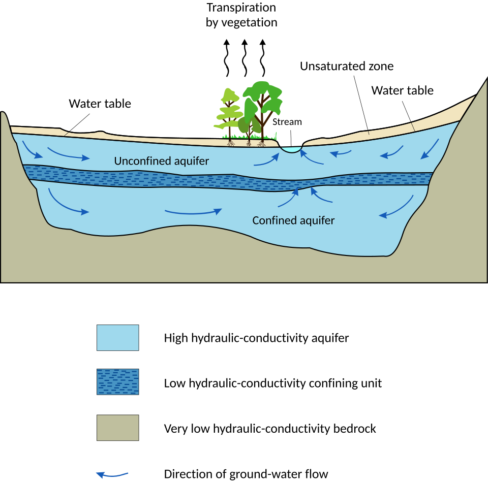
Beneath the land surface, water occupies the pore spaces, fractures, and solution cavities of rock and unconsolidated sediment, forming the vast subterranean reservoir known as groundwater. The boundary between the unsaturated zone (where pore spaces contain both air and water) and the saturated zone (where all pores are completely water-filled) is the water table, whose position fluctuates with recharge from precipitation, discharge to streams and springs, and extraction by wells. Below the water table, saturated geological formations that can store and transmit significant quantities of water are called aquifers.3, 13
Aquifers vary enormously in their properties and productivity. Unconfined aquifers are directly connected to the surface through overlying permeable material and are recharged by downward percolation of precipitation. Confined aquifers are sandwiched between impermeable layers (aquitards or aquicludes) and may be under hydrostatic pressure, causing water to rise above the top of the aquifer when a well is drilled — a condition known as artesian flow. The rate at which water moves through an aquifer depends on the hydraulic conductivity of the geological material (a function of pore size, connectivity, and the fluid's viscosity) and the hydraulic gradient driving flow, as described by Darcy's law, the foundational equation of groundwater hydrology.3
Gleeson et al. (2016) estimated the total volume of modern groundwater — defined as water recharged within the past 50 years — at approximately 0.35 million cubic kilometres globally, a small fraction of total groundwater storage but a quantity of critical importance because it represents the portion most actively connected to surface water systems and most vulnerable to contamination.16 Older, deeper groundwater can have residence times of thousands to millions of years and is often highly mineralised. The interaction between groundwater and surface water is a two-way exchange: streams may gain water from the subsurface (gaining streams) or lose water to it (losing streams), and many rivers transition between these conditions along their length and across seasons.13
Groundwater also discharges directly to the oceans through submarine groundwater discharge — a process long underappreciated but now recognised as a globally significant pathway for water and dissolved chemical fluxes. Luijendijk et al. (2020) estimated total submarine groundwater discharge at roughly 1,500 cubic kilometres per year of freshwater, with an additional component of recirculated seawater through coastal aquifers delivering nutrients, carbon, and trace metals to nearshore marine environments.22
Ocean-atmosphere exchange
The ocean is both the largest source and the largest sink of atmospheric water vapour, and the exchange of water between these two reservoirs drives the energetics of the global climate system. Evaporation from the sea surface requires approximately 2,450 joules per gram of water at typical ocean temperatures — energy drawn from the ocean's thermal reservoir and transported into the atmosphere as latent heat. When this vapour subsequently condenses to form clouds and precipitation, the latent heat is released, warming the atmosphere and powering atmospheric circulation, including tropical convection cells, mid-latitude storm systems, and the Hadley circulation.5
The net transfer of water from ocean to land via the atmosphere — roughly 43,000 cubic kilometres per year — represents a massive distillation system in which the ocean provides the source water, solar energy drives the evaporation, atmospheric dynamics handle the transport, and gravity returns the water to the sea through continental runoff.2 This atmospheric transport of water vapour also carries a latent-heat flux of roughly 78 watts per square metre averaged over the ocean surface, making the water cycle the single largest mechanism of energy transfer from the surface to the atmosphere — exceeding the contributions of both sensible heat transfer and net longwave radiation.5
Ocean circulation and climate are intimately coupled to the water cycle through the thermohaline circulation. The formation of deep water in the North Atlantic and around Antarctica depends critically on the salinity of surface waters, which is itself a product of the balance between evaporation (which removes freshwater and increases salinity) and precipitation plus river runoff (which add freshwater and decrease salinity). Changes in the atmospheric freshwater transport from low to high latitudes can therefore modulate the strength of the overturning circulation, with cascading effects on global heat distribution, sea-ice extent, and atmospheric CO2 concentrations.14
The deep water cycle
The hydrological cycle as traditionally conceived — evaporation, precipitation, runoff, and groundwater flow — operates entirely within the outermost few kilometres of Earth's surface. However, geophysical and geochemical evidence accumulated over the past several decades has revealed that a far deeper water cycle operates within the solid Earth itself, exchanging water between the surface and the mantle through plate tectonics on timescales of hundreds of millions of years.9, 10
Water enters the mantle through subduction, the process by which oceanic lithosphere descends into the deep Earth at convergent plate boundaries. Oceanic crust and the overlying sediment are pervasively hydrated through interaction with seawater at mid-ocean ridges and on the abyssal seafloor. As this material is subducted, increasing pressure and temperature drive a series of metamorphic dehydration reactions that release water into the overlying mantle wedge, lowering the solidus of mantle rock and triggering the partial melting that produces arc volcanism. However, not all water is released at shallow depths; some is carried to greater depths within hydrous minerals such as serpentine, chlorite, and lawsonite, potentially transporting water into the transition zone (410 to 660 kilometres depth) and even the lower mantle.10
The discovery by Pearson et al. (2014) of a terrestrial diamond containing the hydrous mineral ringwoodite with approximately 1.4 weight percent water provided the first direct evidence that the mantle transition zone contains significant quantities of water, stored not as a free liquid but within the crystal structure of high-pressure silicate minerals.9 Schmandt et al. (2014) subsequently presented seismic evidence for partial melting at the base of the transition zone beneath North America, consistent with the release of water from ringwoodite as it transforms to the lower-mantle assemblage of bridgmanite and ferropericlase at the 660-kilometre discontinuity.10 Estimates of the water storage capacity of the transition zone suggest it could hold one to three times the volume of the surface oceans, although the actual water content remains poorly constrained.9, 17
Water returns to the surface through volcanic degassing at mid-ocean ridges, subduction zone volcanoes, and hotspot volcanoes, closing the deep cycle on geological timescales. The balance between subduction-driven ingestion and volcanic outgassing has likely fluctuated through Earth's history, influencing ocean volume, sea level, and the oxidation state of the mantle. During the Archean and early Proterozoic, more vigorous mantle convection and faster plate velocities may have driven more rapid cycling of water through the interior, potentially affecting the volume of the surface ocean and the area of exposed continental crust — conditions with direct implications for the earliest development of life and the evolution of Earth's atmosphere.10
Isotope hydrology and tracing water
The stable isotopes of hydrogen (protium 1H and deuterium 2H, or D) and oxygen (16O and 18O) are among the most powerful tools for tracing the movement of water through the hydrological cycle. Because heavier isotopologues (HDO, H218O) have lower vapour pressures and diffuse more slowly than lighter ones, each phase change — evaporation, condensation, sublimation, melting — fractionates the isotopic composition of the remaining water. This fractionation produces systematic spatial and temporal patterns in the isotopic composition of precipitation, groundwater, and surface water that can be used to identify water sources, determine mixing proportions, estimate recharge rates, and reconstruct past climate conditions.4
The Global Meteoric Water Line, first defined by Harmon Craig in 1961, describes the empirical linear relationship δD = 8δ18O + 10 between the deuterium and oxygen-18 composition of precipitation worldwide. Deviations from this line — expressed as deuterium excess — provide information about the evaporation conditions at the moisture source and about secondary evaporation processes during rainfall. Precipitation becomes progressively more depleted in heavy isotopes with increasing latitude, altitude, continentality (distance from the ocean), and decreasing temperature, a series of systematic effects that make isotopes invaluable for fingerprinting water origin and for paleoclimate reconstruction from ice cores, speleothems, and lacustrine carbonates.4
Radioactive isotopes complement stable isotope tracers by providing direct estimates of water age and residence time. Tritium (3H), produced naturally by cosmic ray interactions and injected in large quantities into the atmosphere by thermonuclear weapons testing in the 1950s and 1960s, decays with a half-life of 12.3 years and is used to identify groundwater recharged within the past several decades. Carbon-14, with a half-life of 5,730 years, can date groundwater up to approximately 40,000 years old. Together, these tracers reveal the timescales over which different parts of the hydrological cycle operate and help distinguish renewable groundwater resources from fossil water that was recharged under different climatic conditions thousands of years ago.4, 8
Paleoclimate and the water cycle
The water cycle has varied dramatically over Earth's history in response to changes in solar luminosity, atmospheric composition, continental configuration, and orbital parameters. Paleoclimate archives including ice cores, ocean sediment cores, speleothems, lake sediments, and tree rings preserve proxy records of past precipitation, evaporation, and atmospheric moisture transport that reveal how the hydrological cycle has operated under conditions radically different from the present.18, 19
During the ice ages and glaciation of the Pleistocene, the water cycle was profoundly reorganised. At the Last Glacial Maximum, approximately 21,000 years ago, roughly 52 million cubic kilometres of additional water were locked in continental ice sheets, lowering global sea level by about 120 to 130 metres. This transfer of water from ocean to ice reduced oceanic evaporation, diminished atmospheric moisture content, and shifted precipitation belts equatorward.18, 23 The oxygen isotope record from Antarctic ice cores — extending back 800,000 years in the EPICA Dome C core — documents the rhythmic oscillation of the water cycle between glacial and interglacial states, paced by Milankovitch orbital variations but amplified by feedback processes involving ice albedo, atmospheric CO2, and vegetation changes.18, 19
On longer timescales, tectonic processes have exerted first-order control over the water cycle by rearranging continents, opening and closing seaways, and building mountain ranges that intercept atmospheric moisture. The uplift of the Himalaya and the Tibetan Plateau, for example, intensified the Asian monsoon system by creating an elevated heat source that strengthens the seasonal pressure gradient between the continent and the Indian Ocean. The closure of the Isthmus of Panama approximately 3 to 4 million years ago altered Atlantic salinity patterns and moisture transport, contributing to the intensification of Northern Hemisphere glaciation.14 During the extreme greenhouse conditions of the early Eocene thermal maximum, approximately 56 million years ago, the hydrological cycle was dramatically intensified, with enhanced tropical precipitation, expanded subtropical arid zones, and increased chemical weathering rates that may have helped draw down excess atmospheric CO2 through silicate weathering feedbacks.14
Anthropogenic impacts on the water cycle
Human activities have altered nearly every component of the water cycle, in many cases at rates and scales that rival or exceed natural variability. The most direct interventions include the construction of large dams, the extraction of groundwater, the diversion of rivers for irrigation, and the transformation of land surfaces through agriculture and urbanisation. More indirectly, greenhouse gas emissions are intensifying the entire hydrological cycle by warming the atmosphere and increasing its capacity to hold moisture.14
Dam construction has fundamentally altered the movement of water and sediment through river systems. More than 58,000 large dams (defined as those exceeding 15 metres in height) have been built worldwide, collectively impounding roughly 10,000 cubic kilometres of water in reservoirs and trapping an estimated 25 to 30 percent of the global sediment flux that would otherwise reach the oceans.12, 20 The hydrological consequences include altered flow regimes downstream (with reduced flood peaks and elevated base flows), changed patterns of evaporation from the expanded water surfaces of reservoirs, and disrupted connectivity between rivers and their floodplains. Syvitski et al. (2005) estimated that human activities have simultaneously increased erosion rates through land-use change and decreased sediment delivery to the coast through dam trapping, producing a net reduction in sediment reaching the ocean despite higher erosion in headwater regions.20
Groundwater extraction has become one of the most consequential human modifications of the water cycle. Global groundwater withdrawals total approximately 1,000 cubic kilometres per year, of which a large fraction is non-renewable depletion — extraction that exceeds natural recharge rates. Wada et al. (2010) estimated global groundwater depletion at roughly 283 cubic kilometres per year, concentrated in the major agricultural regions of northern India, the North China Plain, the central United States (the High Plains Aquifer), Iran, and Saudi Arabia.15 The water removed from aquifers is ultimately transferred to the surface hydrological cycle, where it evaporates or flows to the ocean, contributing an estimated 0.4 millimetres per year to sea-level rise.15, 24
Land-use change modifies the water cycle by altering evapotranspiration, infiltration, and runoff generation. Deforestation reduces transpiration and interception, typically increasing total runoff and peak flows while decreasing dry-season baseflow. Urbanisation replaces permeable soils with impervious surfaces, dramatically increasing the speed and volume of storm runoff while reducing infiltration and groundwater recharge. Agricultural irrigation represents a massive interbasin and interreservoir transfer of water: approximately 2,700 cubic kilometres per year are withdrawn for irrigation globally, much of it from groundwater or rivers in one basin and applied to fields where it evaporates or infiltrates into a different part of the hydrological system.2, 14
The overarching anthropogenic influence on the water cycle, however, is climate change driven by greenhouse gas emissions. As the atmosphere warms, the Clausius-Clapeyron relation dictates an increase of approximately 7 percent in atmospheric moisture content per degree Celsius, a prediction that has been observationally confirmed over the satellite era.11, 21 This moistening intensifies the hydrological cycle: evaporation increases over the oceans, precipitation events become more intense (because more moisture is available for condensation), and the contrast between wet and dry regions sharpens — a pattern summarised as "wet regions get wetter, dry regions get drier."14 The IPCC Sixth Assessment Report concluded with high confidence that human influence has driven observed changes in the global water cycle since the mid-twentieth century, including intensification of heavy precipitation events, changes in monsoon patterns, and acceleration of ice-sheet mass loss that transfers water from the cryosphere to the ocean.14
The interaction between these anthropogenic perturbations creates compound risks. Groundwater depletion reduces the buffering capacity of aquifers during drought. Land-use change amplifies flood peaks in urbanised catchments. Climate-driven intensification of the water cycle increases both flood and drought extremes in a warming world. Dam-induced sediment starvation accelerates coastal erosion and subsidence, compounding the effects of sea-level rise driven by thermal expansion and ice-sheet melt.12, 14, 20 Understanding the water cycle as an integrated system — one in which changes to any component propagate through every other — is essential to anticipating and managing these interconnected challenges in the decades ahead.
References
Estimates of the global water budget and its annual cycle using observational and model data
Depletion and response of deep groundwater to climate-related transient storage change
Anthropogenic sediment retention: major global impact from registered river impoundments
Climate and atmospheric history of the past 420,000 years from the Vostok ice core, Antarctica