Overview
- The Mississippian culture (c. 800–1600 CE) was the most complex pre-Columbian society in North America north of Mexico, characterized by large-scale maize agriculture, shell-tempered pottery, ranked chiefdom-level political organization, and the construction of monumental earthen platform mounds across the southeastern and midcontinental United States.
- Cahokia, located near present-day St. Louis, was the largest Mississippian centre and the biggest pre-Columbian city north of Mexico, with a peak population estimated at 10,000–20,000 people around 1050–1200 CE and more than 120 earthen mounds including Monks Mound, the largest earthwork in the Americas at approximately 30 metres tall.
- Mississippian polities declined through a combination of climatic instability, prolonged drought, warfare, resource depletion, and — after 1500 CE — the catastrophic impact of European-introduced diseases, leading to the abandonment of major centres such as Cahokia by 1400 CE and the transformation of surviving communities into the historically documented Native American nations of the Southeast.
The Mississippian culture was the most extensive and politically complex pre-Columbian civilisation in North America north of Mexico, flourishing from approximately 800 to 1600 CE across the river valleys and floodplains of the southeastern and midcontinental United States.1, 20 Defined archaeologically by the convergence of intensive maize agriculture, shell-tempered pottery, ranked social hierarchies, and the construction of monumental earthen platform mounds, the Mississippian tradition encompassed hundreds of autonomous and semi-autonomous polities distributed from the Great Lakes to the Gulf Coast and from the Atlantic seaboard to the edge of the Great Plains.1, 15 The largest and most influential of these polities was Cahokia, located in the American Bottom floodplain of the Mississippi River near present-day St. Louis, Missouri, which by 1050 CE had grown into the biggest urban centre on the continent, with a population estimated between 10,000 and 20,000 and a monumental landscape of more than 120 earthen mounds.1, 2, 14 Designated a UNESCO World Heritage Site in 1982, Cahokia and the broader Mississippian tradition represent a critical chapter in the history of complex societies, demonstrating that large-scale urbanism, long-distance exchange, and hierarchical political organisation emerged independently in the temperate woodlands of eastern North America.14, 20
Origins and defining characteristics
The emergence of the Mississippian tradition was not a single event but a gradual coalescence of cultural traits that archaeologists recognise through a cluster of material markers: shell-tempered pottery, wall-trench house construction, platform mound architecture, and the intensification of maize-centred agriculture.1, 15 These traits first appeared in the central Mississippi River valley and the American Bottom region during the Late Woodland period (c. 600–900 CE), when local populations began supplementing their traditional diet of native seed crops — chenopodium, sunflower, marsh elder, and squash — with increasing quantities of maize (Zea mays) imported from Mesoamerica via networks of exchange that had been operating for centuries.1, 20 The shift to maize-dominated agriculture, confirmed by stable isotope analysis of human skeletal remains showing elevated δ13C values, was transformative: maize provided storable caloric surpluses sufficient to support larger, more sedentary populations and the social hierarchies that emerged to manage surplus production and distribution.1, 18
Shell-tempered pottery — ceramic vessels in which crushed freshwater mussel shell replaced earlier grit, sand, or grog temper — became the signature technological marker of the Mississippian world.15, 20 Shell tempering produced thinner, lighter, more durable vessels with superior thermal conductivity, making them ideal for the prolonged cooking required to process maize into hominy and other staple foods.15 The rapid spread of this technology across the Southeast after approximately 900 CE serves as one of the primary archaeological tracers for the expansion of Mississippian cultural practices, though scholars debate whether this spread reflects population movement, the diffusion of ideas through trade networks, or some combination of both.1, 10
Platform mound construction was the most visible expression of Mississippian social and political organisation.20 Unlike the conical burial mounds built by earlier Adena and Hopewell cultures, Mississippian platform mounds were flat-topped, rectangular or square earthworks that served as elevated foundations for the residences of chiefs, temples, council houses, and mortuary structures.1, 20 Mounds were typically arranged around a central plaza that functioned as the civic and ceremonial heart of the community, a spatial pattern that was replicated with remarkable consistency across the Mississippian world from Cahokia to the smallest single-mound settlements.1, 18
Cahokia: the great metropolis
Cahokia, situated on the broad floodplain of the American Bottom where the Missouri, Illinois, and Mississippi rivers converge, was the pre-eminent centre of the Mississippian world and the largest pre-Columbian settlement north of the Rio Grande.1, 2 The site's transformation from a modest Late Woodland village into a sprawling urban centre occurred with extraordinary rapidity during what archaeologists call the Lohmann phase (c. 1050–1100 CE), when population surged from an estimated 1,400–2,800 to between 10,200 and 15,300 in the space of a few decades — a demographic explosion that Timothy Pauketat has described as a deliberate, politically orchestrated "big bang."1, 2 Strontium isotope analysis of teeth from Cahokia burials has confirmed that a significant proportion of this population growth resulted from immigration, with people arriving from diverse geological regions across the midcontinent.9
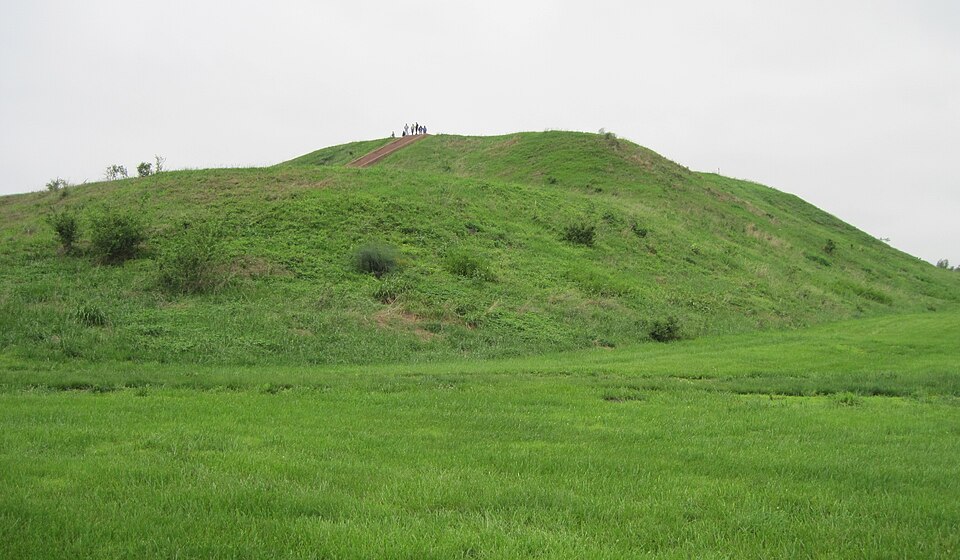
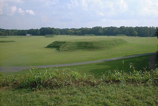
The centrepiece of Cahokia's monumental landscape was Monks Mound, the largest earthen construction in the Americas.4, 14 Rising approximately 30 metres above the surrounding floodplain and covering an area of more than 5.6 hectares at its base, Monks Mound was constructed in multiple stages using three distinct techniques: basket-loaded fill of mixed clays and sandy soils, stacked sod blocks, and scattered earth deposits.4, 5 Recent Bayesian chronological modelling of radiocarbon dates suggests that the bulk of the mound was built in two rapid construction episodes between approximately 1050 and 1200 CE, far more quickly than the 250-year timeline proposed by earlier researchers.4, 5 The summit of Monks Mound supported a large wooden building, likely the residence or audience hall of Cahokia's paramount chief, positioned to command views of the Grand Plaza, a levelled and partially filled open space of roughly 19 hectares that could accommodate thousands of people for ceremonies and public events.1, 2
Cahokia's broader landscape included more than 120 mounds of various sizes and functions, a series of large circular arrangements of wooden posts (dubbed "Woodhenge" by archaeologists) that served as solar observatories for marking solstices and equinoxes, and a defensive wooden palisade with regularly spaced bastions that enclosed approximately 120 hectares of the site's central precinct.1, 2, 18 The construction of the palisade, which was rebuilt at least four times, indicates both the scale of organised labour that Cahokian elites could mobilise and the increasing concerns about warfare and security that characterised later phases of the site's occupation.18, 17
Political and social organisation
Mississippian societies were organised as chiefdoms — ranked polities in which ascribed social inequality was institutionalised and political authority was concentrated in hereditary leaders who combined secular and sacred roles.1, 3, 15 At the apex of the social hierarchy stood the paramount chief, who resided atop the principal platform mound and served as the primary intermediary between the community and the supernatural forces believed to govern agricultural fertility, warfare, and cosmic order.18, 11 Below the chief were ranked lineages of nobles, followed by commoners and, in some polities, subordinate populations who may have occupied positions analogous to those of attached specialists or captives.1, 15
The degree of political centralisation varied significantly across the Mississippian world. Network analysis of ceramic exchange patterns and site hierarchies has revealed that some polities, including Cahokia, Moundville, and Etowah, developed strongly centralised, vertically integrated political structures, while others operated through more diffuse, horizontally networked arrangements in which multiple chiefs of roughly equal status maintained power through alliance and competition rather than subordination.10 Pauketat has argued that Cahokia's political organisation transcended the conventional chiefdom model, exhibiting characteristics more typical of early states, including urban planning, labour corvées, craft specialisation, and an ideological apparatus capable of integrating diverse immigrant populations into a shared political community.3, 1
Mortuary practices provide the most direct archaeological evidence for social stratification. At Cahokia's Mound 72, excavations uncovered a series of elaborate burials that vividly illustrate the extremes of Mississippian inequality.8, 21 The central burial, traditionally interpreted as a paramount chief, was interred on a platform of more than 20,000 marine shell beads alongside retainers, caches of finely crafted projectile points, mica sheets, and copper ornaments.21 Surrounding this central feature were mass graves containing at least 272 individuals, many of them young women between 15 and 25 years of age who appear to have been sacrificed as part of funerary rituals.8, 21 Dental morphology and strontium isotope analysis indicate that most of these individuals were local to the Cahokia region rather than foreign captives, challenging earlier assumptions about the origins of sacrificial victims.8
The Southeastern Ceremonial Complex
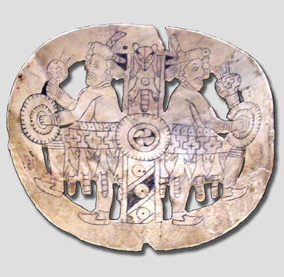
The Southeastern Ceremonial Complex (SECC), formerly known as the "Southern Cult," refers to a widely shared system of iconographic motifs, ritual objects, and ceremonial practices that linked Mississippian polities across the Southeast from approximately 1200 to 1450 CE.11
SECC iconography appears on a range of prestige goods — engraved marine shell gorgets and cups, embossed copper plates, carved stone effigy pipes, and painted ceramics — found in elite contexts at major centres including Cahokia, Etowah, Moundville, and Spiro.11, 13 Recurring motifs include the forked eye, the bi-lobed arrow, the feathered serpent, the sun circle, the cross-in-circle, and costumed warrior figures often identified with the mythological culture hero known in later Southeastern Native American traditions as the "Birdman" or "Falcon Warrior."11, 18
Rather than representing a single unified religion, the SECC is now understood as a constellation of overlapping regional traditions that shared a common symbolic vocabulary rooted in widespread Southeastern cosmological beliefs about the upper world, the middle world, and the beneath world.11 These symbols and the prestige goods on which they appeared served as instruments of chiefly authority: the ability to obtain, display, and ritually deploy SECC objects signalled a chief's connections to distant centres of power and to the supernatural forces that legitimised political hierarchy.11, 18 The distribution of SECC objects across the Southeast thus maps not only an iconographic tradition but a political geography of alliance, exchange, and competition among Mississippian elites.10, 11
Major regional centres
Although Cahokia was the largest and earliest major Mississippian centre, the tradition produced a constellation of important polities across the Southeast, each adapting the core Mississippian pattern to local environmental and social conditions.1, 20
Moundville, located on the Black Warrior River in west-central Alabama, was the second-largest Mississippian site and one of the most intensively studied.12, 20 Established around 1000 CE, Moundville grew to encompass approximately 29 mounds arranged in a planned oval around a central plaza, covering some 75 hectares.12 At its height between 1200 and 1350 CE, the site functioned as both a residential centre and a necropolis, with elite burials concentrated in the mounds and commoner burials in surrounding areas, a spatial pattern that archaeologists interpret as a physical map of the social hierarchy.12, 20 After approximately 1350 CE, Moundville's residential population declined sharply, and the site transitioned into a primarily ceremonial and mortuary centre serving dispersed rural communities in the surrounding valley.12
Etowah, situated on the Etowah River in northwest Georgia, was the principal Mississippian centre of the South Appalachian region.19 The site contains six mounds, including three large platform mounds, arranged around two plazas, and was occupied from approximately 1000 to 1550 CE through several cycles of growth, abandonment, and reoccupation that reflect the volatile political dynamics of Mississippian chiefdoms.19 Etowah is renowned for the quality of its SECC-related artefacts, including elaborately embossed copper plates depicting costumed warrior figures, finely carved marble statuary, and engraved shell gorgets recovered from elite mortuary contexts in Mound C.11, 19
Spiro, located on the Arkansas River in eastern Oklahoma, occupied a position at the western frontier of the Mississippian world.13 The site is most famous for its Craig Mound, a hollow-chambered mortuary structure that preserved an extraordinary concentration of SECC artefacts, including engraved conch shell cups, carved cedar masks, embossed copper plates, and textiles, in better condition than comparable finds from any other Mississippian site.13 Tragically, much of the Craig Mound was commercially looted by a mining company in the 1930s before professional archaeologists could excavate, though subsequent work recovered thousands of objects that have proved invaluable for understanding Mississippian iconography and interregional exchange.13
Major Mississippian centres by approximate peak population and mound count1, 12, 19, 13, 20
| Site | Location | Peak period (CE) | Est. peak population | Mound count |
|---|---|---|---|---|
| Cahokia | Illinois | 1050–1200 | 10,000–20,000 | 120+ |
| Moundville | Alabama | 1200–1350 | 1,000–3,000 | 29 |
| Etowah | Georgia | 1200–1375 | 3,000–5,000 | 6 |
| Spiro | Oklahoma | 1200–1450 | Unknown | 12 |
| Winterville | Mississippi | 1200–1400 | 1,000+ | 23 |
| Angel Mounds | Indiana | 1100–1450 | 1,000+ | 11 |
Economy and subsistence
The economic foundation of Mississippian societies rested on the intensive cultivation of maize, beans, and squash — the "Three Sisters" complex — supplemented by hunting, fishing, and the gathering of wild plant foods.1, 15 Maize was the dominant crop, providing the caloric surplus necessary to support dense, sedentary populations and the non-agricultural specialists (potters, builders, ritual practitioners) attached to chiefly households.1, 18 Fields were typically located on the fertile alluvial soils of river floodplains, which were naturally renewed by seasonal flooding, reducing the need for fallowing or soil amendment.15 Archaeological evidence from flotation samples and residue analysis of cooking vessels indicates that maize was processed in multiple ways, including as hominy (maize treated with lye to release niacin), ground meal, and parched kernels.15, 20
Long-distance exchange was a critical component of the Mississippian political economy, though its character differed from the market-based trade of Mesoamerican civilisations.15, 10 Exotic prestige goods — marine shell from the Gulf Coast, copper from the Great Lakes, mica from the Appalachians, galena from the upper Mississippi valley, and chert from specialised quarries — circulated through elite-controlled networks of gift exchange, tribute, and alliance-building.11, 15 These materials were transformed by craft specialists into the ritual objects and status markers that sustained chiefly authority, while utilitarian goods such as salt, stone hoe blades, and pottery moved through more diffuse channels of local and regional exchange.12, 15
Decline and transformation
The decline of Mississippian polities was neither simultaneous nor uniform, but unfolded across several centuries through a complex interplay of environmental, political, and demographic factors.6, 7, 16 Cahokia itself began to contract during the Moorehead phase (c. 1200–1350 CE), when population declined from its Stirling-phase peak and the monumental palisade was erected around the central precinct, suggesting increased social stress and security concerns.17, 18 By approximately 1400 CE, Cahokia and the surrounding American Bottom had been largely abandoned, and the region became part of what archaeologists call the "Vacant Quarter" — a broad zone of depopulation extending across the confluence region of the Ohio and Mississippi rivers.16
Paleoenvironmental research has increasingly implicated climatic instability as a contributing factor. Analysis of fecal stanols preserved in Horseshoe Lake sediments near Cahokia documented simultaneous flooding events and seasonal precipitation changes that correlated with periods of population decline during the thirteenth century.7 A subsequent study of oxygen isotope ratios in the same sediment core identified a severe and prolonged drought between approximately 1250 and 1400 CE, coinciding with the Little Ice Age, that would have devastated maize yields in the American Bottom and surrounding regions.6 These environmental pressures, combined with soil depletion from centuries of intensive maize cultivation, likely undermined the agricultural surpluses on which chiefly authority depended.6, 7
The arrival of European explorers and colonists after 1500 CE introduced an additional and ultimately catastrophic factor: epidemic disease.20 The expeditions of Hernando de Soto (1539–1543) and other early European explorers traversed the heart of the Mississippian Southeast, encountering still-functioning chiefdoms at sites such as Cofitachequi and Coosa, but also spreading pathogens — smallpox, measles, influenza — against which Indigenous populations had no acquired immunity.20 The demographic collapse that followed, estimated by some scholars at 75 to 90 per cent population loss over the sixteenth and seventeenth centuries, shattered the surviving Mississippian chiefdoms and contributed to the coalescence of new political entities — the historically documented Chickasaw, Choctaw, Cherokee, Creek (Muscogee), and Natchez nations — whose oral traditions, cosmological beliefs, and material culture preserve recognisable continuities with their Mississippian antecedents.15, 20
Legacy and significance
The Mississippian tradition holds a singular place in the archaeology of North America as the most complex indigenous society to develop north of Mexico without the stimulus of direct contact with Mesoamerican state-level civilisations.1, 20 Cahokia's designation as a UNESCO World Heritage Site in 1982 recognised the global significance of the Mississippian achievement, and ongoing archaeological research continues to refine understanding of the tradition's origins, political dynamics, and legacy.14 The descendants of Mississippian peoples — the modern federally recognised tribes of the Southeastern United States — maintain cultural and spiritual connections to the mound sites, and collaborative partnerships between archaeologists and tribal communities have become increasingly important in shaping research priorities and interpretive frameworks.20
Mississippian archaeology also contributes to broader comparative debates about the nature of complex societies, urbanism, and political authority.3, 10 Cahokia's rapid urban emergence, its reliance on immigrant labour, and its eventual abandonment offer instructive parallels and contrasts with early cities in Mesopotamia, the Indus Valley, and Mesoamerica, reminding scholars that the pathways to social complexity were multiple and that the centralised, monument-building polity was not a uniquely Old World phenomenon.1, 3, 20 At the same time, the Mississippian record serves as a powerful corrective to the long-standing erasure of Indigenous North American civilisational achievement from popular historical narratives — a legacy of nineteenth-century "Mound Builder" myths that attributed the earthworks to lost races rather than to the ancestors of living Native American peoples.20
References
Severe Little Ice Age Drought in the Midcontinental United States during the Mississippian Abandonment of Cahokia
Fecal Stanols Show Simultaneous Flooding and Seasonal Precipitation Change Correlate with Cahokia’s Population Decline
New Dental and Isotope Evidence of Biological Distance and Place of Origin for Mass Burial Groups at Cahokia’s Mound 72
Immigrants at the Mississippian Polity of Cahokia: Strontium Isotope Evidence for Population Movement
The Social Networks and Structural Variation of Mississippian Sociopolitics in the Southeastern United States
The Vacant Quarter Revisited: Late Mississippian Abandonment of the Lower Ohio Valley