Overview
- The ocean floor is composed of a layered sequence of basalt, gabbro, and upper-mantle peridotite that forms continuously at mid-ocean ridges through seafloor spreading, producing symmetric magnetic anomaly stripes that provided decisive evidence for plate tectonics.
- Major physiographic provinces of the ocean floor include mid-ocean ridges, abyssal plains, oceanic trenches, seamounts, and hydrothermal vent fields, each reflecting distinct tectonic and magmatic processes that shape over 60 percent of Earth's solid surface.
- Sediment distribution on the ocean floor follows systematic patterns controlled by distance from continental sources, biological productivity, water depth relative to the carbonate compensation depth, and crustal age, recording a continuous archive of Earth's climatic and tectonic history.
The ocean floor covers approximately 361 million square kilometres, more than 70 percent of Earth's surface, yet remained almost entirely unknown until the mid-twentieth century.1 Systematic mapping by sonar during and after the Second World War revealed that the seafloor is not a featureless plain but a landscape of towering volcanic ridges, vast flat abyssal plains, deep trenches, and thousands of submarine mountains. The geological study of this terrain transformed Earth science: the discovery that new oceanic crust forms continuously at mid-ocean ridges, spreads laterally, and is ultimately consumed at subduction zones provided the observational foundation for the theory of plate tectonics.1, 2 Ocean floor geology encompasses the structure, composition, and age of oceanic crust, the processes that create and destroy it, and the sedimentary record that accumulates on top of it over tens of millions of years.
Structure and composition of oceanic crust
Oceanic crust is fundamentally different from continental crust in composition, thickness, and age. It is thin (typically 6 to 7 kilometres), dense (averaging about 3.0 g/cm3), and young — no oceanic crust older than approximately 200 million years survives on the modern seafloor, because older crust has been recycled into the mantle at subduction zones.4, 18 The internal structure of oceanic crust was established through a combination of seismic refraction studies, deep-sea drilling, and the examination of ophiolites — slices of ancient oceanic lithosphere that have been thrust onto continental crust and are accessible at the surface.17
The classic model, refined over decades of ocean drilling and seismic work, recognises a layered sequence. Layer 1 consists of pelagic and hemipelagic sediment, variable in thickness from essentially zero at the ridge axis to hundreds of metres on old crust far from the ridge. Layer 2 is composed of basaltic lavas, principally pillow basalts erupted onto the seafloor (Layer 2A) underlain by a sheeted dyke complex of vertical basalt intrusions (Layer 2B). Layer 3, the thickest layer, consists of gabbro — the coarse-grained, slowly cooled plutonic equivalent of basalt, crystallised in a magma chamber beneath the ridge axis.4, 5 Beneath the gabbroic layer lies the Mohorovicic discontinuity (Moho), marking the transition to the upper mantle, which is composed of peridotite, an ultramafic rock dominated by the mineral olivine. The entire assemblage — sediment, basalt, gabbro, and uppermost mantle peridotite — forms the oceanic lithosphere.4, 17

_35_(33387335028).jpg)
The chemical composition of the basalts erupted at mid-ocean ridges is remarkably uniform worldwide. These mid-ocean ridge basalts (MORB) are tholeiitic basalts depleted in incompatible trace elements relative to the bulk Earth, reflecting their derivation by partial melting of a mantle source that has already been depleted by previous melting events over Earth's history.11 The homogeneity of MORB chemistry across different ocean basins demonstrates that the upper mantle source region is well mixed on a global scale, a finding with implications for mantle convection and the chemical evolution of the Earth.4, 11
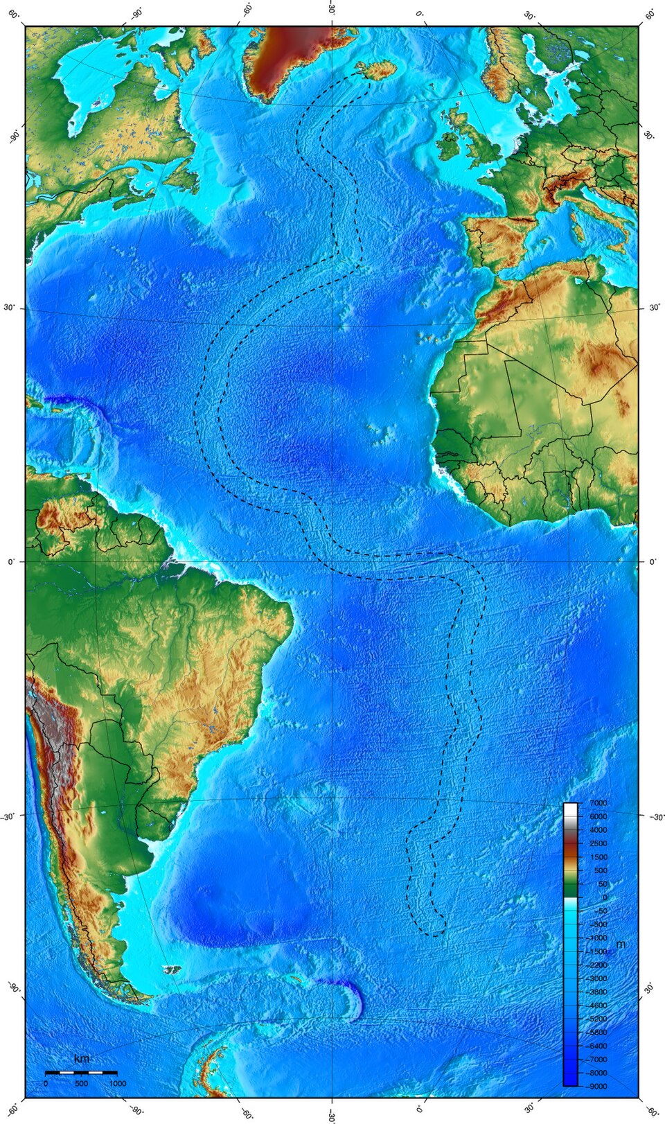
Mid-ocean ridges
The global mid-ocean ridge system is the longest mountain chain on Earth, extending approximately 65,000 kilometres through all the major ocean basins. It marks the divergent plate boundaries where new oceanic lithosphere is generated by the upwelling and solidification of mantle material in the process known as seafloor spreading.1, 3 Harry Hess first proposed the concept of seafloor spreading in 1962, suggesting that convection currents in the mantle drive the creation of new crust at ridges and its destruction at trenches, an idea that became the kinematic foundation of plate tectonics.1
The morphology of mid-ocean ridges varies systematically with spreading rate. Fast-spreading ridges, such as the East Pacific Rise (full rate of 80 to 150 mm/yr), have a broad, smooth topographic profile with an axial high and a relatively continuous magma supply. Slow-spreading ridges, such as the Mid-Atlantic Ridge (full rate of 20 to 55 mm/yr), are characterised by a deep axial rift valley, rougher topography, and a more intermittent magma supply that is punctuated by periods of tectonic extension and faulting.9, 20 Ultra-slow-spreading ridges, such as the Southwest Indian Ridge and the Arctic Gakkel Ridge (less than 20 mm/yr full rate), exhibit even more pronounced rift valleys, thinner crust, and extensive exposure of mantle peridotite at the seafloor, indicating that magma production is insufficient to generate a complete crustal section.20
The ridge axis is segmented along its length by transform faults — laterally offsetting fracture zones where plates slide past each other horizontally. Transform faults were identified by J. Tuzo Wilson in 1965 and explained by W. Jason Morgan in 1968 as a consequence of plate motion on a sphere, connecting offset segments of the ridge. These fracture zones persist as linear scars across the ocean floor well beyond the active transform, producing the characteristic staircase pattern visible in bathymetric maps of all ocean basins.3
Magnetic anomalies and the Vine-Matthews hypothesis
The discovery of symmetric magnetic anomaly stripes on the ocean floor was one of the most compelling lines of evidence for seafloor spreading and, by extension, for plate tectonics. In 1963, Fred Vine and Drummond Matthews proposed that the pattern of alternating high and low magnetic intensity measured on the seafloor could be explained if new basaltic crust, erupted at the ridge axis, acquires a magnetisation aligned with the prevailing geomagnetic field as it cools through the Curie temperature, and is then carried away from the ridge by spreading.2 Because Earth's magnetic field reverses polarity at irregular intervals, the seafloor records these reversals as a series of parallel stripes of normal and reversed magnetisation, symmetric about the ridge axis like a barcode.2
When magnetic surveys of the seafloor were compared with the independently established geomagnetic polarity timescale, derived from radiometric dating of volcanic rocks on land, the correlation was precise: each magnetic anomaly stripe could be matched to a specific polarity interval, and the width of the stripe corresponded to the duration of that interval multiplied by the spreading rate.2, 22 This correspondence allowed geophysicists to determine the spreading rate at any point on the ocean floor and to reconstruct the age of oceanic crust globally. The resulting age maps show that the youngest crust lies at the ridge axes and that crustal age increases symmetrically toward the continental margins, exactly as predicted by the seafloor spreading hypothesis.18, 22
Magnetic striping provided a global, testable, and independently verifiable prediction of plate tectonic theory. Its confirmation in the late 1960s was instrumental in converting the geological community from the fixist view of static continents to the mobilist framework that underpins modern Earth science.2, 3
Abyssal plains and abyssal hills
Abyssal plains are the flattest, most featureless regions on Earth, extending across vast areas of the deep ocean floor at depths of 3,000 to 6,000 metres. They form where a thick blanket of fine-grained sediment — chiefly pelagic clay and biogenic ooze, supplemented by turbidity current deposits near continental margins — buries the underlying volcanic basement topography to produce a surface with slopes of less than 0.01 degrees.14, 23 Abyssal plains are most extensive in the Atlantic and Indian Oceans, where large rivers deliver enormous volumes of terrigenous sediment to the deep sea through submarine canyons and turbidite systems. In the Pacific, where the deep trenches surrounding the basin intercept sediment before it can reach the interior, true abyssal plains are less common.14
Where sediment cover is insufficient to bury the basement, the dominant topographic feature of the deep ocean floor is the abyssal hill, a low, elongated ridge typically 50 to 300 metres in height and 1 to 10 kilometres in width, oriented parallel to the mid-ocean ridge axis where it was formed. Abyssal hills are the most abundant landform on Earth by area, covering an estimated 30 percent of the planet's surface.10 They are produced by a combination of volcanic construction and tectonic faulting at the ridge axis, and their dimensions correlate with spreading rate: slow-spreading ridges generate larger, more widely spaced hills reflecting their rougher tectonic fabric, while fast-spreading ridges produce smaller, more closely spaced hills.10, 20
Oceanic trenches
Oceanic trenches are the deepest features on Earth's surface, narrow depressions in the seafloor that mark the sites where oceanic lithosphere bends downward and descends into the mantle at convergent plate boundaries. The Mariana Trench in the western Pacific reaches approximately 10,994 metres at the Challenger Deep, the deepest surveyed point on the planet.8 Other exceptionally deep trenches include the Tonga Trench (10,882 m), the Kuril-Kamchatka Trench (approximately 10,500 m), and the Philippine Trench (approximately 10,540 m).8
Trenches are typically 50 to 100 kilometres wide and hundreds to thousands of kilometres long, arcing across the ocean floor in broad curves that reflect the geometry of plate convergence on a sphere. Their depth is controlled principally by the age and density of the subducting plate: older, colder, denser lithosphere produces deeper trenches because it sinks more readily under its own weight.8, 9 Sediment supply also modulates trench depth; trenches adjacent to major continental landmasses, such as the Cascadia subduction zone, may be partially or entirely filled with sediment, masking the topographic depression.21 The distribution of oceanic trenches around the Pacific rim — the so-called Ring of Fire — reflects the ongoing consumption of Pacific oceanic lithosphere at subduction zones encircling the basin, a pattern that has persisted for over 100 million years.18, 21
Seamounts and submarine volcanism
Seamounts are submarine volcanic mountains that rise at least 1,000 metres above the surrounding seafloor but do not breach the ocean surface. They are among the most numerous geological features on Earth: estimates from satellite-derived gravity data and ship-track bathymetry suggest that there are more than 100,000 seamounts taller than 1,000 metres in the global ocean, and perhaps millions of smaller volcanic edifices.12, 13 The majority of seamounts are formed by intraplate volcanism, particularly over mantle plumes or hotspots, though some form at or near mid-ocean ridges and at volcanic arcs above subduction zones.12
The Hawaiian-Emperor seamount chain, extending more than 6,000 kilometres across the Pacific, is the classic example of a hotspot track, recording the progressive motion of the Pacific Plate over a stationary mantle plume over approximately 80 million years. As each volcanic island moves away from the hotspot, it subsides due to thermal contraction of the underlying lithosphere and is eroded by waves, eventually sinking below sea level to become a flat-topped seamount known as a guyot.12 Seamounts are ecologically significant as well: their hard substrates and the upwelling currents they generate support diverse benthic communities, and they serve as oases of biological productivity in the otherwise sparsely populated deep ocean.12
Hydrothermal vents
Hydrothermal vents are openings in the seafloor through which geothermally heated water, enriched in dissolved metals and gases, escapes into the ocean.

They are concentrated along mid-ocean ridges, where magma chambers lying only a few kilometres below the surface drive the convective circulation of seawater through the permeable upper crust.6, 7 Cold seawater percolates downward through fractures in the basalt, is heated to temperatures exceeding 400 °C near the magma chamber, chemically reacts with the surrounding rock, and rises buoyantly back to the seafloor, where it discharges as superheated, mineral-laden fluid.7
The most visually dramatic vents are black smokers, chimneys of precipitated metal sulfides (iron, copper, zinc, manganese) that form where the hottest fluids, typically 350 to 400 °C, mix with near-freezing ambient seawater and the dissolved metals precipitate instantly as fine particulate clouds. White smokers emit cooler, lower-temperature fluids (150 to 300 °C) enriched in barium, calcium, and silicon.7 A distinct class of vent system, exemplified by the Lost City hydrothermal field on the Mid-Atlantic Ridge, is driven not by magmatic heat but by exothermic serpentinisation reactions, in which mantle peridotite reacts with seawater to produce serpentine minerals, hydrogen, and methane. Lost City fluids are warm (40 to 90 °C), highly alkaline (pH 9 to 11), and support microbial ecosystems based on methanogenesis and hydrogen oxidation rather than sulfur chemistry.16
Hydrothermal vent ecosystems, first discovered at the Galapagos Rift in 1977, are sustained by chemosynthesis rather than photosynthesis: chemosynthetic bacteria and archaea oxidise hydrogen sulfide, hydrogen, or methane from the vent fluids to fix carbon, forming the base of food webs that include giant tube worms, vent mussels, shrimp, and crabs.6 The discovery of these ecosystems demonstrated that life can thrive independently of sunlight, and the chemical conditions at alkaline vents have been proposed as plausible settings for the origin of life on early Earth.6, 16
Sediment distribution and the deep-sea record
The sediment that blankets the ocean floor preserves a continuous record of Earth's climatic, biological, and tectonic history. Deep-sea sediments are broadly classified into three types based on their origin. Terrigenous sediment, derived from the weathering and erosion of continental rocks, is transported to the ocean by rivers, wind, and ice, and is concentrated on continental margins and in turbidite systems that extend onto abyssal plains. Biogenous sediment, composed of the skeletal remains of marine organisms, includes calcareous ooze (from foraminifera and coccolithophores) and siliceous ooze (from diatoms and radiolaria). Authigenic sediment, precipitated directly from seawater, includes manganese nodules, metalliferous sediments near hydrothermal vents, and zeolites.14, 19
The distribution of biogenous sediment is governed by the interplay between surface productivity and dissolution at depth. Calcareous shells dissolve progressively as they sink through increasingly corrosive deep water, and below a critical depth known as the carbonate compensation depth (CCD), typically 4,000 to 5,000 metres in the modern ocean, the rate of dissolution exceeds the rate of supply and no calcareous sediment accumulates on the seafloor.15 The CCD is deeper in the Atlantic (approximately 5,000 m) than in the Pacific (approximately 4,200 m) because the younger deep waters of the Atlantic are less corrosive. Below the CCD, the seafloor is carpeted by red clay, the insoluble residue of wind-blown dust and volcanic ash that accumulates at vanishingly slow rates of 1 to 5 millimetres per thousand years.14, 15
Sediment thickness on the ocean floor follows a systematic pattern tied to crustal age and proximity to sediment sources. At the ridge axis, where the crust is newly formed, there is essentially no sediment cover. Thickness increases with distance from the ridge as the crust ages and has more time to accumulate sediment, reaching several hundred metres to over a kilometre on the oldest oceanic crust near continental margins.19, 23 This progressive thickening away from the ridge was one of the early confirmations of seafloor spreading, as it demonstrated that the ocean floor is youngest at the ridge and oldest at the margins, consistent with continuous creation and lateral transport of crust.1, 19
Typical oceanic crustal layers and their properties4, 5, 17
| Layer | Rock type | Thickness | P-wave velocity | Formation process |
|---|---|---|---|---|
| Layer 1 | Sediment | 0–1+ km | 1.5–2.5 km/s | Pelagic settling, turbidites |
| Layer 2A | Pillow basalts | ~0.5 km | 3.5–5.0 km/s | Submarine eruption at ridge |
| Layer 2B | Sheeted dykes | ~1.0 km | 5.0–6.0 km/s | Vertical intrusion at ridge |
| Layer 3 | Gabbro | ~4.5 km | 6.5–7.0 km/s | Slow crystallisation in magma chamber |
| Upper mantle | Peridotite | — | 8.0+ km/s | Residual mantle after partial melting |
Ocean floor geology as evidence for plate tectonics
The geological features of the ocean floor collectively constitute some of the strongest evidence for the theory of plate tectonics. The symmetry of magnetic anomaly stripes about mid-ocean ridges demonstrated that new crust is continuously created at divergent boundaries and spreads laterally in both directions.2 The systematic increase in crustal age with distance from the ridge, confirmed by deep-sea drilling during the Deep Sea Drilling Project and its successors, proved that the ocean floor is not permanent but is continuously generated and recycled.18, 22 The progressive thickening of sediment away from ridge axes provided independent confirmation that the crust beneath is older and has had longer to accumulate its sedimentary cover.1, 19
The global pattern of oceanic trenches, volcanic arcs, and earthquake belts at convergent margins demonstrated that oceanic crust is consumed at subduction zones, closing the cycle. The fit between the age of the oldest oceanic crust adjacent to a continental margin and the timing of continental rifting, inferred from geological evidence on land, confirmed that ocean basins open and close over geological time in a process described by the Wilson cycle.3, 21 Transform faults, which offset the ridge axis in a manner consistent with rigid plate rotation on a sphere, further validated the geometric predictions of the plate tectonic model.3
The absence of oceanic crust older than about 200 million years — in contrast to continental crust exceeding 4 billion years in age — is itself a powerful observation, explicable only by continuous recycling at subduction zones.18 Together, the age distribution, magnetic record, sediment patterns, and topographic features of the ocean floor provide a coherent, interlocking body of evidence that established plate tectonics as the unifying framework of modern geology.1, 2, 3, 9
References
Global prediction of abyssal hill roughness statistics for use in ocean models from digital maps of paleo-spreading rate, paleo-ridge orientation, and sediment thickness
The composition and major reservoirs of the Earth around 2 Ga as deduced from Nd-isotope data
Mesozoic/Cenozoic calcite compensation depth and the global distribution of calcareous sediments
Mass/age distribution and composition of sediments on the ocean floor and the global rate of sediment subduction
Spreading rate dependence of morphological and geochemical variations along mid-ocean ridges