Overview
- Harry Hess proposed in 1962 that new oceanic crust forms continuously at mid-ocean ridges and spreads laterally like a conveyor belt, solving the mechanism problem that had doomed Alfred Wegener's continental drift hypothesis for half a century.
- The Vine-Matthews-Morley hypothesis of 1963 confirmed seafloor spreading by showing that the symmetric magnetic anomaly stripes flanking mid-ocean ridges record periodic reversals of Earth's magnetic field frozen into cooling basalt — turning the ocean floor into a magnetic tape recorder of its own creation.
- The global mid-ocean ridge system spans over 65,000 kilometres, generates roughly 3.4 square kilometres of new crust per year, and hosts hydrothermal vent ecosystems sustained by chemosynthesis rather than sunlight — linking deep-Earth geodynamics to the origin and limits of life.
Seafloor spreading is the process by which new oceanic lithosphere is created at mid-ocean ridges and moves laterally away from them, carrying the tectonic plates with it. First articulated as a coherent hypothesis by Harry Hess in 1962 and confirmed the following year by the magnetic anomaly studies of Fred Vine, Drummond Matthews, and Lawrence Morley, seafloor spreading resolved the central objection to Alfred Wegener's continental drift hypothesis — the absence of a plausible driving mechanism — and became one of the foundational pillars of the theory of plate tectonics.1, 2 The global mid-ocean ridge system through which this process operates is the single largest geological feature on Earth, extending for more than 65,000 kilometres across every major ocean basin and producing the entirety of the oceanic crust that covers roughly 60 percent of the planet's surface.7
Harry Hess and the seafloor spreading hypothesis
The concept of seafloor spreading originated in a remarkable 1962 paper by the Princeton geologist Harry Hammond Hess, titled "History of Ocean Basins" and published in a commemorative volume for the petrologist A. F. Buddington.1 Hess had served as a naval officer in the Pacific during the Second World War, and aboard his transport vessel the USS Cape Johnson he had operated echo sounders continuously during transits across the Pacific, accumulating bathymetric profiles of the ocean floor that revealed the existence of flat-topped submarine mountains (which he named "guyots") and the grand topographic swell of the mid-ocean ridge system. These observations, together with the post-war mapping programs that delineated the global ridge network in unprecedented detail, formed the empirical foundation of his hypothesis.
Hess proposed that convection currents in the Earth's mantle rise beneath mid-ocean ridges, where hot material wells up, partially melts, and erupts to form new oceanic crust. This newly formed crust then moves laterally away from the ridge in both directions, like material on a pair of diverging conveyor belts, carrying the overlying continents along as passive passengers rather than requiring them to plough through the ocean floor — the mechanical impossibility that had been the principal objection to Wegener's drift hypothesis.1, 22 At the far ends of this conveyor system, where oceanic crust encounters the deep trenches at continental margins, the old, cold, and dense oceanic plate descends back into the mantle, completing a cycle of creation and destruction. Hess recognised the speculative nature of his proposal and described it self-deprecatingly as "geopoetry," but the model made specific, testable predictions: the ocean floor should be youngest at the ridge axes and progressively older with increasing distance from them, and no oceanic crust should be much older than about 200 million years because all earlier material has been recycled through subduction.
Both predictions were subsequently confirmed. Deep-sea drilling programs recovered sedimentary and basaltic samples of increasing age away from the ridges, and the global age compilation of Muller and colleagues demonstrated that the oldest oceanic crust on the present-day seafloor — found in the western Pacific — dates to approximately 200 million years ago, in the early Jurassic period.7 No Precambrian ocean floor survives anywhere on Earth, because all older crust has been consumed at subduction zones. The continents, by contrast, are too buoyant to subduct and preserve rocks exceeding 4 billion years in age.
The Vine-Matthews-Morley hypothesis
The decisive confirmation of Hess's hypothesis came from an unexpected quarter: the study of magnetic anomalies on the ocean floor. By the late 1950s, magnetometer surveys towed behind research vessels had revealed a puzzling pattern of alternating bands of stronger and weaker magnetic intensity running roughly parallel to the crests of mid-ocean ridges. The bands were strikingly symmetrical about the ridge axis, producing mirror-image profiles on the two flanks. No explanation within the existing geological framework could account for this regularity.
In September 1963, Frederick Vine and Drummond Matthews of Cambridge University published a short paper in Nature that provided the explanation.2 They proposed that as basaltic magma erupts at the mid-ocean ridge axis and cools, the iron-bearing minerals in the rock — particularly magnetite — align with the ambient geomagnetic field and become permanently magnetised. Because Earth's magnetic field periodically reverses its polarity, with magnetic north and south exchanging positions on timescales of tens of thousands to millions of years, each new increment of ocean floor records the field direction prevailing at the time it formed.4 As seafloor spreading carries this magnetised crust away from the ridge, and new crust forms in its place under the current or a subsequent field orientation, the result is a sequence of alternating normally and reversely magnetised stripes extending outward from the ridge axis. The symmetry of the pattern follows necessarily from the bilateral symmetry of the spreading process itself: crust moves away in both directions simultaneously from the same source.
Independently and essentially simultaneously, the Canadian geophysicists Lawrence Morley and Andre Larochelle arrived at the same interpretation. Morley's manuscript was submitted before the Vine-Matthews paper but was rejected by both Nature and the Journal of Geophysical Research — an editorial decision that has since become one of the most noted misjudgments in the history of earth science.3 The hypothesis is now properly referred to as the Vine-Matthews-Morley hypothesis in recognition of Morley's independent contribution.
The true power of the hypothesis lay in its quantitative testability. By the mid-1960s, Allan Cox, Richard Doell, and Brent Dalrymple had established an independent geomagnetic polarity timescale by radiometrically dating volcanic rocks on land and measuring their magnetic polarities.4 When Vine and J. Tuzo Wilson compared this timescale against the width and sequence of magnetic anomaly stripes measured over the Juan de Fuca Ridge in the northeast Pacific, the match was precise: each anomaly band corresponded to a known polarity interval, and the implied spreading rate was internally consistent along the entire profile.5 The ocean floor was functioning as a magnetic tape recorder, preserving a continuous chronological record of its own creation. This confirmation, published in 1965, effectively ended serious scientific debate over the reality of seafloor spreading.
Anatomy of a mid-ocean ridge
Mid-ocean ridges are the surface expression of the upwelling limbs of mantle convection cells. They form a nearly continuous submarine mountain chain encircling the globe through the Atlantic, Indian, Pacific, and Arctic oceans. Despite their enormous scale, ridges are narrow features: the zone of active volcanism and crustal accretion at the ridge axis is typically only a few kilometres wide.8
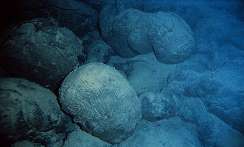
The internal architecture of the oceanic crust produced at ridges follows a layered structure that has been revealed both by seismic refraction studies and by direct observation of ophiolites — fragments of oceanic crust thrust onto land. From the surface downward, the canonical sequence comprises four units.9 The uppermost layer consists of pillow basalts — bulbous, rounded lava forms produced when magma erupts into cold seawater and quenches rapidly, forming glassy rinds that fracture and stack upon one another. Beneath the pillow basalts lies a sheeted dike complex, a dense array of vertical to sub-vertical tabular intrusions of basalt that represent the frozen conduits through which magma rose from below to feed the surface eruptions. Each dike intruded into the middle of the preceding one, producing a distinctive pattern in which one side of each dike is chilled against the next. Below the sheeted dikes lies a layer of coarse-grained gabbro, the slowly cooled plutonic equivalent of basalt that crystallised in a magma chamber beneath the ridge axis. At the base of the crustal section, a transition zone of cumulate ultramafic rocks gives way to the depleted mantle peridotite of the upper mantle, from which the magma was originally extracted by partial melting.9, 17
The magma chamber beneath a fast-spreading ridge has been imaged seismically as a thin lens of partially molten rock a few tens of metres thick and one to two kilometres wide, seated at a depth of roughly 1.5 kilometres below the seafloor.17 This lens sits atop a broader zone of crystal-rich mush extending deeper into the crust. At slow-spreading ridges, a persistent magma lens is often absent; magma supply is more episodic, and crustal accretion may occur through a combination of volcanic eruption and tectonic stretching of the lithosphere by normal faulting.8, 17
Fast-spreading and slow-spreading ridges
Not all mid-ocean ridges look alike. The morphology, magma supply, faulting style, and biological communities of a ridge segment depend critically on its spreading rate — the velocity at which the two flanking plates diverge. The full spreading rate (the sum of the velocities of the two plates moving apart) ranges from less than 20 millimetres per year at ultraslow ridges to more than 150 millimetres per year at the fastest segments of the East Pacific Rise.20, 24
The East Pacific Rise (EPR), the type example of a fast-spreading ridge, has a full rate of approximately 80 to 150 millimetres per year along most of its length. Its topographic profile is a broad, gentle dome rising only a few hundred metres above the surrounding abyssal plains, with a narrow axial summit trough rather than a deep rift valley.8 The robust and nearly continuous magma supply at fast ridges produces relatively uniform, layered crust and smooth, volcanically dominated terrain. Faulting is present but plays a secondary role in shaping the ridge morphology.
The Mid-Atlantic Ridge (MAR), by contrast, spreads at a full rate of only 20 to 30 millimetres per year and displays a dramatically different character. Its axis is defined by a prominent rift valley one to two kilometres deep and 15 to 30 kilometres wide, bounded by steep normal faults that accommodate tectonic extension in the absence of a continuous magma supply.8, 24 The crust produced at slow-spreading ridges is more heterogeneous, commonly thinner, and in some segments includes exposures of mantle peridotite on the seafloor where magma supply has been insufficient to generate a complete crustal section. Oceanic core complexes — dome-shaped exposures of deep crustal and upper-mantle rock exhumed along long-lived detachment faults — are a characteristic feature of slow and ultraslow ridges.
Characteristics of fast-spreading and slow-spreading ridges8, 20, 24
| Feature | Fast spreading (East Pacific Rise) | Slow spreading (Mid-Atlantic Ridge) |
|---|---|---|
| Full spreading rate | 80–150 mm/yr | 20–50 mm/yr |
| Axial morphology | Broad dome with narrow summit trough | Deep rift valley (1–2 km deep) |
| Magma supply | Robust and nearly continuous | Episodic, often insufficient |
| Axial magma lens | Persistent, seismically imaged | Rarely detected |
| Crustal thickness | ~6–7 km, relatively uniform | Variable, 3–8 km |
| Dominant accretion process | Volcanic (magmatic) | Mixed volcanic and tectonic |
| Faulting | Small-offset normal faults | Large-offset detachment faults |
| Segment length | Hundreds of kilometres | Tens of kilometres |
| Mantle exposure on seafloor | Rare | Common (oceanic core complexes) |
Intermediate-rate ridges, such as the Juan de Fuca Ridge and portions of the Southeast Indian Ridge spreading at 50 to 80 millimetres per year, display transitional characteristics and can alternate between rift-valley and axial-high morphologies along their length, sometimes within a single segment, depending on local variations in magma supply.24 The recognition that spreading rate exerts a first-order control on ridge morphology and crustal architecture was a major advance of the 1980s, established principally through the work of Ken Macdonald and colleagues.8, 24
Ridge push and its role in plate motion
Seafloor spreading does not merely create new crust; it also contributes a driving force to the motion of tectonic plates. The mid-ocean ridge stands topographically elevated above the surrounding ocean floor because the lithosphere at the ridge axis is young, hot, and therefore buoyant. As newly formed lithosphere moves away from the ridge, it cools by conduction into the overlying ocean, becomes denser, and subsides — a relationship first quantified by Barry Parsons and John Sclater, who showed that the depth of the ocean floor increases approximately as the square root of its age, consistent with the cooling of a thermal boundary layer.21
This systematic elevation difference between the ridge crest and the adjacent cooled lithosphere generates a horizontal gravitational body force — called ridge push — that acts on the plate and tends to drive it away from the ridge.16 Ridge push is not a force exerted by mantle upwelling pushing the plate apart from below, as is sometimes popularly misunderstood, but rather a gravitational sliding force arising from the lateral density contrast within the plate itself. The magnitude of ridge push increases with the age of the plate, because older, cooler lithosphere sits lower and the total potential energy difference with the ridge crest grows accordingly.
Quantitative analyses of the forces acting on tectonic plates indicate that ridge push contributes a significant but secondary fraction of the total driving force, accounting for perhaps 5 to 25 percent of the total. The dominant force is slab pull — the gravitational sinking of cold, dense oceanic lithosphere at subduction zones — which is estimated to account for the majority of plate-driving force.15, 16 The empirical evidence supports this apportionment: plates attached to large subducting slabs (such as the Pacific and Nazca plates) move substantially faster than plates without significant subduction zones (such as the African and Antarctic plates), a pattern consistent with slab pull as the primary driver and ridge push as a supporting contributor.15
Hydrothermal circulation and vent ecosystems
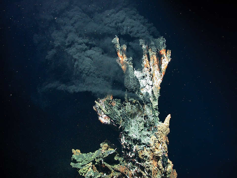
Among the most consequential discoveries in twentieth-century ocean science was the finding that mid-ocean ridges host vigorous hydrothermal circulation systems that profoundly influence ocean chemistry, heat transport, and biology. The existence of submarine hydrothermal vents was predicted on theoretical grounds — seawater must be heated as it percolates through the hot, fractured crust near the ridge axis — but the first direct observation came only in 1977, when scientists aboard the submersible Alvin discovered warm springs and dense biological communities on the Galapagos Rift at a depth of approximately 2,500 metres.13
The circulation system operates by a straightforward mechanism. Cold seawater (~2 °C) infiltrates the permeable upper crust through fractures and flows downward toward the heat source — the magma chamber or hot rock beneath the ridge axis. As the water descends, it is heated to temperatures exceeding 350 °C and undergoes dramatic chemical reactions with the surrounding basalt: it strips metals (iron, manganese, copper, zinc) from the rock, loses magnesium and sulfate, gains hydrogen sulfide, and becomes strongly acidic and reducing.18 This superheated, chemically transformed fluid is buoyant relative to the surrounding cold seawater and rises rapidly back to the seafloor, discharging through focused vents.
The most spectacular discharge features are black smokers, chimneys of precipitated metal sulfide minerals through which superheated fluid (up to 400 °C) jets into the near-freezing ambient seawater. The sudden temperature drop causes dissolved metals to precipitate instantly as fine-grained sulfide particles, producing the opaque black plume that gives these vents their name.14 Lower-temperature vents, called white smokers, emit fluid at 100 to 300 °C with a different chemistry and precipitate lighter-coloured minerals such as anhydrite and silica. Together, black and white smokers build complex chimney structures and massive sulfide deposits that are the modern analogues of the volcanogenic massive sulfide ore deposits found in ancient rocks on land.14
The biological communities at hydrothermal vents were among the most unexpected discoveries in the history of biology. Thriving in complete darkness at crushing pressures, these ecosystems are sustained not by photosynthesis but by chemosynthesis — the metabolic oxidation of hydrogen sulfide and other reduced chemicals by specialised bacteria and archaea, which fix carbon and form the base of a food chain that supports giant tube worms (Riftia pachyptila), clams, mussels, shrimp, and crabs.13, 19 The discovery that complex ecosystems could be entirely independent of solar energy fundamentally expanded scientific understanding of the possible habitats for life, both on Earth and on other planetary bodies. The chemosynthetic ecosystems at hydrothermal vents are now considered one of several candidate environments for the origin of life itself, and analogous systems are hypothesised to exist in the subsurface oceans of Saturn's moon Enceladus and Jupiter's moon Europa.23
The total hydrothermal heat flux at mid-ocean ridges is estimated at roughly 10 to 30 percent of the global oceanic heat flux, and the entire volume of the world's oceans is estimated to cycle through mid-ocean ridge hydrothermal systems every 10 to 20 million years — a rate sufficient to exert a significant influence on the chemical composition of seawater over geological time.18
Ophiolites: oceanic crust on land
Direct observation of the internal structure of oceanic crust generated at mid-ocean ridges is extraordinarily difficult because most of it lies beneath 2 to 5 kilometres of seawater and is buried under sediment. The most comprehensive windows into this crustal architecture are provided by ophiolites — structurally intact slices of oceanic crust and upper mantle that have been tectonically emplaced onto continental margins through a process called obduction, the reverse of the far more common subduction.10
The idealised ophiolite sequence, first codified by the 1972 Penrose Conference of the Geological Society of America, comprises, from top to bottom: deep-sea sediments, pillow basalts, a sheeted dike complex, layered gabbros, and ultramafic cumulates grading into upper-mantle peridotite (harzburgite and dunite). This sequence mirrors the layered structure of oceanic crust inferred from marine seismic studies and has been central to interpreting the seismically defined layers of the ocean floor in terms of actual rock types.9, 10
Two ophiolites have been especially important for understanding seafloor spreading. The Troodos ophiolite of Cyprus, one of the first to be recognised as a fragment of oceanic crust, preserves a well-exposed section through the upper crustal levels — pillow lavas, sheeted dikes, and upper gabbros — and was instrumental in establishing the sheeted dike complex as a diagnostic feature of oceanic crust formed by spreading. Vine and Moores showed in 1971 that the magnetic properties of the Troodos lavas matched those expected from seafloor spreading processes.11 The Samail (Oman) ophiolite, the largest and best-preserved ophiolite on Earth, exposes a nearly complete 15-kilometre-thick section from mantle peridotite through the entire crustal sequence. Its enormous lateral extent (approximately 500 by 100 kilometres) and exceptional exposure have made it the primary field laboratory for understanding the deep structure and magmatic plumbing of mid-ocean ridges.12
Not all ophiolites formed at typical mid-ocean ridges. Some represent crust generated in back-arc basins or at intermediate and slow-spreading ridges, and their internal structure can deviate significantly from the Penrose ideal — for instance, by lacking a well-developed sheeted dike complex or by including tectonic exposures of mantle peridotite similar to those observed at modern oceanic core complexes on slow ridges. These variations have enriched the ophiolite model by demonstrating that the architecture of oceanic crust is not uniform but depends on spreading rate and magma supply, consistent with the morphological differences observed between fast and slow ridges at the present day.10
The age of the ocean floor
The age distribution of the ocean floor provides one of the most direct and visually compelling confirmations of seafloor spreading.

Global compilations of oceanic crustal age, derived from magnetic anomaly identifications calibrated against the geomagnetic polarity timescale and supplemented by radiometric dating of drilled samples, show a striking pattern: the youngest crust lies along the mid-ocean ridge axes, and age increases systematically and symmetrically with distance from the ridges in both directions.7
The oldest oceanic crust on the present-day seafloor is found in the western Pacific, adjacent to the Mariana Trench and in the Pigafetta Basin, where magnetic anomalies and drill-core dating indicate ages of approximately 190 to 200 million years, corresponding to the early Jurassic period.7 No ocean floor older than this exists anywhere on Earth. The absence of Precambrian — or even Palaeozoic — oceanic crust, despite the fact that the Earth is 4.5 billion years old, is a direct consequence of the conveyor-belt cycle that Hess envisioned: oceanic crust is continuously created at ridges and continuously destroyed at subduction zones, with an average residence time on the surface of roughly 100 to 200 million years before recycling into the mantle.
The depth of the ocean floor correlates with its age through a well-established thermal relationship. As lithosphere moves away from the ridge and cools, it contracts and subsides. Parsons and Sclater showed in 1977 that ocean-floor depth increases approximately as the square root of age for young crust (less than about 80 million years), consistent with a simple half-space cooling model, but flattens for older crust at depths of roughly 5,500 to 6,000 metres, suggesting a finite plate thickness or additional heat input from below.21 This depth-age relationship has practical applications: it allows the age of any segment of ocean floor to be estimated from its depth alone, and it constrains models of mantle thermal structure.
The rate at which new oceanic crust is produced globally — the global spreading rate — is estimated at approximately 3.4 square kilometres of new seafloor per year, equivalent to the creation of an area roughly the size of a football pitch every few minutes.7 This rate has not been constant through geological time; plate reconstructions indicate that global spreading rates were higher during the Cretaceous period (roughly 120 to 80 million years ago), when a faster rate of ridge activity contributed to higher sea levels by displacing ocean water onto the continents, and lower during other intervals.7
Seafloor spreading in the plate tectonic framework
Seafloor spreading occupies a central position in the plate tectonic framework as the constructive half of the cycle that continuously renews the ocean floor. The divergent plate boundaries at which it occurs are complemented by the convergent boundaries — subduction zones — where oceanic lithosphere is consumed, completing the circuit that Hess first described as a conveyor belt. Together, these processes ensure that the oceanic crust is geologically ephemeral: it is perpetually young relative to the continental crust, which accumulates over billions of years because its buoyancy prevents it from being recycled into the mantle.1, 6
The confirmation of seafloor spreading in the 1960s did more than validate a single hypothesis. It provided the physical mechanism that united Wegener's continental drift with the emerging data on ocean-floor topography, earthquake distribution, and magnetic anomalies into a single, comprehensive theory of how the Earth's surface works.6 The Vine-Matthews-Morley magnetic anomaly test remains one of the most elegant examples of hypothesis testing in the geological sciences: a prediction derived from the theory of seafloor spreading was checked against an independently established geomagnetic timescale, and the quantitative agreement was precise enough to convert a hypothesis into an accepted mechanism within the span of a few years.2, 5 The ongoing operation of this process today, measurable by GPS to millimetre precision, confirms that the engine Hess envisioned continues to reshape the planet's surface in real time.20
References
Ophiolites and oceanic crust: new insights from field studies and the Ocean Drilling Program
A chemolithoautotrophic microbial community in the giant deep-sea hydrothermal vent environment