Overview
- The Khmer Empire, founded by Jayavarman II in 802 CE through the devaraja consecration on Phnom Kulen, grew into the largest pre-industrial urban complex in the world, with the Greater Angkor region sustaining an estimated 700,000 to 900,000 people at its thirteenth-century peak.
- Angkor's power rested on an extraordinary hydraulic infrastructure of barays, canals, and embankments spanning over 1,000 square kilometres, which captured monsoon rainfall for dry-season rice cultivation and shaped the physical layout of the city itself.
- LiDAR surveys conducted in 2012 and 2015 revealed that Angkor's formally planned urban landscape extended far beyond its visible temple complexes, while tree-ring climate reconstructions have linked the empire's fifteenth-century decline to prolonged droughts interspersed with destructive monsoon surges.
The Khmer Empire was the dominant political and cultural power of mainland Southeast Asia from the ninth through the fifteenth centuries. At its greatest territorial extent, the empire encompassed much of modern Cambodia, Thailand, Laos, and southern Vietnam, and its capital at Angkor grew into the largest pre-industrial urban complex yet documented, sprawling over more than 1,000 square kilometres of engineered landscape.8, 9 The empire's monumental temple architecture, above all Angkor Wat and the Bayon, ranks among the most ambitious construction programmes in human history, while its hydraulic infrastructure of massive reservoirs and canal networks sustained a population that recent modelling estimates at 700,000 to 900,000 people at the thirteenth-century peak.11 The Khmer story is one of innovative urbanism, religious transformation, and environmental vulnerability — a civilization whose rise and decline illuminate the relationship between complex societies and the landscapes they reshape.
Founding and the devaraja cult
The founding of the Khmer Empire is traditionally dated to 802 CE, when the ruler Jayavarman II conducted a consecration ceremony on the summit of Phnom Kulen (known in inscriptions as Mahendraparvata), a sandstone plateau rising north of the Tonle Sap basin. The primary textual evidence for this event comes from the Sdok Kak Thom inscription (K. 235), a stele erected in 1052 CE by descendants of the Brahman priest Hiranyadama, who reportedly officiated the ceremony. According to this inscription, the ritual established the devaraja cult, a Shaivite consecration that proclaimed Jayavarman II a chakravartin — a universal sovereign — and declared the Khmer lands independent of Javanese suzerainty.1, 2
Scholars have debated the precise meaning and political function of the devaraja institution. The French historian George Coedès interpreted it as a cult of divine kingship in which the ruler was identified with Shiva, legitimizing centralized authority through religious sanction.2 Hermann Kulke and later scholars have argued that the Sdok Kak Thom inscription, composed two centuries after the events it describes, may reflect the self-interested narrative of the priestly lineage rather than a straightforward historical account, and that the devaraja concept was more nuanced than a simple equation of king and god.1 Regardless of its exact theological content, the consecration at Phnom Kulen marked a decisive political consolidation. Jayavarman II unified disparate Khmer polities under a single royal authority, established a succession of capitals in the Angkor region, and set in motion the state-building process that would produce one of the medieval world's most powerful empires.2, 3
Angkor Wat and the reign of Suryavarman II
.jpg)
.jpg)
The most iconic achievement of the Khmer Empire is Angkor Wat, a temple complex constructed during the reign of Suryavarman II (r. 1113–1150 CE). Suryavarman II was unusual among Khmer rulers in his devotion to Vishnu rather than Shiva, and Angkor Wat was dedicated to that deity. The temple's westward orientation, atypical for Khmer religious architecture, has been interpreted by scholars as reflecting the association of Vishnu with the western cardinal direction, though the precise reasons remain debated.13
Angkor Wat covers approximately 162 hectares, including its surrounding moat, and its central tower rises to a height of roughly 65 metres above the ground. The temple's design follows a precise cosmological programme: the central quincunx of towers represents Mount Meru, the axis of the Hindu universe; the surrounding moat symbolizes the cosmic ocean; and the concentric galleries encode a complex calendrical and astronomical symbolism that Eleanor Mannikka has analysed in detail.13 The walls of the outer gallery carry nearly 1,000 square metres of bas-relief sculpture, including the celebrated depictions of the Churning of the Ocean of Milk, the Battle of Kurukshetra from the Mahabharata, and a historical procession showing Suryavarman II with his army and court.14
Suryavarman II was also an aggressive military campaigner who launched expeditions against the Dai Viet kingdom to the east and the Champa kingdom along the coast of central Vietnam. These campaigns extended Khmer influence but also placed enormous demands on the state's resources and military capacity.3, 15 After Suryavarman II's death around 1150 CE, the empire entered a period of instability that culminated in a devastating Cham naval invasion of Angkor in 1177, which temporarily sacked the capital.15
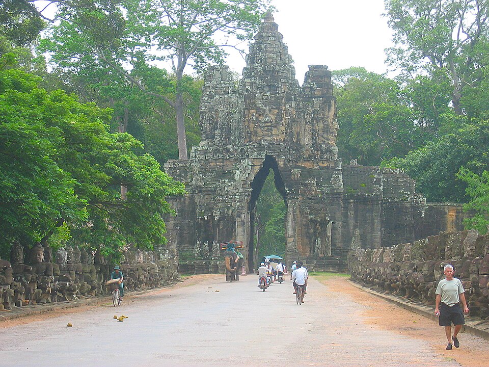
Jayavarman VII and the construction of Angkor Thom
The empire's recovery from the Cham invasion was led by Jayavarman VII (r. c. 1181–1218 CE), widely regarded as the most prolific builder in Khmer history.
.jpg)
Jayavarman VII expelled the Cham occupiers, reunified the empire, and launched a construction programme of unprecedented scale. His greatest achievement was the walled city of Angkor Thom, a roughly three-square-kilometre enclosure surrounded by an eight-metre-high laterite wall and a wide moat, entered through monumental gates flanked by rows of devas and asuras enacting the Churning of the Ocean of Milk.3, 4
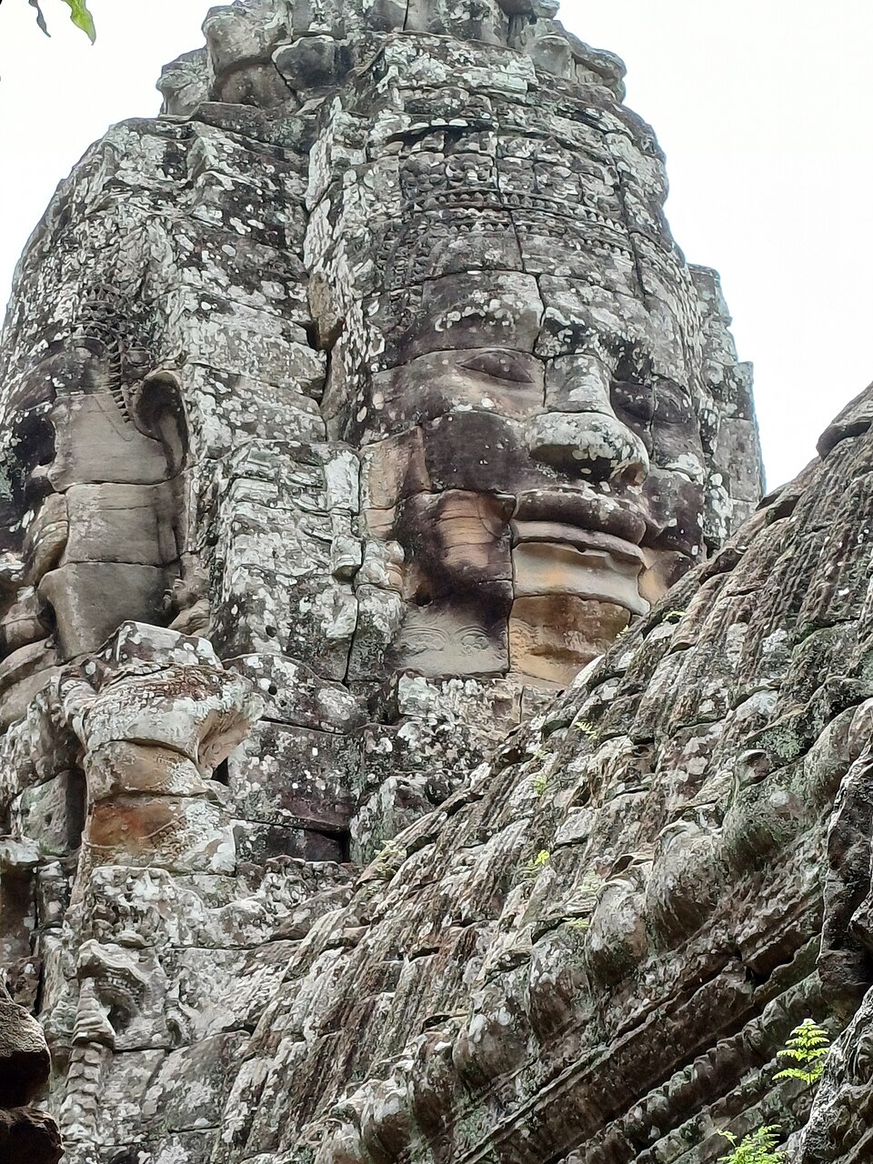
At the exact centre of Angkor Thom stands the Bayon, a temple whose approximately 200 massive stone faces, each bearing a serene and enigmatic smile, have become one of the most recognizable images of Southeast Asian art. The faces have been variously interpreted as representations of the bodhisattva Avalokiteshvara, of Jayavarman VII himself, or of a syncretic fusion of the two — reflecting the king's adoption of Mahayana Buddhism as the state religion.3, 14 This marked a profound religious shift: for nearly four centuries, the Khmer court had patronized Shaivite and Vaishnavite Hinduism, and Jayavarman VII's embrace of Mahayana Buddhism reoriented the ideological foundations of the state. The Bayon's bas-reliefs, unlike the mythological scenes of Angkor Wat, depict everyday life — market scenes, fishing, cockfights, and military campaigns — providing an invaluable record of Khmer society in the late twelfth century.14
Beyond temple construction, Jayavarman VII invested in infrastructure motivated by Buddhist ethics of compassion. Inscriptions record the establishment of 102 hospitals distributed across the empire and 121 rest houses along the major roads connecting provincial centres to the capital.3, 19 These programmes represented a deliberate projection of Buddhist ideals of care and relief from suffering onto the administrative apparatus of the state.
The hydraulic city
The material foundation of the Khmer Empire was water. The Angkor region sits on a gently sloping alluvial plain between the Kulen Hills to the north and the Tonle Sap lake to the south, receiving heavy monsoon rainfall from May through October followed by a prolonged dry season. The Khmer response to this seasonal regime was the construction of an immense hydraulic infrastructure — what Roland Fletcher has termed a hydraulic city — comprising massive reservoirs (barays), distribution canals, embankments, and rice-field networks that captured, stored, and directed monsoon water for dry-season agriculture.18, 5
The largest of these reservoirs, the West Baray, measures approximately 8 kilometres by 2.1 kilometres and held an estimated 48 million cubic metres of water. The East Baray, slightly smaller, stored roughly 37 million cubic metres. Two additional barays — the Indratataka and the Jayatataka (associated with the Preah Khan temple) — contributed further capacity.5, 6 Together with a network of canals extending across more than 1,000 square kilometres, these reservoirs formed an integrated system that Fletcher and colleagues mapped through a combination of aerial photography, satellite imagery, and ground survey.5
Major barays of the Angkor hydraulic system5, 6
| Baray | Approximate dimensions | Estimated volume | Period of construction |
|---|---|---|---|
| Indratataka | 3.8 km × 0.8 km | ~7.5 million m³ | Late 9th century |
| East Baray (Yashodharatataka) | 7.5 km × 1.8 km | ~37 million m³ | Late 9th–early 10th century |
| West Baray | 8.0 km × 2.1 km | ~48 million m³ | 11th century |
| Jayatataka (Preah Khan Baray) | 3.7 km × 0.9 km | ~8.7 million m³ | Late 12th century |
Sediment cores from the West Baray have revealed a complex depositional history, including evidence of periodic silting and episodes of reduced water levels, suggesting that maintaining the hydraulic system required constant labour and engineering intervention.7 The barays were not merely utilitarian reservoirs; they also served cosmological functions, representing the oceans surrounding Mount Meru in the Hindu-Buddhist cosmological model, and the temples placed on islands at their centres — the West Mebon and East Mebon — symbolized the sacred mountain itself.3, 18
Population and agricultural surplus
The hydraulic infrastructure of Angkor enabled the intensive rice cultivation that sustained one of the largest urban populations of the pre-industrial world. Recent demographic modelling by Damian Evans, combining LiDAR-derived settlement data, archaeological excavation results, and radiocarbon chronologies, estimates that the Greater Angkor region supported approximately 700,000 to 900,000 inhabitants at its thirteenth-century apogee.11 This figure makes Angkor broadly comparable in population to ancient Rome at its first-century peak and far larger than any contemporary European city of the medieval period.
Unlike the densely nucleated cities of the Mediterranean and the Middle East, Angkor was a dispersed, agrarian urban landscape in which residential areas, rice fields, water features, and temples were interspersed across a vast territory. This settlement pattern, visible in LiDAR data as a regular grid of mounded residential plots alternating with excavated ponds and field systems, reflects a mode of urbanism in which food production was embedded within the city rather than relegated to a surrounding hinterland.8, 11 The system was productive enough to generate the agricultural surplus necessary to support the monumental construction programmes, the standing armies, and the religious and administrative elites that characterized the Khmer state.3, 4
Religious transitions
The religious history of the Khmer Empire traces a progression from Shaivite Hinduism through Vaishnavism and Mahayana Buddhism to the Theravada Buddhism that prevails in Cambodia today. The earliest Khmer rulers, including Jayavarman II, patronized Shiva worship and established royal lingas as symbols of divine kingship.1, 2 Suryavarman II redirected royal devotion toward Vishnu, as embodied in Angkor Wat, while maintaining the broader Hindu ritual framework of the court.13 Jayavarman VII's adoption of Mahayana Buddhism in the late twelfth century represented a more dramatic rupture, reorienting state ideology around the bodhisattva ideal of compassion and the figure of Avalokiteshvara.3, 14
The final major religious transition began in the thirteenth century with the gradual spread of Theravada Buddhism, transmitted by monks with connections to the Sinhalese monastic tradition of Sri Lanka and the Mon kingdoms of mainland Southeast Asia. Zhou Daguan, the Chinese envoy who resided at Angkor from 1296 to 1297, recorded the visible presence of Theravada monks alongside the Brahmanic and Mahayana institutions of the court, indicating that the transition was well underway during this period.12 Theravada Buddhism, with its emphasis on personal piety, monastic simplicity, and the accessibility of the dharma to laypeople, gradually displaced the elaborate court-centred rituals of Hinduism and Mahayana Buddhism. By the fourteenth and fifteenth centuries, Theravada had become the dominant religion of the Khmer population.15, 20 Some scholars have argued that this transformation weakened the ideological underpinnings of divine kingship that had sustained centralized Khmer authority, though the relationship between religious change and political decline remains debated.15, 16
Trade networks
The Khmer Empire was enmeshed in the maritime and overland trade networks that linked ancient India, ancient China, and the island kingdoms of Southeast Asia. Indian cultural influence was foundational: Sanskrit served as the language of court inscriptions, Hindu and Buddhist religious forms shaped Khmer architecture and statecraft, and Indian concepts of kingship informed the devaraja institution.2, 20 Chinese trade connections were equally important in material terms. Zhou Daguan's account of his 1296–1297 sojourn at Angkor documents a thriving commercial quarter inhabited by Chinese merchants and describes the exchange of Chinese manufactured goods — silk, ceramics, lacquerware — for Khmer exports including kingfisher feathers, cardamom, elephant ivory, and rhinoceros horn.12
The Tonle Sap lake and its connected river system provided the Khmer Empire with a navigable waterway linking the interior capital to the Mekong Delta and, from there, to the South China Sea. Archaeological evidence of Chinese stoneware and celadon ceramics at Angkor and at provincial Khmer sites confirms the extent of this commercial exchange.3, 15 The empire also maintained diplomatic and tributary relationships with successive Chinese dynasties, as recorded in Chinese histories that refer to the Khmer realm as Zhenla and later as Cambodia.12, 15
Decline and abandonment of Angkor
The decline of the Khmer Empire and the abandonment of Angkor as the political capital in the fifteenth century was a protracted process driven by multiple interacting factors rather than a single catastrophic event. The traditional narrative, emphasizing Thai (Ayutthayan) military pressure culminating in the sack of Angkor in 1431, captures only one dimension of a more complex transformation.15
A landmark study by Brendan Buckley and colleagues, published in 2010, used a 759-year tree-ring chronology from Vietnamese cypress trees to reconstruct monsoon variability in mainland Southeast Asia. The reconstruction revealed that the fourteenth and fifteenth centuries were marked by two prolonged mega-droughts, each lasting decades, interspersed with episodes of abnormally intense monsoon rainfall. The driest consecutive years in the entire record — 1402 and 1403 — fell approximately three decades before the traditional date of Angkor's abandonment, and several of the wettest years in the record also occurred during this period of generally weakened monsoon strength.10 The combination of protracted drought, which would have reduced the water stored in the barays and compromised rice yields, and sudden intense monsoons, which could have damaged the canal and embankment infrastructure, placed the hydraulic system under stresses it was not designed to withstand.10, 18
More recent archaeological work by Dan Penny and colleagues has refined the picture of Angkor's decline, demonstrating that the city did not collapse suddenly but rather experienced a gradual process of demographic dispersal and infrastructural abandonment over more than a century. Sediment analysis from Angkor's canal system suggests that parts of the hydraulic network had already fallen out of use by the late fourteenth century, well before the Ayutthayan attacks.17 The relocation of the Khmer capital southward to the Phnom Penh region, closer to the maritime trade routes of the Mekong Delta, may also reflect a deliberate strategic reorientation toward the expanding international commerce of the South China Sea, rather than a simple retreat from military defeat.15, 16
LiDAR and the rediscovery of Greater Angkor
The application of airborne laser scanning (LiDAR) technology to the Angkor landscape has fundamentally transformed scholarly understanding of the Khmer Empire's urban extent and organization. In 2012, the Cambodian Archaeological Lidar Initiative (CALI), led by Damian Evans, conducted a helicopter-mounted LiDAR survey covering 370 square kilometres of forested terrain around Angkor and the nearby sites of Phnom Kulen and Koh Ker. By penetrating the dense tropical canopy and generating high-resolution digital elevation models of the ground surface, the survey revealed a formally planned urban landscape extending far beyond the visible stone temples.8
The 2012 survey confirmed that Angkor Thom's gridded city-block structure extended well beyond its walls, encompassing more than 35 square kilometres of formally planned urban space including the Angkor Wat enclosure. On Phnom Kulen, the LiDAR data revealed an entire previously undocumented ninth-century city — identifiable with Mahendraparvata, the capital established by Jayavarman II — complete with a rectilinear grid of roads, canals, ponds, and mounded occupation sites hidden beneath the forest.8
A second, much larger LiDAR campaign in 2015 surveyed approximately 1,910 square kilometres, revealing additional temple complexes, urban grids, and hydraulic features at sites across the Khmer heartland. The data demonstrated that formally planned, low-density urbanism and sophisticated water management infrastructure emerged as early as the fifth and sixth centuries, centuries before the conventional founding date of the empire, suggesting deep indigenous roots for the urban traditions later associated with Angkor.9 Together, these surveys have established that Angkor was not a collection of isolated temple complexes set in forest, as early European visitors assumed, but a continuously engineered landscape of monumental density — the largest pre-industrial settlement complex yet documented anywhere in the world.8, 9
Legacy of the Khmer civilization
The Khmer Empire's material and cultural legacy extends far beyond the ruins of Angkor. The temple of Angkor Wat has served as a symbol of Cambodian national identity since at least the sixteenth century, when Theravada Buddhist monks maintained it as a pilgrimage site, and it appears on every Cambodian national flag since the country's independence.21 UNESCO inscribed the Angkor Archaeological Park as a World Heritage Site in 1992, recognizing it as one of the most important archaeological sites in Southeast Asia.21
The Khmer achievement in hydraulic engineering, monumental architecture, and large-scale urban planning has also reshaped broader scholarly debates about the nature of pre-industrial urbanism. The Angkor evidence has challenged assumptions that complex urbanism required Mediterranean-style nucleated settlement, demonstrating instead that dispersed, agrarian forms of urban life could sustain populations and construction programmes rivalling those of the ancient Western world.18, 11 The ongoing LiDAR-driven discoveries continue to reveal new dimensions of this civilization, and the Khmer Empire's story — of ingenuity, ambition, and ultimate vulnerability to environmental change — remains one of the most instructive case studies in the archaeology of complex societies.9, 10, 17
References
Airborne laser scanning as a method for exploring long-term socio-ecological dynamics in Cambodia
Diachronic modeling of the population within the medieval Greater Angkor Region settlement complex
The Khmer Empire: The History of the Cambodian Kingdom Through the Rise and Fall of Angkor