Overview
- Magnetic anomaly stripes on the ocean floor, symmetric about mid-ocean ridges, record millions of years of geomagnetic reversals frozen into cooling basalt, providing a continuous tape-recorder of plate motion that independently confirms deep time.
- Radiometric dating of ocean-floor drill cores, GPS-measured plate velocities, and hotspot tracks such as the Hawaiian-Emperor seamount chain all converge on spreading rates of 2 to 15 centimetres per year, rates that require hundreds of millions of years to produce the observed width of ocean basins.
- The oldest oceanic crust on Earth is approximately 200 million years old because subduction continuously recycles the seafloor back into the mantle, meaning the ocean floor is a self-erasing record whose very absence of ancient crust demands a planet far older than the surviving oceanic lithosphere.
The ocean floor is a magnetic tape recorder. As molten basalt erupts at mid-ocean ridges and cools through its Curie temperature, iron-bearing minerals in the rock lock in the orientation of Earth's magnetic field at that moment. Because the geomagnetic field has reversed its polarity hundreds of times over the past several hundred million years, the result is a pattern of alternating normally and reversely magnetised stripes running parallel to the ridge axis, symmetric on both sides. The width of each stripe, combined with independent knowledge of when each reversal occurred, yields a direct measurement of the rate at which the seafloor has been spreading apart.1, 2 These spreading rates, confirmed by radiometric dating of ocean-floor drill cores, GPS-measured plate velocities, and the age progressions of hotspot volcanic chains, all converge on values of a few centimetres per year. Integrated over the observed widths of the ocean basins, such rates require hundreds of millions of years of continuous plate motion, providing one of the most robust independent confirmations that the Earth is billions of years old.7, 10
Discovery of seafloor spreading
The concept of seafloor spreading was first articulated by Harry Hess in 1962, who proposed that the ocean floor is not permanent but is continuously created at mid-ocean ridges and destroyed at deep-sea trenches. Hess envisioned mantle convection cells carrying material upward beneath the ridges, where it solidified into new oceanic crust and then moved laterally away from the ridge axis like a conveyor belt, eventually descending back into the mantle at subduction zones.3 Hess cautiously called his paper an "essay in geopoetry," recognising that direct evidence for the mechanism was still lacking.
That evidence arrived the following year. In 1963, Frederick Vine and Drummond Matthews at Cambridge published a short paper in Nature proposing that the pattern of magnetic anomalies observed over the Carlsberg Ridge in the Indian Ocean could be explained if new ocean crust recorded the ambient geomagnetic field polarity as it formed, and if the field had reversed repeatedly over time. As the seafloor spread away from the ridge, it would carry these magnetised bands with it, producing the observed pattern of alternating positive and negative magnetic anomalies symmetric about the ridge crest.1 Lawrence Morley in Canada independently arrived at the same hypothesis at essentially the same time, though his manuscript was rejected by two journals before Vine and Matthews published; the idea is now known as the Vine-Matthews-Morley hypothesis.4
The hypothesis was dramatically confirmed in 1966 when Vine published a comprehensive analysis of magnetic anomaly profiles from the East Pacific Rise, the Juan de Fuca Ridge, and the Reykjanes Ridge south of Iceland. In every case, the pattern of anomalies matched the independently established geomagnetic polarity reversal timescale with striking precision, and the anomalies were mirror-symmetric about the ridge axis.2 This correspondence between the magnetic stripes on the ocean floor and the known sequence of geomagnetic reversals constituted one of the key confirmations of plate tectonics and transformed the Earth sciences.
The magnetic anomaly record
The geomagnetic polarity timescale (GPTS) is the calibrated sequence of normal and reversed polarity intervals that the Earth's magnetic field has undergone throughout geological time. The timescale was initially established for the past few million years by radiometrically dating volcanic rocks on land whose magnetic polarity had been measured, a programme pioneered by Allan Cox, Richard Doell, and Brent Dalrymple in the early 1960s.5 Their work demonstrated that the field had reversed at least four times in the past 3.6 million years, defining the now-familiar sequence of polarity epochs (Brunhes normal, Matuyama reversed, Gauss normal, Gilbert reversed) and shorter polarity events within them.
The marine magnetic anomaly record extended this timescale enormously. Because the ocean floor preserves a continuous record of geomagnetic polarity from the time of its creation at a mid-ocean ridge, and because the width of each anomaly stripe is proportional to the duration of the corresponding polarity interval multiplied by the spreading rate, the seafloor magnetic record can be "read" outward from a ridge crest like a barcode. Steven Cande and Dennis Kent produced the most widely used Cenozoic and Late Cretaceous geomagnetic polarity timescale by calibrating the marine magnetic anomaly sequence against a small number of radiometrically dated tie-points, yielding a detailed record of more than 180 million years of geomagnetic reversals.6, 20
The magnetic anomaly record reveals that the geomagnetic field has reversed its polarity hundreds of times since the mid-Jurassic, at irregular intervals ranging from tens of thousands to tens of millions of years. During the Cretaceous Normal Superchron, the field maintained a single polarity for approximately 38 million years (roughly 121 to 83 million years ago), leaving a conspicuous gap in the reversal record and a correspondingly wide, uniformly magnetised band of ocean crust.6, 20 The very existence of this record, stretching symmetrically across thousands of kilometres of ocean floor on either side of active ridges, requires continuous seafloor spreading over immense spans of geological time.
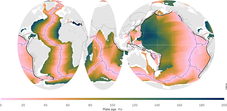
Ages of the ocean floor
A global compilation of ocean-floor ages, constructed from the marine magnetic anomaly record and calibrated against radiometric dates from drill cores, reveals a systematic pattern: oceanic crust is youngest at the mid-ocean ridges and progressively older with increasing distance from the ridge axis, reaching a maximum age of approximately 200 million years (early Jurassic) in the western Pacific and northwestern Atlantic.10, 19 No oceanic crust older than about 280 million years has been found anywhere on Earth, and the vast majority is younger than 200 million years.
The absence of ancient oceanic crust is itself a powerful constraint. Continental crust preserves rocks as old as 4.0 billion years, yet the ocean floor, which covers more than 60 percent of the planet's surface, retains nothing older than roughly 200 million years. The explanation is subduction: oceanic lithosphere is continuously created at ridges and destroyed at trenches, so the ocean floor is a self-erasing record with a characteristic residence time of 100 to 200 million years before recycling into the mantle.10 The oldest surviving oceanic crust lies in the Pigafetta and East Mariana basins of the western Pacific, where radiometric dating of basalts recovered by ocean drilling has yielded ages of approximately 167 to 170 million years, with some estimates extending to nearly 200 million years for the oldest seafloor in the adjacent Nauru Basin.17
The global age distribution of the ocean floor is not uniform. The Atlantic Ocean, which is still widening, is floored by crust that is oldest along its margins and youngest along the Mid-Atlantic Ridge. The Pacific, by contrast, is shrinking as subduction consumes its margins, and its oldest crust survives only in the remote western basins farthest from the encircling trenches. The Indian Ocean displays an intermediate pattern, with complex age distributions reflecting the breakup of Gondwana and the northward migration of India.10, 19
Age of oldest oceanic crust by ocean basin10, 17, 19
| Ocean basin | Location of oldest crust | Approximate age (Ma) |
|---|---|---|
| Western Pacific | Pigafetta & East Mariana basins | ~167–200 |
| Northwestern Atlantic | Off eastern North America | ~180 |
| Eastern Mediterranean | Herodotus Basin | ~270–340 (disputed) |
| Indian Ocean | Off northwestern Australia | ~155–160 |
| South Atlantic | Off southern Africa & South America | ~130–140 |
Drill core confirmation
The magnetic anomaly interpretation of ocean-floor ages received its most direct confirmation from the Deep Sea Drilling Project (DSDP), which began in 1968 aboard the drilling vessel Glomar Challenger. On its third leg in 1969, the DSDP drilled a series of holes across the South Atlantic at progressively greater distances from the Mid-Atlantic Ridge. The basal sediments resting directly on the basaltic basement at each site contained microfossils whose biostratigraphic ages increased systematically with distance from the ridge, exactly as predicted by the seafloor spreading hypothesis.11 This result was hailed as one of the most important confirmations of the plate tectonic paradigm.
Subsequent decades of ocean drilling through the DSDP (1968–1983), the Ocean Drilling Program (ODP, 1985–2003), and the Integrated Ocean Drilling Program and its successor the International Ocean Discovery Program (IODP, 2003–present) have drilled thousands of holes into the ocean floor worldwide. Radiometric dating of basaltic basement samples recovered from these cores, using potassium-argon, argon-argon, and uranium-lead methods, has consistently confirmed the age predictions derived from the marine magnetic anomaly timescale.18 Where discrepancies exist, they are typically small and attributable to post-emplacement alteration of the basalt or to complexities in the local spreading history. The overall agreement between magnetically inferred ages and radiometrically measured ages across all ocean basins represents a powerful cross-validation of both the spreading model and the radiometric dating methods themselves.
The drill cores have also revealed the detailed stratigraphy of the sedimentary column overlying the basaltic basement. The thickness of this sediment blanket increases with distance from the ridge, consistent with the longer time available for pelagic sediment to accumulate on older crust. The oldest sediments at each site, resting directly on basement, match the magnetically predicted age of the underlying crust, providing yet another independent check.11, 18
GPS-measured plate velocities
Since the early 1990s, the Global Positioning System and other space-geodetic techniques (very long baseline interferometry, satellite laser ranging) have enabled direct measurement of the velocities at which tectonic plates move relative to one another. These measurements provide an entirely independent check on the spreading rates inferred from the magnetic anomaly record and geological plate motion models.9
Geological plate motion models such as NUVEL-1 and its successor MORVEL are derived from the magnetic anomaly record and transform fault azimuths, averaged over the past 0.78 to 3.16 million years.8, 7 GPS measurements, by contrast, capture plate motion over timescales of years to decades. The remarkable finding is that the two sets of velocities agree to within a few millimetres per year for most plate pairs. The Pacific Plate moves northwestward relative to the North American Plate at approximately 50 millimetres per year as measured by GPS, consistent with the geologically averaged rate. The Nazca Plate converges with South America at roughly 60 to 70 millimetres per year by both methods. The North Atlantic opens at approximately 23 to 25 millimetres per year, a rate confirmed by GPS stations on either side of the Mid-Atlantic Ridge.7, 9
This agreement between geological rates averaged over millions of years and instrumentally measured rates over mere decades demonstrates that plate motions are remarkably steady over time. It also means that the spreading rates used to interpret the magnetic anomaly record are not hypothetical extrapolations but directly measured velocities applied uniformly over geological history. If the Mid-Atlantic Ridge has been spreading at approximately 2.5 centimetres per year, as both the magnetic record and GPS confirm, then the roughly 6,000-kilometre width of the Atlantic Ocean basin requires approximately 180 million years to open, consistent with the Jurassic breakup of Pangaea documented in the geological record.7, 10
Present-day spreading rates at major mid-ocean ridges7, 9, 19
Hotspot tracks and the Hawaiian-Emperor chain
Hotspot volcanic chains provide a third independent method for measuring plate velocities and confirming the timescale of seafloor spreading. The concept, developed by J. Tuzo Wilson and W. Jason Morgan in the 1960s and 1970s, holds that some volcanic centres are fed by mantle plumes rising from deep within the Earth. As a tectonic plate moves over a relatively stationary plume, it produces a chain of volcanoes whose ages increase progressively in the direction of plate motion.13, 19
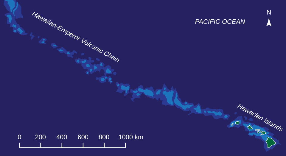
The Hawaiian-Emperor seamount chain is the most thoroughly studied example. The chain extends more than 6,000 kilometres across the Pacific, from the active volcanoes of the Big Island of Hawaii in the southeast to the 81-million-year-old Detroit Seamount near the Aleutian Trench in the northwest.15 Radiometric dating of samples dredged and drilled from seamounts along the chain reveals a remarkably linear age-distance relationship: each seamount is older than the one to its southeast by an amount consistent with a plate velocity of approximately 70 to 100 millimetres per year (for the Emperor segment) and approximately 70 millimetres per year (for the Hawaiian segment).14, 15
The prominent bend in the Hawaiian-Emperor chain, located at approximately 30 degrees north latitude, has been radiometrically dated to approximately 47 to 50 million years ago. This bend was long interpreted as recording a major change in Pacific Plate motion direction, though more recent work suggests that southward drift of the Hawaiian plume itself may also have contributed.14, 16 Regardless of the cause of the bend, the radiometric ages along the chain establish beyond question that the Pacific Plate has been moving continuously for at least 80 million years, and that the velocity measured by this method is consistent with the velocity derived independently from magnetic anomalies and GPS.14, 15, 16
Other hotspot tracks around the world reinforce the same conclusion. The New England Seamount chain in the Atlantic records the passage of the North American Plate over a mantle plume from approximately 103 to 82 million years ago.12 The Walvis Ridge and Rio Grande Rise in the South Atlantic trace the separation of South America and Africa over the Tristan da Cunha hotspot. The Ninetyeast Ridge in the Indian Ocean marks the northward passage of the Indian Plate over the Kerguelen hotspot for more than 80 million years. In each case, the radiometrically dated age progressions along these features yield plate velocities consistent with those derived from the magnetic anomaly record.13, 19
Variation in spreading rates
Seafloor spreading rates are not constant across all ridges or through all of geological time.

Present-day full spreading rates (the total rate of separation between two plates) range from approximately 12 millimetres per year at the ultraslow Gakkel Ridge beneath the Arctic Ocean to approximately 150 millimetres per year at the fastest segments of the East Pacific Rise near Easter Island.7, 19 Ridges are conventionally classified by their spreading rate: ultraslow (less than 20 mm/yr full rate), slow (20 to 55 mm/yr), intermediate (55 to 75 mm/yr), fast (75 to 130 mm/yr), and superfast (greater than 130 mm/yr). The Mid-Atlantic Ridge is a slow-spreading ridge, while most of the East Pacific Rise is fast to superfast.7
Spreading rate exerts a first-order control on ridge morphology. Slow-spreading ridges like the Mid-Atlantic Ridge have a pronounced axial rift valley, rugged topography, and widely spaced volcanic eruptions, because the magma supply is low relative to the rate of tectonic extension. Fast-spreading ridges like the East Pacific Rise have a smooth, elevated axial high with no rift valley, because a robust magma supply fills in tectonic gaps nearly as fast as they open.7, 19
The magnetic anomaly record also reveals that spreading rates have changed over geological time. The global mean half-spreading rate appears to have been somewhat higher during the Cretaceous (roughly 145 to 66 million years ago) than during the Cenozoic, with consequences for sea level, ocean chemistry, and global climate. Faster spreading produces a hotter, more buoyant mid-ocean ridge system that displaces seawater and raises global sea level, which may help explain the unusually high sea levels of the Cretaceous period.6, 10 Despite these temporal variations, the rates have always remained on the order of centimetres per year, never approaching the dramatically different values that would be required to compress the observed width of the ocean basins into a timescale shorter than hundreds of millions of years.
Convergence of independent evidence
The power of the seafloor spreading rate evidence for deep time lies in the convergence of entirely independent methods. The marine magnetic anomaly record provides spreading rates averaged over millions of years, calibrated by radiometric dating of land-based volcanic rocks and ocean-floor drill cores.1, 2, 6 GPS and other space-geodetic techniques measure the same plate velocities directly over timescales of years to decades.9 Hotspot volcanic chains record plate motion over tens of millions of years through the radiometric ages of individual seamounts.13, 14 The DSDP, ODP, and IODP drill cores confirm that the age of oceanic basement increases linearly with distance from the ridge.11, 18 And the global age map of the ocean floor, derived from all of these sources, shows a coherent pattern fully consistent with continuous spreading over the past 200 million years.10, 19
These independent lines of evidence do not merely suggest deep time; they require it. The Atlantic Ocean is approximately 6,000 kilometres wide, and the Mid-Atlantic Ridge is spreading at roughly 25 millimetres per year. Simple arithmetic yields an age of approximately 180 million years for the oldest Atlantic crust, in agreement with the Jurassic ages measured directly from drill cores and magnetic anomalies. The Pacific Ocean, spreading at up to 150 millimetres per year but simultaneously being consumed by subduction, maintains its observed basin dimensions only through a dynamic balance that has been operating for hundreds of millions of years. The Hawaiian-Emperor chain alone documents 80 million years of continuous Pacific Plate motion at rates consistent with the magnetic and geodetic evidence.7, 14, 15
No alternative timescale can accommodate these observations. The magnetic anomaly stripes are real physical features measurable with shipborne and airborne magnetometers. The radiometric ages of drill-core basalts are determined by the decay of radioactive isotopes at rates that are constant, well-measured, and confirmed by multiple independent decay systems. The GPS velocities are measured to sub-millimetre precision using satellites and ground stations. The hotspot age progressions are confirmed by multiple radiometric methods on samples collected from dozens of seamounts. Each of these methods operates on different physical principles, yet they all converge on the same spreading rates and the same timescales, demanding an Earth that is billions of years old and ocean basins that have been opening and closing over hundreds of millions of years.7, 9, 10, 19
References
Age progressive volcanism in the New England Seamounts and the opening of the central Atlantic Ocean