Overview
- Subduction is the process by which dense oceanic lithosphere descends into the mantle at convergent plate boundaries, and slab pull at these zones constitutes the dominant driving force of plate tectonics.
- The descending slab generates a characteristic inclined plane of seismicity called a Wadati-Benioff zone, produces arc magmatism through flux melting of the mantle wedge, and creates the trench-arc-back-arc geometry that defines convergent margins worldwide.
- Subduction zones recycle water, carbon, and sediment into the deep mantle over geological time, regulate Earth's volatile budget and long-term climate, and generate the planet's most powerful earthquakes, including the 2004 Sumatra and 2011 Tohoku megathrust events.
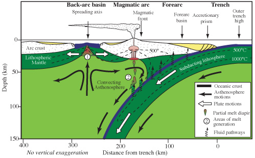
Subduction is the process by which oceanic lithosphere descends into Earth's mantle at convergent plate boundaries. It is the dominant mechanism by which the planet's surface is recycled, the primary driver of plate motion, and the source of the most powerful earthquakes and explosive volcanic eruptions on Earth. Where one tectonic plate plunges beneath another, a characteristic suite of geological features develops: a deep oceanic trench at the surface, an inclined zone of earthquakes tracing the path of the descending slab, a chain of volcanoes in the overriding plate fed by magma generated through the release of water from the sinking slab, and in many cases an extensional basin behind the volcanic arc.1, 3 Subduction zones are the destructive counterpart to the constructive mid-ocean ridges where new lithosphere is created; together, these two processes constitute the conveyor-belt cycle that continuously renews the ocean floor while preserving the ancient continental crust.
Definition and basic mechanics
Oceanic lithosphere forms at mid-ocean ridges, where hot mantle material rises and solidifies into new crust. As this lithosphere moves away from the ridge over millions of years, it cools, thickens, and becomes progressively denser than the underlying asthenosphere. When its density exceeds that of the asthenosphere, the plate becomes gravitationally unstable and, upon reaching a convergent boundary, bends downward and sinks into the mantle in the process called subduction.1 The subducting plate descends along an inclined plane, dragging the rest of the plate behind it through a gravitational body force known as slab pull.
Quantitative analyses of the forces acting on tectonic plates have established that slab pull is the dominant driver of plate motion, substantially exceeding the contribution of ridge push, the gravitational sliding force exerted by the elevated topography of mid-ocean ridges.1, 2 The empirical evidence is striking: plates attached to large, actively subducting slabs move significantly faster than plates that lack subduction zones. The Pacific Plate, the Nazca Plate, and the Cocos Plate, all of which are being consumed at major subduction zones, travel at velocities of 5 to 10 centimetres per year, whereas plates without extensive subduction, such as the African and Antarctic plates, move at only 1 to 3 centimetres per year.2, 22 This velocity correlation provides direct support for the primacy of slab pull as the engine of global plate tectonics.
The geometry of a subduction zone is defined by the angle at which the descending slab dips into the mantle, the rate of convergence between the two plates, and the age and thermal state of the subducting lithosphere. Old, cold oceanic crust subducts more readily because it is denser, and subduction zones consuming very old lithosphere tend to exhibit steeper dip angles. Where young, warm, and buoyant lithosphere is subducted, the dip may be shallow, with profound consequences for the tectonics and volcanism of the overriding plate.1, 13
Wadati-Benioff seismic zones
The existence of subduction zones was first inferred from the distribution of earthquakes. In the 1930s, the Japanese seismologist Kiyoo Wadati noticed that earthquakes beneath the Japanese islands did not occur at random depths but instead defined an inclined plane dipping from the oceanic trench toward the continental interior, with progressively deeper events occurring farther inland.5 In the 1950s and 1960s, the American seismologist Hugo Benioff independently identified the same pattern at subduction zones around the Pacific rim. These inclined seismic planes, now called Wadati-Benioff zones, trace the path of the cold, brittle subducting slab as it descends through the hotter, more ductile mantle.
Wadati-Benioff zones typically extend from the shallow trench region, where thrust-faulting earthquakes dominate, to depths of 300 to 660 kilometres, depending on the age and thermal state of the subducting slab.3, 4 Shallow earthquakes (less than 70 kilometres depth) along the subduction interface are generated by the frictional coupling between the descending plate and the overriding plate, and these include the great megathrust earthquakes discussed below. Intermediate-depth earthquakes (70 to 300 kilometres) are thought to result from dehydration reactions within the slab, in which the breakdown of hydrous minerals such as serpentine and lawsonite generates localized fluid overpressures that reduce the effective stress on potential fault planes and trigger brittle failure.4 Deep earthquakes (below 300 kilometres), which occur in a regime where conventional brittle fracture should be suppressed by enormous confining pressures, may be caused by transformational faulting associated with the phase change of olivine to its denser spinel polymorph (wadsleyite and ringwoodite) within the cold slab interior.4
The deepest reliably located earthquakes occur at approximately 660 to 680 kilometres, corresponding to the boundary between the upper and lower mantle and the dissociative phase transition from ringwoodite to bridgmanite and ferropericlase. Below this depth, the slab apparently deforms aseismically as it enters the lower mantle, and no earthquakes have been recorded.4, 12 The sharpness of this seismic cutoff at 660 kilometres was one of the earliest lines of evidence for the importance of the mantle transition zone in controlling slab dynamics.
Trench morphology and forearc structure
The surface expression of a subduction zone is the oceanic trench, a narrow, elongated depression in the seafloor that marks where the subducting plate bends downward and begins its descent. Trenches are the deepest features on Earth's surface. The Mariana Trench in the western Pacific reaches a maximum surveyed depth of approximately 10,994 metres at the Challenger Deep, more than 2 kilometres deeper than Mount Everest is tall.6 Other exceptionally deep trenches include the Tonga Trench (10,882 metres), the Kuril-Kamchatka Trench (approximately 10,500 metres), and the Philippine Trench (approximately 10,540 metres). Trench depth is controlled primarily by the age and density of the subducting plate and by the rate of sediment supply: trenches receiving large volumes of sediment from nearby continental landmasses, such as the Cascadia subduction zone off the coast of the Pacific Northwest, may be largely filled and topographically subdued.21
Between the trench and the volcanic arc lies the forearc, a region of the overriding plate whose structure varies dramatically depending on whether sediment from the subducting plate is scraped off and piled up or carried down into the mantle. At accretionary margins, incoming sediment and fragments of oceanic crust are detached from the subducting plate along a decollement and added to the leading edge of the overriding plate, building an accretionary prism or wedge that grows over time. The Barbados Ridge in the Lesser Antilles and the Makran margin south of Iran are well-studied accretionary prisms.21 At erosive margins, the overriding plate is actually consumed from below as the subducting slab scrapes away material from the base of the forearc and carries it into the mantle. Approximately half of all subduction zones worldwide are erosive rather than accretionary, meaning that the overriding plate is being progressively thinned and shortened rather than growing.21 The Tonga, Mariana, and northern Chile subduction zones are examples of erosive margins.
Arc magmatism
One of the most consequential effects of subduction is the generation of magma in the overriding plate. As the subducting slab descends to depths of roughly 80 to 150 kilometres, increasing temperature and pressure drive water and other volatiles out of hydrous minerals in the oceanic crust and its veneer of sediment. These fluids migrate upward into the overlying mantle wedge — the triangular region of mantle between the subducting slab and the base of the overriding plate — where they dramatically lower the solidus temperature of the peridotite, inducing partial melting in a process called flux melting.8
The magmas produced by flux melting are typically basaltic to andesitic in composition, substantially more silica-rich and volatile-laden than the basalts generated at mid-ocean ridges by decompression melting alone. As these magmas ascend through the crust, further differentiation through fractional crystallization and assimilation of crustal material can produce the full spectrum of intermediate to felsic compositions characteristic of convergent margins, including andesite, dacite, and rhyolite.9 The distinctive association of andesitic volcanism with subduction zones was noted as early as the 1960s through the concept of the andesite line, an imaginary boundary encircling the Pacific Ocean basin that separates the andesitic volcanism of the convergent margins from the basaltic volcanism of the ocean interior.9
Where oceanic lithosphere subducts beneath another oceanic plate, the resulting volcanism builds an island arc: a curving chain of volcanic islands such as the Mariana Islands, the Aleutian Islands, and the Lesser Antilles. Where oceanic lithosphere subducts beneath continental crust, the volcanism builds a continental volcanic arc, exemplified by the Andes of South America and the Cascade Range of the Pacific Northwest.8, 9 The chemical composition of arc magmas is also influenced by the sediment carried into the subduction zone. Trace-element and isotopic studies have demonstrated that a component of subducted marine sediment is present in arc lavas worldwide, confirming that material from the surface is recycled through the mantle and returned to the crust at volcanic arcs.7
Back-arc basins
Behind many island arcs, the overriding plate undergoes extension rather than compression, producing a back-arc basin — a region of thinned lithosphere, elevated heat flow, and in some cases active seafloor spreading. The Sea of Japan, the Philippine Sea, the South China Sea, and the Lau Basin behind the Tonga arc are all back-arc basins formed by extension in the overriding plate above a subduction zone.10
The formation of back-arc basins is most commonly explained by slab rollback, the process in which the hinge of the subducting slab retreats oceanward as the slab sinks. As the trench migrates away from the overriding plate, the back-arc region is placed in extension, and if the extension is sufficient, the lithosphere rifts apart and new oceanic crust forms through back-arc spreading.11 The rate and geometry of slab rollback depend on the density and geometry of the slab, the viscosity of the surrounding mantle, and the resistance offered by adjacent plates. In the western Pacific, where multiple slabs are subducting simultaneously and the surrounding mantle is relatively mobile, back-arc basins have opened and closed repeatedly over the past 50 million years, producing a complex mosaic of marginal seas and remnant arc fragments.10, 11
Back-arc basins are not merely tectonic curiosities. The oceanic crust formed at back-arc spreading centres is chemically distinct from that produced at mid-ocean ridges, enriched in water and other subduction-derived volatiles carried into the mantle wedge from the underlying slab. Back-arc environments also host hydrothermal vent systems and associated chemosynthetic ecosystems, extending the reach of deep-sea biological communities beyond the mid-ocean ridge system.10
Slab dynamics in the deep mantle
The fate of a subducting slab after it passes through the upper mantle is one of the central questions in geodynamics. Seismic tomography — the imaging of the mantle's three-dimensional structure by analysing the travel times of seismic waves from distant earthquakes — has revealed that subducted slabs do not all behave alike when they encounter the transition zone between the upper and lower mantle at approximately 410 to 660 kilometres depth.12
Some slabs, such as those beneath the Mariana and Tonga subduction zones, appear to penetrate directly through the 660-kilometre discontinuity and sink into the lower mantle, ultimately accumulating in a so-called slab graveyard at the core-mantle boundary approximately 2,900 kilometres below the surface.12, 23 Other slabs flatten and spread laterally at the base of the upper mantle, forming stagnant slabs that lie horizontally atop the 660-kilometre discontinuity for hundreds or even thousands of kilometres before eventually either sinking into the lower mantle or warming and assimilating. Seismic tomographic images beneath East Asia reveal an enormous stagnant slab, associated with the long history of Pacific plate subduction, extending from beneath Japan westward to central China.23
The behaviour of the slab at 660 kilometres is controlled by the interplay of several factors: the endothermic phase transition from ringwoodite to bridgmanite and ferropericlase, which resists the passage of cold downwelling material; the viscosity increase across the transition zone; and the buoyancy forces acting on the slab, which depend on its temperature, composition, and geometry.12, 14 Whether a slab penetrates or stagnates has implications for the pattern of mantle convection, the distribution of geochemical reservoirs in the deep Earth, and the long-term cycling of volatiles between the surface and the interior.
Flat subduction presents a distinct mode of slab behaviour at much shallower depths. In certain regions, the subducting plate descends at an anomalously low angle, travelling nearly horizontally beneath the overriding plate for hundreds of kilometres before resuming a steeper descent. Flat subduction is observed beneath central Chile and Peru, where the Nazca Plate subducts at a dip of only 5 to 10 degrees, and in historical examples such as the Laramide orogeny in western North America during the Late Cretaceous and Paleogene.13 The consequences of flat subduction include the suppression of arc volcanism above the flat segment (because the slab does not reach depths sufficient for dehydration-driven flux melting), the transmission of compressional stresses far into the continental interior, and the uplift of broad plateaux such as the Altiplano of the central Andes.13
Volatile cycling and Earth's habitability
Subduction zones are the primary pathway by which volatiles — water, carbon dioxide, nitrogen, and sulfur — are transported from the surface into the deep mantle. The hydrated oceanic crust and its sedimentary cover carry substantial quantities of water bound in hydrous minerals, and carbonates precipitated on the seafloor carry carbon derived from biological productivity and weathering. As the slab descends, progressive metamorphic reactions release a fraction of these volatiles at relatively shallow depths (80 to 150 kilometres), where they flux-melt the mantle wedge and are returned to the surface through arc volcanism. The remainder is carried deeper into the mantle, potentially reaching the transition zone or even the lower mantle.15, 24
The balance between the volatiles returned to the atmosphere through arc volcanism and those sequestered into the deep mantle constitutes the subduction volatile budget, and its value over geological time has exerted a first-order control on the composition of the atmosphere and oceans. Estimates suggest that approximately 30 to 80 percent of the water entering subduction zones is released at shallow depths and recycled through arc volcanoes, while the remainder is subducted to greater depths.24 For carbon, the fraction retained in the slab and carried into the deep mantle may be considerably larger, with implications for the long-term regulation of atmospheric CO2 levels and global climate.16
The existence of subduction as a planetary process is thus intimately linked to Earth's long-term habitability. Without subduction, water and carbon would accumulate irreversibly at the surface or in the shallow mantle, the deep mantle would be progressively depleted of volatiles, and the chemical cycles that regulate climate and sustain the hydrosphere over billions of years would cease to operate. The apparent absence of plate tectonics — and therefore of subduction — on Venus and Mars may be one reason those planets lack the stable surface water and moderate climates that characterise Earth.15, 16
Subduction and great earthquakes
Subduction zones are the sites of the largest and most destructive earthquakes on Earth.

.jpg)
The shallow interface between the subducting plate and the overriding plate, known as the megathrust, is a gently dipping fault surface that can be locked by friction over areas measuring hundreds of kilometres in length and width. As the plates converge, elastic strain energy accumulates over decades to centuries until the fault ruptures in a megathrust earthquake, releasing the accumulated stress in seconds to minutes.17, 19 Every earthquake of magnitude 9.0 or greater in the instrumental record has occurred on a subduction zone megathrust.
The 2004 Sumatra-Andaman earthquake (Mw 9.1) ruptured approximately 1,300 kilometres of the subduction interface between the Indo-Australian Plate and the Sunda Plate in a sequence that lasted roughly ten minutes. The seafloor displacement generated a trans-oceanic tsunami that killed approximately 230,000 people across fourteen countries, making it the deadliest natural disaster of the twenty-first century. Seismological and geodetic analysis revealed that the rupture propagated northward from its epicentre off the coast of northern Sumatra at velocities of 2 to 3 kilometres per second, with peak slip exceeding 20 metres on the fault plane.17
The 2011 Tohoku-Oki earthquake (Mw 9.1) ruptured approximately 500 kilometres of the Japan Trench megathrust, with a maximum slip of roughly 50 metres near the trench axis — an unexpectedly large displacement that extended to shallower depths than seismologists had thought possible on this segment. The resulting tsunami inundated the northeastern coast of Honshu with waves exceeding 15 metres and triggered the Fukushima Daiichi nuclear disaster. The event fundamentally revised scientific understanding of the seismic potential of the Japan Trench, which had been considered incapable of producing a magnitude 9 earthquake based on its historical record.18
The seismic coupling of a subduction zone — the fraction of the plate interface that is locked and capable of accumulating elastic strain — varies considerably among the world's subduction zones. The Chilean subduction zone, where the Nazca Plate subducts beneath South America, is strongly coupled along most of its length and has produced some of the largest earthquakes ever recorded, including the 1960 Valdivia earthquake (Mw 9.5), the most powerful earthquake in the instrumental record.19 Other subduction zones, such as the Mariana, are weakly coupled and produce relatively few great earthquakes, instead releasing convergent motion through aseismic creep and smaller seismic events. The factors controlling seismic coupling remain an active area of research, but appear to include the roughness of the subducting plate, the volume and composition of sediment in the subduction channel, the thermal state of the plate interface, and the geometry of the slab.19
Major subduction zones and their characteristics6, 20, 22
| Subduction zone | Convergence rate | Slab dip | Max trench depth | Largest recorded earthquake |
|---|---|---|---|---|
| Mariana | ~40 mm/yr | ~60° | 10,994 m | Mw 7.1 (1993) |
| Tonga-Kermadec | ~80 mm/yr | ~45–55° | 10,882 m | Mw 8.1 (2009) |
| Chile (Nazca–South America) | ~65–80 mm/yr | ~25–30° | 8,065 m | Mw 9.5 (1960) |
| Cascadia | ~40 mm/yr | ~10–15° | ~2,600 m | Mw ~9.0 (1700) |
| Japan (NE Honshu) | ~80–90 mm/yr | ~30° | ~8,400 m | Mw 9.1 (2011) |
| Sunda (Sumatra–Java) | ~50–70 mm/yr | ~30–50° | 7,450 m | Mw 9.1 (2004) |
The table illustrates the wide variation in subduction zone characteristics. The Mariana Trench, the deepest point on Earth, is associated with a steeply dipping, weakly coupled subduction zone that has not produced a great earthquake in the instrumental record, whereas the Chilean margin, with its moderately dipping, strongly coupled interface, has generated the most powerful earthquake ever documented. The relationship between slab geometry, convergence rate, and seismic potential remains a central focus of geophysical research, with direct implications for hazard assessment in the hundreds of millions of people who live within reach of subduction zone earthquakes and tsunamis.17, 18, 19
References
The andesite model: a new look at the geochemistry of convergent-margin volcanic rocks
The 2011 magnitude 9.0 Tohoku-Oki earthquake: mosaicking the megathrust from seconds to centuries
Seismotectonics and Wadati-Benioff zone geometry of the Tonga-Kermadec subduction system