Overview
- Continental rifting is the tectonic process by which extensional stresses thin and fracture continental lithosphere, producing fault-bounded basins, volcanic activity, and — if extension continues long enough — the complete breakup of a continent and the birth of a new ocean basin.
- The East African Rift System is the foremost modern example of an active continental rift, stretching over 3,000 kilometres from the Afar triple junction to Mozambique and preserving every stage of the rifting process from incipient faulting to incipient seafloor spreading.
- Rifting progresses through a recognisable sequence from initial lithospheric stretching and graben formation through volcanism and basin deepening to continental breakup and passive margin formation — a transition documented in real time by the Red Sea, which records the intermediate stage between continental rift and young ocean.
Continental rifting is the process by which extensional forces stretch, thin, and ultimately rupture the continental lithosphere, producing elongate fault-bounded depressions, widespread volcanic activity, and — if extension persists for tens of millions of years — a new ocean basin. The process occupies a pivotal position in the plate tectonic cycle: every ocean on Earth began as a continental rift, and every passive continental margin preserves the structural and stratigraphic record of the rifting event that preceded it.1, 9 The theoretical framework for understanding rift basins was established in 1978 by Dan McKenzie, whose "pure shear" stretching model quantitatively linked the amount of lithospheric extension to the subsidence history of the resulting sedimentary basin, providing a powerful tool for predicting the geometry and thermal evolution of rifted margins worldwide.1
Rift mechanics and lithospheric stretching
Continental rifting initiates when the integrated extensional stress acting on a portion of the lithosphere exceeds its yield strength. The resulting deformation is expressed at the surface as a system of normal faults — faults along which the hanging wall moves downward relative to the footwall — that accommodate horizontal extension by vertical thinning. The fundamental unit of rift architecture is the half-graben, an asymmetric basin bounded on one side by a major normal fault (the border fault) and tilted gently toward it, with the opposite margin defined by a flexural hinge rather than a discrete fault.9 Half-grabens typically develop in en echelon arrays along the rift axis, alternating polarity from one segment to the next and linked by accommodation zones of complex transfer faulting.
McKenzie's 1978 model treats rifting as the instantaneous, uniform stretching of the entire lithosphere by a factor beta. As the lithosphere thins, the hot asthenosphere rises passively to fill the space, producing an initial phase of fault-controlled subsidence (the "syn-rift" phase) followed by a longer phase of thermal subsidence as the thinned lithosphere cools and contracts (the "post-rift" phase).1 The beauty of the model lies in its quantitative predictions: for a given stretching factor, it specifies the magnitude and timing of both subsidence phases, the heat flow history, and the thickness of sediment that will accumulate in the resulting basin. These predictions have been tested successfully against the subsidence records of rifted basins on every continent, including the North Sea, the Gulf of Suez, and the East African Rift.1, 14
An alternative to the McKenzie pure-shear model was proposed by Lister, Etheridge, and Symonds in 1986, who argued that many rifts are better described by simple shear along lithosphere-scale detachment faults that dip through the entire crust and into the mantle.9 In this model, the two conjugate margins produced by breakup are structurally asymmetric: one (the upper-plate margin) is characterised by tilted fault blocks and relatively shallow structure, while the other (the lower-plate margin) exposes deep crustal and mantle rocks exhumed along the detachment surface. The distinction between pure-shear and simple-shear rifting remains an active area of research, and many natural rifts appear to involve elements of both end-members.
Active versus passive rifting

The forces that drive continental rifting have been debated since the earliest recognition of rift systems, and the discussion is conventionally framed as a dichotomy between active and passive rifting — two end-member models first formalised by Sengör and Burke in 1978.5
In the active rifting model, the primary driver is a mantle plume — a buoyant column of anomalously hot rock rising from the deep mantle that impinges on the base of the lithosphere, producing thermal uplift, volcanism, and radial extensional stresses that initiate rifting from below.5, 6 The diagnostic features of active rifting include broad topographic doming that precedes faulting, voluminous flood basalt volcanism at the onset of extension, and a spatial and temporal association with a recognised hotspot track. The Ethiopian plateau and its associated flood basalts, erupted at approximately 30 million years ago coincident with the earliest rifting in the region, are widely cited as the type example of plume-driven active rifting.17, 22
In the passive rifting model, extension is imposed on the lithosphere by far-field plate boundary forces — slab pull at distant subduction zones, basal drag from mantle flow, or stresses transmitted through the plate from collisional boundaries.5 In this scenario, lithospheric thinning and asthenospheric upwelling are consequences of extension rather than its cause, and volcanism begins only after the lithosphere has thinned sufficiently to allow decompression melting. The Basin and Range Province of the western United States, where extension is driven by the complex interaction of the Pacific, North American, and Juan de Fuca plates, is a frequently cited example of passive rifting.12
In practice, most rifts involve some combination of both processes, and the debate has shifted from a strict either/or classification toward understanding the relative contributions of mantle plume activity and far-field stress in each individual rift system. Seismic tomography has confirmed the presence of broad low-velocity anomalies (interpreted as thermal plumes) beneath several major rift systems, including the East African Rift and the Baikal Rift, lending support to the active component in these settings.6, 10
The East African Rift System
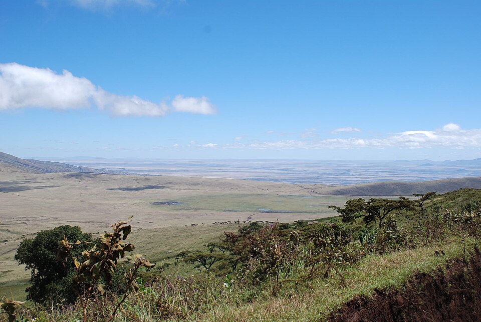
The East African Rift System (EARS) is the world's pre-eminent example of an active continental rift and the only place on Earth where the entire progression from early continental extension to incipient seafloor spreading can be observed in a single, continuous tectonic province. The system extends for more than 3,000 kilometres from the Afar Depression in northeastern Ethiopia southward through Kenya, Tanzania, and into Mozambique, splitting into two principal branches — the Eastern Branch and the Western Branch — that diverge around the Archean craton of the Tanzania Craton.3
The EARS developed progressively from north to south, with the earliest rifting in the Afar region at approximately 30 million years ago and the youngest segments in southern Tanzania and Mozambique still in the initial stages of extension. The Afar Depression, where the East African Rift intersects the Red Sea Rift and the Gulf of Aden Rift at the Afar triple junction, represents the most advanced stage of continental breakup within the system. Here, the continental crust has been stretched to less than 20 kilometres thick, and episodic dyke intrusion events — such as the dramatic 2005 Dabbahu rifting episode in which a 60-kilometre-long dyke opened along the rift axis within days — demonstrate that magmatic processes are actively replacing tectonic faulting as the dominant mode of extension, a hallmark of the transition from continental rifting to seafloor spreading.4, 23
The Ethiopian Rift, which forms the northern segment of the Eastern Branch, is a well-developed graben 50 to 80 kilometres wide flanked by the Ethiopian and Somali plateaux, both of which stand at elevations exceeding 2,500 metres. The rift floor contains a chain of lakes and active volcanoes, and the crust beneath the rift axis has been thinned to approximately 25 kilometres from a pre-rift thickness of roughly 40 kilometres.3, 17 Farther south, the Kenya Rift narrows to 40 to 50 kilometres and is characterised by prominent border faults, rift-floor volcanism including the Menengai caldera and Mount Longonot, and a chain of alkaline lakes in the rift valley.
The Western Branch, also known as the Albertine Rift, follows a more sinuous course along the western margin of the Tanzania Craton, exploiting zones of pre-existing weakness in the Proterozoic mobile belts that surround the craton. It is notably less volcanic than the Eastern Branch — many segments of the Western Branch are entirely non-volcanic — but hosts the deepest rift lakes in Africa, including Lake Tanganyika (1,470 metres deep, the second-deepest lake in the world) and Lake Kivu.3 The contrast between the magma-rich Eastern Branch and the magma-poor Western Branch within a single rift system has provided critical insights into the role of magmatism in rift development.
Development of the East African Rift System2, 3, 17
| Time (Ma) | Event | Region |
|---|---|---|
| ~45 | Uplift of the Ethiopian plateau begins; earliest alkaline volcanism | Ethiopia |
| ~30 | Eruption of Ethiopian–Yemeni flood basalts (~350,000 km³); onset of Afar plume activity | Ethiopia, Yemen |
| ~25 | Opening of the Gulf of Aden; separation of Arabia from Africa begins | Gulf of Aden |
| ~20–23 | Red Sea rifting accelerates; oceanic crust begins forming in southern Red Sea | Red Sea |
| ~15–18 | Kenya Rift faulting and volcanism begin; Turkana Depression develops | Northern Kenya |
| ~12 | Western Branch (Albertine Rift) initiation; faulting along Lake Albert and Lake Tanganyika | Western Branch |
| ~8–12 | Ethiopian Rift narrowing and magmatic focusing; caldera volcanism in the Main Ethiopian Rift | Ethiopia |
| ~5–7 | Southern Kenya Rift and northern Tanzania divergence zone develop | Southern Kenya, Tanzania |
| ~1–3 | Magmatic segments in Afar begin resembling mid-ocean ridge segments; incipient seafloor spreading | Afar Depression |
| 0 (present) | Active extension across the entire EARS; GPS-measured divergence of 6–7 mm/yr in the Main Ethiopian Rift | Entire EARS |
Volcanic versus non-volcanic rifts
Continental rifts vary enormously in the volume of magmatism that accompanies extension, and this variation has fundamental consequences for rift structure, the mechanics of lithospheric breakup, and the character of the resulting passive margin. The spectrum is conventionally described in terms of two end-members: volcanic (magma-rich) rifts and non-volcanic (magma-poor) rifts.8
Volcanic rifts are characterised by massive outpourings of basaltic magma — both as surface flood basalts and as thick igneous intrusions emplaced within the crust — that precede or accompany the onset of extension. The erupted volumes can be extraordinary: the Ethiopian flood basalt province, associated with the initiation of the East African Rift, originally covered an area exceeding 600,000 square kilometres with basalt piles up to 2,000 metres thick.2, 17 At volcanic rifted margins, the transition from continental to oceanic crust is marked by thick wedges of seaward-dipping reflectors — packages of subaerial lava flows that were erupted during breakup and subsequently tilted oceanward as the margin subsided. The passive margins of the South Atlantic, formed by the rifting of South America from Africa in the Early Cretaceous, are classic volcanic margins underlain by the Paraná-Etendeka flood basalt province.8
Non-volcanic rifts, by contrast, are characterised by extreme lithospheric stretching with little or no accompanying magmatism. Extension is accommodated almost entirely by tectonic faulting, and the crust can be thinned to the point where mantle peridotite is exhumed to the seafloor before any significant magma is generated. The Woodlark Basin in the western Pacific, where active continental rifting is transitioning to seafloor spreading in a magma-starved environment, provides a modern example of this end-member.21 The Iberia-Newfoundland conjugate margins, formed by the opening of the North Atlantic, preserve a broad zone of exhumed serpentinised mantle between the thinned continental crust and the first unambiguous oceanic crust, demonstrating that continental breakup does not always require large volumes of magma.8
The primary control on whether a rift is volcanic or non-volcanic appears to be the thermal state of the mantle beneath the rift axis. Where a mantle plume provides an anomalously hot source of asthenosphere, decompression melting begins at greater depths and produces far larger volumes of magma, yielding a volcanic rift. Where no plume is present and the mantle is at normal potential temperature, extension must proceed to much greater degrees of thinning before decompression melting can occur, and the resulting magma volumes are modest.8, 22
Basin formation and sedimentation
The subsidence created by lithospheric stretching during rifting produces sedimentary basins that are among the most economically significant geological features on Earth. The half-graben geometry of rift basins concentrates sedimentation along the hanging wall of the border fault, where accommodation space is greatest, and produces a characteristic wedge-shaped sedimentary fill that thickens toward the fault. Sediment sources include alluvial fans shed from the uplifted footwall, fluvial systems draining the rift flanks, and — in many cases — lacustrine (lake) deposits that accumulate in the topographically closed basins of the rift floor.1, 14
Rift lakes are a defining feature of continental rift systems, and several of the world's largest and deepest lakes occupy active rift basins. Lake Baikal in Siberia, the deepest lake on Earth at 1,642 metres, fills the central graben of the Baikal Rift and contains approximately 20 percent of the world's surface fresh water.10 The lacustrine sediments that accumulate in rift lakes are often rich in organic matter — deposited under anoxic bottom-water conditions in deep, stratified lake basins — and upon burial and thermal maturation these organic-rich sediments become petroleum source rocks of exceptional quality.
The petroleum systems of several major hydrocarbon provinces are rooted in rift-basin source rocks. The North Sea, one of the world's most prolific oil provinces, owes its petroleum to organic-rich lacustrine and marine shales deposited during Jurassic rifting that preceded the opening of the North Atlantic.14 The Gulf of Suez, a young rift that represents an aborted arm of the Red Sea spreading system, contains substantial oil reserves sourced from syn-rift and pre-rift organic-rich sediments now deeply buried beneath the rift fill.15 In West Africa, the lacustrine source rocks of the Early Cretaceous rift basins that preceded the opening of the South Atlantic have generated enormous volumes of oil now trapped in the post-rift passive margin sediments of the Gulf of Guinea. The systematic association between continental rifting and petroleum source rock deposition reflects the fundamental tendency of rift basins to create deep, restricted water bodies conducive to organic matter preservation.
The rift-to-drift transition
If extensional stresses persist for long enough, continental rifting progresses to the point of complete lithospheric rupture, after which new oceanic crust begins to form by seafloor spreading between the now-separated continental fragments. This transition — from continental rifting to oceanic spreading, commonly called the "rift-to-drift transition" — marks the birth of a new ocean and the transformation of the two rift flanks into passive continental margins.9
The Red Sea provides what is arguably the best natural laboratory for studying this transition, because it preserves the entire spectrum of rift evolution along its length. In the south, where rifting is most mature, a well-developed mid-ocean ridge with organised seafloor spreading has been active since at least 5 million years ago, and true oceanic crust forms the floor of the basin. In the central Red Sea, spreading is intermittent and confined to isolated deeps where small pockets of oceanic crust have formed, while the intervening areas are floored by extremely thinned continental crust or transitional crust of ambiguous character. In the northern Red Sea, no oceanic crust has yet formed, and the basin is still in the late continental rift stage, with extension accommodated by tectonic faulting and localised magmatism.16 This south-to-north gradient in rift maturity, captured in a single basin at a single moment in geological time, offers a spatial proxy for the temporal evolution of the rifting process.
The geological record of ancient rifting events confirms that the rift-to-drift transition follows a broadly similar pattern across diverse tectonic settings and geological ages. The breakup of Gondwana, which separated Africa from South America, India, Antarctica, and Australia over a period of roughly 100 million years during the Mesozoic, produced a series of rifted margins that can be matched across the conjugate continental fragments, with each pair recording the same sequence of syn-rift faulting, transitional volcanism, and post-rift thermal subsidence.7 The opening of the Atlantic Ocean is perhaps the most thoroughly studied example: Triassic and Jurassic rift basins preserved along the eastern seaboard of North America (the Newark Supergroup basins) and the western margin of Africa record the early stages of extension, while the oldest magnetic anomalies on the Atlantic seafloor date to approximately 180 million years ago, marking the onset of true seafloor spreading and the completion of the rift-to-drift transition in the central Atlantic.7
Ancient and failed rifts
Not all continental rifts progress to the point of continental breakup. Many rift systems cease extending before the lithosphere ruptures completely, leaving behind a "failed rift" or aulacogen — a fossil rift basin preserved within the interior of a continent. Failed rifts are common geological features, and their sedimentary fills, fault structures, and thermal histories provide important records of past extensional episodes and the forces that drove them.
The Basin and Range Province of the western United States and Mexico is one of the most extensive active rift provinces on Earth, spanning more than 800 kilometres from east to west and 2,000 kilometres from north to south. Extension in the Basin and Range began in the Oligocene (approximately 30 million years ago) and has produced a landscape of alternating fault-bounded mountain ranges and intervening sedimentary basins — the "basins and ranges" that give the province its name. Total extension across the province varies but locally exceeds 100 percent, and in highly extended areas such as the Death Valley region and the Metamorphic Core Complex belt, deep crustal rocks have been exhumed to the surface along low-angle detachment faults.12 The driving forces are debated but are generally attributed to the gravitational collapse of the over-thickened crust inherited from Mesozoic and early Cenozoic mountain building (the Sevier and Laramide orogenies) combined with the changing plate boundary geometry along the western margin of North America.
The Baikal Rift in Siberia, active since at least 35 million years ago, has produced a narrow but deep rift graben that hosts Lake Baikal. The rift extends for approximately 2,000 kilometres along the southern margin of the Siberian Craton and is characterised by high seismicity, modest volcanism, and extreme basin depth — the sedimentary fill beneath Lake Baikal exceeds 7 kilometres in some sub-basins.10 The driving mechanism of the Baikal Rift remains debated, with proposals ranging from far-field stresses transmitted from the India-Asia collision zone to the south, to the influence of a mantle plume beneath the rift axis.
The Rhine Graben (Upper Rhine Graben) in western Europe is a well-studied Cenozoic rift that extends approximately 300 kilometres from Basel, Switzerland, to Frankfurt, Germany, forming part of the broader European Cenozoic Rift System. Rifting began in the Eocene (~45 million years ago) in response to extensional stresses related to the Alpine collision and has produced a graben up to 40 kilometres wide and filled with several kilometres of Cenozoic sediments.11 The Rhine Graben is notable for its geothermal energy potential, its association with moderate seismicity in otherwise tectonically quiet western Europe, and its role in controlling the course of the Rhine River.
The Midcontinent Rift (Keweenawan Rift) of North America is a spectacular example of a Precambrian failed rift. Approximately 1.1 billion years ago, a major extensional event nearly split the North American continent along a curving trend that can be traced for over 2,000 kilometres from Lake Superior southwestward into Kansas. The rift produced enormous volumes of basaltic lava — with cumulative thicknesses exceeding 20 kilometres in the Lake Superior region — and substantial sedimentary fills, but extension ceased before complete continental breakup occurred.13, 20 The Midcontinent Rift is one of the largest failed rifts in the geological record and demonstrates that even highly advanced rifting events do not invariably lead to the formation of a new ocean.
Rifting, climate, and life
Continental rifting exerts a profound and often underappreciated influence on climate and biological evolution through the creation of new topography, the formation of large lakes, and the disruption of atmospheric circulation patterns. The uplift of rift flanks creates orographic barriers that intercept moisture-bearing winds, producing pronounced rain shadows and generating strong climatic gradients across distances of only a few tens of kilometres. The elevation of the East African plateaux on either side of the EARS, for instance, is a primary control on the regional climate of eastern Africa, influencing the distribution of forests, savannas, and deserts and, by extension, the evolutionary history of the organisms that inhabit them.3
The rift lakes of East Africa are among the most biologically significant water bodies on Earth. The African Great Lakes — Victoria, Tanganyika, Malawi, Albert, Edward, and Kivu — collectively harbour an extraordinary concentration of endemic species, most famously the cichlid fishes. Lake Malawi alone contains an estimated 800 to 1,000 cichlid species, the vast majority found nowhere else, while Lake Tanganyika and Lake Victoria harbour comparably diverse but independently evolved cichlid radiations.18, 19 These radiations represent some of the most spectacular examples of adaptive evolution known to science: in Lake Victoria, a flock of more than 500 species appears to have evolved from a single ancestral population within the last 15,000 years, making it one of the fastest large-scale speciation events ever documented.18
The mechanism linking rifting to this extraordinary biodiversity lies in the interplay between tectonic basin formation and lake-level fluctuations driven by climate. As rift basins deepen and fill with water, they create large, deep lakes with diverse habitats — rocky shorelines, sandy substrates, deep pelagic zones, and isolated embayments. Climatic oscillations periodically lower lake levels, fragmenting formerly continuous lake habitats into isolated pools and bays, each of which serves as an arena for independent evolutionary divergence. When lake levels rise again, the isolated populations come back into contact, and their accumulated differences may be sufficient to maintain reproductive isolation — completing the speciation process. This cycle of fragmentation and reconnection, repeated many times over millions of years and driven by the interaction of tectonic subsidence and climatic variability, has generated the astonishing species diversity observed in the African rift lakes today.19
The sedimentary records preserved in rift lake basins are also invaluable archives of past climate change. The deep, continuously deposited lacustrine sequences in lakes such as Tanganyika and Malawi extend back several million years and contain detailed records of past temperature, precipitation, vegetation, and fire history at seasonal to millennial resolution. These records have been instrumental in reconstructing the climatic context of human evolution in East Africa, linking shifts in hominin ecology, migration, and speciation to episodes of environmental variability recorded in the rift lake sediments.3
Continental rifting in the tectonic cycle
Continental rifting occupies a foundational role in the tectonic cycle as the mechanism by which supercontinents are dismembered and new oceans are born. The Wilson Cycle — the recurring sequence of ocean opening, widening, closing, and continental collision named for J. Tuzo Wilson — begins with rifting and ends with the closure of the intervening ocean at a subduction zone and the suturing of the formerly separated continental fragments into a new supercontinent.7 The geological record preserves evidence of multiple complete Wilson Cycles, each leaving behind a characteristic assemblage of rift-related rocks: failed rift basins (aulacogens), passive margin sedimentary wedges, and, at the culmination of the cycle, suture zones marked by ophiolites and deformed rift-margin sequences.
The present-day East African Rift System offers the opportunity to observe the opening stage of a Wilson Cycle in real time. If current rates of extension persist, the Somali Plate will eventually separate completely from the Nubian Plate, creating a new ocean basin in what is now eastern Africa. The Red Sea, already in the late stages of rift-to-drift transition, foreshadows the fate of the East African Rift itself: a continental rift that has progressed to become a narrow ocean, on its way to becoming a mature ocean basin comparable to the present-day Atlantic.3, 16 Continental rifting is thus not merely a process of destruction but the essential first step in the creation of new oceanic lithosphere and the renewal of the Earth's surface through the plate tectonic cycle.
References
The breakup of East Gondwana: assimilating constraints from Cretaceous ocean basins around India into a best-fit tectonic model
The Rhinegraben: a graben system controlled by gravity, extensional stress and block rotation
United Plates of America, the birth of a craton: Early Proterozoic assembly and growth of Laurentia