Overview
- The geologic time scale organizes Earth's 4.54-billion-year history into a hierarchical framework of eons, eras, periods, and epochs, calibrated by radiometric dating and defined by the fossil, chemical, and magnetic signatures preserved in the rock record.
- Stratigraphy—the study of layered sedimentary rocks—provides the relative sequence of geological events using principles first articulated in the seventeenth century, while radiometric dating assigns absolute numerical ages by measuring the predictable decay of radioactive isotopes.
- Ice ages and glaciation have repeatedly reshaped Earth's surface, with the Pleistocene glacial-interglacial cycles driven by orbital variations leaving a detailed record in ocean sediments, ice cores, and glacial landforms that documents both the mechanisms and consequences of large-scale climate change.
Earth is 4.54 billion years old, and the vast majority of that history left no written record, no oral tradition, and no human witness. Yet geologists can reconstruct the sequence of events—the formation and erosion of mountain ranges, the advance and retreat of ice sheets, the opening and closing of oceans, the mass extinctions that periodically restructured the biosphere—with remarkable precision, because the Earth itself keeps a record. That record is written in rock: in the layered sedimentary strata that accumulate on the floors of oceans, lakes, and river floodplains; in the isotopic ratios locked within mineral crystals at the moment of their formation; and in the fossils, chemical signatures, and magnetic orientations preserved within the geological column.1, 2
Reading this record requires two complementary approaches. Stratigraphy decodes the relative sequence of events from the physical and biological characteristics of layered rocks, establishing which events came first, second, and third. Radiometric dating assigns absolute numerical ages to those events by exploiting the predictable decay of radioactive isotopes. Together, these methods have produced the geologic time scale—the hierarchical chronological framework that organizes Earth's entire history and against which all geological, biological, and climatic events are measured.1
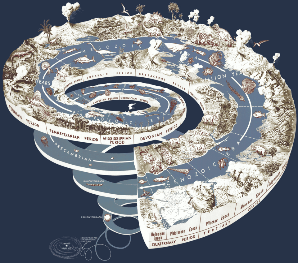
The geologic time scale
The geologic time scale divides Earth's 4.54-billion-year history into a nested hierarchy of units: eons, eras, periods, epochs, and ages. The broadest division recognizes four eons. The Hadean (4.54 to approximately 4.0 billion years ago) encompasses the planet's initial formation, differentiation into core and mantle, and the intense bombardment of its early surface. The Archean (approximately 4.0 to 2.5 billion years ago) saw the establishment of the first stable continental crust, the origin of life, and the development of microbial ecosystems dominated by stromatolite-building cyanobacteria. The Proterozoic (2.5 billion to 538.8 million years ago) witnessed the Great Oxidation Event, the evolution of eukaryotic cells and the first multicellular organisms, and the Snowball Earth glaciations. The Phanerozoic (538.8 million years ago to the present)—representing only the most recent 12 percent of Earth history—encompasses the entire visible fossil record of complex animal life, from the Cambrian explosion to the modern biosphere.1
The boundaries between these units are not arbitrary: they are defined by specific geological events preserved in the rock record. The base of the Phanerozoic Eon is defined by the first appearance of the trace fossil Treptichnus pedum in a stratotype section in Newfoundland, Canada. The Cretaceous-Paleogene boundary, 66 million years ago, is marked globally by a thin iridium-enriched clay layer deposited by the Chicxulub asteroid impact. Each boundary has a formally designated physical reference point—a Global Boundary Stratotype Section and Point (GSSP)—that serves as the international standard.1 The International Commission on Stratigraphy maintains and continuously refines the geologic time scale as new radiometric ages, fossil discoveries, and geochemical data improve the precision of boundary definitions.1
Stratigraphy: reading the rock record
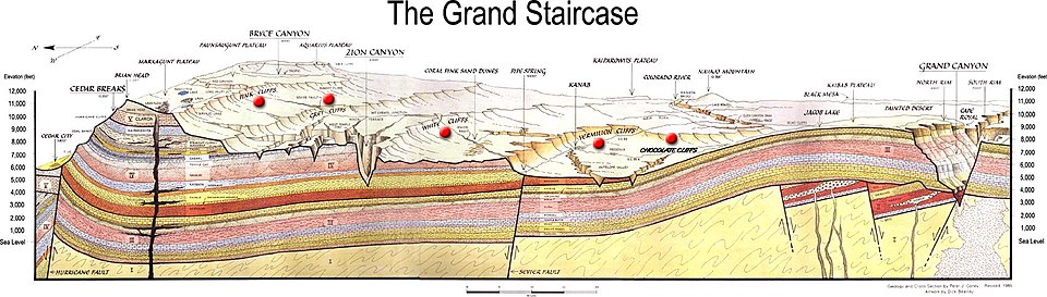
Stratigraphy is the branch of geology concerned with the study and interpretation of layered rocks—the sedimentary strata that accumulate on Earth's surface over geological time.
Sedimentary rocks encode the environmental conditions that prevailed during their deposition with extraordinary fidelity. Grain size, mineralogy, and sedimentary structures such as cross-bedding, ripple marks, and graded bedding reveal the energy and direction of the currents that transported and deposited the sediment. Fossil content identifies the organisms that inhabited or were transported into the depositional environment. Chemical and isotopic signatures—the ratios of carbon, oxygen, strontium, and sulfur isotopes in carbonate minerals, for instance—serve as proxies for past ocean chemistry, atmospheric composition, and global temperature.4 Gaps in the record, called unconformities, represent intervals of erosion or non-deposition that may span millions to hundreds of millions of years, and their recognition is essential to correct interpretation of the stratigraphic sequence.4
The practical power of stratigraphy lies in correlation: the determination that strata in geographically separated locations are the same age. Fossil-based biostratigraphy, the method pioneered by William Smith in the early 1800s, remains the primary tool for correlating Phanerozoic sedimentary sequences worldwide. For older rocks, chemostratigraphy and magnetostratigraphy—the recognition of globally synchronous chemical anomalies and magnetic polarity reversals in the rock record—provide independent correlation frameworks that complement and validate the fossil evidence.1, 4
Radiometric dating: absolute ages from atoms
While stratigraphy establishes the sequence of geological events, radiometric dating establishes their absolute timing. The method exploits the observation, first made systematic by Ernest Rutherford and Frederick Soddy in 1902, that certain unstable atomic nuclei transform spontaneously into different nuclei at rates that are fixed, predictable, and independent of temperature, pressure, or chemical environment.3 Because these transformation rates are constant, the ratio of parent atoms to daughter atoms in a mineral serves as a clock, recording the time elapsed since the mineral crystallized and its isotopic system was sealed.
Multiple independent decay systems span the full range of geological time. Uranium-lead dating, applied primarily to the mineral zircon, is the most precise method for dating rocks from millions to billions of years old and provides the absolute calibration points that anchor the geologic time scale. Potassium-argon and argon-argon dating are broadly applicable to potassium-bearing minerals and are widely used for dating volcanic rocks from a few hundred thousand to several billion years old. Rubidium-strontium and samarium-neodymium dating are valuable for ancient rocks and mantle-derived materials. Radiocarbon dating, with a practical range limited to roughly the last 50,000 years, is the primary chronological tool for Quaternary geology and archaeology.3
The most compelling evidence for the reliability of radiometric dating is the systematic convergence of independent methods. When geologists date the same rock using uranium-lead, potassium-argon, rubidium-strontium, and samarium-neodymium systems—each exploiting a different element, a different decay mechanism, and a different half-life—the results consistently agree. This convergence would be inexplicable if decay rates were not constant or if the methods were plagued by systematic errors. The agreement among independent systems, observed across the entire 4.54-billion-year history of the Earth and solar system, constitutes one of the most robust empirical achievements of modern science.2, 3
Ice ages and glaciation
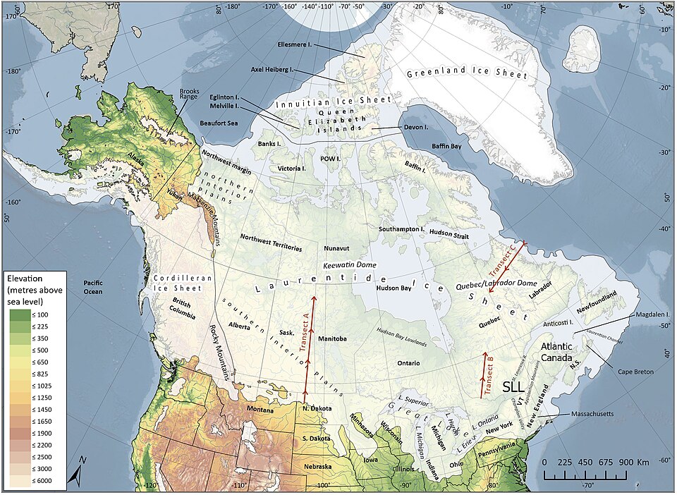
Throughout its history, Earth has experienced episodes of widespread glaciation in which continental ice sheets advanced across high and middle latitudes, sea levels dropped by over a hundred metres, and global climate cooled dramatically. The most recent of these, the Pleistocene glaciations, began approximately 2.6 million years ago and produced a series of glacial-interglacial cycles whose geological record is preserved in extraordinary detail in ocean sediment cores, ice cores, glacial landforms, and terrestrial sedimentary sequences.5
The pacing of Pleistocene glacial cycles is governed by periodic variations in Earth's orbital geometry, as demonstrated in the landmark 1976 paper by Hays, Imbrie, and Shackleton. Three orbital parameters—eccentricity (the shape of Earth's orbit around the Sun, with a period of roughly 100,000 years), obliquity (the tilt of Earth's rotational axis, with a period of roughly 41,000 years), and precession (the wobble of Earth's axis, with a period of roughly 23,000 years)—combine to modulate the seasonal and latitudinal distribution of solar radiation reaching Earth's surface. These variations do not change the total amount of solar energy received by the planet, but they alter its distribution in ways that can tip high-latitude summers below the threshold needed to melt winter snow accumulation, initiating ice-sheet growth.7
At their maximum extent during the Last Glacial Maximum, approximately 26,500 to 19,000 years ago, ice sheets up to 3 to 4 kilometres thick covered much of North America, northern Europe, and Siberia. Global sea level was roughly 120 to 130 metres lower than today, exposing vast areas of continental shelf and creating land bridges—including Beringia, which connected Asia to North America and served as the route for the initial human colonization of the Americas.5, 8 The current Holocene interglacial began approximately 11,700 years ago with the rapid retreat of the ice sheets, a transition that coincided with the spread of agriculture and the emergence of the earliest complex human societies.5
The Pleistocene glaciations are not the only ice ages in Earth's history. During the late Paleozoic, roughly 360 to 260 million years ago, the supercontinent Gondwana experienced extensive glaciation, leaving tillites and striated bedrock across what are now South America, Africa, India, and Australia—evidence that Alfred Wegener cited in support of continental drift.8 Still earlier, during the Neoproterozoic, roughly 720 to 635 million years ago, the most extreme glaciations in the geological record occurred: the Snowball Earth events, in which geological and geochemical evidence suggests that ice sheets may have reached equatorial latitudes, with profound consequences for ocean chemistry and the subsequent evolution of complex multicellular life.8